Tag: solar system

  • Moonlight and Our Atmosphere

    The Moon looks nearly full from the viewpoint of the International Space Station. Below, we can see the Moon's light being refracted by Earth's atmosphere. A few clouds can be seen at the bottom of the image.
    NASA

    The Moon’s light is refracted by Earth’s atmosphere in this April 13, 2025, photograph from the International Space Station as it orbited into a sunset 264 miles above the border between Bolivia and Brazil in South America.

    Understanding the Moon helps us understand other planets, how they have evolved and the processes which have shaped their surfaces. It also helps us understand the influence the Moon has had on Earth, the record of the ancient Sun, and it serves as a platform to study the rest of the universe. By using the Moon as our closest testing ground for robotics and instrument systems, we can further human exploration to not only the Moon, but the rest of the solar system.

    Through Artemis missions, NASA will send astronauts to explore the Moon for scientific discovery, economic benefits, and to build the foundation for the first crewed missions to Mars.

    Image credit: NASA

  • NASA-funded Compact Radar Drives Big Changes in Airborne and Suborbital Radar Capabilities

    A collaboration between NASA and the small business Aloft Sensing produced a new compact radar system that will enable researchers to leverage High Altitude Long Endurance (HALE) platforms to observe dynamic Earth systems. This new radar is small, provides highly sensitive measurements, and doesn’t require GPS for positioning; eventually, it could be used on vehicles in space.

    A hot-air balloon hoisting a complex radar instrument, mid-flight.
    HALE InSAR flies aboard a high-altitude balloon during a test-flight. This lightweight instrument will help researchers measure ground deformation and dynamic Earth systems.
    Credit: Aloft Sensing

    Long before a volcano erupts or a mountainous snowpack disappears, millimeter-scale changes in Earth’s surface indicate larger geologic processes are at work. But detecting those minute changes, which can serve as early warnings for impending disasters, is difficult.

    With support from NASA’s Earth Science Technology Office (ESTO ) a team of researchers from the small aerospace company Aloft Sensing is developing a compact radar instrument for observing Earth’s surface deformation, topography, and vegetation with unprecedented precision.

    Their project, “HALE InSAR,” has demonstrated the feasibility of using high-altitude, long-endurance (HALE) vehicles equipped with Interferometric Synthetic Aperture Radar (InSAR) to observe changes in surface deformation mere millimeters in size and terrain information with centimetric vertical accuracy.

    “It’s a level of sensitivity that has eluded traditional radar sensors, without making them bulky and expensive,” said Lauren Wye, CEO of Aloft Sensing and principal investigator for HALE InSAR.

    HALE vehicles are lightweight aircraft designed to stay airborne for extended periods of time, from weeks to months and even years. These vehicles can revisit a scene multiple times an hour, making them ideal for locating subtle changes in an area’s geologic environment.

    InSAR, a remote sensing technique that compares multiple images of the same scene to detect changes in surface topography or determine structure, is also uniquely well-suited to locate these clues. But traditional InSAR instruments are typically too large to fly aboard HALE vehicles.

    HALE InSAR is different. The instrument is compact enough for a variety of HALE vehicles, weighing less than 15 pounds (seven kilograms) and consuming fewer than 300 watts of power, about as much energy as it takes to power an electric bike.

    HALE InSAR leverages previously-funded NASA technologies to make such detailed measurements from a small platform: a novel electronically steered antenna and advanced positioning algorithms embedded within an agile software-defined transceiver. These technologies were developed under ESTO’s Instrument Incubation Program (IIP) and Decadal Survey Incubation (DSI) Program, respectively.

    “All of the design features that we’ve built into the instrument are starting to showcase themselves and highlight why this payload in particular is distinct from what other small radars might be looking to achieve,” said Wye.

    One of those features is a flat phased array antenna, which gives users the ability to focus HALE InSAR’s radar beam without physically moving the instrument. Using a panel about the size of a tablet computer, operators can steer the beam electronically, eliminating the need for gimbles and other heavy components, which helps enable the instrument’s reduced size and weight.

    A white rectangulst structure attached to a larger structure with two metal brackets
    A close up HALE InSAR fixed to a high-altitude airship. The flat planar antenna reduces the instruments mass and eliminates the need for gimbles and other heavy components.
    Credit: Aloft Sensing

    “SAR needs to look to the side. Our instrument can be mounted straight down, but look left and right on every other pulse such that we’re collecting a left-looking SAR image and a right-looking SAR image essentially simultaneously. It opens up opportunities for the most mass-constrained types of stratospheric vehicles,” said Wye.

    Using advanced positioning algorithms, HALE InSAR also has the unique ability to locate itself without GPS, relying instead on feedback from its own radar signals to determine its position even more accurately. Brian Pollard, Chief Engineer at Aloft Sensing and co-investigator for HALE InSAR, explained that precise positioning is essential for creating high-resolution data about surface deformation and topography.

    “SAR is like a long exposure camera, except with radio waves. Your exposure time could be a minute or two long, so you can imagine how much smearing goes on if you don’t know exactly where the radar is,” said Pollard.

    Navigating without GPS also makes HALE InSAR ideal for field missions in austere environments where reliable GPS signals may be unavailable, increasing the instrument’s utility for national security applications and science missions in remote locations.

    The Aloft Sensing team recently achieved several key milestones, validating their instrument aboard an airship at 65,000 feet as well as small stratospheric balloons. Next, they’ll test HALE InSAR aboard a fixed wing HALE aircraft. A future version of their instrument could even find its way into low Earth orbit on a small satellite.

    Wye credits NASA support for helping her company turn a prototype into a proven instrument.

    “This technology has been critically enabled by ESTO, and the benefit to science and civil applications is huge,” said Wye. “It also exemplifies the dual-use potential enabled by NASA-funded research. We are seeing significant military interest in this capability now that it is reaching maturity. As a small business, we need this hand-in-hand approach to be able to succeed.”

    For more information about opportunities to work with NASA to develop new Earth observation technologies, visit esto.nasa.gov.

    For additional details, see the entry for this project on NASA TechPort.

    Project Lead: Dr. Lauren Wye, CEO, Aloft Sensing

    Sponsoring Organization: NASA’s Instrument Incubation Program (IIP)

  • Where the Wild Things Are: Wildlife Management with Johnson’s Matt Strausser

    If you asked someone what they expected to see during a visit to NASA’s Johnson Space Center, they would probably list things like astronauts, engineers, and maybe a spacecraft or two. It might be a surprise to learn you can also spy hundreds of species of animals – from geckos and snakes to white-tailed deer and red-tailed hawks.

    Ensuring those species and Johnson’s workforce can safely coexist is the main job of Matt Strausser, Johnson’s senior biologist for wildlife management. Strausser works to reduce the negative impacts animals can have on Johnson’s operations as well as the negative impact humans might have on native wildlife and their habitats.

    A bearded man wearing a blue-gray baseball hat, blue and white-checked shirt, and khaki pants, stands in a field of long, dry grasses, holding onto a strand that is taller than him.
    NASA’s Johnson Space Center Senior Biologist Matt Strausser leads a nature hike to Johnson staff that detailed the native plant species and wildlife onsite, invasive species, and mitigation efforts.
    NASA/Lauren Harnett

    Strausser joined NASA in 2012, fresh out of graduate school, when he was hired on a six-month contract to write Johnson’s first Wildlife Management Plan. “My contract was extended a couple of times until I became a regular part of the facilities service contract, which is where I still am today,” he said.

    Strausser remembers being interested in natural resources from a young age. “I spent a lot of my childhood poring through copies of National Geographic, hiking, and camping,” he said. When it was time for college, Strausser decided to study biology and natural resource management. He spent his summers in jobs or internships that mostly involved endangered wildlife species, including Attwater’s prairie chickens, which are bred at Johnson through a partnership with the Houston Zoo. Strausser noted that he conducted research across the country while he was a student, and even studied fish for a short time in the South Pacific.

    “After all of those adventures in faraway places, I find it ironic that I ended up about 20 miles from where I grew up,” he said. “Once I got onsite, it did not take me long to find that this property has great remnant native plant communities, a fascinating land use history, and some unique natural resource challenges that come from the work done here. Those factors really drew me in and helped motivate me to build a career at Johnson.”

    A bearded man wearing a gray blazer, white button down shirt, and jeans accepts an award from a NASA astronaut, with two women in professional clothing to his right.
    Matthew Strausser received a Silver Snoopy Award through NASA’s Space Flight Awareness Program in 2018, in recognition of his efforts to prevent and mitigate ant-inflicted damage to critical infrastructure electrical systems. From left: NASA astronaut Reid Weissman, Strausser, Strausser’s wife Kayla, NASA Acting Associate Administrator Vanessa Wyche.
    NASA

    Strausser’s work involves a variety of activities. First, he gathers data about Johnson’s wildlife populations and their habitats. “I use population counts, conflict records, satellite and aerial imagery, nest surveys, outside reports, and even historical data to get an understanding of what’s on the landscape and what problems we have to tackle,” he said.

    With that information, Strausser works to engage project and facility managers and provide recommendations on how to prevent or reduce the impact of wildlife problems onsite. Strausser works with Johnson’s facilities maintenance group to modify buildings to keep animals on the outside, and he gets support from the Johnson veterinarian on animal health issues. He also works closely with Johnson’s pest control and groundskeeping contracts, as their work is often adjacent to wildlife management.

    He supports the safety team, as well. “Our security contractors are a great resource for reporting wildlife issues as well as helping address them,” Strausser said, adding that some of Johnson’s safety groups “have been really helpful at getting the word out about how to stay safe around our wildlife” in coordination with the center’s internal communications team.  His team also responds to wildlife conflict calls, which often involve capturing and relocating animals that have wandered into areas where they pose a risk to people or operations.

    Additionally, Strausser runs the facilities contract’s small unmanned aircraft system, which uses drones to conduct facility inspections, support hurricane response, and survey on-site wildlife.

    A birds-eye-view of an alligator sunning itself on a rock in the middle of a tree-lined pond.
    An on-site wildlife snapshot captured by the Johnson Space Center facilities contract’s small unmanned aircraft system.
    NASA

    The nature of his work has instilled in Strausser an appreciation for teamwork and collaboration among colleagues with distinct experiences. Each of the projects he works on involves team members from different organizations and contracts, and most of them do not have a background in biology. “Building a wildlife and natural resource program from the ground up and bringing all of these once-disconnected and diverse professionals together to effectively address problems – that is the achievement I take the most pride in,” he said.

    Strausser observed that accomplishing the goals of the agency’s Artemis campaign will require a tremendous amount of specialized support infrastructure, and that developing and running that infrastructure will require a wide variety of professionals. “It is going to require students and specialists with all different types of backgrounds, passions, and talents.”

    Overall, Strausser said he has a very dynamic job. “Wildlife issues tend to be very seasonal, so throughout the year, the types of issues I am addressing change,” he said. “On top of that, there are always new projects, problems, and questions out there that keep the work fresh and challenging.” He has learned the value of being open to new challenges and learning new skills. “Being adaptable can be just as important as mastery in a specific field,” he said.

  • Summary of the 54th U.S.–Japan ASTER Science Team Meeting

    12 min read

    Summary of the 54th U.S.–Japan ASTER Science Team Meeting

    Introduction

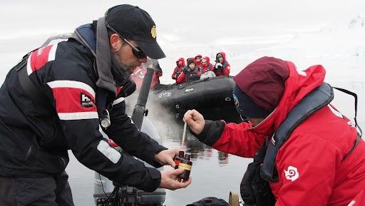
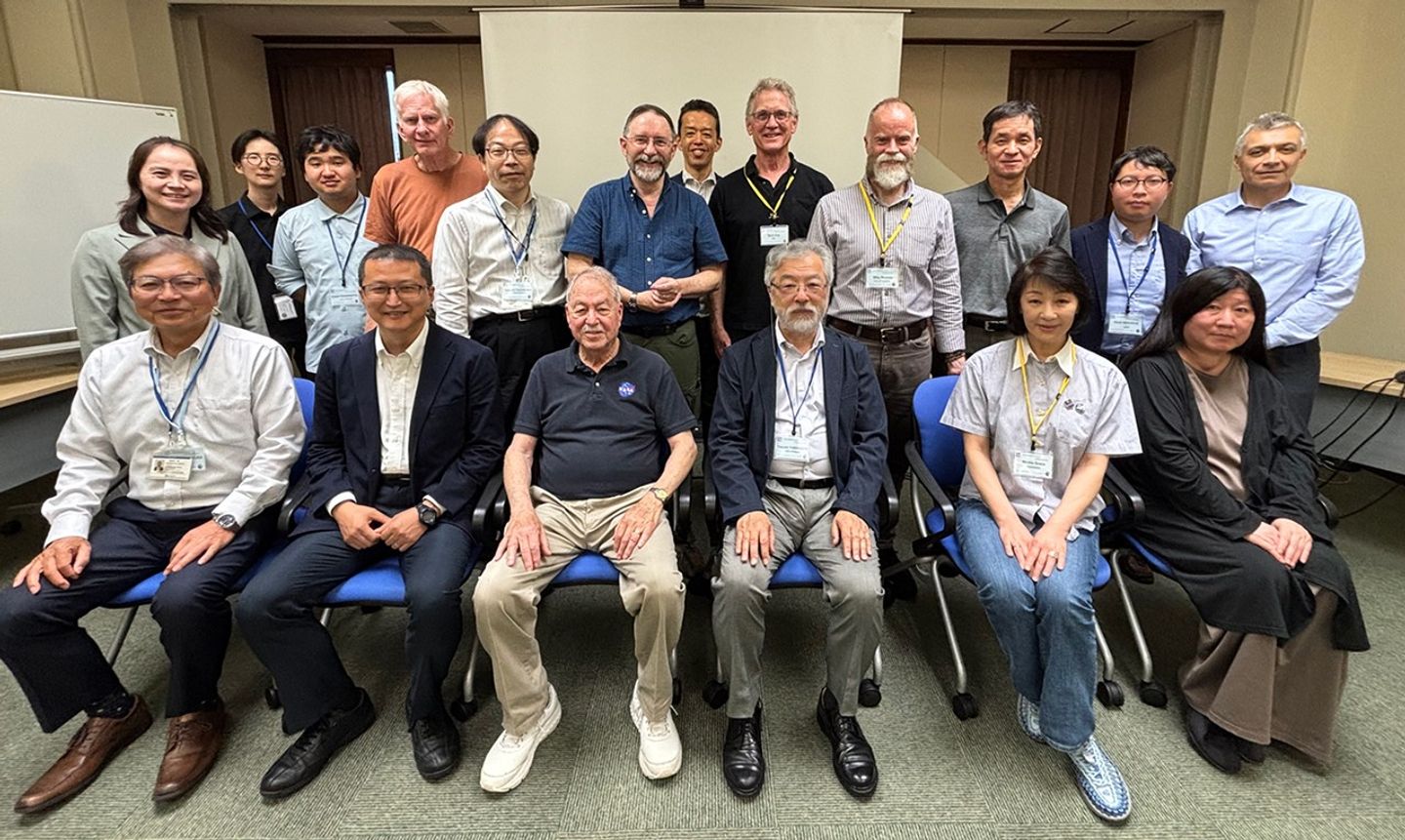
    The Advanced Spaceborne Thermal Emission and Reflection Radiometer (ASTER) Science Team (ST) organized a three-day workshop that took place June 9–11, 2025, at the Japan Space System’s (JSS) offices in Tokyo, Japan. About 25 people from Japan and the United States participated during the in-person meeting – see Photo 1.

    U.S. participants included representatives of NASA/Jet Propulsion Laboratory (JPL); two universities – University of Arizona (UA) and University of Pittsburgh (UPitt); and Grace Consulting. Japanese participants represented JSS, the Geologic Survey of Japan (GSJ), National Institute of Advanced Industrial Science and Technology (AIST), National Institute for Environmental Studies (NIES), and the Remote Sensing Technology Center of Japan (RESTEC). Participants from Ibaraki University (IU), Nagoya University (NU), University of Tokyo (UT), and University of Tsukuba (Uts) also joined.

    ASTER photo 1
    Photo 1. Several attendees sit for a photo at the 54th ASTER Science Team meeting at the Japan Space System’s offices in Tokyo, Japan.
    Photo credit: Osamau Kashimura

    The main objectives of the 54th ASTER STM were to:

    • discuss impacts of the proposed NASA budget reductions for Fiscal Year (FY) 2026;
    • respond to plans for future impacts on ASTER from possible power reductions on the Terra platform;
    • receive updates on data acquisition status, data calibration and validation (cal/val) activities, data distribution plans, and applications using ASTER observations; and
    • discuss the end-of-mission plans for Terra and ASTER and archive documentation requirements.

    The remainder of this article summarizes the highlights from the meeting, which includes an overview of the opening plenary session and summaries of the four working group sessions. A brief review of the closing plenary, which included summary reports from the chairpersons of all working groups, rounds out the report, followed by some overall concluding thoughts.

    Opening Plenary Session

    Yasushi Yamaguchi [NU—Japan ASTER ST Lead] and Michael “Mike” Abrams [JPL—U.S. ASTER ST Lead] welcomed participants and reviewed the agenda for the opening plenary and the schedule for the working group sessions.

    Abrams presented highlights of science results based on ASTER data. He also discussed some issues that Woody Turner [NASA Headquarters—ASTER Program Scientist] had raised, including NASA’s response to the President’s proposed fiscal year (FY) 26 budget and the status of FY25 funding. Abrams reported that Terra passivation is currently scheduled for February 2027 and described Terra’s power status. [UPDATE: If the President’s proposed FY26 budget goes into effect without modification by Congress, the three Flagship missions will enter accelerated Phase F (closeout); Terra passivation would start in November 2025 and be complete by March 2026.]

    Abrams reviewed the status of the Terra spacecraft, showing slides provided by Jason Hendrickson [GSFC]. The Flight Operations Team staffing remains constant. Science data capture for ASTER remains above 99%. The impact of the shunt failure on November 28, 2024 required the safe halting of the instrument. Visible-near-infrared (VNIR) observations resumed in mid-January, and thermal infrared (TIR) observations resumed in mid-May. Collision avoidance events continue to be part of normal operations.

    Hitomi Inada [JSS] provided a status report on the ASTER instrument. Many of the monitored components (i.e., VNIR pointing motor) are beyond their original useful life in orbit, but the aging hardware shows no signs of wearing out or a decrease in performance. She showed data that indicated that the temperature and current telemetry trends remain stable.

    Abrams presented ASTER product distribution statistics provided by Cole Krehbiel [Land Processes Distributed Active Archiver Center (LP DAAC]). The ASTER Digital Elevation Model continues to be the most ordered product among all users of ASTER data. As defined by the ST at the last meeting, most ASTER data products [e.g., Version 4 (V4) products] are being created and placed in a searchable/orderable archive that can be accessed through NASA’s Earthdata tool. Abrams reported that the LP DAAC started producing these files in January 2025 and will be finished before August 2026.

    Koki Iwao [GSJ] presented AIST’s product distribution statistics. Over 4.7 million scenes have been acquired and processed to Level 1A (L1A) since June 10, 2025. AIST continues to distribute ASTER’s pseudo-natural color scenes in keyhole mark-up language (KML – a file format used to display geographic data) and scene-based Digital Elevation Models. The largest number of users of Japanese products are from the United States.

    Tetsushi Tachikawa [JSS] summarized the status of ASTER observations since the beginning of the mission. He reported that all of the global observation programs are functioning normally, acquiring data as planned. Updates to the observation programs will be considered by this week’s working groups. Tachikawa also added that the change of the orbit repeat – after Terra’s October 2022 exit from the Morning Constellation – has been accommodated in the ASTER scheduler.

    Abrams presented a report on behalf of Simon Hook [JPL], who was unable to attend the meeting. Hook’s information provides a status update for the multispectral TIR instrument on NASA’s ECOsystem Spaceborne Thermal Radiometer Experiment on Space Station (ECOSTRESS) mission. Abrams also spoke about NASA’s future Surface Biology and Geology (SBG) mission, which is part of the planned Earth System Observatory.

    Applications Working Group

    The applications session provided a sampling of how ASTER data are used.  A few examples are highlighted below. The second half of the session was devoted to a discussion of end-of-mission documentation requirements. This included a review of the NASA guiding document and sharing of existing documents.

    Michael Ramsey [UPitt] presented work on forecasting volcanic activity with the ASTER long-term archive. His team developed a statistical detection code to extract accurate temperature anomalies for five test volcanoes over 25 years. They used these results to train a deep learning approach for anomaly detection in future TIR data. The method showed 73% success for Piton del la Fournaise volcano, Réunion island, and near 100% success for Sheveluch volcano, Kamchatka Krai, Russia.

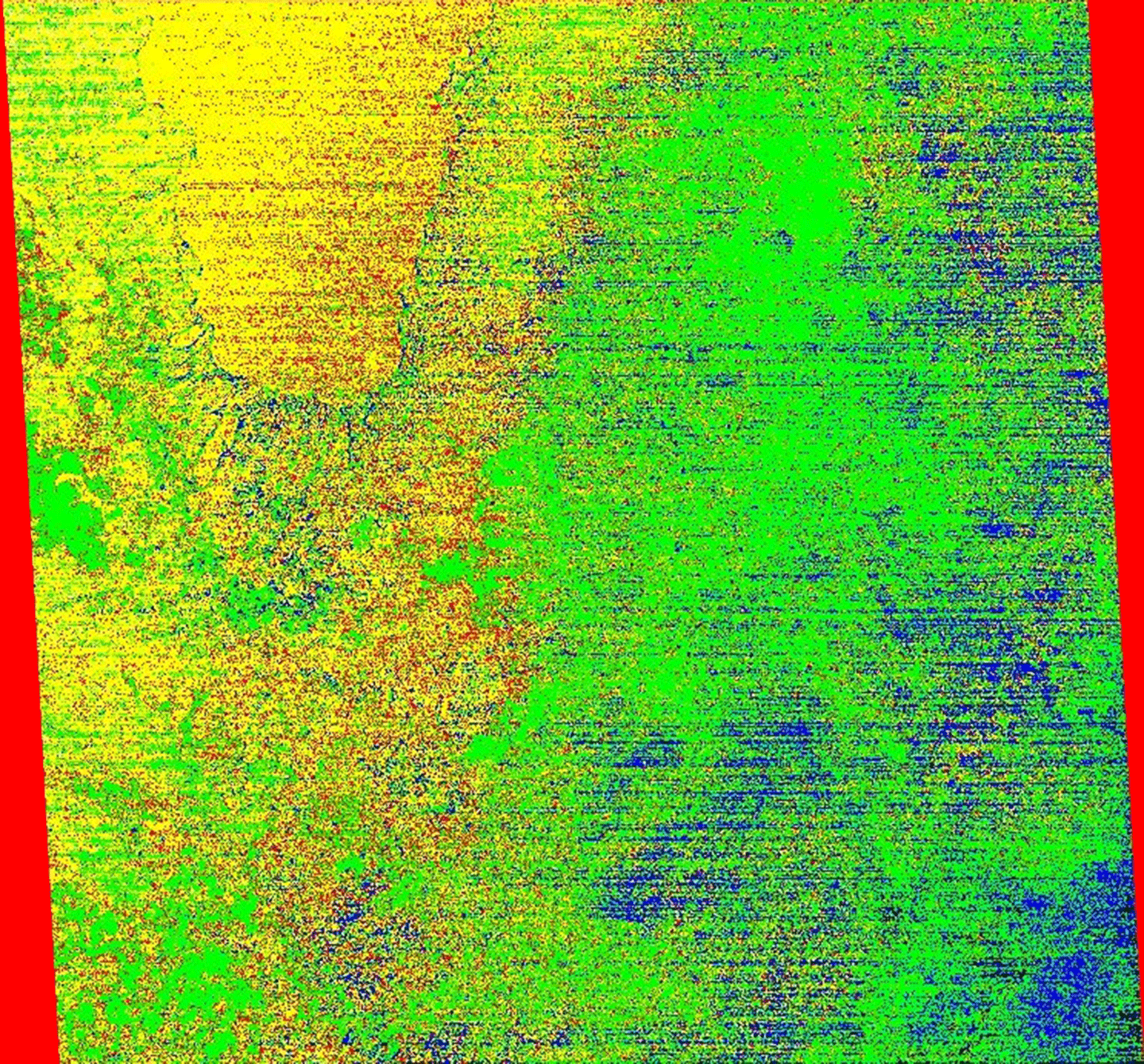
    Miyuki Muto [IU] reported on waste volume changes in 15 open landfills in developing countries using more than 20 years of ASTER time-series digital surface models – see Figure 1. The method was found to be consistent with reports using synthetic aperture radar (SAR) data, which dates to 2016. Thus, ASTER can provide a longer time series for future optical or radar studies.

    ASTER figure 1
    Figure 1. Time variation in the relative volume of waste for landfills, obtained from ASTER time-series digital surface model data for the four Indian sites – Ghazipur, Bhalswa, Okhla, and Deonar.
    Figure credit: Figure taken from Muto and Tonooka (2025), Sensors

    Mike Abrams presented the 25-year history of ASTER data applied to geologic mapping and mineral exploration. He explained how the first published papers appeared a few years after launch and validated the unique mineralogical information contained in the ASTER data. Over the following 20 years, several reports from mineral exploration companies announced the discovery of gold, chromite, and lithium deposits, which were found largely based on analysis of ASTER data.

    Calibration/Validation Working Group

    The Calibration/Validation (cal/val) working group is responsible for monitoring the radiometric and geometric performance of ASTER’s VNIR and TIR instruments. Three different cal/val techniques are used including: analysis of onboard calibration lamps, comparison with onboard blackbodies, and measurements of pseudo-invariant ground targets during field campaigns. The L2 software algorithms are being updated for the final, archival processing which is anticipated to be completed in May 2026.

    Bjorn Eng [JPL] reported that the newest version of the L2 algorithm for ASTER VNIR and TIR cal/val was delivered to the LPDAAC for ingest and testing. Eng explained how the new software includes Modern-Era Retrospective Analysis for Research and Applications, Version 2 (MERRA-2) data, which allows users to create atmospheric profiles for temperature, pressure, water vapor, and ozone. MERRA-2 is an improvement – both spatially and temporally – over the National Centers for Environmental Prediction’s Global Data Assimilation System that is used in the original MERRA. The new L2 production algorithms were validated, and the LP DAAC began incorporating the algorithms into the static archive in January 2025.

    Mike Abrams presented on behalf of Cole Krehbiel [LP DAAC] and reported on the assessment of geometric performance of the L1 processing software, which was updated to the new Landsat ground control point library. He also presented an improved global digital elevation model. The ASTER final processing campaign uses the improved control point library.

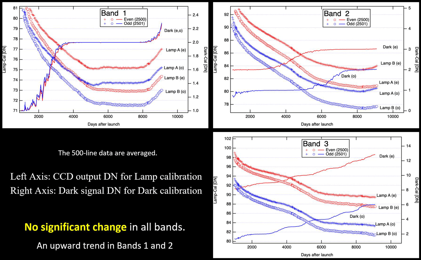
    Satoru Yamamoto [GSJ] presented updates to the calibration trends of the onboard VNIR lamps. Two onboard calibrations were performed on September 20, 2024 and November 8, 2024. Several analyses of the calibration lamps showed no significant change in the data trends – see Figure 2. The signal-to-noise ratios are still greater than the requirement of 140.

    ASTER figure 2
    Figure 2. Onboard lamp calibration data for Bands 1, 2, and 3. The lamp data show no significant change in the three bands after updating the calibration.
    Figure credit: Satoru Yamamoto

    Soushi Kato [RESTEC] presented results from his September 2024 field campaign in Nevada and Utah. The campaign was marked by clear weather during ASTER’s day and night overpasses. Kato compared his in situ TIR measurements with the standard ASTER temperature products from the LP DAAC. The agreement for the five AESTER TIR bands was within ± 1.5 K.

    Hideyuki Tonooka [IU] presented the results of his TIR field calibration campaigns at the same time and location as those conducted by Kato (described in previous presentation summary). Additionally, he reported that several calibration campaigns conducted at Lake Kasumigaura, Japan were cancelled due to cloudy weather, which led to the suspension of ASTER data acquisition. Tonooka compared his in situ TIR measurements with the standard ASTER temperature products from the LP DAAC. The agreement for the five ASTER TIR bands was within ± 1.3 K, except for band 10 at the Utah site where the discrepancy was -2.3 K.

    Temperature–Emissivity Working Group

    This group focuses on ASTER’s kinetic temperature and emissivity products, as well as application of these products and review of the nighttime TIR global mapping program status.

    Mike Abrams presented his analyses of the ASTER Level-2 Surface Kinetic Temperature Product (AST_08) for a nighttime scene acquired over Lake Tahoe, CA. He compared the on-demand MERRA-2 product from NASA’s Global Modeling and Assimilation Office with the archive-produced product. The comparison showed that the two products were identical, pixel-by-pixel. Abrams conducted a second analysis to compare the archived MERRA_2 AST_08 product with the on-demand Moderate Resolution Imaging Spectroradiometer (MODIS) AST-08 product to assess the difference in temperature due to improved MERRA-2 atmospheric parameters. The MERRA-2 product had lower temperature values for higher elevations and higher values for lower elevations with more column water vapor – see Figure 3. This result is physically correct and validates the improvement using MERRA-2 atmospheric data.

    ASTER figure 3
    Figure 3. Colorized difference by temperature, in Kelvin, between the product using MERRA-2 and MODIS atmospheric values: blue -1.0 to -0.6; green -0.5 to -0.1; red 0.0; and yellow 0.1 to 0.5.
    Figure credit: Michael Abrams

    Hideyuki Tonooka discussed the status of installation of the JPL radiometer at Lake Kasumigaura. The plan is to mount the radiometer on an existing observation in the middle of the lake. The radiometer will be operated jointly by JPL and IU. The installation is planned to start in the Summer 2025.

    Tetsuchi Tachikawa reviewed the status of the current Thermal Global Mapping acquisition program to acquire cloud-free TIR nighttime images over most of the Earth’s land surface. He explained that the program is refreshed every year, with most recent refresh beginning May 2025.

    Operations and Mission Planning Working Group

    The Operations and Mission Planning Working Group oversees and reviews the acquisition programs executed by the ASTER scheduler. Because ASTER data acquisitions have to be scheduled every day to accommodate ASTER’s average 8% duty cycle, ST members developed an automatic program to select 600–700 daily scenes from the possible 3000 plus images uploaded in the request archive.

    Tachikawa reviewed the status of acquisition scheduling. Urgent observations receive the highest priority and can be scheduled close to acquisition time. Approximately 70 scenes are programmed per month – with over 95% acquisition success. By contrast, global mapping data acquisitions receive the lowest priority and are used to fill in the scenes for the daily quota. He explained that the goal of the ASTER is to have the instrument acquire at least one cloud-free image for every place on Earth. Due to persistent cloud cover, success is typically ~85% after several years, at which time the program is restarted. Tachikawa next gave short updates on three other acquisition programs that focus on islands, volcanoes, glaciers, and cloudy areas, respectively. The global volcano image acquisition program will continue with no change to the observation parameters. Acquisition of images of islands and over cloudy areas will also continue in current form. The global glacier acquisition program will be modified to change the VNIR gain settings to optimize images over snow and ice.

    Tachikawa also discussed the effect of the ASTER shutdown in November 2024 and cessation of all ASTER data acquisitions. VNIR-only acquisitions were resumed in January 2025, and TIR acquisitions resumed in May 2025, with full operations and acquisitions of data from both VNIR and TIR instruments.

    Closing Plenary Session

    Each chairperson summarized the presentations, discussions, and recommendations that occurred during their respective working group session. The overall consensus maintained that the ASTER instrument is operating normally again – with no indications of any component failures. The ST is preparing to absorb the impact of the 50% budget reduction on the Flight Operation Team at GSFC. At this time, the main impact has been a small increase in lost data (1–2%) as a result of the absence of operators to attempt immediate recovery. The ST also approved plans for ASTER’s contribution to the Terra power mitigation plan, and the recommendation has been forwarded to the Terra Project Scientist and the Flight Operations Team.

    Conclusion

    The 54th ASTER ST Meeting successfully covered all critical issues introduced during the Opening Plenary Session. The ST worked on formulating priorities for reduction of ASTER instrument operations in response to possible future Terra power reductions. During working group sessions, participants received updates on a variety of topics (e.g., instrument scheduling, instrument performance, archiving plans, and new applications). Although this may be the last Joint U.S./Japan ASTER ST Meeting, the 55th joint meeting was tentatively scheduled for May 2026.

    Acknowledgments

    The lead author’s work on this article was carried out at the Jet Propulsion Laboratory, California Institute of Technology, under a contract with NASA.

    Michael Abrams
    NASA/Jet Propulsion Laboratory/California Institute of Technology
    mjabrams@jpl.nasa.gov

    Yasushi Yamaguchi
    Nagoya University/Japan Science and Technology Agency
    yasushi@nagoya-u.jp

    Details

    Last Updated

    Aug 18, 2025

    Related Terms

  • Bone Loss Research Launches Aboard NASA’s SpaceX-33 Resupply Mission

    The 33rd SpaceX commercial resupply services mission for NASA, scheduled to liftoff from the agency’s Kennedy Space Center in Florida in late August, is heading to the International Space Station with an important investigation for the future of bone health.

    The experiment will test how microgravity affects bone-forming and bone-degrading cells and explore potential ways to prevent bone loss. This research could help protect astronauts on future long-duration missions to the Moon and Mars, while also advancing treatments for millions of people on Earth who suffer from osteoporosis.

    Microscopic image of red-stained mesenchymal stem cells scattered across a gray background.
    Mesenchymal stem cells (MSCs) are derived from human bone marrow and stained with rapid red dye
    NASA

    Space’s Hidden Health Mystery

     During long-duration missions, astronauts may experience a gradual reduction in bone density—typically around 1% to 2% per month—even with consistent exercise routines. While scientists understand how bones work on Earth, they aren’t sure exactly why bones weaken so quickly in microgravity.

    Previous research aboard the space station revealed that microgravity changes how stem cells behave and what substances they release. Scientists now want to dig deeper into these cellular changes to better understand what causes bone loss in space and explore potential ways to prevent it.

    Blocking a Potential Bone Thief

    The Microgravity Associated Bone Loss-B (MABL-B) investigation focuses on special stem cells called mesenchymal stem cells, or MSCs. As these cells mature, they build new bone tissue in the body.

    Scientists suspect that a protein called IL-6 might be the culprit behind bone problems in space. Data from the earlier MABL-A mission suggests that microgravity promotes the type of IL-6 signaling that enhances bone degradation. The MABL-B experiment will investigate this by testing ways to block this IL-6 signaling pathway.

    The experiment will grow mesenchymal stem cells alongside other bone cells in special containers designed for space research. Cells will be cultured for 19 days aboard the space station, with crew members periodically collecting samples for analysis back on Earth.

    How this benefits space exploration

    The research could lead to targeted treatments that protect astronauts from bone loss during long-duration missions to the Moon, Mars, and beyond. As crews venture farther from Earth, bone health becomes increasingly critical since medical evacuation or emergency return to Earth won’t be possible during Mars missions.

    How this benefits humanity

    The findings could provide new insights into age-related bone loss that affects millions of people on Earth. Understanding how the IL-6 protein affects bone health may lead to new treatments for osteoporosis and other bone conditions that come with aging.

    Related Resources

    About BPS

    NASA’s Biological and Physical Sciences Division pioneers scientific discovery and enables exploration by using space environments to conduct investigations not possible on Earth. Studying biological and physical phenomenon under extreme conditions allows researchers to advance the fundamental scientific knowledge required to go farther and stay longer in space, while also benefitting life on Earth.

  • NASA, Army National Guard Partner on Flight Training for Moon Landing

    5 Min Read

    NASA, Army National Guard Partner on Flight Training for Moon Landing

    By Corinne Beckinger
    When Artemis astronauts land on the Moon’s South Pole in a commercial human landing system, they will encounter a landscape pockmarked with deep craters, sloped connecting ridges, and harsh lighting conditions. The Moon’s lack of contrast, combined with its rolling terrain, will also pose a challenge, making it difficult for astronauts to overcome visual illusions on the lunar surface.

    A Point of View of someone sitting behind two people flying a helicopter with a snowy tree filled landscape below.
    NASA astronaut Bob Hines (left) and Colorado Army National Guard HAATS instructor Ethan Jacobs practice landing procedures in the Rocky Mountains of Colorado in April 2025. Depending on the season, the snowy or dusty conditions can cause visual obstruction. Lunar dust can cause similar visual impairment during future crewed missions.

    In the mountains of northern Colorado, NASA and the U.S. Army National Guard are using military helicopters to develop a foundational lunar landersimulated flight training course to help astronauts practice flight and landing procedures for the Moon. 

    For decades, military helicopter pilots have trained at the HAATS (High-Altitude Army National Guard Aviation Training Site) in Gypsum, Colorado. In 2021, NASA and the Colorado Army National Guard began working together to develop a course specifically for the next generation of lunar explorers.

    That NASA-specific course is scheduled to be finalized in August 2025, marking an important milestone for Artemis crewed landings training efforts.

    “NASA is using a three-pronged approach with motion-based simulation, in-flight lunar landing analog training, and in-flight lunar simulation to build out its foundational training for Artemis Moon landings,” said NASA astronaut Doug Wheelock, who helped coordinate the training program. “Helicopters at or above 10,000 feet are not really efficient in the thin air, forcing us into operating with very thin power margins similar to the Apollo astronauts having to manage energy and momentum to land safely. The operations along with the terrain at the HAATS course in Colorado’s Rocky Mountains provide a valuable, real-world opportunity for Artemis astronauts to practice flying and landing in conditions similar to maneuvering a lander in the lunar environment.”

    NASA’s human landing systems that will safely transport astronauts to and from the Moon’s surface will be provided by SpaceX and Blue Origin.

    NASA’s Artemis III mission will build on earlier test flights and add new capabilities, including SpaceX’s Starship Human Landing System and advanced spacesuits, to send the first astronauts to explore the lunar South Pole and prepare humanity to go to Mars.

    While each industry provider is responsible for training Artemis astronauts on its specific lander, NASA is establishing foundational training to help prepare astronauts for crewed flights.

    Flight training opportunities like this are vital to mission success and crew safety.”

    Doug Wheelock

    Doug Wheelock

    NASA Astronaut

    “Over the last few years, NASA and the Army National Guard have worked closely to evaluate training procedures and landing zone areas, incorporating accounts from Apollo astronauts,” Wheelock said. “During training flights at HAATS, astronauts can experience the visual illusions, cross-cockpit communication, and degraded visibility they may experience navigating to their landing zone near the lunar south pole. Flight training opportunities like this are vital to mission success and crew safety.”

    Paired with trained instructors from the Army National Guard, astronauts fly to mountaintops and valleys in a range of aircraft, including LUH-72 Lakotas, CH-47 Chinooks, and UH-60 Black Hawks.

    While one astronaut pilots the aircraft, an astronaut in the back charts the landing area, marking key landmarks, identifying potential hazards, and helping to track the flight path. Throughout the week-long course, the landing zones and situations become more challenging, allowing astronauts to experience team dynamics and practice communication skills they will need to land on the Moon.

    “Our full-time Colorado Army National Guard pilots have thousands of flight hours navigating the Rocky Mountains at altitudes ranging from 6,500 to 14,200 feet, and we are reaching new heights by providing realistic and relevant training with NASA for Artemis,” said first sergeant Joshua Smith of the HAATS program. “Our Colorado Army National Guard pilots may not fly around the Moon, but we wear our motto, de monitbus ad astra — from the mountains to the stars — with pride.”

    Fast Facts

    • On the Moon’s South Pole, the Sun is never more than 1.5 degrees above or below the horizon. With the Sun at such a low angle and with only a thin exosphere, shadows are stark, and astronauts may find it difficult to determine distances and heights.
    • The Moon’s atmosphere is extremely thin, with few particles, and is called an exosphere.
    • The Moon’s exosphere is thin enough to glow in sunlight, which has been observed by spacecraft and some of the Apollo astronauts.
    • The Moon’s surface is challenging to land on. There are inactive volcanoes, boulders, large basins, craters, and cracks in the Moon’s crust, caused by the Earth’s gravity tugging on the Moon.
    • Moon dust can also obscure the view from the windows of a commercial human landing system, and affect sensors that relay important information, such as altitude and velocity, to astronauts.

    Through the Artemis campaign, NASA will send astronauts to explore the Moon for scientific discovery, economic benefits, and to build the foundation for the first crewed missions to Mars – for the benefit of all. 

    For more information about Artemis visit:

    https://www.nasa.gov/artemis

    Details

    Last Updated

    Aug 18, 2025

    Editor
    Beth Ridgeway
    Contact
    Corinne M. Beckinger

  • Artemis II Crew Practices Night Launch Scenario

    NASA astronauts Christina Koch, a white woman, and Victor Glover, an African-American man, walk to the left during a night-run launch day demonstration. The crew access arm they're walking on has railings, one of which is in the foreground. The astronauts are wearing orange suits with patches and straps on them, as well as white helmets with clear visors. There is a person walking in front of them. This person is wearing khaki clothing and is carrying a gas tank on their back. The gas tank has straps like a backpack.
    NASA/Kim Shiflett

    NASA astronauts Christina Koch, Artemis II mission specialist, and Victor Glover, Artemis II pilot, walk on the crew access arm of the mobile launcher in the Vehicle Assembly Building at NASA’s Kennedy Space Center in Florida on Tuesday, Aug. 12, 2025.

    On Aug. 11 and 12, teams with the agency’s Exploration Ground Systems Program along with NASA astronauts Reid Wiseman, Victor Glover, and Christina Koch, and CSA (Canadian Space Agency) astronaut Jeremy Hansen, practiced launch day operations if launch occurs at night. They simulated putting their spacesuits on and driving to the launch pad as well as emergency procedures they would use in the unlikely event of an emergency during the launch countdown requiring them to evacuate the launch pad.

    Through the Artemis campaign, NASA will send astronauts to explore the Moon for scientific discovery, economic benefits, and to build the foundation for the first crewed missions to Mars.

    Image credit: NASA/Kim Shiflett

  • NASA Invites Media to Northrop Grumman CRS-23 Station Resupply Launch

    Northrop Grumman’s Cygnus spacecraft, atop a SpaceX Falcon 9 rocket, soars from Space Launch Complex 40 at Cape Canaveral Space Force Station in Florida on Aug. 4, 2024, for Northrop Grumman’s 21st Commercial Resupply Services mission for NASA.
    Credit: SpaceX

    Media accreditation is open for the next launch to deliver NASA science investigations, supplies, and equipment to the International Space Station. A Northrop Grumman Cygnus spacecraft will launch to the orbital laboratory on a SpaceX Falcon 9 rocket for NASA.

    The mission is known as NASA’s Northrop Grumman Commercial Resupply Services 23, or Northrop Grumman CRS-23. Liftoff is targeted for mid-September from Space Launch Complex 40 at Cape Canaveral Space Force Station in Florida.

    Following launch, astronauts aboard the space station will use the Canadarm2 to grapple Cygnus, and the spacecraft will be installed robotically to the Unity module’s Earth-facing port for cargo unloading. The spacecraft will remain at the space station for more than two months.

    Credentialing to cover prelaunch and launch activities is open to U.S. media. The application deadline for U.S. citizens is 11:59 p.m. EDT, Wednesday, Aug. 27. All accreditation requests must be submitted online at:

    https://media.ksc.nasa.gov

    Credentialed media will receive a confirmation email upon approval. NASA’s media accreditation policy is available online. For questions about accreditation, or to request special logistical support, email: ksc-media-accreditat@mail.nasa.gov. For other questions, please contact NASA’s Kennedy Space Center newsroom at: 321-867-2468.

    Para obtener información sobre cobertura en español en el Centro Espacial Kennedy o si desea solicitor entrevistas en español, comuníquese con Antonia Jaramillo o Messod Bendayan a: antonia.jaramillobotero@nasa.gov o messod.c.bendayan@nasa.gov.

    This is the 23rd spacecraft built to deliver goods to the International Space Station. In March, NASA and Northrop Grumman moved up the company’s Commercial Resupply Services-23 mission to September following damage to the Cygnus Pressurized Cargo Module during shipping for the company’s Commercial Resupply Services-22 flight.

    Each resupply mission to the station delivers scientific investigations in the areas of biology and biotechnology, Earth and space science, physical sciences, and technology development and demonstrations. Cargo resupply from U.S. companies ensures a national capability to deliver scientific research to the space station, increasing NASA’s ability to conduct new investigations aboard humanity’s laboratory in space.

    In addition to food, supplies, and equipment for the crew, Cygnus will deliver research, including materials to produce semiconductor crystals in space and equipment to develop improvements for cryogenic fuel tanks. Cygnus also will deliver a specialized UV light system to prevent biofilm growth and supplies to produce pharmaceutical crystals that could treat cancer and other diseases.

    The International Space Station is a convergence of science, technology, and human innovation that enables research not possible on Earth. For almost 25 years, humans have continuously lived and worked aboard the International Space Station, advancing scientific knowledge and demonstrating new technologies that enable us to prepare for human exploration of the Moon and Mars.

    Learn more about NASA’s commercial resupply missions at:

    https://www.nasa.gov/station

    -end-

    Josh Finch
    Headquarters, Washington
    202-358-1100
    joshua.a.finch@nasa.gov

    Steven Siceloff
    Kennedy Space Center, Fla.
    321-876-2468
    steven.p.siceloff@nasa.gov

    Sandra Jones / Joseph Zakrzewski
    Johnson Space Center, Houston
    281-483-5111
    sandra.p.jones@nasa.gov / joseph.a.zakrzewski@nasa.gov

  • NASA Challenge Winners Cook Up New Industry Developments

    4 min read

    Preparations for Next Moonwalk Simulations Underway (and Underwater)

    A person in a white jumpsuit stands in front of Interstellar's NuCLEUS technology, comprised of nine food-producing chambers arranged in a 3x3 stack.
    NuCLEUS, developed by Interstellar Lab, is an autonomous system that grows microgreens, vegetables, and more for astronauts to eat in space.
    Interstellar Lab

    NASA invests in technologies that have the potential to revolutionize space exploration, including the way astronauts live in space. Through the Deep Space Food Challenge, NASA, in partnership with CSA (Canadian Space Agency), sought novel food production systems that could provide long-duration human space exploration missions with safe, nutritious, and tasty food. Three winners selected last summer are now taking their technology to new heights – figuratively and literally – through commercial partnerships. 

    Interstellar Lab of Merritt Island, Florida, won the challenge’s $750,000 grand prize for its food production system NuCLEUS (Nutritional Closed-Loop Eco-Unit System), by demonstrating an autonomous operation growing microgreens, vegetables, and mushrooms, as well as sustaining insects for use in an astronaut’s diet. To address the requirements of the NASA challenge, NuCLEUS includes an irrigation system that sustains crop growth with minimal human intervention. This end-to-end system supplies fresh ingredients to support astronauts’ health and happiness, with an eye toward what the future of dining on deep space missions to Mars and the Moon may look like. 

    Since the close of the challenge, Interstellar Lab has partnered with aerospace company Vast to integrate a spinoff of NuCLEUS, called Eden 1.0, on Haven-1, a planned commercial space station. Eden 1.0 is a plant growth unit designed to conduct research on plants in a microgravity environment using functions directly stemming from NuCLEUS.  

    “The NASA Deep Space Food Challenge was a pivotal catalyst for Interstellar Lab, driving us to refine our NuCLEUS system and directly shaping the development of Eden 1.0, setting the stage for breakthroughs in plant growth research to sustain life both in space and on Earth,” said Barbara Belvisi, founder and CEO of Interstellar Lab. 

    A man wearing gloves and a hairnet uses a flat spatula-like mechanism to remove a cylindrical omelet from a small cylindrical oven, called SATED. Behind him, a smiling woman observes the food.
    Fuanyi Fobellah, one of the “Simunauts” from The Ohio State University who tested food production technologies as part of the Deep Space Food Challenge, removes a cooked omelet from the SATED appliance.
    NASA/Savannah Bullard

    Team SATED (Safe Appliance, Tidy, Efficient & Delicious) of Boulder, Colorado, earned a $250,000 second prize for its namesake appliance, which creates an artificial gravitational force that presses food ingredients against its heated inner surface for cooking. The technology was developed by Jim Sears, who entered the contest as a one-person team and has since founded the small business SATED Space LLC.  

    At the challenge finale event, the technology was introduced to the team of world-renowned chef and restaurant owner, José Andrés. The SATED technology is undergoing testing with the José Andrés Group, which could add to existing space food recipes that include lemon cake, pizza, and quiche. The SATED team also is exploring partnerships to expand the list of ingredients compatible with the appliance, such as synthetic cooking oils safe for space. 

    Delicious food was a top priority in the Deep Space Food Challenge. Sears noted the importance of food that is more than mere sustenance. “When extremely high performance is required, and the situations are demanding, tough, and lonely, the thing that pulls it all together and makes people operate at their best is eating fresh cooked food in community.” 

    A group of ten people stand on a stage smiling and facing forward with a red curtain backdrop. One of the people on the left holds a giant check, on which
    Team Nolux won a $250,000 second-place prize for its Nolux food system that uses artificial photosynthesis to grow ingredients that could be used by astronauts in space.
    OSU/CFAES/Kenneth Chamberlain

    Team Nolux, formed from faculty members, graduate, and undergraduate students from the University of California, Riverside, also won a $250,000 second prize for its artificial photosynthesis system. The Nolux system – whose name means “no light” – grows plant and fungal-based foods in a dark chamber using acetate to chemically stimulate photosynthesis without light, a capability that could prove valuable in space with limited access to sunlight.  

    Some members of the Nolux team are now commercializing select aspects of the technology developed during the challenge. These efforts are being pursued through a newly incorporated company focused on refining the technology and exploring market applications. 

    A competition inspired by NASA’s Deep Space Food Challenge will open this fall.  

    Stay tuned for more information: https://www.nasa.gov/prizes-challenges-and-crowdsourcing/centennial-challenges/  

  • Curiosity Blog, Sols 4629-4630: Feeling Hollow

    2 min read

    Curiosity Blog, Sols 4629-4630: Feeling Hollow

    A grayscale photograph of Martian terrain in front of the Curiosity rover shows uneven, medium-gray ground with numerous rocks of many sizes scattered around, mostly running in a diagonal line from the upper left corner of the image to the center-right edge of the frame. The bottom of the frame shows parts of the Curiosity rover, with a wheel visible in the lower right corner of the frame, and part of its robotic arm running from the lower-left corner to the bottom center of the image, with a nameplate imprinted with “Curiosity” outlined in white, all-capital letters, and to the right of that a line drawing of the rover. A small crescent-shaped rock is visible on the ground above the “SI” printed on the arm.
    NASA’s Mars rover Curiosity acquired this image of its workspace, including the small crescent-shaped rock named “Wedge Tailed Hillstar,” visible in the image just above the letters “SI” written on Curiosity’s arm. Curiosity captured the image using its Left Navigation Camera on Aug. 13, 2025 — Sol 4628, or Martian day 4,628 of the Mars Science Laboratory mission — at 08:54:46 UTC.
    NASA/JPL-Caltech

    Written by Elena Amador-French, Science Operations Coordinator at NASA’s Jet Propulsion Laboratory

    Earth planning date: Wednesday, Aug. 13, 2025

    Today’s team investigated the texture and chemistry of the bedrock within a topographic low, or hollow, found within the greater boxwork area. We will place our APXS instrument on the “Asiruqucha” target, some light-toned, small-scale nodular bedrock in the middle of our workspace. These data will help illuminate any systematic chemical trends between the hollows and ridges in this area. We always take an associated MAHLI image with every APXS measurement to help contextualize the chemistry. We will also observe a small crescent-shaped rock named “Wedge Tailed Hillstar” with MAHLI, visible in the above Navcam image just above the letters “SI” written on Curiosity’s arm.

    We will use our remote sensing instruments to continue documenting the region taking stereo Mastcam images of “Cerro Paranal,” “Rio Frio,” and “Anchoveta.”  The ChemCam instrument will take an image of, and collect chemical information for, the target “Camanchaca,” as well as use its Remote Micro Imager (RMI) to take high-resolution imaging of more distant boxwork features. 

    Once these observations are completed Curiosity will set off on a 30-meter drive (about 98 feet), taking us to an interesting ridge feature to investigate in Friday’s plan.

    As usual we will continue to take our regular atmospheric monitoring observations using REMS, RAD, and DAN.

    A rover sits on the hilly, orange Martian surface beneath a flat grey sky, surrounded by chunks of rock.
    NASA’s Mars rover Curiosity at the base of Mount Sharp
    NASA/JPL-Caltech/MSSS

    Details

    Last Updated

    Aug 18, 2025

    Related Terms

  • Hubble Examines Low Brightness, High Interest Galaxy

    2 min read

    Hubble Examines Low Brightness, High Interest Galaxy

    This Hubble image features a close-up view of the outer arms of the spiral galaxy NGC 45. Tiny blue dots (stars) and glowing pink clouds (star-forming nebulae) fill its spiral arms. The galaxy is visible against a dark background.
    This NASA/ESA Hubble Space Telescope image features a portion of the spiral galaxy NGC 45.
    ESA/Hubble & NASA, D. Calzetti, R. Chandar; Acknowledgment: M. H. Özsaraç

    This NASA/ESA Hubble Space Telescope image zooms in on the feathery spiral arms of the galaxy NGC 45, which lies just 22 million light-years away in the constellation Cetus (the Whale).

    The portrait uses data drawn from two complementary observing programs. The first took a broad view of 50 nearby galaxies, leveraging Hubble’s ability to observe ultraviolet through visible into near-infrared light to study star formation in these galaxies. The second program examined many of the same nearby galaxies as the first, narrowing in on a particular wavelength of red light called H-alpha. Star-forming nebulae are powerful producers of H-alpha light, and several of these regions are visible across NGC 45 as bright pink-red patches.

    These observing programs aimed to study star formation in galaxies of different sizes, structures, and degrees of isolation — and NGC 45 is a particularly interesting target. Though it may appear to be a regular spiral galaxy, NGC 45 is a remarkable type called a low surface brightness galaxy.

    Low surface brightness galaxies are fainter than the night sky itself, making them incredibly difficult to detect. They appear unexpectedly faint because they have relatively few stars for the volume of gas and dark matter they carry. In the decades since astronomers serendipitously discovered the first low surface brightness galaxy in 1986, researchers have learned that 30–60% of all galaxies may fall into this category. Studying these hard-to-detect galaxies is key to understanding how galaxies form and evolve, and Hubble’s sensitive instruments are equal to the task.

    Text Credit: ESA/Hubble

  • Summer Triangle Corner: Altair

    3 min read

    Summer Triangle Corner: Altair

    The star map of the asterism known as the Summer Triangle. This asterism is made up of three stars: Vega in the Lyra constellation, Altair in the Aquila constellation, and Deneb in the Cygnus constellation. These three stars are connected by a dotted yellow line to outline the shape of the triangle. The constellation shapes are mapped with blue lines.
    A map of the asterism known as the Summer Triangle. This asterism is made up of three stars: Vega in the Lyra constellation, Altair in the Aquila constellation, and Deneb in the Cygnus constellation.
    Stellarium Web

    Altair is the last stop on our trip around the Summer Triangle! The last star in the asterism to rise for Northern Hemisphere observers before summer begins, brilliant Altair is high overhead at sunset at the end of the season in September. Altair might be the most unusual of the three stars of the Triangle, due to its great speed: this star spins so rapidly that it appears “squished.”

    Altair is the brightest star in the constellation of Aquila, the Eagle. A very bright star, Altair holds a notable place in the mythologies of cultures around the world. As discussed in a previous article, Altair represents the cowherd in the ancient tale “Cowherd and the Weaver Girl.” While described as part of an eagle by ancient peoples around the Mediterranean, it was also seen as part of an eagle by the Koori people in Australia. They saw the star itself as representing a wedge-tailed eagle, and two nearby stars as his wives, a pair of black swans. More recently, one of the first home computers was named after the star: the Altair 8800.

    Two side-by-side blue sphere illustrations compare a model and a real image of a fast-spinning star. The left image, labeled
    A rapidly spinning star darkens and exhibits a bulge at the equator, as shown by the model at left. At right, an actual CHARA interferometer image of the star Altair.
    NASA/NSF/Center for High Angular Resolution Astronomy/Zina Deretsky

    Altair’s rapid spinning was first detected in the 1960s. The close observations that followed tested the limits of technology available to astronomers, eventually resulting in direct images of the star’s shape and surface by using a technique called interferometry, which combines the light from two or more instruments to produce a single image. Predictions about how the surface of a rapidly spinning massive star would appear held true to the observations; models predicted a squashed, almost “pumpkin-like” shape instead of a round sphere, along with a dimming effect along the widened equator, and the observations confirmed this!

    This equatorial dimming is due to a phenomenon called gravity darkening. Altair is wider at the equator than it is at the poles due to centrifugal force, resulting in the star’s mass bulging outwards at the equator. This results in the denser poles of the star being hotter and brighter, and the less dense equator being cooler and therefore dimmer. This doesn’t mean that the equator of Altair or other rapidly spinning stars are actually dark, but rather that the equator is dark in comparison to the poles; this is similar in a sense to sunspots. If you were to observe a sunspot on its own, it would appear blindingly bright, but it is cooler than the surrounding plasma in the Sun and so appears dark in contrast.

    As summer winds down, you can still take a Trip Around the Summer Triangle with this activity from the Night Sky Network. Mark some of the sights in and around the Summer Triangle at: bit.ly/TriangleTrip.

    Originally posted by Dave Prosper: August 2020
    Last Updated by Kat Troche: July 2025

  • NASA’s SpaceX Crew-10 Astronauts to Discuss Science Mission

    Roscosmos cosmonaut Kirill Peskov, left, NASA astronauts Nichole Ayers and Anne McClain, and JAXA (Japan Aerospace Exploration Agency) astronaut Takuya Onishi are seen inside the SpaceX Dragon spacecraft on the company’s recovery ship shortly after splashdown in the Pacific Ocean off the coast of San Diego, California, on Aug. 9, 2025.
    Credit: NASA/Keegan Barber

    After spending almost five months in space, NASA’s SpaceX Crew-10 astronauts will discuss their science mission aboard the International Space Station during a news conference at 4:15 p.m. EDT, Wednesday, Aug. 20, from the agency’s Johnson Space Center in Houston.
     
    NASA astronauts Anne McClain and Nichole Ayers, and JAXA (Japan Aerospace Exploration Agency) astronaut Takuya Onishi will answer questions about their mission. The crew returned to Earth on Aug. 9.
     
    Live coverage of the news conference will stream on the agency’s YouTube channel. Learn how to watch NASA content through a variety of additional platforms, including social media.
     
    This event is open to media to attend in person or virtually. For in-person, media must contact the NASA Johnson newsroom no later than 12 p.m., Tuesday, Aug. 19, at: jsccommu@mail.nasa.gov or 281-483-5111. Media participating by phone must dial into the news conference no later than 10 minutes prior to the start of the event to ask questions. Questions also may be submitted on social media using #AskNASA. A copy of NASA’s media accreditation policy is available on the agency’s website.
     
    The crew spent 146 days aboard the orbiting laboratory, traveling nearly 62,795,205 million miles and completing 2,368 orbits around Earth. While living and working aboard the station, the crew completed hundreds of science experiments and technology demonstrations. The latest NASA space station news, images, and features are available on Instagram, Facebook, and X.

    NASA’s Commercial Crew Program has delivered on its goal of safe, reliable, and cost-effective transportation to and from the International Space Station from the United States through a partnership with American private industry. This partnership is opening access to low Earth orbit and the International Space Station to more people, more science, and more commercial opportunities. For almost 25 years, people have continuously lived and worked aboard the space station, advancing scientific knowledge and demonstrating new technologies that enable us to prepare for human exploration of the Moon as we prepare for Mars.

    Learn more about NASA’s Commercial Crew Program at:

    https://www.nasa.gov/commercialcrew

    -end-

    Joshua Finch
    Headquarters, Washington
    202-358-1100
    joshua.a.finch@nasa.gov

    Courtney Beasley
    Johnson Space Center, Houston
    281-483-5111
    courtney.m.beasley@nasa.gov

    Details

    Last Updated

    Aug 14, 2025

    Editor
    Jessica Taveau