Preparations for Next Moonwalk Simulations Underway (and Underwater)
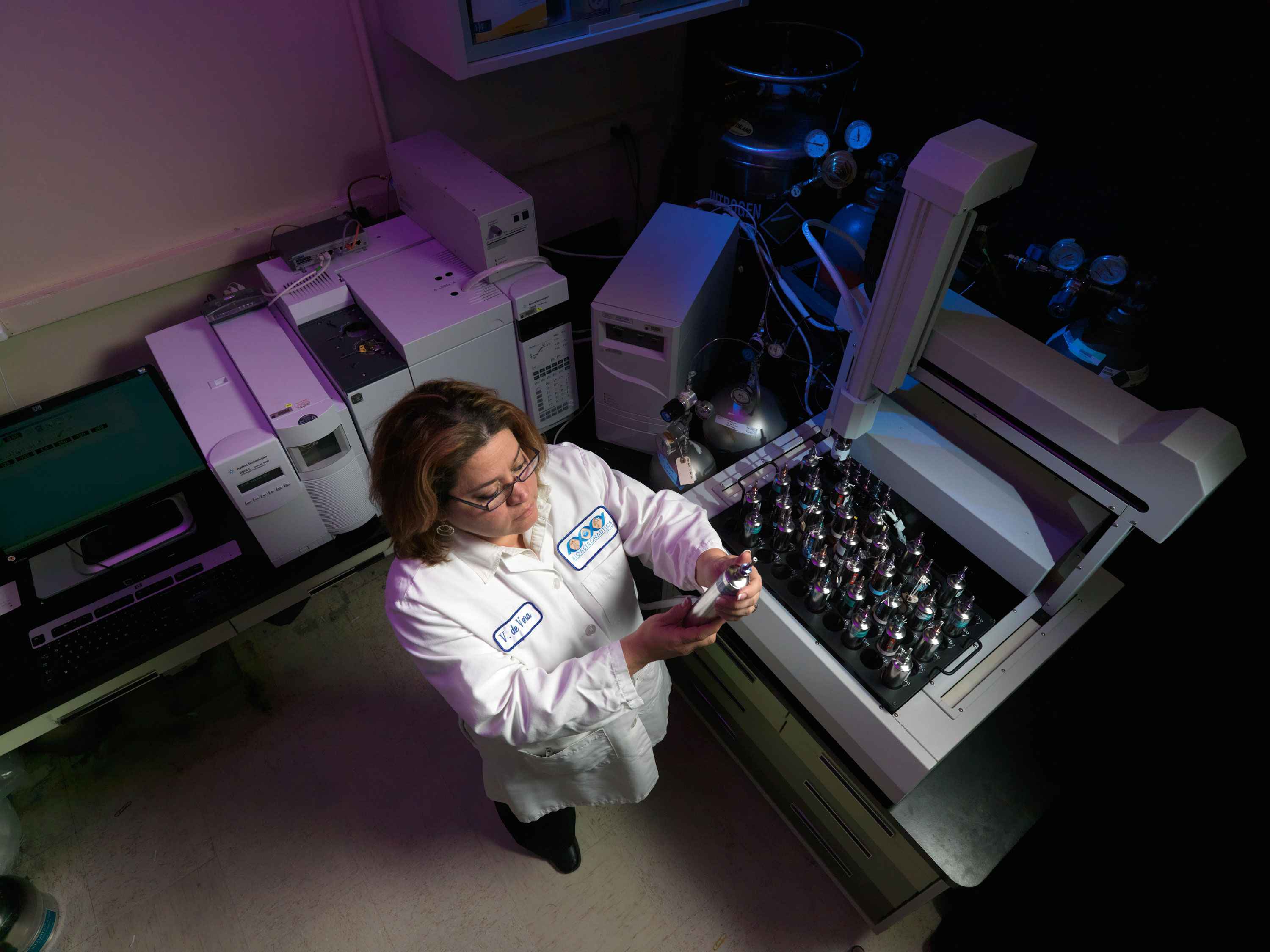
A space toxicologist at NASA JSC.
NASA
Hazardous Materials Summary Tables (HMSTs) are a compilation of the chemical, biological, and flammability hazards of materials on a given flight or mission. HMSTs are required by Safety for all Programs, including but not limited to ISS, Commercial Crew Program (CCP), Multi Purpose Crew Vehicle (MPCV), and Gateway. Johnson Space Center (JSC) toxicologists evaluate the toxic hazard level of all liquids, gases, particles, or gels flown on or to any manned U.S. spacecraft. The biosafety hazard level and flammability levels are assigned by JSC microbiologists and materials experts and are documented in an HMST and in a computerized in-flight version of the HMST called the HazMat (Hazardous Materials) database.
How To Obtain Toxicological Hazard Assessments
“Requirements for Submission of Data Needed for Toxicological Assessment of Chemical and Biologicals to be Flown on Manned Spacecraft”
JSC 27472 (PDF, 766KB) defines the terms “chemicals” and “biological materials” as applied to items being flown on or to any U.S. spacecraft. It explains who must submit information to the JSC toxicologists concerning the materials to be flown and specifies what information is needed. It provides schedules, formats, and contact information.
Additional US requirements for environmental control and life support (ECLS) assessments can be found in JSC 66869 (PDF, 698KB).
Data Submission
For all flights to ISS and all Artemis requests (Orion, Gateway, Human Lander System (HLS)), please submit data via the electronic hazardous materials summary table (eHMST) tool. If you do not have access to this tool, please submit a NAMS request for access to JSC – CMC External Tools. Please reference eHMST training for more information
NOTE: For experimental payloads/hardware planned for launch on a Russian vehicle, stowed and/or operated on the Russian Segment of ISS, or planned for return or disposal on a Russian vehicle, we strongly encourage payload providers to submit biological and chemical data to the Russian Institute for Biomedical Problems (moukhamedieva@imbp.ru OR barantseva@imbp.ru).
Hazard Assessments
Toxicological hazard assessments are conducted according to JSC 26895 – Guidelines for Assessing the Toxic Hazard of Spacecraft Chemicals and Test Materials. The resulting Toxicity Hazard Level (THL) in combination with the BioSafety Level (BSL) and Flammability Hazard Level (FHL) form the basis for the combined Hazard Response Level (HRL) used for labeling and operational response per flight rule B20-16.
Preparations for Next Moonwalk Simulations Underway (and Underwater)
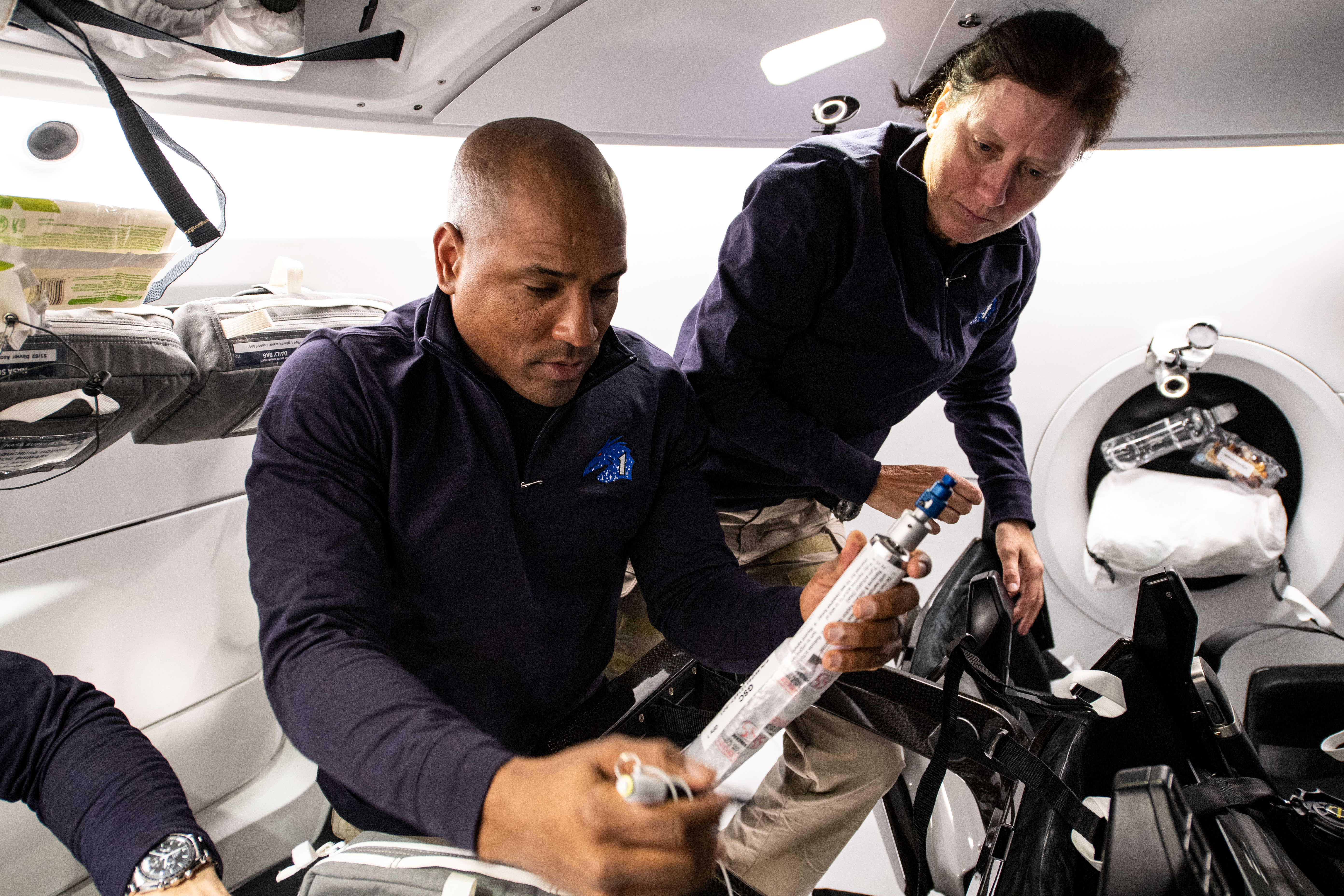
SpaceX Crew-1 Pilot Victor Glover and Mission Specialist Shannon Walker work with a Grab Sample Container (GSC) in the SpaceX Crew Dragon Resilience spacecraft while en route to the ISS.
NASA
Toxicology and Environmental Chemistry (TEC) monitors airborne contaminants in both spacecraft air and water. In-flight monitors are employed to provide real-time insight into the environmental conditions on ISS. Archival samples are collected and returned to Earth for full characterization of ISS air and water.
Real-time in-flight air analytical instruments include the Air Quality Monitors (AQM), carbon dioxide (CO2 monitors), and a compound specific analyzer for combustion products (CSA-CP). Real-time in-flight water monitoring capabilities include the colorimetric water quality monitoring kit (CWQMK) and the ISS total organic carbon analyzer (TOCA).
Post-flight analyses are performed on archival samples of spacecraft air and water obtained at specific times and locations during a mission. Air archival samples are collected using “grab sample containers” (GSC) and formaldehyde badges. The U.S. and Russian water recovery systems on the ISS process atmospheric moisture (U.S. and Russian systems) and urine distillate (U.S. system only) into clean, potable water for the crew to use. The Water Kit is utilized to collect archival samples of the potable water and are routinely returned to the ground to monitor the quality of the water produced by the systems. Samples of condensate and wastewater are also collected and returned to check for the presence of contaminants that could break through the water recovery systems.
Results of Post-Flight Analysis of In-Flight Air Samples (Most Recent First)
Preparations for Next Moonwalk Simulations Underway (and Underwater)
NASA astronaut Jonny Kim floats inside the Cupola of the International Space Station.
NASA
NASA astronaut Jonny Kim is wrapping up his first mission aboard the International Space Station in early December. During his stay, Kim conducted scientific experiments and technology demonstrations to benefit humanity on Earth and advance NASA’s Artemis campaign in preparation for future human missions to Mars.
Here is a look at some of the science Kim completed during his mission:
Medical check-ups in microgravity
NASA
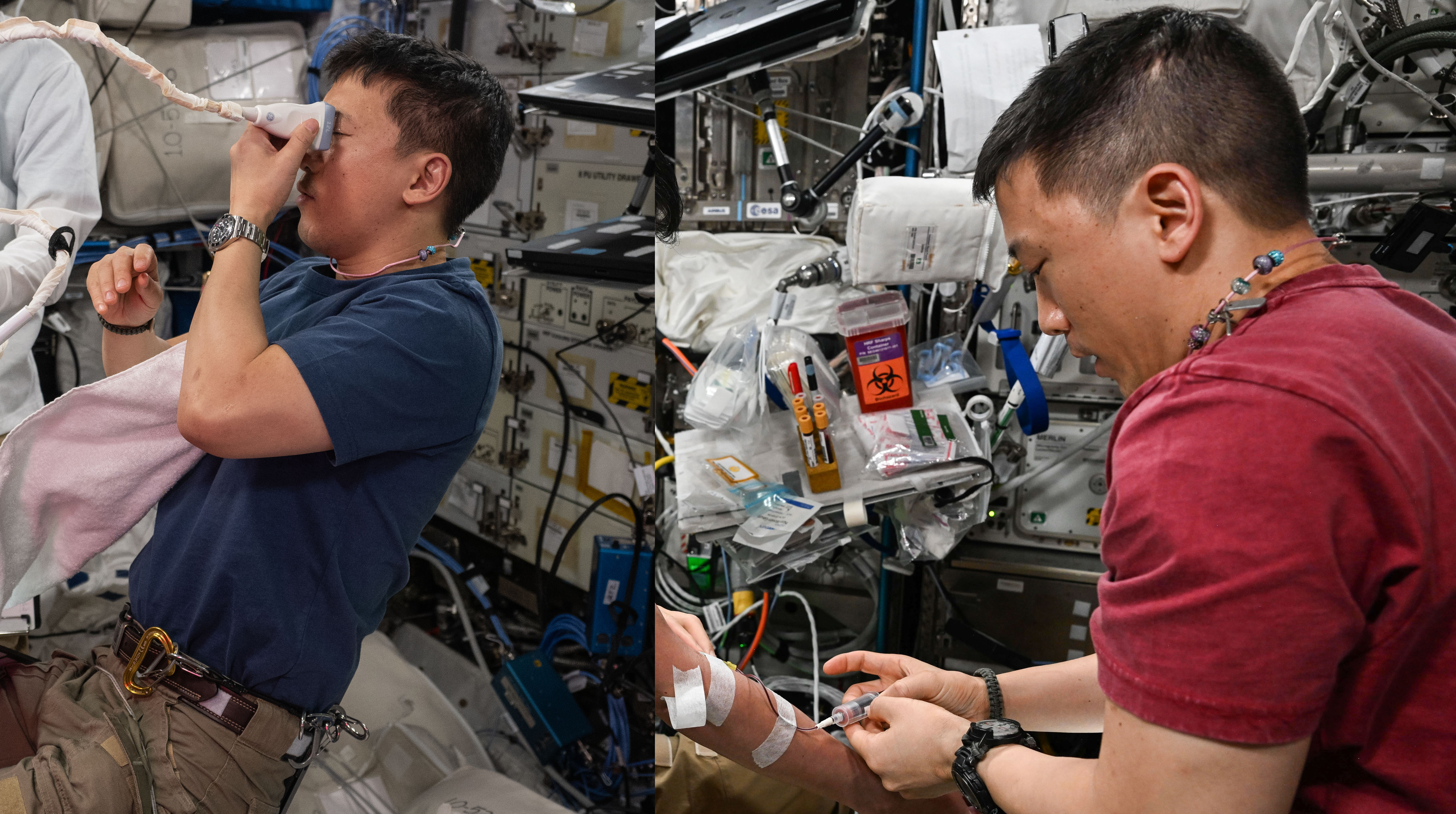
NASA astronaut Jonny Kim, a medical doctor, completed several routine medical exams while aboard the International Space Station. NASA flight surgeons and researchers monitor crew health using a variety of tools, including blood tests, eye exams, and ultrasounds.
Kim conducts an ultrasound of his eye in the left image. Eye exams are essential as long-duration spaceflight may cause changes to the eye’s structure and affect vision, a condition known as spaceflight associated neuro-ocular syndrome, or SANS. In the right image, Kim draws blood from a fellow crew member. These blood sample collections provide important insights into crew cartilage and bone health, cardiovascular function, inflammation, stress, immune function, and nutritional status.
NASA astronauts complete regular medical exams before, during, and after spaceflight to monitor astronaut health and develop better tools and measures for future human exploration missions to the Moon and Mars.
NASA astronaut Jonny Kim photographs dwarf tomato sprouts grown using a nutrient supplement instead of photosynthesis as part of a study on plant development and gene expression. The plants are given an acetate supplement as a secondary nutrition source, which could increase growth and result in better yields, all while using less power and fewer resources aboard the space station and future spacecraft.
NASA astronaut Jonny Kim uses a ham radio to speak with students on Earth via an educational program connecting students worldwide with astronauts aboard the International Space Station. Students can ask about life aboard the orbiting laboratory and the many experiments conducted in microgravity. This program encourages an interest in STEM (science, technology, engineering, and mathematics) and inspires the next generation of space explorers.
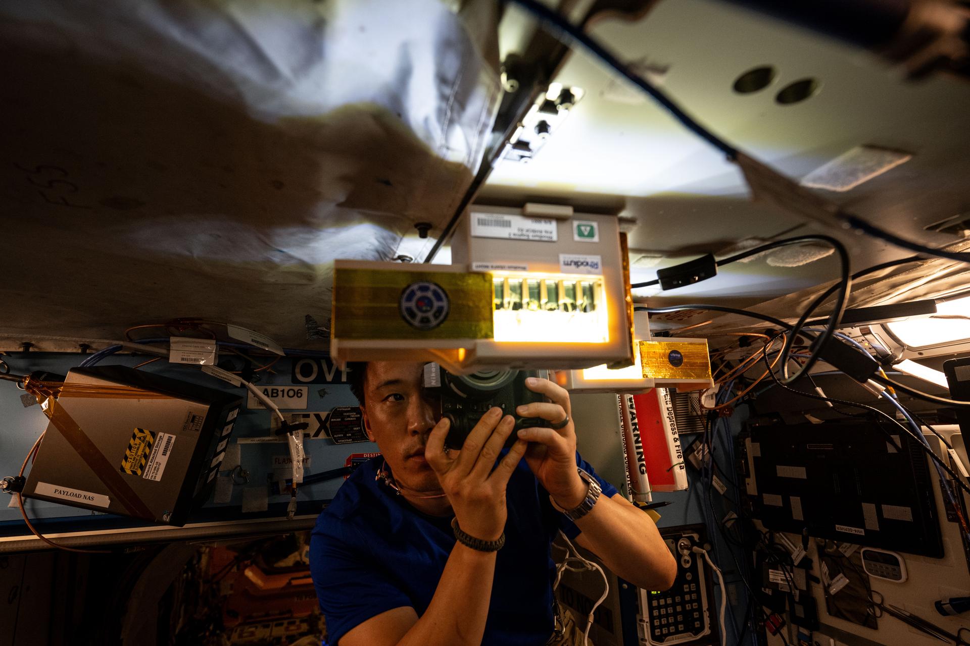
Secure and reliable data storage and transmission are essential to maintain the protection, accuracy, and accessibility of information. In this photo, NASA astronaut Jonny Kim displays research hardware that tests the viability of encoding, transmitting, and decoding encrypted information via DNA sequences. As part of this experiment, DNA with encrypted information is sequenced aboard the space station to determine the impact of the space environment on its stability. Using DNA to store and transmit data could reduce the weight and energy requirements compared to traditional methods used for long-duration space missions and Earth-based industries.
Future deep space exploration could rely on robotics remotely operated by humans. NASA astronaut Jonny Kim tests a technology demonstration that allows astronauts to remotely control robots on Earth from the International Space Station. Findings from this investigation could help fine-tune user-robot operating dynamics during future missions to the Moon, Mars, and beyond.
NASA astronaut Jonny Kim conducts an investigation to assess the effects of microgravity on bone marrow stem cells, including their ability to secrete proteins that form and dissolve bone. Bone loss, an age-related factor on Earth, is aggravated by weightlessness and is a health concern for astronauts. Researchers are evaluating whether blocking signals that cause loss could protect astronauts during long-duration spaceflights. The findings could also lead to preventative measures and treatments for bone loss caused by aging or disease on Earth.
NASA astronaut Jonny Kim tests new hardware installed to an existing crystallization facility that enables increased production of crystals and other commercially relevant materials, like golden nanospheres. These tiny, spherical gold particles have optical and electronic applications, and are biocompatible, making them useful for medication delivery and diagnostics. As part of this experiment aboard the space station, Kim attempted to process larger, more uniform golden nanospheres than those produced on the ground.
Some vitamins and nutrients in foods and supplements lose their potency during long-term storage, and insufficient intake of even a single nutrient can lead to diseases and other health issues. NASA astronaut Jonny Kim displays purple-pink production bags for an investigation aimed at producing nutrient-rich yogurt and kefir using bioengineered yeasts and probiotics. The unique color comes from a food-grade pH indicator that allows astronauts to visually monitor the fermentation process.
NASA astronaut Jonny Kim uses the Microgravity Science Glovebox to study how high-concentration protein fluids behave in microgravity. This study helps researchers develop more accurate models to predict the behavior of these complex fluids in various scenarios, which advances manufacturing processes in space and on Earth. It also can enable the development of next-generation medicines for treating cancers and other diseases.
On Sept. 28, 2025, NASA astronaut Jonny Kim photographed Hurricane Humberto from the International Space Station. Located at 250 miles above Earth, the orbiting laboratory’s unique orbit allows crew members to photograph the planet’s surface including hurricanes, dust storms, and fires. These images are used to document disasters and support first responders on the ground.
NASA is marking America’s 250th year with a bold new symbol of the nation’s relentless drive to explore.
The America 250 emblem is now on the twin solid rocket boosters of the SLS (Space Launch System) rocket for Artemis II — the powerhouse that will launch a crew of four around the Moon next year. Unveiled Tuesday, the design echoes the America 250 Commission’s Spirit of Innovation theme, honoring a country that has never stopped pushing the horizon forward.
At NASA’s Kennedy Space Center in Florida, technicians spent recent weeks carefully applying the emblem on the rocket inside the Vehicle Assembly Building — the same place where rockets for Apollo once stood. Engineers are running final tests on SLS and the Orion spacecraft as preparations intensify for Artemis II.
The roughly 10-day Artemis II journey around the Moon will mark a defining moment in this new era of American exploration — paving the way for U.S. crews to land on the lunar surface and ultimately push onward to Mars.
America’s spirit of discovery is alive, and Artemis is carrying it to the Moon and beyond.
The asteroid Bennu continues to provide new clues to scientists’ biggest questions about the formation of the early solar system and the origins of life. As part of the ongoing study of pristine samples delivered to Earth by NASA’s OSIRIS-REx (Origins, Spectral Interpretation, Resource Identification, and Security-Regolith Explorer) spacecraft, three new papers published Tuesday by the journals Nature Geosciences and Nature Astronomy present remarkable discoveries: sugars essential for biology, a gum-like substance not seen before in astromaterials, and an unexpectedly high abundance of dust produced by supernova explosions.
Sugars essential to life
Scientists led by Yoshihiro Furukawa of Tohoku University in Japan found sugars essential for biology on Earth in the Bennu samples, detailing their findings in the journal Nature Geoscience. The five-carbon sugar ribose and, for the first time in an extraterrestrial sample, six-carbon glucose were found. Although these sugars are not evidence of life, their detection, along with previous detections of amino acids, nucleobases, and carboxylic acids in Bennu samples, show building blocks of biological molecules were widespread throughout the solar system.
For life on Earth, the sugars deoxyribose and ribose are key building blocks of DNA and RNA, respectively. DNA is the primary carrier of genetic information in cells. RNA performs numerous functions, and life as we know it could not exist without it. Ribose in RNA is used in the molecule’s sugar-phosphate “backbone” that connects a string of information-carrying nucleobases.
“All five nucleobases used to construct both DNA and RNA, along with phosphates, have already been found in the Bennu samples brought to Earth by OSIRIS-REx,” said Furukawa. “The new discovery of ribose means that all of the components to form the molecule RNA are present in Bennu.”
The discovery of ribose in asteroid samples is not a complete surprise. Ribose has previously been found in two meteorites recovered on Earth. What is important about the Bennu samples is that researchers did not find deoxyribose. If Bennu is any indication, this means ribose may have been more common than deoxyribose in environments of the early solar system.
Researchers think the presence of ribose and lack of deoxyribose supports the “RNA world” hypothesis, where the first forms of life relied on RNA as the primary molecule to store information and to drive chemical reactions necessary for survival.
A team of Japanese and US scientists have discovered the bio-essential sugars ribose and glucose in samples of asteroid Bennu that were collected by NASA’s OSIRIS-REx mission. This finding builds on the earlier discovery of nucleobases (the genetic components of DNA and RNA), phosphate, and amino acids (the building blocks of proteins) in the Bennu samples, showing that the molecular ingredients of life could have been delivered to early Earth by meteorites. Download this graphic from NASA’s Scientific Visualization Studio website: https://svs.gsfc.nasa.gov/14932
NASA/Goddard/University of Arizona/Dan Gallagher
“Present day life is based on a complex system organized primarily by three types of functional biopolymers: DNA, RNA, and proteins,” explains Furukawa. “However, early life may have been simpler. RNA is the leading candidate for the first functional biopolymer because it can store genetic information and catalyze many biological reactions.”
The Bennu samples also contained one of the most common forms of “food” (or energy) used by life on Earth, the sugar glucose, which is the first evidence that an important energy source for life as we know it was also present in the early solar system.
Mysterious, ancient ‘gum’
A second paper, in the journal Nature Astronomy led by Scott Sandford at NASA’s Ames Research Center in California’s Silicon Valley and Zack Gainsforth of the University of California, Berkeley, reveals a gum-like material in the Bennu samples never seen before in space rocks – something that could have helped set the stage on Earth for the ingredients of life to emerge. The surprising substance was likely formed in the early days of the solar system, as Bennu’s young parent asteroid warmed.
Once soft and flexible, but since hardened, this ancient “space gum” consists of polymer-like materials extremely rich in nitrogen and oxygen. Such complex molecules could have provided some of the chemical precursors that helped trigger life on Earth, and finding them in the pristine samples from Bennu is important for scientists studying how life began and whether it exists beyond our planet.
On this primitive asteroid that formed in the early days of the solar system, we’re looking at events near the beginning of the beginning.
Scott SandFord
Astrophysicist, NASA’s Ames Research Center
Bennu’s ancestral asteroid formed from materials in the solar nebula – the rotating cloud of gas and dust that gave rise to the solar system – and contained a variety of minerals and ices. As the asteroid began to warm, due to natural radiation, a compound called carbamate formed through a process involving ammonia and carbon dioxide. Carbamate is water soluble, but it survived long enough to polymerize, reacting with itself and other molecules to form larger and more complex chains impervious to water. This suggests that it formed before the parent body warmed enough to become a watery environment.
“With this strange substance, we’re looking at, quite possibly, one of the earliest alterations of materials that occurred in this rock,” said Sandford. “On this primitive asteroid that formed in the early days of the solar system, we’re looking at events near the beginning of the beginning.”
Using an infrared microscope, Sandford’s team selected unusual, carbon-rich grains containing abundant nitrogen and oxygen. They then began what Sandford calls “blacksmithing at the molecular level,” using the Molecular Foundry at Lawrence Berkeley National Laboratory (Berkeley Lab) in Berkeley, California. Applying ultra-thin layers of platinum, they reinforced a particle, welded on a tungsten needle to lift the tiny grain, and shaved the fragment down using a focused beam of charged particles.
A microscopic particle of asteroid Bennu, brought to Earth by NASA’s OSIRIS-REx mission, is manipulated under a transmission electron microscope. In order to move the fragment for further analysis, researchers first reinforced it with thin strips of platinum (the “L” shape on the particle’s surface) then welded a tungsten microneedle to it. The asteroid fragment measures 30 micrometers (about one-one thousandth of an inch) across.
NASA/University of California, Berkeley
When the particle was a thousand times thinner than a human hair, they analyzed its composition via electron microscopy at the Molecular Foundry and X-ray spectroscopy at Berkeley Lab’s Advanced Light Source. The ALS’s high spatial resolution and sensitive X-ray beams enabled unprecedented chemical analysis.
“We knew we had something remarkable the instant the images started to appear on the monitor,” said Gainsforth. “It was like nothing we had ever seen, and for months we were consumed by data and theories as we attempted to understand just what it was and how it could have come into existence.”
The team conducted a slew of experiments to examine the material’s characteristics. As the details emerged, the evidence suggested the strange substance had been deposited in layers on grains of ice and minerals present in the asteroid.
It was also flexible – a pliable material, similar to used gum or even a soft plastic. Indeed, during their work with the samples, researchers noticed the strange material was bendy and dimpled when pressure was applied. The stuff was translucent, and exposure to radiation made it brittle, like a lawn chair left too many seasons in the sun.
“Looking at its chemical makeup, we see the same kinds of chemical groups that occur in polyurethane on Earth,” said Sandford, “making this material from Bennu something akin to a ‘space plastic.’”
The ancient asteroid stuff isn’t simply polyurethane, though, which is an orderly polymer. This one has more “random, hodgepodge connections and a composition of elements that differs from particle to particle,” said Sandford. But the comparison underscores the surprising nature of the organic material discovered in NASA’s asteroid samples, and the research team aims to study more of it.
By pursuing clues about what went on long ago, deep inside an asteroid, scientists can better understand the young solar system – revealing the precursors to and ingredients of life it already contained, and how far those raw materials may have been scattered, thanks to asteroids much like Bennu.
Abundant supernova dust
Another paper in the journal Nature Astronomy, led by Ann Nguyen of NASA’s Johnson Space Center in Houston, analyzed presolar grains – dust from stars predating our solar system – found in two different rock types in the Bennu samples to learn more about where its parent body formed and how it was altered by geologic processes. It is believed that presolar dust was generally well-mixed as our solar system formed. The samples had six-times the amount of supernova dust than any other studied astromaterial, suggesting the asteroid’s parent body formed in a region of the protoplanetary disk enriched in the dust of dying stars.
The study also reveals that, while Bennu’s parent asteroid experienced extensive alteration by fluids, there are still pockets of less-altered materials within the samples that offer insights into its origin.
An artistic visualization of the OSIRIS-REx spacecraft descending towards asteroid Bennu to collect a sample.
NASA/Goddard/University of Arizona
“These fragments retain a higher abundance of organic matter and presolar silicate grains, which are known to be easily destroyed by aqueous alteration in asteroids,” said Nguyen. “Their preservation in the Bennu samples was a surprise and illustrates that some material escaped alteration in the parent body. Our study reveals the diversity of presolar materials that the parent accreted as it was forming.”
NASA’s Goddard Space Flight Center provided overall mission management, systems engineering, and the safety and mission assurance for OSIRIS-REx. Dante Lauretta of the University of Arizona, Tucson, is the principal investigator. The university leads the science team and the mission’s science observation planning and data processing. Lockheed Martin Space in Littleton, Colorado, built the spacecraft and provided flight operations. Goddard and KinetX Aerospace were responsible for navigating the OSIRIS-REx spacecraft. Curation for OSIRIS-REx takes place at NASA’s Johnson Space Center in Houston. International partnerships on this mission include the OSIRIS-REx Laser Altimeter instrument from CSA (Canadian Space Agency) and asteroid sample science collaboration with JAXA’s (Japan Aerospace Exploration Agency’s) Hayabusa2 mission. OSIRIS-REx is the third mission in NASA’s New Frontiers Program, managed by NASA’s Marshall Space Flight Center in Huntsville, Alabama, for the agency’s Science Mission Directorate in Washington.
For more information on the OSIRIS-REx mission, visit:
On Nov. 2, 2025, NASA honored 25 years of continuous human presence aboard the International Space Station. What began as a fragile framework of modules has evolved into a springboard for international cooperation, advanced scientific research and technology demonstrations, the development of a low Earth orbit economy, and NASA’s next great leaps in exploration, including crewed missions to the Moon and Mars.
The first expedition
The Expedition One crew in the Zvezda Service module aboard the International Space Station. From left: commander William Shepherd, Soyuz commander Yuri Gidzenko and Flight Engineer Sergei Krikalev.
NASA
This legacy of achievement in global human endeavors began with the first crew’s arrival to the space station on Nov. 2, 2000. Expedition 1 crew members NASA astronaut William M. Shepherd and Russian Aviation and Space Agency, now Roscosmos, cosmonauts Yuri P. Gidzenko and Sergei K. Krikalev launched from the Baikonur Cosmodrome in Kazakhstan two days prior. After a successful docking, the crew transferred aboard the station and began bringing it to life. Their primary tasks during their four-month mission included installing and activating the life support and communications systems and working with three visiting space shuttle crews to continue the station’s assembly. The trio returned to Earth in March 2001 aboard space shuttle Discovery, after having turned the station over to the Expedition 2 crew.
(Space)walking into history
NASA astronaut Andrew Morgan conducts a spacewalk at the Port- 6 truss structure work site to upgrade International Space Station systems.
NASA/Christina Koch
Assembly and maintenance of the International Space Station would not be possible without the skilled work of crew members performing intricate tasks, in bulky spacesuits, in the harsh environment of space. In addition to station upkeep, spacewalks provide a platform for testing and improving spacesuits and tools – critical information for future exploration of the Moon and Mars. Other spacewalks have included operations for scientific research. In Jan. 2025, for example, crew members collected samples for an investigation examining whether microorganisms have exited through station vents and can survive in space, to better inform spacecraft design that helps prevent human contamination of Mars and other destinations.
More than 270 spacewalks dedicated to the space station have been accomplished in the last quarter century. Several made station and human spaceflight history:
May 1999: NASA astronaut Tamara Jernigan became the first woman to complete a spacewalk at the space station, in support of its construction.
September 2000: Also during space station assembly, NASA astronaut Edward T. “Ed” Lu and Roscosmos cosmonaut Yuri I. Malenchenko conducted the first U.S.-Russian spacewalk.
March 10, 2001: NASA astronauts James Voss and Susan Helms set the record for longest spacewalk in U.S. history, at 8 hours and 56 minutes.
First spacewalks by international partners included:
April 2001 – Canadian Space Agency astronaut Chris Hadfield
July 2005 – Japan Aerospace Exploration Agency astronaut Soichi Noguchi
Aug. 2006 – European Space Agency astronaut Thomas Reiter
Feb. 26, 2004: NASA astronaut Mike Foale and Russian cosmonaut Aleksandr Y. Kaleri complete the first spacewalk with no one inside the station.
Oct. 18, 2019: The first all-female spacewalk in history, conducted by NASA astronauts Christina Koch and Jessica Meir.
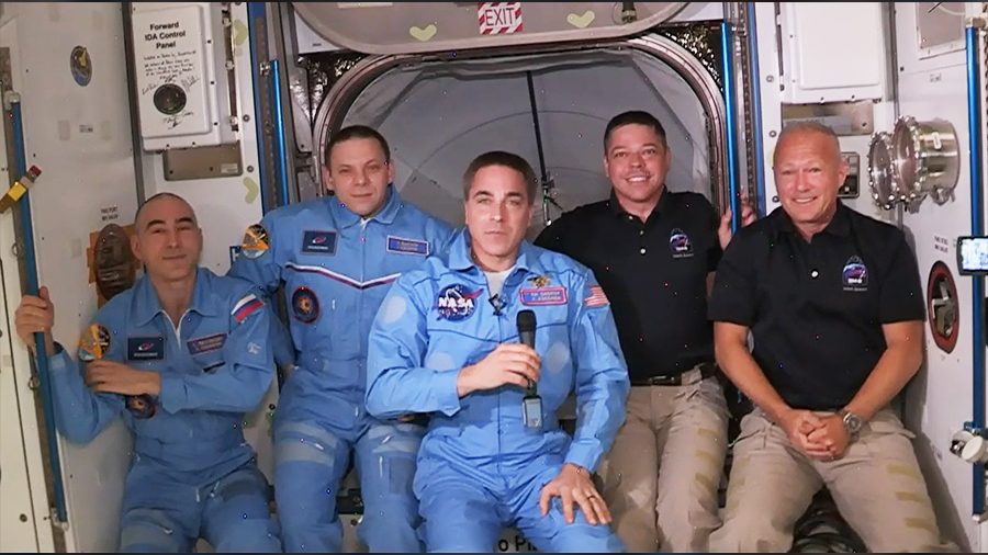
Orbiting laboratory welcomes first commercial crew
The Expedition 63 crew expanded to five members with the arrival of NASA’s SpaceX Crew Dragon on May 31, 2020. From left: Anatoly Ivanishin, Ivan Vagner, Chris Cassidy, Bob Behnken and Doug Hurley.
NASA
The International Space Station welcomed its first commercial crew members on May 31, 2020, when former NASA astronauts Robert Behnken and Douglas Hurley joined Expedition 63 Commander and NASA astronaut Chris Cassidy and Roscosmos cosmonauts Anatoly Ivanishin and Ivan Vagner aboard the orbiting laboratory.
Behnken and Hurley lifted off from Kennedy Space Center in Florida the day before on NASA’s SpaceX Demo-2 test flight – the first launch of American astronauts from U.S. soil since the space shuttle’s retirement in 2011.
The duo quickly integrated with the rest of the crew and participated in a number of scientific experiments, spacewalks, and public engagement events during their 62 days aboard station. Overall, the pair spent 64 days in orbit, completed 1,024 orbits around Earth, and contributed more than 100 hours of time to supporting the orbiting laboratory’s investigations before splashing down on Aug. 2.
Successful completion of the Demo-2 mission paved the way for regular SpaceX flights carrying astronauts to and from the space station. With another certified crew transportation system in place, the International Space Station Program added research time and increased the opportunity for discovery aboard humanity’s testbed for exploration, including preparations for human exploration of the Moon and Mars.
Frank Rubio’s record-breaking year in space
NASA astronaut and Expedition 68 Flight Engineer Frank Rubio inside the cupola, the International Space Station’s “window to the world,” as the orbiting laboratory flew 263 miles above southeastern England on Oct. 1, 2022.
NASA/Frank Rubio
On Sept. 27, 2023, NASA astronaut Frank Rubio returned to Earth after spending 371 days aboard the International Space Station—the longest single spaceflight by a U.S. astronaut in history. His mission surpassed the previous record of 355 days, set by NASA astronaut Mark Vande Hei, and provided scientists with an unprecedented look at how the human body adapts to more than a year in microgravity.
Rubio’s record-setting mission supported six human research studies, including investigations into diet, exercise, and overall physiology and psychology. He was the first astronaut to test whether limited workout equipment could still maintain health and fitness, an important consideration for future spacecraft with tighter living quarters. He also contributed biological samples, surveys, and tests for NASA’s Spaceflight Standard Measures, a study that collects health data from astronauts to better understand how the body adapts to space—knowledge that helps prepare crews for the Artemis campaign to the Moon and future trips to Mars.
Alongside his fellow crew members, Rubio participated in dozens of investigations and technology demonstrations, from growing tomato plants with hydroponic and aeroponic techniques to materials science experiments that advance spacecraft design.
Long-duration missions help inform future spaceflight and lay the groundwork for the next era of human exploration.
A global foundation for growing a low Earth orbit economy
Facilities around the world support the operation and management of the International Space Station.
NASA
The space station is one of the most ambitious international collaborations ever attempted.It brings together international flight crews, multiple launch vehicles, globally distributed launch and flight operations, training, engineering, and development facilities, communications networks, and the international scientific research community for the benefit of all humanity.
An international partnership of space agencies operates the elements of the orbiting laboratory: NASA, Roscosmos, ESA (European Space Agency), JAXA (Japan Aerospace Exploration Agency), and CSA (Canadian Space Agency). Each partner takes primary responsibility for managing and running the station hardware it provides, as well as on-Earth construction, launch support, mission operations, communications, and research and technology facilities that support the station.
At least 290 individuals representing 26 countries, and the five international partners have visited the orbiting laboratory during its 25 years of continuous human presence. Some of those visitors flew to the station on private astronaut missions. These missions contribute to scientific, outreach, and commercial activities. They also help demonstrate the demand for future commercial space stations and are an important component of NASA’s strategy for enabling a robust and competitive commercial economy in low Earth orbit.
The results of the international partnership created through the space station and its accomplishments exemplifies how countries can work together to overcome complex challenges and achieve collaborative goals.
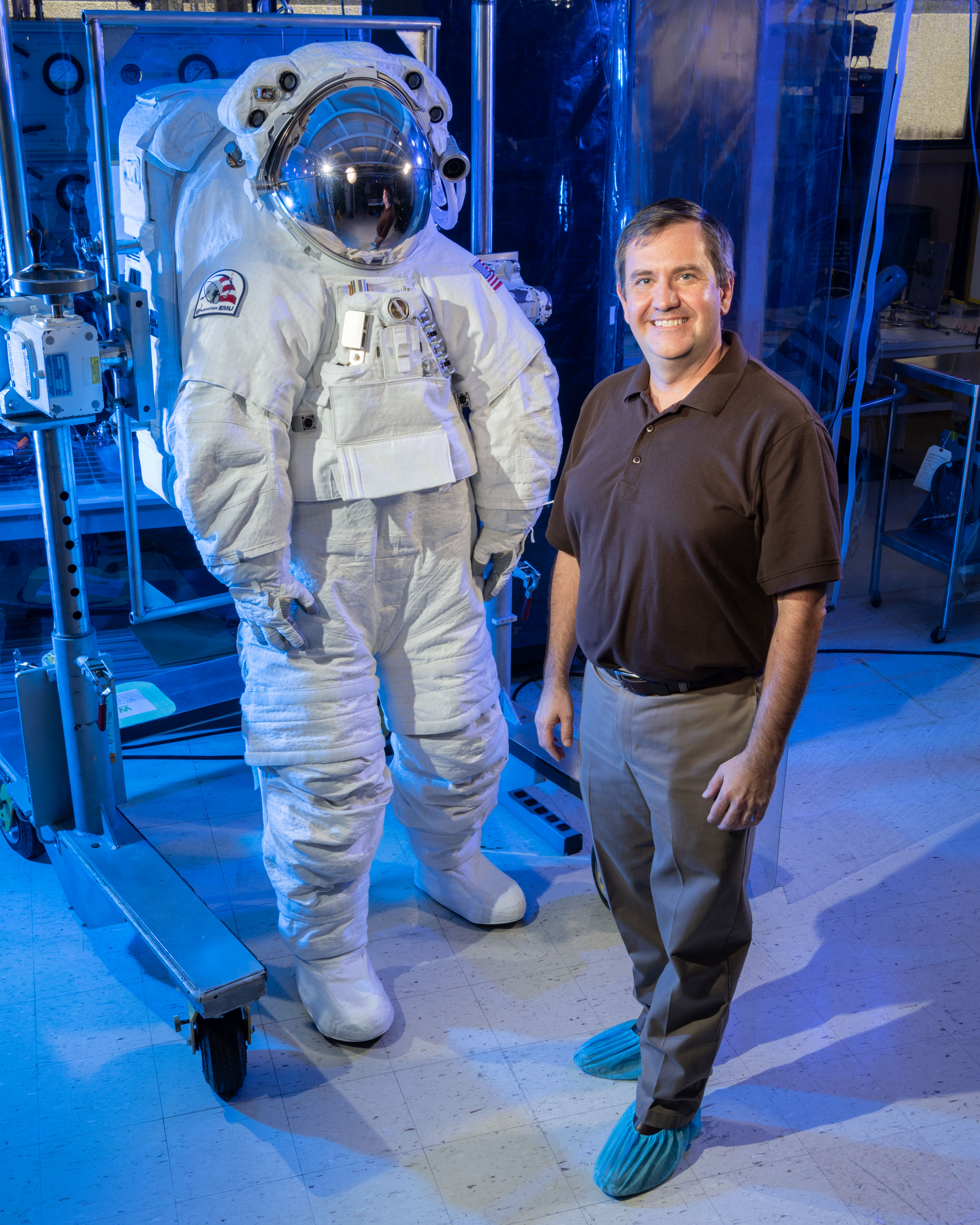
For more than 25 years, Mark Elder has helped make human spaceflight safe and possible. As the International Space Station EVA hardware manager in the Extravehicular Activity (EVA) Office within the EVA and Human Surface Mobility Program, he leads the team responsible for the spacesuits, tools, and logistics that keep astronauts protected during spacewalks—and ensures NASA is ready for the next era of Artemis exploration.
Mark Elder with NASA’s Exploration Extravehicular Mobility Unit (xEMU) spacesuit at Johnson Space Center in Houston.
NASA/Bill Stafford
His team is programmatically responsible for the Extravehicular Mobility Unit, or EMU, spacesuit. That means every bolt, bearing, and battery astronauts rely on outside the International Space Station ultimately falls under their watch. He also oversees the EVA Space Operations Contract, which provides engineering and technical support to keep spacesuit systems flight ready.
Elder’s work directly supports every EVA, or spacewalk, conducted at the station. His team coordinates with astronauts, engineers, and the Mission Control Center in Houston to make sure the suits and tools operate reliably in the most unforgiving environment imaginable. Their work helps ensure every EVA is conducted safely and successfully.
Elder’s passion for NASA began at an early age.
“When I was little, my parents gave me a book called ‘The Astronauts,’” he said. “It had drawings of a reusable spacecraft—the space shuttle—and I fell in love with it. From then on, I told everyone I was going to work at NASA.”
That dream took off at age 16, when he attended Space Academy in Huntsville, Alabama. “That cemented my dream of someday working at NASA, and it taught me a little bit more about the different roles within the agency,” he said.
While attending Case Western Reserve University as a mechanical engineering student, he learned about a new NASA program that allowed college students to design and build an experiment and then come to Johnson Space Center for a week to fly with their experiment on the Boeing KC-135 Stratotanker. “I jumped on the chance to be part of the team,” he said. “The experience further cemented my dream of working at NASA one day—Johnson in particular.”
After graduation, Elder worked with Pratt & Whitney on jet engines. While the experience was invaluable, he knew his heart belonged in human spaceflight. “I learned that one of Pratt’s fellow companies under the United Technologies umbrella was Hamilton Sundstrand, which was the prime contractor for the spacesuit,” he said. “I jumped at the chance to transfer, and my career at NASA finally began.”
Elder spent his first three years at Johnson performing tool-to-tool fit checks on spacewalking equipment, giving him hands-on experience with nearly every tool that he would eventually become responsible for as a hardware manager.
Mark Elder stands in front of the Space Shuttle Atlantis before the STS-117 launch on June 8, 2007.
His early years coincided with the shuttle return-to-flight era, when he worked on reinforced carbon-carbon panel repairs and thermal protection systems. Those experiences built his technical foundation and prepared him for the leadership roles to come.
Over time, Elder took on increasingly complex assignments, eventually leading the team that developed the EVA Long Life Battery—the first human-rated lithium battery used in space. His team created a rigorous test plan to certify the battery for human spaceflight at a time when lithium batteries were under scrutiny for safety concerns.
“Finally signing the certification paperwork was satisfying, but watching an EVA powered by the batteries provided a great sense of pride,” he said.
This innovation set the stage for future generations of even safer, higher-capacity batteries that power today’s spacewalking operations and will eventually support lunar surface activities.
Looking back, Elder said some of his greatest lessons came from learning how to lead with purpose. “The great thing about NASA is the highly motivated and dedicated workforce,” he said. “When I first became a team lead, I thought success meant making quick decisions and moving fast. I learned that leadership is really about listening. Strong teams are built on trust and open communication.”
Another defining lesson, he said, has been learning to assume positive intent. “In a place like NASA, everyone is deeply passionate about what they do,” he said. “It’s easy to misinterpret a disagreement as opposition, but when you remember that everyone is working toward the same goal, the conversation changes. You focus on solving problems, not winning arguments.”
That mindset has guided Elder through some of NASA’s most complex programs and helped him build lasting partnerships across the agency.
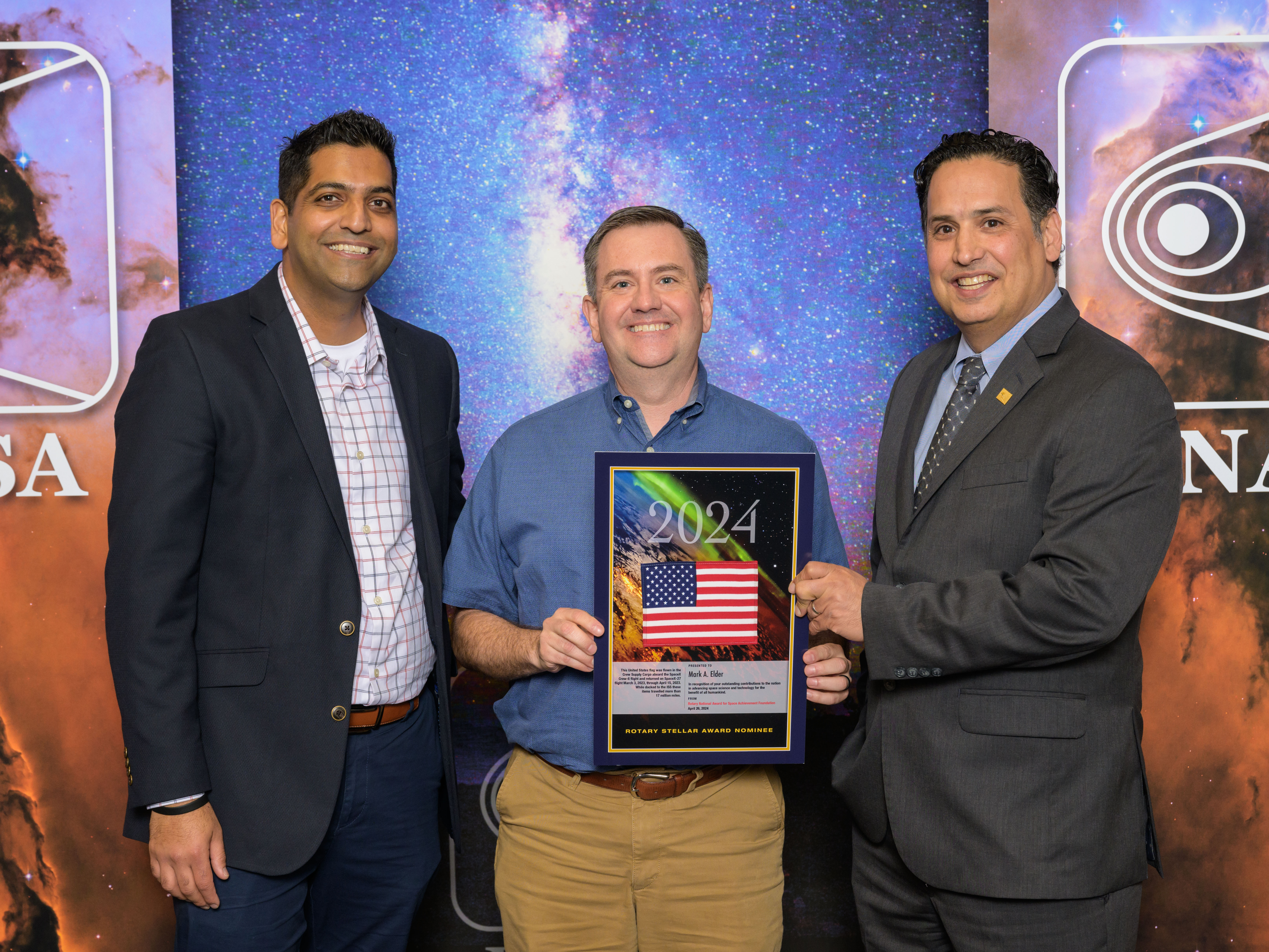
Mark Elder receives an award at the 2024 Rotary National Award for Space Achievement Stellar Awards ceremony at the Hyatt Regency in downtown Houston.
NASA/Josh Valcarcel
Today, Elder’s work extends beyond the orbiting laboratory. As NASA prepares for Artemis missions to the Moon, his team’s experience maintaining and improving the EMU informs the design of next-generation exploration suits.
“The foundation we’ve built on the space station is critical for the future,” he said. “Every tool we’ve refined, every system we’ve upgraded—it all feeds into how we’ll operate on the lunar surface and eventually on Mars.”
Elder believes that the key to future success lies in perseverance. He advises the next generation to never stop dreaming. “My path wasn’t direct, and it would have been easy for me to give up,” he said. “But dreams have a way of guiding you if you don’t let go of them.”
When he’s not supporting those missions, Elder’s creativity takes shape in his workshop. “In my spare time, I love woodworking,” he said. “Building something useful from a pile of rough-sawn boards helps calm me and gives me a great sense of accomplishment. I love being able to build furniture for my family,” he added, after recently finishing a desk for his youngest son.
The same patience and precision he brings to woodworking defines his approach to exploration—steady progress, careful craftmanship, and attention to detail. “As NASA goes to the Moon and Mars, there will be challenges,” Elder said. “As long as we keep dreaming, we will see the next generation walking on the Moon and heading to Mars.”
Preparations for Next Moonwalk Simulations Underway (and Underwater)
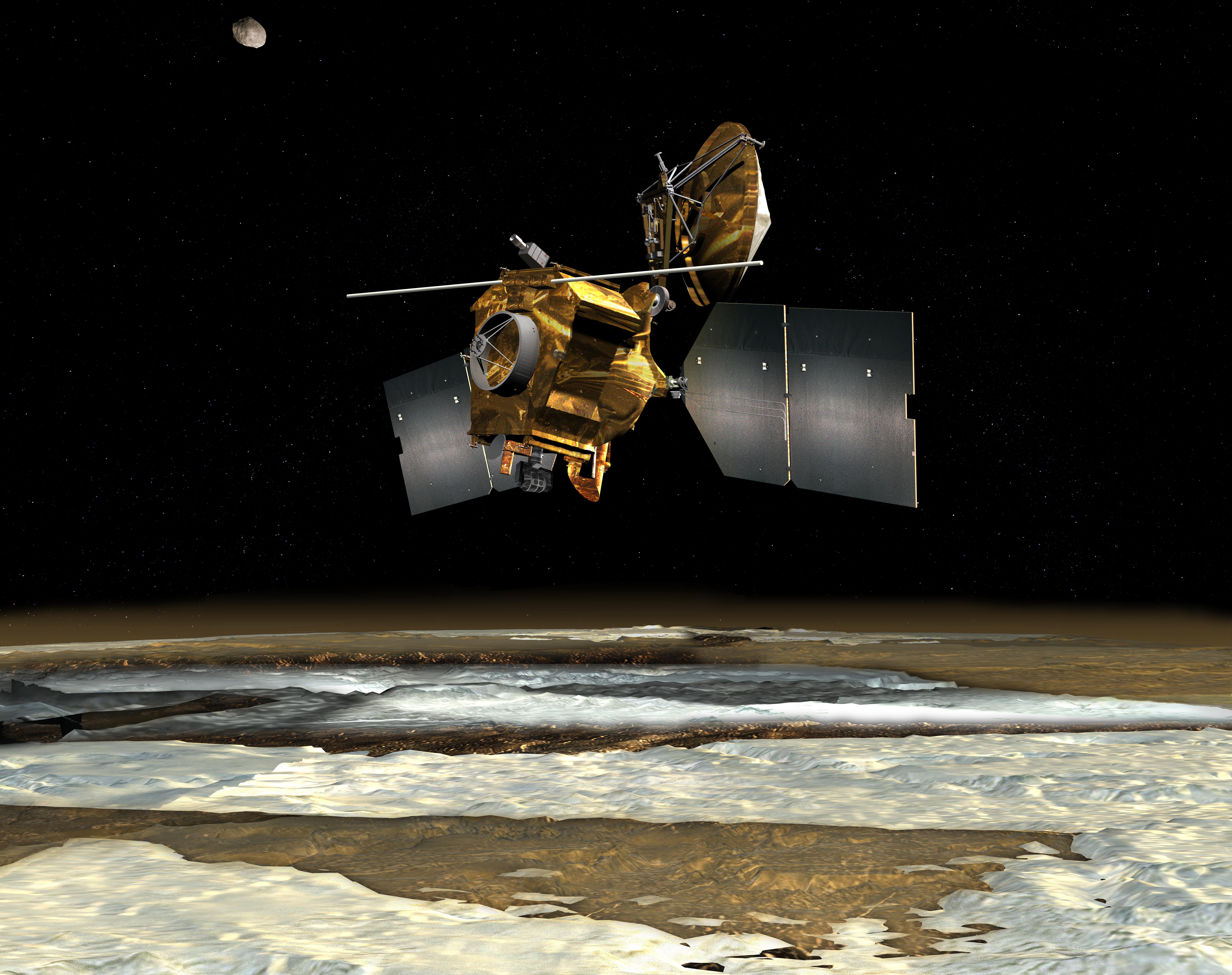
The European Space Agency’s Mars Express orbiter captured this view of Mars’ south polar ice cap Feb. 25, 2015. Three years later, the spacecraft detected a signal from the area to the right of the ice cap that scientists interpreted as an underground lake.
ESA/DLR/FU Berlin, CC BY-SA 3.0 IGO
Results from an enhanced radar technique have demonstrated improvement to sub-surface observations of Mars.
NASA’s Mars Reconnaissance Orbiter (MRO) has revisited and raised new questions about a mysterious feature buried beneath thousands of feet of ice at the Red Planet’s south pole. In a recent study, researchers conclude from data obtained using an innovative radar technique that an area on Mars suspected of being an underground lake is more likely to be a layer of rock and dust.
The 2018 discovery of the suspected lake set off a flurry of scientific activity, as water is closely linked with life in the solar system. While the latest findings indicate this feature is not a lake below the Martian surface, it does suggest that the same radar technique could be used to check for subsurface resources elsewhere on Mars, supporting future explorers.
The paper, published in Geophysical Research Letters on Nov. 17, was led by two of MRO’s Shallow Radar (SHARAD) instrument scientists, Gareth Morgan and Than Putzig, who are based at the Planetary Science Institute in Tucson, Arizona, and Lakewood, Colorado, respectively.
The observations were made by MRO with a special maneuver that rolls the spacecraft 120 degrees. Doing so enhances the power of SHARAD, enabling the radar’s signal to penetrate deeper underground and provide a clearer image of the subsurface. These “very large rolls” have proved so effective that scientists are eager to use them at previously observed sites where buried ice might exist.
This map shows the approximate area where in 2018 ESA’s Mars Express detected a signal the mission’s scientists interpreted as an underground lake. The red lines show the path of NASA’s Mars Reconnaissance Orbiter, which flew both directly overhead as well as over an adjacent region.
Credit: Planetary Science Institute
Morgan, Putzig, and fellow SHARAD team members had made multiple unsuccessful attempts to observe the area suspected of hosting a buried lake. Then the scientists partnered with the spacecraft’s operations team at NASA’s Jet Propulsion Laboratory in Southern California, which leads the mission, to develop the very large roll capability.
Because the radar’s antenna is at the back of MRO, the orbiter’s body obstructs its view and weakens the instrument’s sensitivity. After considerable work, engineers at JPL and Lockheed Martin Space in Littleton, Colorado, which built the spacecraft and supports its operations, developed commands for a 120-degree roll — a technique that requires careful planning to keep the spacecraft safe — to direct more of SHARAD’s signal at the surface.
Bright signal
On May 26, SHARAD performed a very large roll to finally pick up the signal in the target area, which spans about 12.5 miles (20 kilometers) and is buried under a slab of water ice almost 1 mile (1,500 meters) thick.
When a radar signal bounces off underground layers, the strength of its reflection depends on what the subsurface is made of. Most materials let the signal slip through or absorb it, making the return faint. Liquid water is special in that it produces a very reflective surface, sending back a very strong signal (imagine pointing a flashlight at a mirror).
That’s the kind of signal that was spotted from this area in 2018 by a team working with the Mars Advanced Radar for Subsurface and Ionospheric Sounding (MARSIS) instrument aboard the ESA (European Space Agency) Mars Express orbiter. To explain how such a body of water could remain liquid under all that ice, scientists have hypothesized it could be a briny lake, since high salt content can lower water’s freezing temperature.
An antenna sticks out like whiskers from NASA’s Mars Reconnaissance Orbiter in this artist’s concept depicting the spacecraft, which has been orbiting the Red Planet since 2006. This antenna is part of SHARAD, a radar that peers below the Martian surface.
NASA/JPL-Caltech
“We’ve been observing this area with SHARAD for almost 20 years without seeing anything from those depths,” said Putzig. But once MRO achieved a very large roll over the precise area, the team was able to look much deeper. And rather than the bright signal MARSIS received, SHARAD detected a faint one. A different very-large-roll observation of an adjacent area didn’t detect a signal at all, suggesting something unique is causing a quirky radar signal at the exact spot MARSIS saw a signal.
“The lake hypothesis generated lots of creative work, which is exactly what exciting scientific discoveries are supposed to do,” said Morgan. “And while this new data won’t settle the debate, it makes it very hard to support the idea of a liquid water lake.”
Alternative explanations
Mars’ south pole has an ice cap sitting atop heavily cratered terrain, and most radar images of the area below the ice show lots of peaks and valleys. Morgan and Putzig said it’s possible that the bright signal MARSIS detected here may just be a rare smooth area — an ancient lava flow, for example.
Both scientists are excited to use the very large roll technique to reexamine other scientifically interesting regions of Mars. One such place is Medusae Fossae, a sprawling geologic formation on Mars’ equator that produces little radar return. While some scientists have suggested it’s composed of layers of volcanic ash, others have suggested the layers may include heaps of ice deep within.
“If it’s ice, that means there’s lots of water resources near the Martian equator, where you’d want to send humans,” said Putzig. “Because the equator is exposed to more sunlight, it’s warmer and ideal for astronauts to live and work.”
More about MRO
NASA’s Jet Propulsion Laboratory in Southern California manages MRO for the agency’s Science Mission Directorate in Washington as part of NASA’s Mars Exploration Program portfolio. Lockheed Martin Space in Denver built MRO and supports its operations. SHARAD was provided to the MRO mission by the Italian Space Agency (ASI).
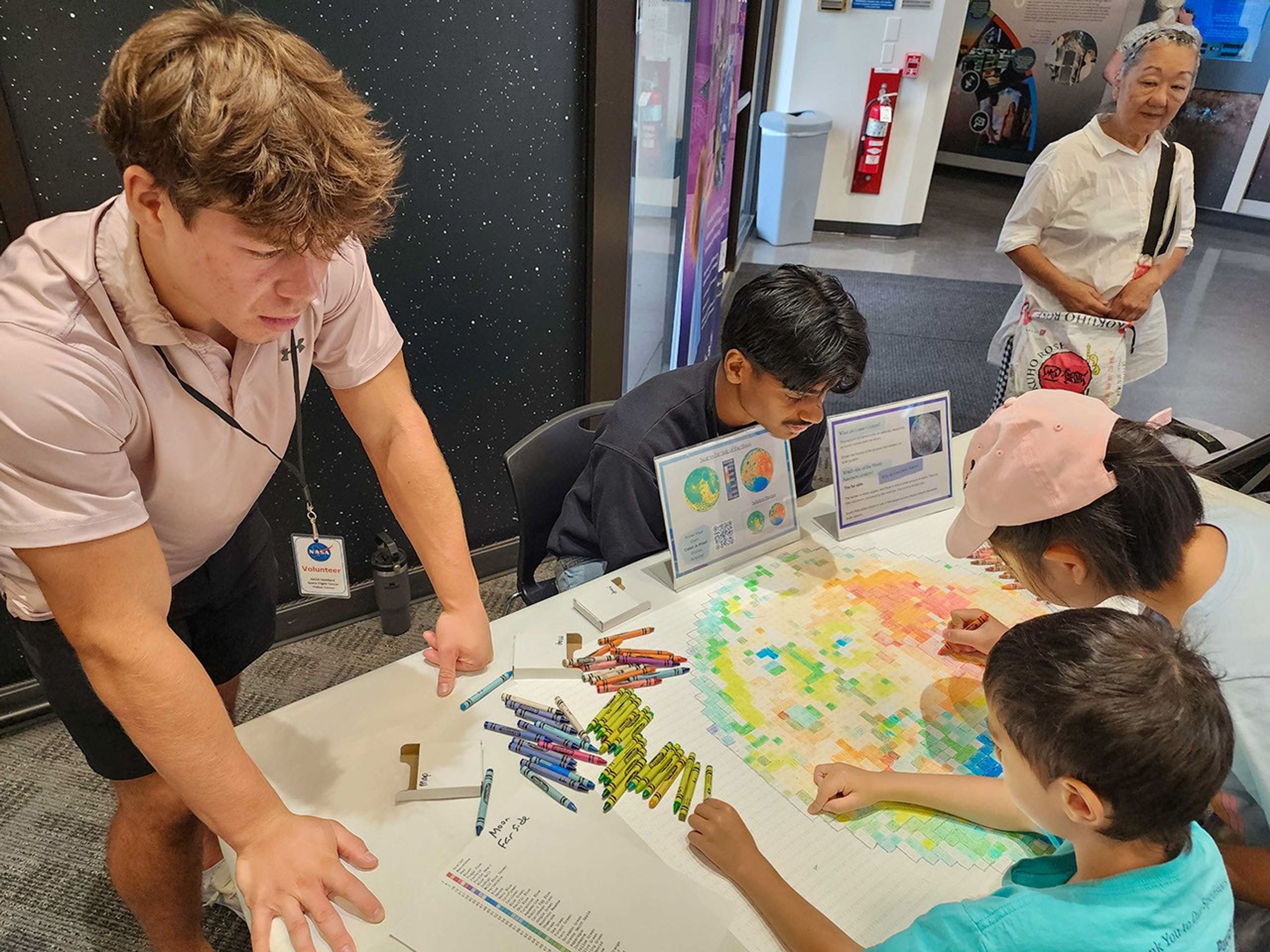
NASA Fuels Discovery from Earth to Sky: One Crayon at a Time
Student interns help kids color in data to learn more about the far side of the Moon while visiting the Goddard Space Flight Center Visitor Center.
Photo Credit: NASA Earth to Sky
A collaboration between the NASA Earth Science Education Collaborative (NESEC) and Earth to Sky (ETS) – an exciting, growing partnership between NASA, the National Park Service, and other federal, state, and local organizations – is facilitating the implementation of a simple, yet incredibly effective activity that will help millions of national park visitors connect with NASA Earth and space science.
The Color-a-Pixel activity, developed by NESEC, transforms complex satellite imagery into accessible, collaborative art projects. Incorporating this simple technique into ETS science communication training programs demonstrates to park interpreters and outdoor educators how NASA’s view from space can enhance millions of visitor experiences at parks, refuges, and nature centers.
“This low-tech activity is powerful because of its simplicity,” explains ETS Space Science Coordinator Brandi Stewart, “All you have to do is pick up a crayon, follow the easy number guides, and discover the stories that NASA satellites are telling us about our world and beyond.”
The Color-a-Pixel activity begins with selecting satellite imagery from NASA missions like Landsat, the Mars Reconnaissance Orbiter (MRO), or the Lunar Reconnaissance Orbiter (LRO). Using technology developed by NESEC’s lead organization, the Institute for Global Environmental Strategies, these images are converted into a 3’ by 2’ poster of numbered squares, each corresponding to one of 120 standard Crayola crayon colors.
Earth to Sky demonstrates the magnetic appeal of this activity by setting it up for the rangers and educators during workshops. With a bit of explanation, participants immediately jump in, eager to reveal the imagery and data shown through the pixels.
“It becomes a group mission that, by the end of the training, the image will be fully colored in and complete. It’s been a great teambuilding and stress-relieving activity for our participants,” states Geneviève de Messières, Earth to Sky Program Lead.
When applied to public lands communication efforts, this activity becomes a tool for interpretive messaging. While visitors work on completing the image, park rangers can weave in scientific concepts, environmental change stories, and space exploration connections. This activity also drives home that satellite imagery is more than just a pretty picture – each pixel is also data that scientists use to better understand Earth and other worlds throughout our solar system.
Bringing Space Down to Earth
Some ways that Earth to Sky has implemented the activity at special events on public lands include:
Death Valley Dark Sky Festival, California: Visitors were invited to color Landsat imagery of Earth’s Badwater Basin and MRO imagery of Mars’ Belva Crater. As they colored, Earth to Sky outreach specialists made connections between finding signs of water on the dry landscapes in both locations.
Park After Dark, Minnesota: During this urban event hosted by Mississippi River & National Recreation Area in Minneapolis St. Paul, attendees worked together to color topographical maps of both the Moon’s familiar near side and its mysterious far side, using data from NASA’s Lunar Reconnaissance Orbiter. The striking differences that emerged through their coloring sparked questions about why the Moon’s two hemispheres appear so dramatically different, leading to rich discussions about lunar formation and geological change.
Patuxent Wildlife Refuge Open House, Maryland: Just miles from the urban centers of Baltimore and Washington DC, the Color-a-Pixel activity helped local community members visualize something they could feel but not easily see: the refuge’s role as a “cool island” in an urban heat landscape. Visitors colored Landsat imagery of the refuge and surrounding neighborhoods while examining heat maps showing temperature differences between developed areas and the protected green space. The activity helped residents understand the refuge’s importance beyond wildlife habitat.
The collaboration between NESEC and Earth to Sky brings complex scientific concepts to diverse audiences in engaging and relevant ways. Earth to Sky’s community of practice –now including more than 2,000 interpreters and environmental educators – reaches millions of visitors annually across the country’s parks, refuges, and nature centers.
Theresa Schwerin, who leads NESEC, noted that Color-a-Pixel originally started as a simple idea for a tabletop activity to use at conferences and public events. “I wanted something hands-on that could draw people in and start conversations as simple as ‘these beautiful NASA images from space are data’ and talk about different NASA missions and how they are relevant to people’s lives. There’s also an opportunity to invite the public to contribute to NASA science by participating in citizen science projects … [some of which] can fill in the details of the pixels with information that complements NASA’s view from space.”
Andrew Clark, a data scientist and engineer at IGES, created the Color-a-Pixel poster generator, which has gone through several iterations to make it more effective. Schwerin noted, “I’ve used this at several public events. Kids will jump right in, with parents watching over their shoulders. Soon enough, the entire family is coloring together and asking questions about the image and NASA. I am thrilled about our collaboration with Earth to Sky that is taking this even further.”
As environmental challenges increasingly affect public lands, this collaboration helps visitors understand these issues through NASA’s unique perspective from above. The activity also introduces learners of all ages to the broader value of NASA’s Earth science missions alongside its more well-known space exploration endeavors.
Continuing to Color Outside the Lines
Looking ahead, the Earth to Sky partnership plans to continue using this activity in each new place they host a training. Most recently, Earth to Sky shared the activity with 417 visitors to the Goddard Space Flight Center Visitor Center, where local families colored in topographical Moon maps to prepare for International Observe the Moon Night. Additionally, a recording of a recent Color-a-Pixel webinar with NESEC’s Theresa Schwerin is available on the Earth to Sky website for interpreters and informal educators interested in implementing this place-based activity. Free registration is required to access this (and dozens of other) webinar recordings.
The success of this collaboration demonstrates how seemingly simple activities – enhanced with NASA science – can create meaningful learning experiences that resonate with visitors long after they leave a park or refuge.
For interpreters, educators, or NASA enthusiasts interested in bringing the Color-a-Pixel activity to their own sites or events, pre-generated activities are available in the gallery at: https://strategies.org/color-a-pixel-pregenerated.
NASA science is helping humanity discover new perspectives on both our home planet and the universe beyond, one crayon at a time. Learn more about how Science Activation connects NASA science experts, real content, and experiences with community leaders to do science in ways that activate minds and promote deeper understanding of our world and beyond: https://science.nasa.gov/learn/about-science-activation/.
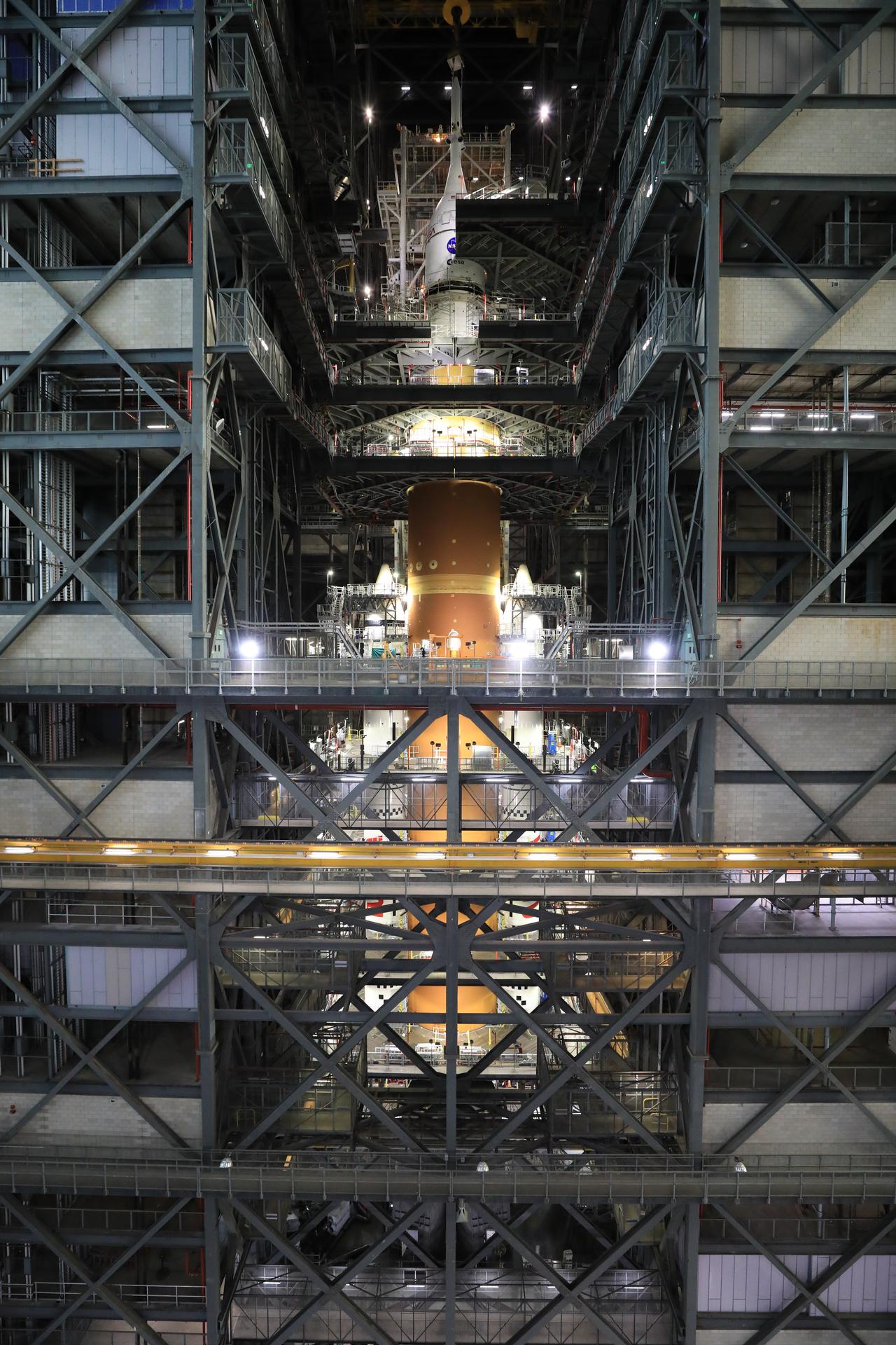
Technicians with NASA’s Exploration Ground Systems team use a crane to lift and secure NASA’s Orion spacecraft on top of the SLS (Space Launch System) rocket in High Bay 3 of the Vehicle Assembly Building at NASA’s Kennedy Space Center in Florida on Saturday, Oct. 18, 2025, for the agency’s Artemis II mission. Set to launch in 2026, the spacecraft will carry NASA astronauts Reid Wiseman, Victor Glover, Christina Koch, and CSA (Canadian Space Agency) astronaut Jeremy Hansen on a 10-day mission around the Moon and back. Once stacked, teams will begin conducting a series of verification tests ahead of rolling out to Launch Complex 39B for the wet dress rehearsal at NASA Kennedy.
NASA/Kim Shiflett
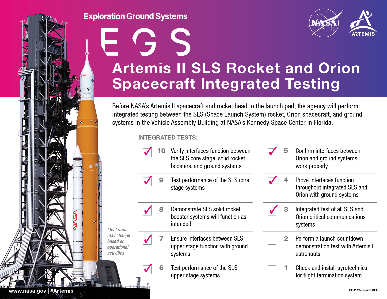
As 2026 nears, NASA continues moving forward to launching and flying Artemis II, the first crewed mission under the Artemis campaign, no later than April next year.
NASA’s Orion spacecraft, complete with its launch abort system escape tower, is now integrated with the SLS (Space Launch System) rocket in the Vehicle Assembly Building (VAB) at the agency’s Kennedy Space Center in Florida. Following Orion stacking, teams completed testing critical communications systems between SLS and Orion, and confirmed the interfaces function properly between the rocket, Orion, and the ground systems, including end-to-end testing with the Near Space Network and Deep Space Network, which aid in communications and navigation.
“NASA remains focused on getting ready to safely fly four astronauts around the Moon and back,” said acting NASA Administrator Sean Duffy. “Our mission will lay the groundwork for future missions to the lunar surface and to Mars.”
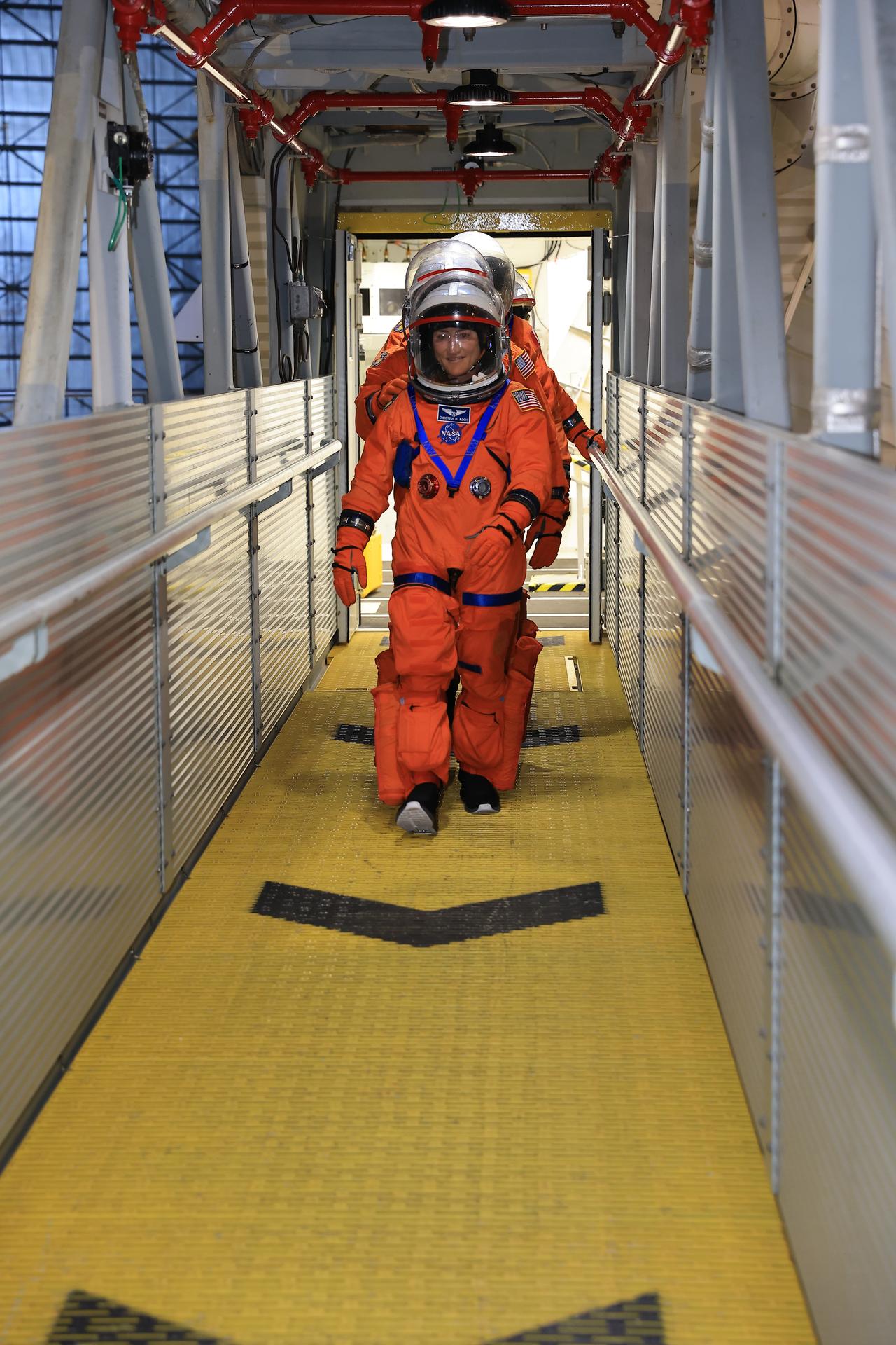
In the coming weeks, engineers and the Artemis II crew will conduct the first part of a Countdown Demonstration Test at Kennedy, a dress rehearsal for launch day. The crew will don their Orion crew survival system spacesuits and venture to their rocket before being secured inside Orion, which the crew recently named Integrity, simulating the final moments of the countdown. Because the rocket and spacecraft are not yet at the launch pad, the crew will board Orion inside the VAB. The test will serve as a final verification of the timeline for the crew and supporting teams on the ground. A second part of the test, preparing for an emergency at the launch pad, will occur after the rocket and spacecraft roll out to Launch Pad 39B.
NASA astronaut Christina Koch, Artemis II mission specialist, and the remaining Artemis II crew members walk on the crew access arm of the mobile launcher in the Vehicle Assembly Building at NASA’s Kennedy Space Center in Florida on Tuesday, Aug. 12, 2025.
NASA/Kim Shiflett
The Artemis II crew and ground personnel responsible for launching and flying the mission are preparing to conduct additional integrated simulations across teams and facilities to prepare for any scenario that could arise as the crew of four launches from Florida and flies their approximately 10-day mission.
NASA astronauts Reid Wiseman, Victor Glover, and Christina Koch, and CSA (Canadian Space Agency) astronaut Jeremy Hansen, have a busy schedule over the next several months reviewing procedures for all phases of flight until their preparations are second nature, practicing for different mission scenarios, and maintaining their familiarity with every element of their spacecraft.
Through Artemis, NASA will send astronauts to explore the Moon for scientific discovery, economic benefits, and build the foundation for the first crewed missions to Mars.
Preparations for Next Moonwalk Simulations Underway (and Underwater)
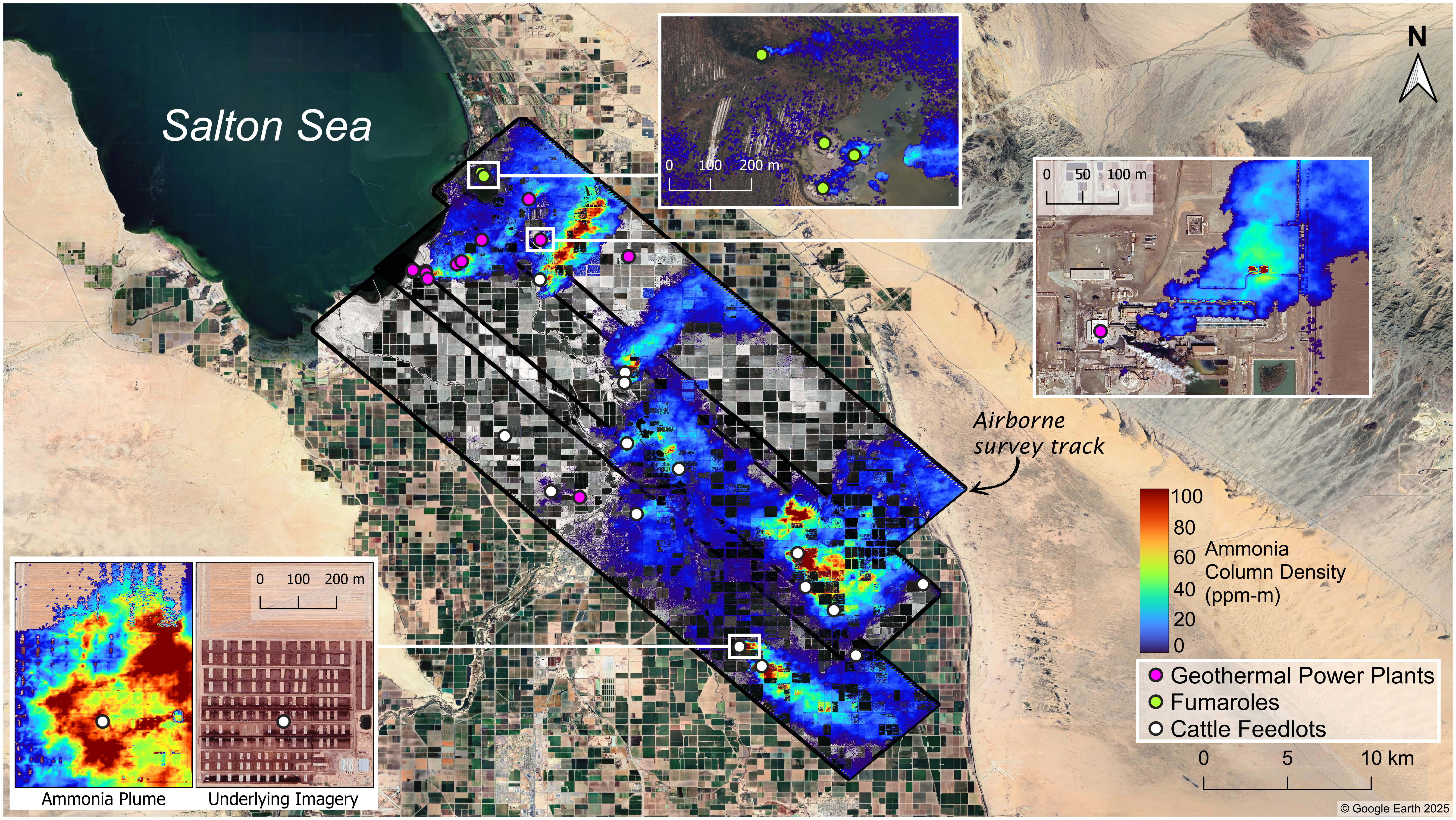
Researchers used data taken in March 2023 by an airborne imaging spectrometer to map ammonia emissions in the Imperial Valley. Produced by agricultural activities as well as geothermal processes, ammonia is a precursor to particulate matter, which can cause adverse health outcomes when inhaled.
NASA/JPL-Caltech
The pungent gas contributes to fine airborne particulate pollution, which endangers human health when inhaled and absorbed in the bloodstream.
A recent study led by scientists at NASA’s Jet Propulsion Laboratory in Southern California and the nonprofit Aerospace Corporation shows how high-resolution maps of ground-level ammonia plumes can be generated with airborne sensors, highlighting a way to better track the gas. A key chemical ingredient of fine particulate matter — tiny particles in the air known to be harmful when inhaled — ammonia can be released through agricultural activities such as livestock farming and geothermal power generation as well as natural geothermal processes. Because it’s not systematically monitored, many sources of the pungent gas go undetected.
Published in Atmospheric Chemistry and Physics in October, the study focuses on a series of 2023 research flights that covered the Imperial Valley to the southeast of the Salton Sea in inland Southern California, as well as the Eastern Coachella Valley to its northwest. Prior satellite-based research has identified the Imperial Valley as a prolific source of gaseous ammonia. In the study, scientists employed an airborne sensor capable of resolving ammonia plumes with enough detail to track their origins: Aerospace Corporation’s Mako instrument is an imaging spectrometer that observes long-wave infrared light emitted by areas of Earth’s surface and atmosphere 6 feet (2 meters) across.
Using the instrument, which can detect ammonia’s chemical signature by the infrared light it absorbs, the authors found elevated levels of the gas near several sources, including agricultural fields, livestock feedlots, geothermal plants, and geothermal vents. Measurements in parts of the Imperial Valley were 2½ to eight times higher than in Coachella Valley’s Mecca community, which had ammonia concentrations closer to background levels.
Though not toxic on its own in low concentrations, ammonia is a precursor to particulate matter, also known as aerosol or particle pollution. It reacts with other gases to form solid ammonium salt particles small enough to penetrate the bloodstream from the lungs. Particles under 2.5 micrometers in diameter — also known as PM2.5 — are associated with elevated rates of asthma, lung cancer, and cardiovascular disease, among other negative health outcomes.
“Historically, more attention has focused on primary sources of PM2.5, such as auto emissions. But with significant reductions in those emissions and increasingly stringent air quality standards, there is growing interest in understanding secondary sources that form particles in the air from precursor gases,” said Sina Hasheminassab, lead author of the paper and a research scientist at JPL. “As an important precursor to PM2.5, ammonia plays a key role, but its emissions are poorly characterized and undermonitored.”
Rising ammonia
Previous satellite-based studies have shown rising levels of atmospheric ammonia, both globally and in the continental United States. That research revealed broad trends, but with spatial resolution on the order of tens of miles, the measurements were only sufficient to identify variation over areas of hundreds of square miles or more.
The chemical behavior of ammonia also poses a particular monitoring challenge: Once emitted, it only stays in the atmosphere for hours before reacting with other compounds. In contrast, carbon dioxide can remain in the air for centuries.
Planes and satellites can provide an overview of sources and the geographic distribution of emissions at a given moment. Although satellites offer wider and more recurrent coverage, airborne instruments, being closer to the source, produce higher-resolution data and can focus on specific locations at designated times.
Those proved to be the right capabilities for the recent study. Researchers flew Mako over the Imperial and Eastern Coachella valleys on the mornings and afternoons of March 28 and Sept. 25, 2023, and took concurrent measurements on the ground with both a fixed monitoring station in Mecca operated by the South Coast Air Quality Management District (AQMD) and a mobile spectrometer developed at the University of California, Riverside.
“The goal was to show that this technique was capable of delivering data with the required accuracy that aerosol scientists and potentially even air quality regulatory bodies could use to improve the air quality in those regions,” said David Tratt, a senior scientist at Aerospace Corporation and coauthor of the paper. “We ended up with maps that identify multiple sources of ammonia, and we were able to track the plumes from their sources and observe them coalescing into larger clouds.”
Distinct plumes
During the flights, the team collected data over the southeastern coast of the Salton Sea, which straddles Riverside and Imperial counties. There, Mako revealed small plumes coming from geothermal fumaroles venting superheated water and steam that react with nitrogen-bearing compounds in the soil, releasing ammonia.
Farther to the southeast, the results showed several geothermal power plants emitting ammonia, primarily from their cooling towers, as part of their normal operations.
Farther southeast still, the researchers spotted ammonia emissions, a byproduct of animal waste, from cattle farms in the Imperial Valley. During the March 28 flight, a plume from the largest facility in the study area measured up to 1.7 miles (2.8 kilometers) wide and extended up to 4.8 miles (7.7 kilometers) downwind of the source.
‘Very large puzzle’
As part of the study, AQMD’s Mecca monitoring station recorded seasonal changes in ammonia concentrations. Given the few sources in the area, the researchers surmised that winds during certain months tend to blow the gas from Imperial Valley to the Coachella Valley.
The study underscores the benefits of detailed spatial information about ammonia emissions, and it partly informed the agency’s decision in July to expand its ammonia-monitoring network and extend the life of the Mecca station.
As a precursor to PM2.5, ammonia is “one piece of a very large puzzle” that, for Coachella Valley residents, includes vehicle emissions, desert dust, and agricultural activities, said Payam Pakbin, manager of the Advanced Monitoring Technologies Unit at AQMD and a paper coauthor.
“These communities want to know the contributions of these sources to the air quality they’re experiencing,” he added. “Findings like these help our agency better prioritize which sources require the most attention and ultimately guide our focus toward those that are the highest priority for achieving emission reductions in this community.”
Preparations for Next Moonwalk Simulations Underway (and Underwater)
The 2025 SARP East Atmospheric Chemistry Group poses in front of the Dynamic Aviation B-200 aircraft, parked in a hangar at NASA’s Wallops Flight Facility in Virginia. During the internship, students spend a week engaged in Earth science data collection and learning from instruments specialists while flying onboard both the B-200 and NASA’s P-3 aircraft.
Katherine Paredero, Georgia Institute of Technology
Atmospheric Chemistry Group Introduction
Faculty Advisor Stacey Hughes and Graduate MentorKatherine Paredero
Kaylena Pham
Spooky Swamps: How Methane Emission Rates and Their Spatial Variability Differ Between the Great Dismal Swamp and the Alligator River
Kaylena Pham, University of Southern California
Wetlands represent a dominant natural source of methane emissions to the atmosphere through methanogenesis, a process that produces methane in nutrient-depleted anoxic sediments, or as a result of decomposition. In coastal wetlands, particularly brackish regimes such as the Alligator River, severe storms and rising sea levels intensify saltwater intrusion inland. This leads to expansive vegetation death and the formation of ghost forests, large areas of dead standing vegetation. The widespread forest loss caused by salinization suggests elevated methane emissions in areas with vegetation stress through increased rates of decomposition from plant death. Previous research has not yet considered ghost forests when estimating methane emissions in wetlands, leading us to explore emission concentrations across two wetlands with similar vegetation compositions: the Great Dismal Swamp and Alligator River.
In this work, we utilized in-situ measurements collected aboard the Dynamic Aviation B-200 aircraft during the NASA Student Airborne Research Program (SARP) 2025 flight campaign. Methane and carbon monoxide measurements were determined using a PICARRO Gas Concentration Analyzer. This data was then linked with Normalized Difference Vegetation Index (NDVI) imagery from the Terra satellite’s Moderate Resolution Imaging Spectroradiometer (MODIS) instrument. With these two datasets, we studied how vegetation stress influences methane emissions. We observed greater vegetation stress in the Alligator River compared to the Great Dismal Swamp. Furthermore, the Alligator River has wider methane concentration variability occurring over areas with greater vegetation stress. In contrast, methane measurements over the Great Dismal Swamp have narrower distributions and less vegetation stress. This comparison of wetlands in differing vegetative states suggests a potential link between ecosystem stress and elevated methane emissions in wetland environments. Interestingly, despite these differences, the Great Dismal Swamp had a slightly higher mean methane concentration (2.11 ppm) compared to the Alligator River (1.96 ppm). Our results emphasize the importance of improving our understanding of what types of vegetation conditions lead to methane enhancements over wetland regimes.
Carson Turner
Calculating Methane Flux Over the Great Dismal Swamp Using the Mass Balance Technique
Carson Turner, University of North Dakota
Methane is one of the most potent greenhouse gases in the atmosphere, with a warming potential approximately 28 times larger than carbon monoxide. When examining the Global Methane Budget, wetlands are the largest natural source of methane accounting for 20-40% of global methane emissions. Wetland methane emissions have been shown to present the highest uncertainty due to both a lack of in-situ measurements to compare with models as well as a lack of understanding of how different conditions, like soil moisture and air temperature, affect methane emissions. This study looks specifically at The Great Dismal Swamp (GDS), located on the border of southeast Virginia and northeast North Carolina, to study emissions over the region using data collected on flights conducted as part of the Student Airborne Research Program (SARP) in the summer of 2025. A PICARRO Gas Concentration Analyzer was used to collect high frequency methane and carbon monoxide measurements. The two research flights followed similar flight paths around the GDS, on the 23rd and 24th of June. Methane flux was then calculated using the mass balance approach for each flight. Methane flux values were measured at 0.037 kg/s and 0.603 kg/s for the 23rd and 24th respectively. A similar study on wetlands in northern Sweden and Finland found an average methane flux value of 5.56 kg/s. A decreased methane flux value was observed on the flight day associated with higher temperatures, which is contrary to previous research on the relationship between methane emissions and temperature. Future work includes utilizing these flux measurements to improve our understanding of methane emissions from wetlands in models and further explore the relationship between methane emissions and soil moisture.
Alek Libby
Comparative Analysis of Urban Ozone Chemistry in Baltimore, Richmond, and Norfolk
Alek Libby , Florida State University
Urban ozone pollution remains a significant air quality concern in many U.S. cities. Ground-level ozone is not directly emitted but forms through photochemical reactions involving volatile organic compounds (VOCs) and nitrogen oxides (NOₓ) in the presence of sunlight—especially during the summer when incoming solar radiation is enhanced. The National Ambient Air Quality Standard set by the EPA for tropospheric ozone is 70 ppb, which is measured as an 8-hour average. Though exceedances of said standard have declined nationwide, understanding how emission composition varies across metropolitan areas remains critical. This study investigates the VOC makeup and ozone formation dynamics of three Mid-Atlantic urban environments: Baltimore, Richmond, and Norfolk. In-situ Whole Air Samples (WAS) were collected onboard the Aviation Dynamics B200 aircraft during the 2024 NASA Student Airborne Research Program (SARP) Campaign. Gas chromatography was used to quantify the VOC composition of each sample. Additional airborne data from CAFE and CANOE instruments provided measurements of formaldehyde (HCHO) and nitrogen dioxide (NO₂), respectively. This study looked at measurements collected below the boundary layer and within urban beltways to assess regional ozone production potential. Results showed that Baltimore exhibited significantly lower levels of key anthropogenic VOCs, particularly n-butane, i-pentane, and n-pentane. VOC/NOₓ ratios placed Richmond and Norfolk in NOₓ-limited regimes, while Baltimore fell within the transitional zone—supported by HCHO/NO₂ ratios averaging at 2.44 in Baltimore versus 5.14 and 5.09 in Norfolk and Richmond. Baltimore continues to experience notably more ozone exceedance days than Norfolk and Richmond, which is likely related to elevated NO₂ levels in the area. While reducing VOCs may help, these findings suggest that NOₓ reductions are likely more effective for mitigating ozone in the Baltimore area. Future work might replicate this analysis using the 2025 SARP dataset, which was collected on hot, stagnant days that are favorable for ozone production.
Hannah Suh
Characterization of Volatile Organic Compound (VOC) Sources in the Baltimore area
Hannah Suh, University of California, Santa Cruz
Volatile organic compounds (VOCs) play a key role in tropospheric photochemistry, as they react with nitrogen oxides (NOx) in sunlight to produce tropospheric ozone (O3). Both VOCs and tropospheric O3 can have negative impacts on air quality and human health. Understanding the sources of VOCs in urban areas such as Baltimore is essential for informing future air quality policies. In this study, in-situ VOC measurements collected onboard the Aviation Dynamics B200 aircraft during the NASA Student Airborne Research Program (SARP) were analyzed to characterize potential emission sources in the Baltimore area. VOC datasets from two flights from June 24th that flew over that location were investigated. This flight data was collected using aircraft instruments on the Aviation Dynamics B200, primarily the Whole Air Sampler (WAS). WAS canisters were later processed in lab using gas chromatography, which identified the different VOC mixing ratios in the air. VOCs ratios along with Positive Matrix Factorization (PMF), which reduces an inputted data matrix to separate out potential emission source contributions, were compared to each other to consider the most notable sources of VOCs in the Baltimore area. A total of six sources were looked at through PMF for this region. The top three sources seem to align with oil and natural gas, biogenic, and vehicular emissions. Chemical signature ratios indicate the presence of mixed plumes of both industrial and urban emissions, with many significant correlations with ethyne. These results point towards oil and natural gas industries, biogenic sources, and urban sources like vehicles as primary contributors to VOC signature ratios in the Baltimore area. A logical next step for this research would be to compare VOC signature ratios across multiple years to assess temporal trends.
Aashi Parikh
Characterizing VOC Emissions from Chemical Plant Plumes in Hopewell, VA
Aashi Parikh, Boston University
Hopewell, VA is home to a cluster of major chemical facilities, whose emissions have raised concerns in neighboring communities about air pollution and health disparities. While there is information about the historical pollution in Hopewell, few studies provide a comprehensive analysis of volatile organic compounds (VOCs). This study investigates the distribution of VOCs in Hopewell’s industrial corridor and
In-situ whole air samples (WAS) were collected aboard the Aviation Dynamics B200 during the NASA Student Airborne Research Program in June 2024. In this study, samples collected at Hopewell were compared to the rest of the flight. The values were separated by chemical families, and enhancements were identified. The analysis showed that Hopewell had significant levels of aromatics, with 60 ppt of benzene, 119 ppt of toluene, and 47 ppt of styrene, which are VOCs linked to respiratory illness, neurological disorders, reproductive issues, and cancer. Aromatics observed over Hopewell were approximately 5x higher than that of the remaining flight path. According to the EPA, these carcinogenic compounds have no safe threshold for chronic exposure. As such, long-term exposure to these compounds can pose health risks. These findings reinforce existing health outcome disparities in the region, such as elevated cancer rates, and raise concerns about the exposure of nearby communities. Underserved communities are disproportionately being impacted by such health risks in Hopewell. Future research will evaluate VOC concentrations over Hopewell in 2025 and compare them to the 2024 baseline established in this study, providing insight into whether emissions reductions have occurred and if regulatory or community-driven interventions are showing impact.
Preparations for Next Moonwalk Simulations Underway (and Underwater)
The 2025 SARP East Oceans Group poses in front of the Dynamic Aviation B-200 aircraft, parked in a hangar at NASA’s Wallops Flight Facility in Virginia. During the internship, students spend a week engaged in Earth science data collection and learning from instruments specialists while flying onboard both the B-200 and NASA’s P-3 aircraft.
Faculty Advisor Tom Bell and Graduate Mentor Sarah Lang
Isabella Showman
Detecting Coastal Sea Ice Extent and Freshet Event Timing in Prudhoe Bay, Alaska Using Sentinel-1 C-SAR
Isabella Showman, University of Washington
The detachment of coastal sea ice due to increasing upstream snowmelt causes dramatic seasonal changes in the Arctic Ocean. Termed a freshet, these freshwater pulses influence the timing of sea ice degradation, but the effects are difficult to quantify because of frequent cloud cover and limited ground observations. Sentinel-1 C-SAR (Synthetic Aperture Radar) collects high-spatiotemporal data using microwave radiation backscatter allowing it to see through clouds, making it a valuable tool to identify freshet timing in the Arctic.
We used SAR imagery to classify seasonal sea ice extent for a 45 km transect north of Prudhoe Bay, Alaska. The backscatter signature of SAR is influenced by roughness, and since ocean water is smoother than ice, the backscatter differences allow for the estimation of proportional sea ice cover along the transect. We validated the accuracy of our SAR classifications using shortwave infrared from cloud-free Sentinel-2 images, and found strong agreement between the methods. We then calculated the average annual percent ice cover from 2017 to 2024, serving as a seasonal baseline to compare against individual years. We found mean sea ice decline throughout the spring and summer months and associated freshet event timing to begin in the middle of June. The rate of decline in sea ice cover along the transect has higher variability in the weeks following the onset of sea ice melt.
The use of SAR to track localized seasonal ice melt and identify the timing of spring freshet events allows for a more complete seasonal time series than optical imagery alone. Variability in Arctic freshet timing influences how and when sea ice degradation begins, having potential implications for organisms reliant on sea ice extent and larger-scale surface albedo. This study also lays the groundwork for future investigations to better understand across- watershed variability and environmental factors like river discharge and surface temperature on freshet timing.
Sarah Gryskewicz
Investigating the Impacts of the January 2025 California Wildfires on Phytoplankton Blooms in the Pacific Ocean
Sarah Gryskewicz, State University of New York at Oswego
Wildfires are increasing in frequency and intensity across North America as a result of climate change. The release of particulates by these events result in short-range and long-range implications on human and ecophysiological health. Marine ecosystems may also be impacted due to the deposition of these chemical constituents, particularly ash, which can alter nutrient cycling in the water by fertilization and reduce light availability for phytoplankton. Phytoplankton are microscopic organisms that live in marine waters and are responsible for half of the photosynthetic activity on Earth. An area of complex interdisciplinary research concerns the interactions between wildfires and the marine ecosystem. There is a large scientific need to understand biogeochemical cycling between wildfire emissions and phytoplankton blooms.
This study investigates the January 2025 California wildfire impacts on phytoplankton blooms offshore the southern California coast in nutrient limited waters. The Visible Infrared Imaging Radiometer Suite (VIIRS) onboard the Suomi National Polar-orbiting Partnership (SNPP) satellite is used to assess interannual and seasonal variabilities while the Plankton, Aerosol, Cloud, ocean Ecosystem (PACE) satellite was utilized for the additional ocean-based analyses. Variables considered include chlorophyll-a (chl-a) as a proxy for phytoplankton biomass, particulate organic carbon (POC) to assess phytoplankton physiology, and diffuse attenuation at 490 nm (Kd490) to assess light availability. From this analysis, it was found that there was no evident fertilization of a phytoplankton bloom given that chl-a eight-day composites did not deviate significantly from 2012-2025 average geometric mean concentrations. Analyses of the chl-a:POC and chl-a:Kd490 ratios suggest a potential physiological or phytoplankton community shift, but future work using in-situ data is necessary to connect wildfires impacts on phytoplankton communities offshore Southern California. Additionally, the research sets the stage for future work using PACE to investigate impacts on phytoplankton community groups. Future research also involves the expansion of sample wildfire cases and consideration of forested versus urban emission impacts.
Philip Espinal
How Well Can Machine Learning Forecast Kelp Biomass Along the Central California Coast?
Philip Espinal, Texas A&M University
Giant Kelp is an integral part of the coastal ecosystem off the Central California Coast because it provides food and shelter for several marine organisms, and supports a multi-million dollar commercial fishing industry. In recent decades, Giant Kelp forests have been in decline due to warming ocean temperatures and overgrazing by marine organisms such as sea urchins. Conservation efforts like outplanting, transplanting, and sea urchin removal are occurring in an effort to restore Giant Kelp populations along the California Coast. Knowing when the environment will be favorable for kelp growth is important to focus conservation resources and effort most efficiently. Observations from the Landsat series of satellites allow for the estimation of kelp biomass density going back to 1984. Two machine learning algorithms, random forests and a simple neural network, were trained on the Landsat observations, coastal wave model output, climate indices, and reanalysis products from 1984 to 2015. Models were evaluated on the mean absolute error (MAE) for predictions from 2016 to 2021, as well the MAE and mean absolute percent error (MAPE) of just the third quarters, when maximum biomass density is typically achieved. The random forest models showed little skill even at the minimum forecast horizon of one quarter, performing similar to a prediction made by a 5-year rolling seasonal average. The neural networks performed significantly better than the random forests and seasonal averages when forecasting one quarter into the future, and performed marginally better at two and four quarters into the future. The neural network trained to forecast one quarter ahead had a third quarter MAPE of 13.4% while the 5-year seasonal average had a MAPE of 42.8%. Models performed poorly in the area surrounding Monterey, greatly overestimating the amount of kelp biomass. This overprediction may be due to the severe reduction in kelp biomass since 2015 due to sea urchin overgrazing. While the predictions did not match the actual outcome, the environment may have in fact still been productive for kelp if not for the presence of sea urchins. Overall, these models can serve as a proof of concept that machine learning models, especially neural networks, can use current environmental conditions to forecast kelp biomass one to two quarters into the future, providing useful operational guidance for conservationists.
Carolyn Chen
Sea Surface Temperature as an Indicator of Benthic Symbiont Loss in the Florida Keys: A Comparative Analysis of ECOSTRESS and MODIS
Carolyn Chen, University of Florida
Coral bleaching events, which pose significant threats to marine biodiversity and reef structure, have increased in frequency and severity over recent decades. Accurate monitoring of sea surface temperature is vital for understanding the drivers of zooxanthellae loss in these foundational habitats. Traditional methods of satellite temperature data collection have relatively coarse spatial resolution (1 km). This can obscure finer-scale thermal variability, especially in nearshore and coastal reef environments where localized temperature anomalies may lead to significant biological impacts. Here, we use ECOSTRESS at a fine spatial resolution (70 m) to investigate the relationships between sea surface temperature and bleaching in the Florida Keys. Thermal imagery from July 24, 2023 was spatially overlaid with in situ coral bleaching survey data to investigate potential thermal stress–bleaching relationships. We then quantified this relationship through correlation analyses at varying spatial thresholds, examining the strength and direction of associations between sea surface temperature and corresponding levels of coral bleaching intensity across survey sites. Parallel analyses were conducted using MODIS for comparative assessment. We were able to determine that ECOSTRESS sea surface temperature had a weak association with bleaching intensity (r² = 0.348, p<0.001). Greater thresholds yielded lower correlation. Comparatively, MODIS showed low correlation at all spatial thresholds. These findings demonstrate the potential of ECOSTRESS for quantifying thermal relationships and lays the groundwork for future work across temporal scales.
Joshua Chapin
Impacts of Atmospheric Rivers on Phytoplankton in the Central California Current System
Joshua Chapin, The University of Alabama in Huntsville
Atmospheric rivers (ARs) are powerful meteorological events that deliver large volumes of freshwater to coastal systems, potentially reshaping oceanographic and ecological conditions. This study investigates the impact of AR-induced freshwater outflow—specifically from the Russian River (RR) and other freshwater sources–on phytoplankton communities in the central California Current System on April 11, 2023. Using Sentinel-3 ocean color reflectance bands within the visual spectrum (e.g., bands 2 through 11), we applied k-means clustering to classify waters with distinct bio-optical properties. To validate and interpret these water types, we integrated data from NASA’s Sub-Mesoscale Ocean Dynamics Experiment (S-MODE) field campaign, including flow-through measurements of temperature, salinity, chlorophyll-a, and particulate organic carbon (POC), along with bottle sample data on nutrients and high-performance liquid chromatography (HPLC) pigments (e.g., fucoxanthin, peridinin, nitrate). These in situ observations revealed physical and biological signatures across the clustered water masses. One cluster is characterized by cold temperatures, low salinity, low chlorophyll-a concentrations. The cluster is also characterized by reduced fucoxanthin (denoting reduced diatom concentrations) and low nitrate. These T/S and bio-optical characteristics suggest an association with terrestrial outflow, potentially linked to AR-driven discharge from the Russian River and adjacent watersheds. However, within the same T/S space, elevated chlorophyll-a concentrations are observed, indicating that some RR water is associated with elevated productivity. . T/S diagrams also indicated that elevated chl-a was associated with mixing of the RR with surrounding waters. In contrast, other clusters were characterized by warmer temperatures, higher salinity, elevated chlorophyll-a concentrations, higher nitrate levels, and higher accessory pigment concentrations such as alloxanthin and prasinoxanthin (associated with this cluster). Overall, these contrasting signatures among clustered water masses illustrate the ecological gradients shaped by AR-driven freshwater delivery. This integrated approach highlights the ecological consequences of terrestrial runoff following AR events and demonstrates the utility of combining satellite-based classifications with high-resolution in situ measurements to monitor phytoplankton variability in dynamic coastal environments.
Eli Mally
Predicting Phytoplankton Pigment Groups in Coastal Southern California with PACE
Eli Mally, University of California, Irvine
Phytoplankton produce half of the world’s oxygen, influence nutrient cycling, and form the basis of the ocean’s food chain. Predicting phytoplankton pigment groups from hyperspectral satellite data, especially in coastal areas where accurate retrievals are challenging, is crucial to gaining a better understanding of ocean ecosystems. Phytoplankton community models from hyperspectral data (such as the MOANA model) have recently become available for the Atlantic, but are not yet available for the Pacific Ocean. To address this observational gap, we created regional models of phytoplankton pigment groups in coastal southern California. We used Level 2 Ocean Color Instrument reflectance data in mid-September 2024 from the NASA PACE satellite. We matched the reflectance data with in situ high performance liquid chromatography (HPLC) data from PACE validation cruises (PACE-PAX) in the Santa Barbara Channel and near Long Beach, with a focus on total chlorophyll, chlorophyll-a, -b, and -c, and five pigments associated with different phytoplankton groups characterized in Kramer et al. 2022 (diatoms, dinoflagellates, haptophytes, green algae, and cyanobacteria). We then performed a principal component regression on the satellite data to find models for each pigment. This project resulted in significant models and R2 values for total chlorophyll (0.911), chlorophyll-a (0.868), -b (0.650), and -c (0.861), 19′-hexanoyloxyfucoxanthin (0.517), peridinin (0.327), zeaxanthin (0.381), fucoxanthin (0.678), and monovinyl chlorophyll-b (0.650). Furthermore, these results help validate PACE satellite measurements, which provide much finer spectral detail on phytoplankton community groups than multispectral data. Further cruises in this area would increase the scope and amount of HPLC samples, and therefore the accuracy and scope of our phytoplankton pigment models.
This website uses cookies to improve your experience. We'll assume you're ok with this, but you can opt-out if you wish.AcceptRead More
Privacy & Cookies Policy
Privacy Overview
This website uses cookies to improve your experience while you navigate through the website. Out of these, the cookies that are categorized as necessary are stored on your browser as they are essential for the working of basic functionalities of the website. We also use third-party cookies that help us analyze and understand how you use this website. These cookies will be stored in your browser only with your consent. You also have the option to opt-out of these cookies. But opting out of some of these cookies may affect your browsing experience.
Necessary cookies are absolutely essential for the website to function properly. This category only includes cookies that ensures basic functionalities and security features of the website. These cookies do not store any personal information.
Any cookies that may not be particularly necessary for the website to function and is used specifically to collect user personal data via analytics, ads, other embedded contents are termed as non-necessary cookies. It is mandatory to procure user consent prior to running these cookies on your website.