Preparations for Next Moonwalk Simulations Underway (and Underwater)
How are we made of star stuff?
Well, the important thing to understand about this question is that it’s not an analogy, it’s literally true.
The elements in our bodies, the elements that make up our bones, the trees we see outside, the other planets in the solar system, other stars in the galaxy. These were all part of stars that existed well before our Sun and Earth and solar system were even formed.
The universe existed for billions of years before we did. And all of these elements that you see on the periodic table, you see carbon and oxygen and silicon and iron, the common elements throughout the universe, were all put there by previous generations of stars that either blew off winds like the Sun blows off a solar wind, or exploded in supernova explosions and thrust their elements throughout the universe.
These are the same things that we can trace with modern telescopes, like the Hubble Telescope and the James Webb Space Telescope, the Chandra X-ray Observatory. These are all elements that we can map out in the universe with these observatories and trace back to the same things that form us and the elemental abundances that we see in stars now are the same things that we see in the Earth’s crust, we see in asteroids. And so we know that these are the same elements that were once part of these stars.
So the question of, “How are we made of star stuff?”, in the words of Carl Sagan, “The cosmos is within us. We are made of star stuff. We are a way for the universe to know itself.”
NASA 3D Wind Measuring Laser Aims to Improve Forecasts from Air, Space
3D wind measurements from NASA’s Aerosol Wind Profiler instrument flying on board a specially mounted aircraft along the East Coast of the U.S. and across the Great Lakes region on Oct. 15, 2024.
Credits: NASA/Scientific Visualization Studio
Since last fall, NASA scientists have flown an advanced 3D Doppler wind lidar instrument across the United States to collect nearly 100 hours of data — including a flight through a hurricane. The goal? To demonstrate the unique capability of the Aerosol Wind Profiler (AWP) instrument to gather extremely precise measurements of wind direction, wind speed, and aerosol concentration – all crucial elements for accurate weather forecasting.
Weather phenomena like severe thunderstorms and hurricanes develop rapidly, so improving predictions requires more accurate wind observations.
“There is a lack of global wind measurements above Earth’s surface,” explained Kris Bedka, the AWP principal investigator at NASA’s Langley Research Center in Hampton, Virginia. “Winds are measured by commercial aircraft as they fly to their destinations and by weather balloons launched up to twice per day from just 1,300 sites across the globe. From space, winds are estimated by tracking cloud and water vapor movement from satellite images.”
However, in areas without clouds or where water vapor patterns cannot be easily tracked, there are typically no reliable wind measurements. The AWP instrument seeks to fill these gaps with detailed 3D wind profiles.
The AWP instrument (foreground) and HALO instrument (background) was integrated onto the floorboard of NASA’s G-III aircraft. Kris Bedka, project principal investigator, sitting in the rear of the plane, monitored the data during a flight on Sept. 26, 2024.
NASA/Maurice Cross
Mounted to an aircraft with viewing ports underneath it, AWP emits 200 laser energy pulses per second that scatter and reflect off aerosol particles — such as pollution, dust, smoke, sea salt, and clouds — in the air. Aerosol and cloud particle movement causes the laser pulse wavelength to change, a concept known as the Doppler effect.
The AWP instrument sends these pulses in two directions, oriented 90 degrees apart from each other. Combined, they create a 3D profile of wind vectors, representing both wind speed and direction.
We are measuring winds at different altitudes in the atmosphere simultaneously with extremely high detail and accuracy.
Kris bedka
NASA Research Physical Scientist
“The Aerosol Wind Profiler is able to measure wind speed and direction, but not just at one given point,” Bedka said. “Instead, we are measuring winds at different altitudes in the atmosphere simultaneously with extremely high detail and accuracy.”
Vectors help researchers and meteorologists understand the weather, so AWP’s measurements could significantly advance weather modeling and forecasting. For this reason, the instrument was chosen to be part of the National Oceanic and Atmospheric Administration’s (NOAA) Joint Venture Program, which seeks data from new technologies that can fill gaps in current weather forecasting systems. NASA’s Weather Program also saw mutual benefit in NOAA’s investments and provided additional support to increase the return on investment for both agencies.
On board NASA’s Gulfstream III (G-III) aircraft, AWP was paired with the agency’s High-Altitude Lidar Observatory (HALO) that measures water vapor, aerosols, and cloud properties through a combined differential absorption and high spectral resolution lidar.
Working together for the first time, AWP measured winds, HALO collected water vapor and aerosol data, and NOAA dropsondes (small instruments dropped from a tube in the bottom of the aircraft) gathered temperature, water vapor, and wind data.
The AWP and HALO instrument teams observing incoming data on board NASA’s G-III aircraft over Tennessee while heading south to observe Hurricane Helene. Sept. 26, 2024.
NASA/Maurice Cross
“With our instrument package on board small, affordable-to-operate aircraft, we have a very powerful capability,” said Bedka. “The combination of AWP and HALO is NASA’s next-generation airborne weather remote sensing package, which we hope to also fly aboard satellites to benefit everyone across the globe.”
The combination of AWP and HALO is NASA’s next-generation airborne weather remote sensing package.
kris bedka
NASA Research Physical Scientist
The animation below, based on AWP data, shows the complexity and structure of aerosol layers present in the atmosphere. Current prediction models do not accurately simulate how aerosols are organized throughout the breadth of the atmosphere, said Bedka.
This visualization shows AWP 3D measurements gathered on Oct. 15, 2024, as NASA’s G-III aircraft flew along the East Coast of the U.S. and across the Great Lakes region. Laser light that returns to AWP as backscatter from aerosol particles and clouds allows for measurement of wind direction, speed, and aerosol concentration as seen in the separation of data layers.
NASA/Scientific Visualization Studio
“When we took off on this particular day, I thought that we would be finding a clear atmosphere with little to no aerosol return because we were flying into what was the first real blast of cool Canadian air of the fall,” described Bedka. “What we found was quite the opposite: an aerosol-rich environment which provided excellent signal to accurately measure winds.”
During the Joint Venture flights, Hurricane Helene was making landfall in Florida. The AWP crew of two pilots and five science team members quickly created a flight plan to gather wind measurements along the outer bands of the severe storm.
This video shows monitors tracking the AWP science team’s location in the western outer bands of Hurricane Helene off the coast of Florida with views outside of the aircraft looking at turbulent storm clouds on Sept. 26, 2024.
NASA/Kris Bedka
“A 3D wind profile can significantly improve weather forecasts, particularly for storms and hurricanes,” said Harshesh Patel, NOAA’s acting Joint Venture Program manager. “NASA Langley specializes in the development of coherent Doppler wind lidar technology and this AWP concept has potential to provide better performance for NOAA’s needs.”
The flight plan of NASA’s G-III aircraft – outfitted with the Aerosol Wind Profiler – as it gathered data across the Southeastern U.S. and flew through portions of Hurricane Helene on Sept. 26, 2024. The flight plan is overlaid atop a NOAA Geostationary Operational Environmental Satellite-16 (GOES) satellite image from that day.
NASA/John Cooney
The flights of the AWP lidar are serving as a proving ground for possible integration into a future satellite mission.
“The need to improve global 3D wind models requires a space-based platform,” added Patel. “Instruments like AWP have specific space-based applications that potentially align with NOAA’s mission to provide critical data for improving weather forecasting.”
A view of the outer bands of Hurricane Helene off the coast of Florida during NASA’s science flights demonstrating the Aerosol Wind Profiler instrument on Sept. 26, 2024.
NASA/Maurice Cross
After the NOAA flights, AWP and HALO were sent to central California for theWestcoast & Heartland Hyperspectral Microwave Sensor Intensive Experiment and the Active Passive profiling Experiment, which was supported by NASA’s Planetary Boundary Layer Decadal Survey Incubation Program and NASA Weather Programs. These missions studied atmospheric processes within the planetary boundary layer, the lowest part of the atmosphere, that drives the weather conditions we experience on the ground.
To learn more about lidar instruments at NASA visit:
X-ray: NASA/SAO/CXC; Optical: John Stone (Astrobin); Image Processing: NASA/SAO/CXC/L. Frattre, N. Wolk
The Cygnus Loop, also known as the Veil Nebula, is a supernova remnant – the remains of the explosive death of a massive star. Studying images like these leads to discovery, but NASA’s Chandra X-ray Observatory provides another way to experience this data: three-dimensional (3D) models that allow people to explore – and print – examples of stars in the early and end stages of their lives.
The 3D model of the Cygnus Loop is the result of a simulation describing the interaction of a blast wave from the explosion with an isolated cloud of the interstellar medium (that is, dust and gas in between the stars). Chandra sees the blast wave and other material that has been heated to millions of degrees. These 3D models are based on state-of-the-art theoretical models, computational algorithms, and observations from space-based telescopes like Chandra that give us accurate pictures of these cosmic objects and how they evolve over time.
Preparations for Next Moonwalk Simulations Underway (and Underwater)
On April 16, 2025, the Earth Science Division at NASA’s Ames Research Center in Silicon Valley held an Earth Science Showcase to share its work with the center and their families. As part of this event, kids were invited to share something they like about the Earth. These are their masterpieces.
Sora U. Age 9. “Wildlife”
Sora U. Age 9. “Wildlife”
Wesley P. Age 2.5. “Pale Blue”
Wesley P. Age 2.5. “Pale Blue”
Kira U. Age 5. “Hawaii”
Kira U. Age 5. “Hawaii”
Anonymous. “eARTh”
Anonymous. “eARTh”
Brooks P. Age 8mo. “Squiggles”
Brooks P. Age 8mo. “Squiggles”
About the Author
Milan Loiacono
Science Communication Specialist
Milan Loiacono is a science communication specialist for the Earth Science Division at NASA Ames Research Center.
Preparations for Next Moonwalk Simulations Underway (and Underwater)
Gateway’s HALO module at Northrop Grumman’s facility in Gilbert, Arizona, on April 4, 2025, shortly after its arrival from Thales Alenia Space in Turin, Italy.
NASA/Josh Valcarcel
NASA continues to mark progress on plans to work with commercial and international partners as part of the Gateway program. The primary structure of HALO (Habitation and Logistics Outpost) arrived at Northrop Grumman’s facility in Gilbert, Arizona, where it will undergo final outfitting and verification testing.
HALO will provide Artemis astronauts with space to live, work, and conduct scientific research. The habitation module will be equipped with essential systems including command and control, data handling, energy storage, power distribution, and thermal regulation.
Following HALO’s arrival on April 1 from Thales Alenia Space in Turin, Italy, where it was assembled, NASA and Northrop Grumman hosted an April 24 event to acknowledge the milestone, and the module’s significance to lunar exploration. The event opened with remarks by representatives from Northrop Grumman and NASA, including NASA’s Acting Associate Administrator for Exploration Systems Development Lori Glaze, Gateway Program Manager Jon Olansen, and NASA astronaut Randy Bresnik. Event attendees, including Senior Advisor to the NASA Administrator Todd Ericson, elected officials, and local industry and academic leaders, viewed HALO and virtual reality demonstrations during a tour of the facilities.
Dr. Lori Glaze, acting associate administrator for NASA’s Exploration Systems Development Mission Directorate, and Dr. Jon B. Olansen, Gateway Program manager, on stage during an April 24, 2025, event at Northrop Grumman’s facility in Gilbert, Arizona, commemorating HALO’s arrival in the United States.
Northrop Grumman
While the module is in Arizona, HALO engineers and technicians will install propellant lines for fluid transfer and electrical lines for power and data transfer. Radiators will be attached for the thermal control system, as well as racks to house life support hardware, power equipment, flight computers, and avionics systems. Several mechanisms will be mounted to enable docking of the Orion spacecraft, lunar landers, and visiting spacecraft.
Launching on top of HALO is the ESA (European Space Agency)-provided Lunar Link system which will enable communication between crewed and robotic systems on the Moon and to mission control on Earth. Once these systems are installed, the components will be tested as an integrated spacecraft and subjected to thermal vacuum, acoustics, vibration, and shock testing to ensure the spacecraft is ready to perform in the harsh conditions of deep space.
In tandem with HALO’s outfitting at Northrop Grumman, the Power and Propulsion Element – a powerful solar electric propulsion system – is being assembled at Maxar Space Systems in Palo Alto, California. Solar electric propulsion uses energy collected from solar panels converted to electricity to create xenon ions, then accelerates them to more than 50,000 miles per hour to create thrust that propels the spacecraft.
The element’s central cylinder, which resembles a large barrel, is being attached to the propulsion tanks, and avionics shelves are being installed. The first of three 12-kilowatt thrusters has been delivered to NASA’s Glenn Research Center in Cleveland for acceptance testing before delivery to Maxar and integration with the Power and Propulsion Element later this year.
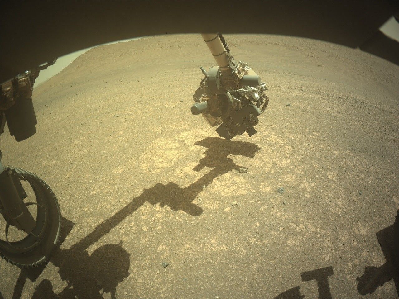
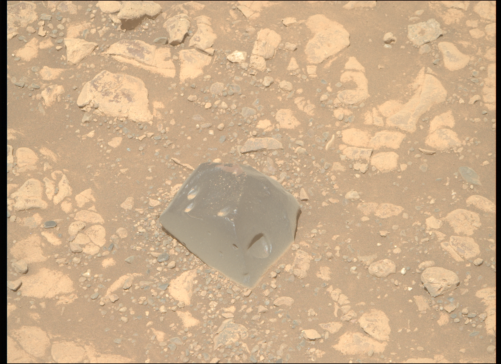
The Perseverance rover acquired this image of the “Hare Bay” abrasion patch using its SHERLOC WATSON camera (Scanning Habitable Environments with Raman and Luminescence for Organics and Chemicals, and the Wide Angle Topographic Sensor for Operations and eNgineering), located on the turret at the end of the rover’s robotic arm. This image was acquired on April 18, 2025 (Sol 1479, or Martian day 1,479 of the Mars 2020 mission) at the local mean solar time of 12:53:57.
NASA/JPL-Caltech
Written by Eleanor Moreland, Ph.D. Student Collaborator at Rice University
Perseverance has been busy exploring lower “Witch Hazel Hill,” an outcrop exposed on the edge of the Jezero crater rim. The outcrop is composed of alternating light and dark layers, and naturally, the team has been trying to understand the makeup of and relationships between the light and dark layers. A few weeks ago, we sampled one of the light-toned layers, which we discovered was made up of very small clasts, or fragments of rocks or minerals, at “Main River.” Since then, we have learned that the dark layers tend to be composed of larger clasts compared to the light layers, and we’ve been searching for a place to sample this coarser-grained rock type. Sometimes, these coarser-grained rocks also contain spherules, which are of great interest to the science team because they provide clues about the process that formed these layered rocks.
Perseverance first looked at a dark layer at “Puncheon Rock” with an abrasion. We then examined a dark layer at “Wreck Apple,” near “Sally’s Cove,” but we could not identify a suitable surface to abrade. So, while team members searched for other locations to study the coarse-grained units and spherules, Perseverance drove south to “Port Anson.”
Perseverance acquired this image of the “Strong Island” workspace near Port Anson using its onboard Front Left Hazard Avoidance Camera A (https://science.nasa.gov/mission/mars-2020-perseverance/rover-components/#eyes). This image was acquired on April 12, 2025 (Sol 1473, or Martian day 1,473 of the Mars 2020 mission) at the local mean solar time of 12:50:32.
NASA/JPL-Caltech
Port Anson was intriguing because, from orbit, it showed a clear contact between the light layers of Witch Hazel Hill and a distinct unit below it. And, although the rocks below the Port Anson contact do show interesting compositional differences with those of Witch Hazel Hill, they weren’t the coarse-grained rocks we were looking for. We still performed an abrasion there, at Strong Island, before driving back up north for another attempt at investigating the coarser-grained rocks.
We aimed for “Pine Pond,” which neighbors “Dennis Pond,” to abrade at “Hare Bay.” With the data just coming down over the weekend, the team will be hard at work to figure out if we captured the coarse grains and spherules, and if it is representative of rocks we have seen before or not. The image below is a close-up of this most recent abrasion patch at Hare Bay — what do you think? Stay tuned to find out!
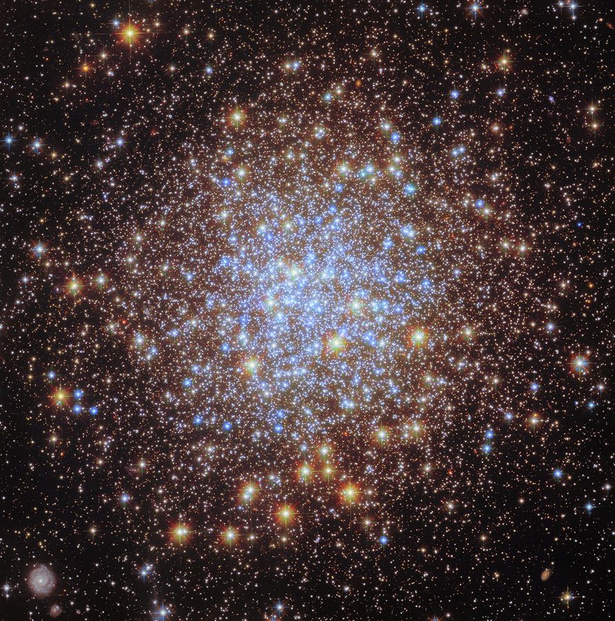
This NASA/ESA Hubble Space Telescope image features the globular cluster Messier 72 (M72).
ESA/Hubble & NASA, A. Sarajedini, G. Piotto, M. Libralato
As part of ESA/Hubble’s 35th anniversary celebrations, the European Space Agency (ESA) shared new images that revisited stunning, previously released Hubble targets with the addition of the latest Hubble data and new processing techniques.
M72 is a collection of stars, formally known as a globular cluster, located in the constellation Aquarius roughly 50,000 light-years from Earth. The intense gravitational attraction between the closely packed stars gives globular clusters their regular, spherical shape. There are roughly 150 known globular clusters associated with the Milky Way galaxy.
The striking variety in the color of the stars in this image of M72, particularly compared to the original image, results from the addition of ultraviolet observations to the previous visible-light data. The colors indicate groups of different types of stars. Here, blue stars are those that were originally more massive and have reached hotter temperatures after burning through much of their hydrogen fuel; the bright red objects are lower-mass stars that have become red giants. Studying these different groups help astronomers understand how globular clusters, and the galaxies they were born in, initially formed.
Pierre Méchain, a French astronomer and colleague of Charles Messier, discovered M72 in 1780. It was the first of five star clusters that Méchain would discover while assisting Messier. They recorded the cluster as the 72nd entry in Messier’s famous collection of astronomical objects. It is also one of the most remote clusters in the catalog.
Students take a tour of the Glenn International Space Station Payload Operations Center at NASA’s Glenn Research Center in Cleveland, where researchers operate International Space Station experiments, during 4-H Day on June 14, 2024.
Credit: NASA/Jef Janis
Ohio middle school students will step into the shoes of real-world NASA professionals for a day of career exploration and hands-on activities at NASA’s Glenn Research Center in Cleveland. Nearly 200 students are slated to participate in TECH Day at NASA Glenn on May 1, from 10 a.m. to 1 p.m. Media are invited to attend.
TECH Day is designed to inspire and inform the next generation of innovators by introducing them to clear and attainable career pathways into the aerospace industry. Students will tour NASA Glenn facilities, participate in an interactive engineering challenge, and engage with professionals to learn about the wide range of careers in STEM fields.
Student tours will include the following Glenn facilities:
Graphics and Visualization Lab, where researchers create engaging projects using virtual and augmented reality
Glenn International Space Station Payload Operations Center, where researchers remotely operate experiments aboard the International Space Station
Simulated Lunar Operations Laboratory, a unique indoor space designed to mimic the surface of the Moon and Mars
10×10 Supersonic Wind Tunnel, NASA Glenn’s largest and fastest wind tunnel facility
Creating Clear Pathways
Developing early and accessible entry points into STEM careers is essential to meeting the growing demand for a skilled technical workforce. NASA STEM engagement events help students visualize their future and better understand the technical experience needed for a career in the aerospace sector. Opportunities like this equip students with the skills to further technological advancement and become the STEM professionals of tomorrow.
Media interested in attending should contact Jacqueline Minerd at jacqueline.minerd@nasa.gov no later than 5 p.m. Wednesday, April 30. Interviews with experts will take place from 9 to 10 a.m.
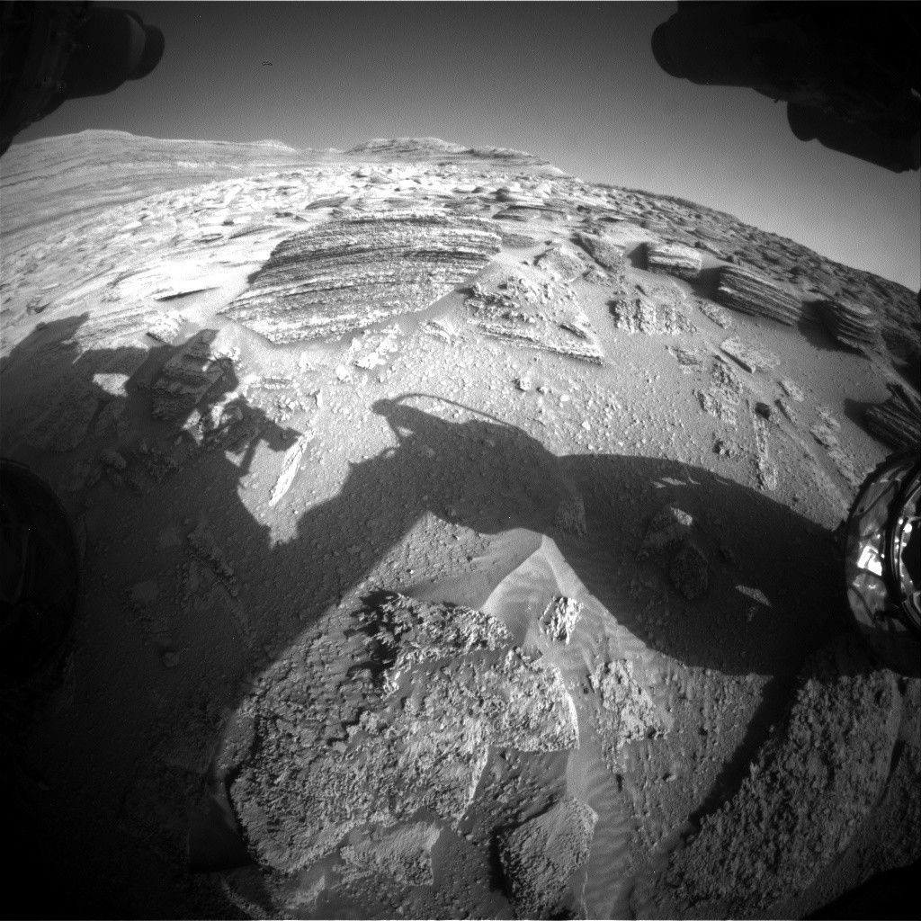
NASA’s Mars rover Curiosity acquired this image of its target area — including the layered rocks “Hale Telescope” and “Fan Palm” — using its Front Hazard Avoidance Camera on April 22, 2025 (Sol 4518, or Martian day 4,518 of the Mars Science Laboratory mission) at 11:03:37 UTC.
NASA/JPL-Caltech
Written by Scott VanBommel, Planetary Scientist at Washington University
Earth planning date: Wednesday, April 23, 2025
I will start this blog with an apology, an apology because I suspect, by the end of this post, you, the reader, may have a craving for chocolate, or cake, or both. While we saw hints of it in the previous workspace, as captured by Susanne’s blog, today’s workspace featured prominent laminations throughout Curiosity’s sightlines, which presented the science team with the challenge of finding a safe place to utilize APXS (and MAHLI). Perhaps it was because of Easter last weekend, perhaps I needed an early lunch — whatever the cause, I could not shake the visual parallels between the rocks in our workspace, as captured in this blog’s image, and a many-layered-cake such as a Prinzregententorte.
The rover planners rose to the technical challenge, as they always do, and were ultimately able to find a safe area to place APXS on the top of the rock that is prominent just above and left of the center of today’s image. Combined with a green-light from SRAP, Curiosity now had its (cakey) target and could APXS it too.
Tosol’s APXS and MAHLI target, “Hale Telescope,” is named after the famous landmark located north-northwest of San Diego, California. I, for one, was not familiar with the history of this landmark, including how groundbreaking it was at the time of its development and commissioning through the 1920s, ‘30s, and ‘40s.
Curiosity’s plan tosol started with APXS and MAHLI of Hale Telescope. These activities were complemented by Mastcam images of “Puerto Suelo” and “Potrero Seco,” as well as long-distance imaging by ChemCam of “Torote Bowl,” nearly 1 kilometer (about 0.6 miles) away. Curiosity also imaged and conducted compositional analyses of the layered target “Fan Palm,” slightly offset from Hale Telescope, with LIBS. Our intrepid rover then completed a drive of about 23 meters (about 75 feet) in preparation for the three-sol weekend plan.
On the second sol of the current plan, Curiosity acquired Navcam images and a suprahorizon movie. The highlight of the second sol, however, arguably was an upgraded version of the AEGIS (Autonomous Exploration for Gathering Increased Science) activity where the rover will autonomously determine its own target to analyze with ChemCam while awaiting further instructions from Earth. The software upgrade will allow Curiosity’s team to know what target the rover chose to observe in time for us to make the weekend plan, even though the observation itself won’t happen on Mars until later.
Mars continues to offer stories written in stone, and like all good stories, the richness lies in the voices layered within. Or chocolate. The data aren’t down yet.
ESA astronaut Matthias Maurer sets up an Astrobee for the ReSWARM experiment.
Credits: NASA
Science in Space April 2025
Humans have always been explorers, venturing by land and sea into unknown and uncharted places on Earth and, more recently, in space. Early adventurers often navigated by the Sun and stars, creating maps that made it easier for others to follow. Today, travelers on Earth have sophisticated technology to guide them.
Navigation in space, including for missions to explore the Moon and Mars, remains more of a challenge. Research on the International Space Station is helping NASA scientists improve navigation tools and processes for crewed spacecraft and remotely controlled or autonomous robots to help people boldly venture farther into space, successfully explore there, and safely return home.
NASA astronaut Nichole Ayers talks to students on the ground using ham radio equipment.
NASA
A current investigation, NAVCOM, uses the space station’s ISS Ham Radio program hardware to test software for a system that could shape future lunar navigation. The technology processes signals in the same way as global navigation satellite systems such as GPS, but while those rely on constellations of satellites, the NAVCOM radio equipment receives position and time information from ground stations and reference clocks.
The old made new
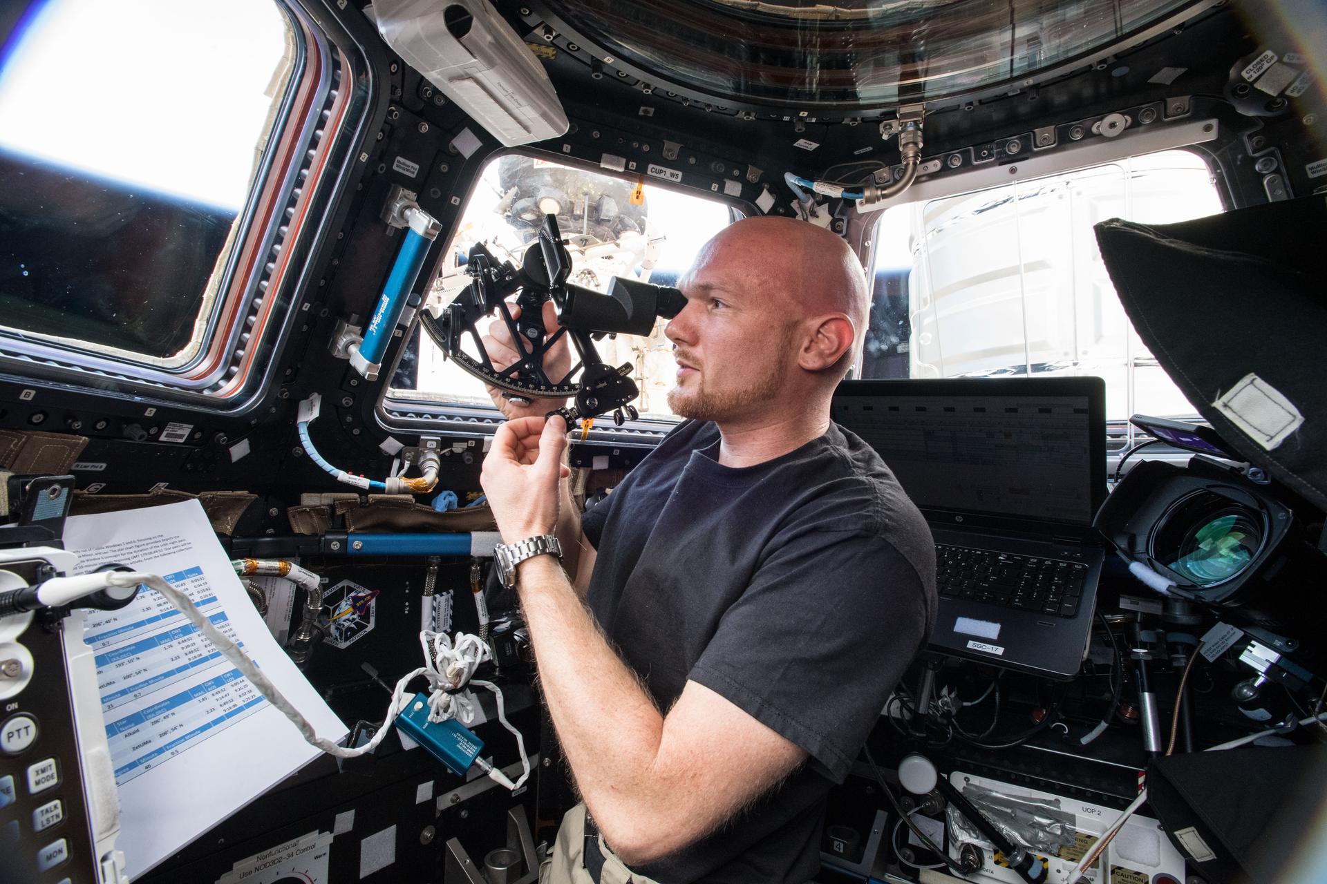
ESA astronaut Alexander Gerst operates the Sextant Navigation device.
NASA
Sextant Navigation tested star-sighting from space using a hand-held sextant. These mechanical devices measure the angle between two objects, typically the Sun or other stars at night and the horizon. Sextants guided navigators on Earth for centuries and NASA’s Gemini and Apollo missions demonstrated that they were useful in space as well, meaning they could provide emergency backup navigation for lunar missions. Researchers report that with minimal training and practice, crew members of different skill levels produced quality sightings through a station window and measurements improved with more use. The investigation identified several techniques for improving sightings, including refocusing between readings and adjusting the sight to the center of the window.
Navigating by neutron stars
The station’s NICER instrument studies the nature and behavior of neutron stars, the densest objects in the universe. Some neutron stars, known as pulsars, emit beams of light that appear to pulse, sweeping across the sky as the stars rotate. Some of them pulse at rates as accurate as atomic clocks. As part of the NICER investigation, the Station Explorer for X-ray Timing and Navigation Technology or SEXTANT tested technology for using pulsars in GPS-like systems to navigate anywhere in the solar system. SEXTANT successfully completed a first in-space demonstration of this technology in 2017. In 2018, researchers reported that real-time, autonomous X-ray pulsar navigation is clearly feasible and they plan further experiments to fine tune and modify the technology.
Robot navigation
Crews on future space exploration missions need efficient and safe ways to handle cargo and to move and assemble structures on the surface of the Moon or Mars. Robots are promising tools for these functions but must be able to navigate their surroundings, whether autonomously or via remote control, often in proximity with other robots and within the confines of a spacecraft. Several investigations have focused on improving navigation by robotic helpers.
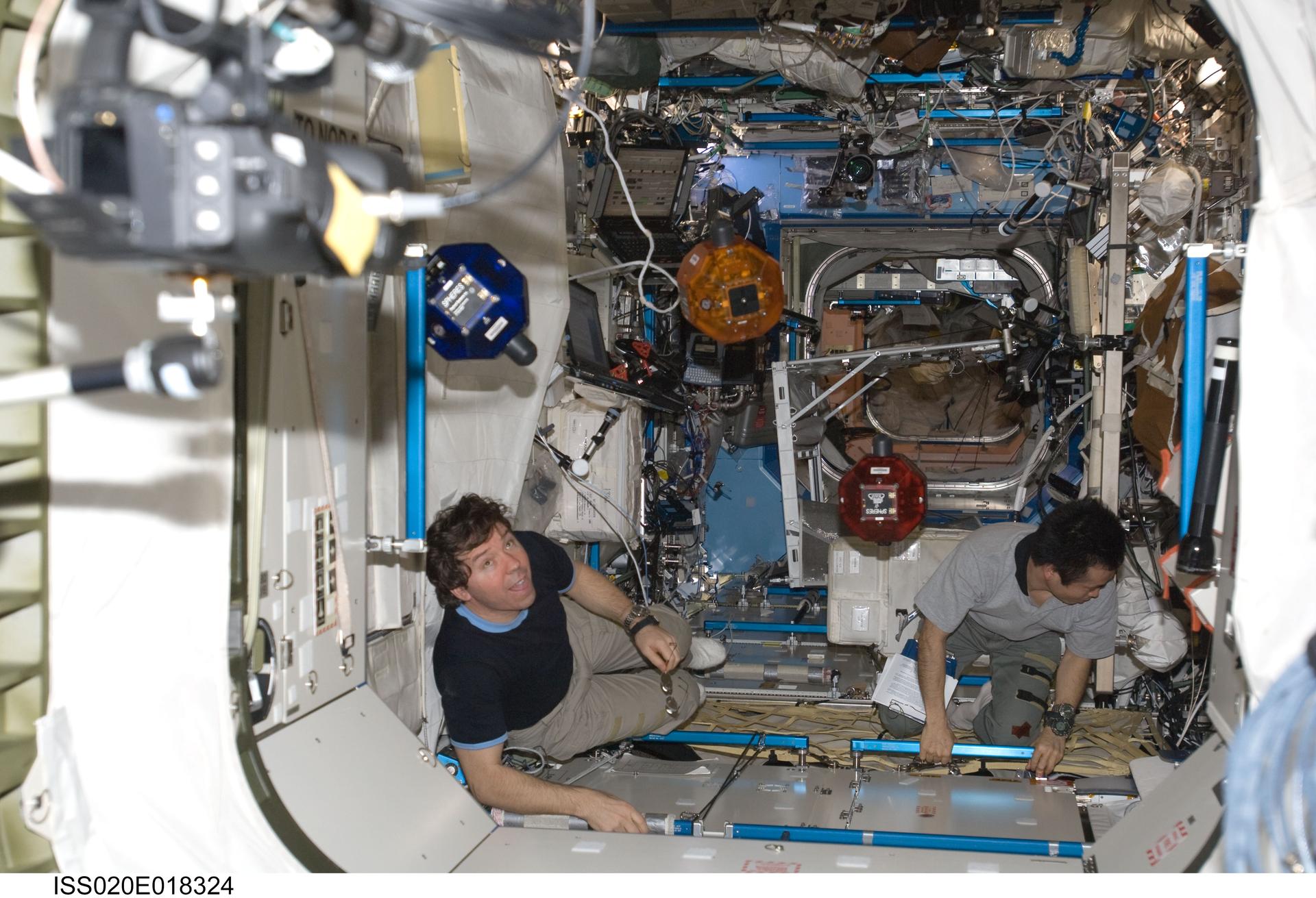
NASA astronaut Michael Barratt (left) and JAXA astronaut Koichi Wakata perform a check of the SPHERES robots.
NASA
The SPHERES investigation tested autonomous rendezvous and docking maneuvers with three spherical free-flying robots on the station. Researchers reported development of an approach to control how the robots navigate around obstacles and along a designated path, which could support their use in the future for satellite servicing, vehicle assembly, and spacecraft formation flying.
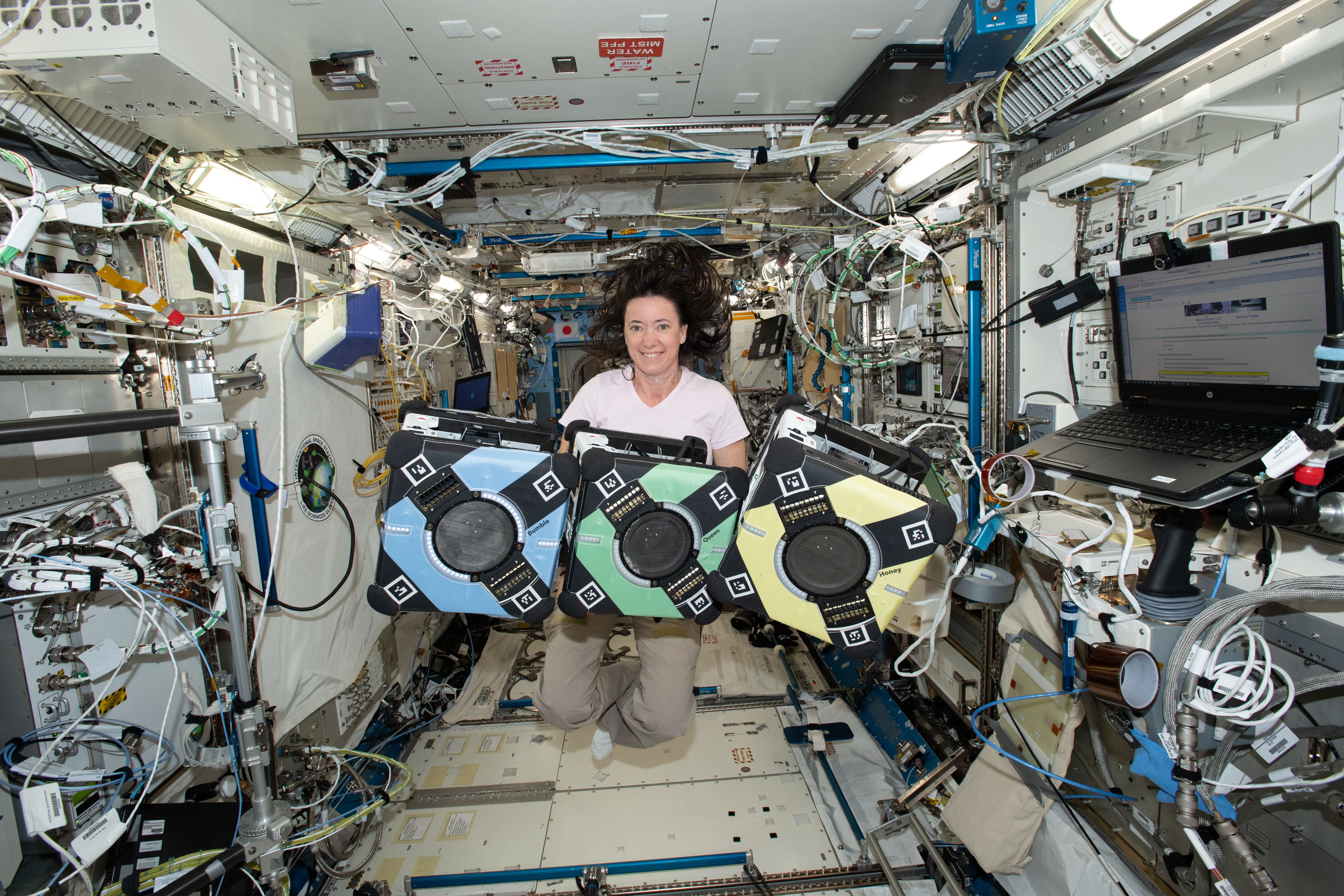
NASA astronaut Megan McArthur with the three Astrobee robots.
NASA
The station later gained three cube-shaped robots known as Astrobees. The ReSWARM experiments used them to test coordination of multiple robots with each other, cargo, and their environment. Results provide a base set of planning and control tools for robotic navigation in close proximity and outline important considerations for the design of future autonomous free-flyers.
Researchers also used the Astrobees to show that models to predict the robots’ behavior could make it possible to maneuver one or two of them for carrying cargo. This finding suggests that robots can navigate around each other to perform tasks without a human present, which would increase their usefulness on future missions.
ESA astronaut Samantha Cristoforetti working on the Surface Avatar experiment.
ESA
An investigation from ESA (European Space Agency), Surface Avatar evaluated orbit-to-ground remote control of multiple robots. Crew members successfully navigated a four-legged robot, Bert, through a simulated Mars environment. Robots with legs rather than wheels could explore uneven lunar and planetary surfaces that are inaccessible to wheeled rovers. The German Aerospace Center is developing Bert.
Preparations for Next Moonwalk Simulations Underway (and Underwater)
The C-20A aircraft, based at NASA’s Armstrong Flight Research Center in Edwards, California, flies over the Sierra Nevada Mountains in California for the Dense UAVSAR Snow Time (DUST) mission on Feb. 28, 2025. The DUST mission collected airborne data about snow water to help improve water management and reservoir systems on the ground.
NASA/Starr Ginn
As part of a science mission tracking one of Earth’s most precious resources – water – NASA’s C-20A aircraft conducted a series of seven research flights in March that can help researchers track the process and timeline as snow melts and transforms into a freshwater resource. The agency’s Uninhabited Aerial Vehicle Synthetic Aperture Radar (UAVSAR) installed on the aircraft collected measurements of seasonal snow cover and estimate the freshwater contained in it.
“Seasonal snow is a critical resource for drinking water, power generation, supporting multi-billion dollar agricultural and recreation industries,” said Starr Ginn, C-20A project manager at NASA’s Armstrong Flight Research Center in Edwards, California. “Consequently, understanding the distribution of seasonal snow storage and subsequent runoff is essential.”
The Dense UAVSAR Snow Time (DUST) mission mapped snow accumulation over the Sierra Nevada mountains in California and the Rocky Mountains in Idaho. Mission scientists can use these observations to estimate the amount of water stored in that snow.
Peter Wu, radar operator from NASA’s Jet Propulsion Laboratory in Southern California, observes data collected during the Dense UAVSAR Snow Time (DUST) mission onboard NASA’s C-20A aircraft on Feb. 28, 2025. The C-20A flew from NASA’s Armstrong Flight Research Center in Edwards, California, over the Sierra Nevada Mountains to collect data about snow water.
NASA/Starr Ginn
“Until recently, defining the best method for accurately measuring snow water equivalent (SWE) – or how much and when fresh water is converted from snow – has been a challenge,” said Shadi Oveisgharan, principal investigator of DUST and scientist at NASA’s Jet Propulsion Laboratory in Southern California. “The UAVSAR has been shown to be a good instrument to retrieve SWE data.”
Recent research has shown that snow properties, weather patterns, and seasonal conditions in the American West have been shifting in recent decades. These changes have fundamentally altered previous expectations about snowpack monitoring and forecasts of snow runoff. The DUST mission aims to better track and understand those changes to develop more accurate estimates of snow-to-water conversions and their timelines.
“We are trying to find the optimum window during which to retrieve snow data,” Oveisgharan said. “This estimation will help us better estimate available fresh snow and manage our reservoirs better.”
The Dense UAVSAR Snow Time (DUST) mission team assembles next to the C-20A aircraft at NASA’s Armstrong Flight Research Center in Edwards, California, on Feb. 28, 2025. From left, radar operator Adam Vaccaro, avionics lead Kelly Jellison, C-20A project manager Starr Ginn, pilot Carrie Worth, pilot Troy Asher, aircraft mechanic Eric Apikian, and operations engineer Ian Elkin.
NASA/Starr Ginn
The DUST mission achieved a new level of snow data accuracy, which is partly due to the specialized flight paths flown by the C-20A. The aircraft’s Platform Precision Autopilot (PPA) enables the team to fly very specific routes at exact altitudes, speeds, and angles so the UAVSAR can more precisely measure terrain changes.
“Imagine the rows made on grass by a lawn mower,” said Joe Piotrowski Jr., operations engineer for NASA Armstrong’s airborne science program. “The PPA system enables the C-20A to make those paths while measuring terrain changes down to the diameter of a centimeter.”
NASA Marshall Fires Up Hybrid Rocket Motor to Prep for Moon Landings
NASA’s Artemis campaign will use human landing systems, provided by SpaceX and Blue Origin, to safely transport crew to and from the surface of the Moon, in preparation for future crewed missions to Mars. As the landers touch down and lift off from the Moon, rocket exhaust plumes will affect the top layer of lunar “soil,” called regolith, on the Moon. When the lander’s engines ignite to decelerate prior to touchdown, they could create craters and instability in the area under the lander and send regolith particles flying at high speeds in various directions.
To better understand the physics behind the interaction of exhaust from the commercial human landing systems and the Moon’s surface, engineers and scientists at NASA’s Marshall Space Flight Center in Huntsville, Alabama, recently test-fired a 14-inch hybrid rocket motor more than 30 times. The 3D-printed hybrid rocket motor, developed at Utah State University in Logan, Utah, ignites both solid fuel and a stream of gaseous oxygen to create a powerful stream of rocket exhaust.
“Artemis builds on what we learned from the Apollo missions to the Moon. NASA still has more to learn more about how the regolith and surface will be affected when a spacecraft much larger than the Apollo lunar excursion module lands, whether it’s on the Moon for Artemis or Mars for future missions,” said Manish Mehta, Human Landing System Plume & Aero Environments discipline lead engineer. “Firing a hybrid rocket motor into a simulated lunar regolith field in a vacuum chamber hasn’t been achieved in decades. NASA will be able to take the data from the test and scale it up to correspond to flight conditions to help us better understand the physics, and anchor our data models, and ultimately make landing on the Moon safer for Artemis astronauts.”
Fast Facts
Over billions of years, asteroid and micrometeoroid impacts have ground up the surface of the Moon into fragments ranging from huge boulders to powder, called regolith.
Regolith can be made of different minerals based on its location on the Moon. The varying mineral compositions mean regolith in certain locations could be denser and better able to support structures like landers.
Of the 30 test fires performed in NASA Marshall’s Component Development Area, 28 were conducted under vacuum conditions and two were conducted under ambient pressure. The testing at Marshall ensures the motor will reliably ignite during plume-surface interaction testing in the 60-ft. vacuum sphere at NASA’s Langley Research Center in Hampton, Virginia, later this year.
Once the testing at NASA Marshall is complete, the motor will be shipped to NASA Langley. Test teams at NASA Langley will fire the hybrid motor again but this time into simulated lunar regolith, called Black Point-1, in the 60-foot vacuum sphere. Firing the motor from various heights, engineers will measure the size and shape of craters the rocket exhaust creates as well as the speed and direction the simulated lunar regolith particles travel when the rocket motor exhaust hits them.
“We’re bringing back the capability to characterize the effects of rocket engines interacting with the lunar surface through ground testing in a large vacuum chamber — last done in this facility for the Apollo and Viking programs. The landers going to the Moon through Artemis are much larger and more powerful, so we need new data to understand the complex physics of landing and ascent,” said Ashley Korzun, principal investigator for the plume-surface interaction tests at NASA Langley. “We’ll use the hybrid motor in the second phase of testing to capture data with conditions closely simulating those from a real rocket engine. Our research will reduce risk to the crew, lander, payloads, and surface assets.”
Credit: NASA
Through the Artemis campaign, NASA will send astronauts to explore the Moon for scientific discovery, economic benefits, and to build the foundation for the first crewed missions to Mars – for the benefit of all.
The New York Stock Exchange welcomed team members from NASA’s SPHEREx (Spectro-Photometer for the History of the Universe, Epoch of Reionization and Ices Explorer) mission to celebrate the launch of the agency’s newest astrophysics observatory to understand the origins and structure of the universe.
Image courtesy of NYSE Group
Members of NASA’s recently launched SPHEREx (Spectro-Photometer for the History of the Universe, Epoch of Reionization and Ices Explorer) mission team participated in the New York Stock Exchange’s closing bell ceremony in New York City on April 22.
Michael Thelen, SPHEREx flight system manager at NASA’s Jet Propulsion Laboratory in Southern California, is seen here ringing the closing bell. Additional SPHEREx team members from NASA JPL, which manages the mission, and BAE Systems Inc., Space & Mission Systems, which built the telescope and spacecraft bus for NASA, participated.
The SPHEREx observatory, which launched March 11 from Vandenberg Space Force Base in California on a SpaceX Falcon 9 rocket, will soon begin mapping the universe like none before it. Using 102 color filters to scan the entire sky quickly, SPHEREx will gather data on hundreds of millions of galaxies that will complement the work of more targeted telescopes, like NASA’s Hubble and James Webb space telescopes. Its surveys will help answer some of the biggest questions in astrophysics: what happened in the first second after the big bang, how galaxies form and evolve, and the origins and abundance of water and other key ingredients for life in our galaxy.
Michael P. Thelen, SPHEREx Observatory Flight System Manager, rings the bell alongside NASA SPHEREx team members at the New York Stock Exchange Tuesday, April 25, 2025.
Image courtesy of NYSE Group
More About SPHEREx
SPHEREx is managed by JPL for NASA’s Astrophysics Division within the Science Mission Directorate in Washington. BAE Systems (formerly Ball Aerospace) built the telescope and the spacecraft bus. The science analysis of the SPHEREx data will be conducted by a team of scientists located at 10 institutions across the U.S. and in South Korea. Data will be processed and archived at IPAC at Caltech, which manages JPL for NASA. The mission principal investigator is based at Caltech with a joint JPL appointment. The SPHEREx dataset will be publicly available.
This website uses cookies to improve your experience. We'll assume you're ok with this, but you can opt-out if you wish.AcceptRead More
Privacy & Cookies Policy
Privacy Overview
This website uses cookies to improve your experience while you navigate through the website. Out of these, the cookies that are categorized as necessary are stored on your browser as they are essential for the working of basic functionalities of the website. We also use third-party cookies that help us analyze and understand how you use this website. These cookies will be stored in your browser only with your consent. You also have the option to opt-out of these cookies. But opting out of some of these cookies may affect your browsing experience.
Necessary cookies are absolutely essential for the website to function properly. This category only includes cookies that ensures basic functionalities and security features of the website. These cookies do not store any personal information.
Any cookies that may not be particularly necessary for the website to function and is used specifically to collect user personal data via analytics, ads, other embedded contents are termed as non-necessary cookies. It is mandatory to procure user consent prior to running these cookies on your website.