Modular Assembled Radiators for Nuclear Electric Propulsion Vehicles, or MARVL, aims to take a critical element of nuclear electric propulsion, its heat dissipation system, and divide it into smaller components that can be assembled robotically and autonomously in space. This is an artist’s rendering of what the fully assembled system might look like.
NASA
The trip to Mars and back is not one for the faint of heart. We’re not talking days, weeks, or months. But there are technologies that could help transport a crew on that round-trip journey in a relatively quick two years.
One option NASA is exploring is nuclear electric propulsion, which employs a nuclear reactor to generate electricity that ionizes, or positively charges, and electrically accelerates gaseous propellants to provide thrust to a spacecraft.
Researchers at NASA’s Langley Research Center in Hampton, Virginia, are working on a system that could help bring nuclear electric propulsion one significant, technology-defining step closer to reality.
Modular Assembled Radiators for Nuclear Electric Propulsion Vehicles, or MARVL, aims to take a critical element of nuclear electric propulsion, its heat dissipation system, and divide it into smaller components that can be assembled robotically and autonomously in space.
“By doing that, we eliminate trying to fit the whole system into one rocket fairing,” said Amanda Stark, a heat transfer engineer at NASA Langley and the principal investigator for MARVL. “In turn, that allows us to loosen up the design a little bit and really optimize it.”
Loosening up the design is key, because as Stark mentioned, previous ideas called for fitting the entire nuclear electric radiator system under a rocket fairing, or nose cone, which covers and protects a payload. Fully deployed, the heat dissipating radiator array would be roughly the size of a football field. You can imagine the challenge engineers would face in getting such a massive system folded up neatly inside the tip of a rocket.
The MARVL technology opens a world of possibilities. Rather than cram the whole system into an existing rocket, this would allow researchers the flexibility to send pieces of the system to space in whatever way would make the most sense, then have it all assembled off the planet.
Once in space, robots would connect the nuclear electric propulsion system’s radiator panels, through which a liquid metal coolant, such as a sodium-potassium alloy, would flow.
While this is still an engineering challenge, it is exactly the kind of engineering challenge in-space-assembly experts at NASA Langley have been working on for decades. The MARVL technology could mark a significant first milestone. Rather than being an add-on to an existing technology, the in-space assembly component will benefit and influence the design of the very spacecraft it would serve.
“Existing vehicles have not previously considered in-space assembly during the design process, so we have the opportunity here to say, ‘We’re going to build this vehicle in space. How do we do it? And what does the vehicle look like if we do that?’ I think it’s going to expand what we think of when it comes to nuclear propulsion,” said Julia Cline, a mentor for the project in NASA Langley’s Research Directorate, who led the center’s participation in the Nuclear Electric Propulsion tech maturation plan development as a precursor to MARVL. That tech maturation plan was run out of the agency’s Space Nuclear Propulsion project at Marshall Space Flight Center in Huntsville, Alabama.
NASA’s Space Technology Mission Directorate awarded the MARVL project through the Early Career Initiative, giving the team two years to advance the concept. Stark and her teammates are working with an external partner, Boyd Lancaster, Inc., to develop the thermal management system. The team also includes radiator design engineers from NASA’s Glenn Research Center in Cleveland and fluid engineers from NASA’s Kennedy Space Center in Florida. After two years, the team hopes to move the MARVL design to a small-scale ground demonstration.
The idea of robotically building a nuclear propulsion system in space is sparking imaginations.
“One of our mentors remarked, ‘This is why I wanted to work at NASA, for projects like this,’” said Stark, “which is awesome because I am so happy to be involved with it, and I feel the same way.”
Additional support for MARVL comes from the agency’s Space Nuclear Propulsion project. The project’s ongoing effort is maturing technologies for operations around the Moon and near-Earth exploration, deep space science missions, and human exploration using nuclear electric propulsion and nuclear thermal propulsion.
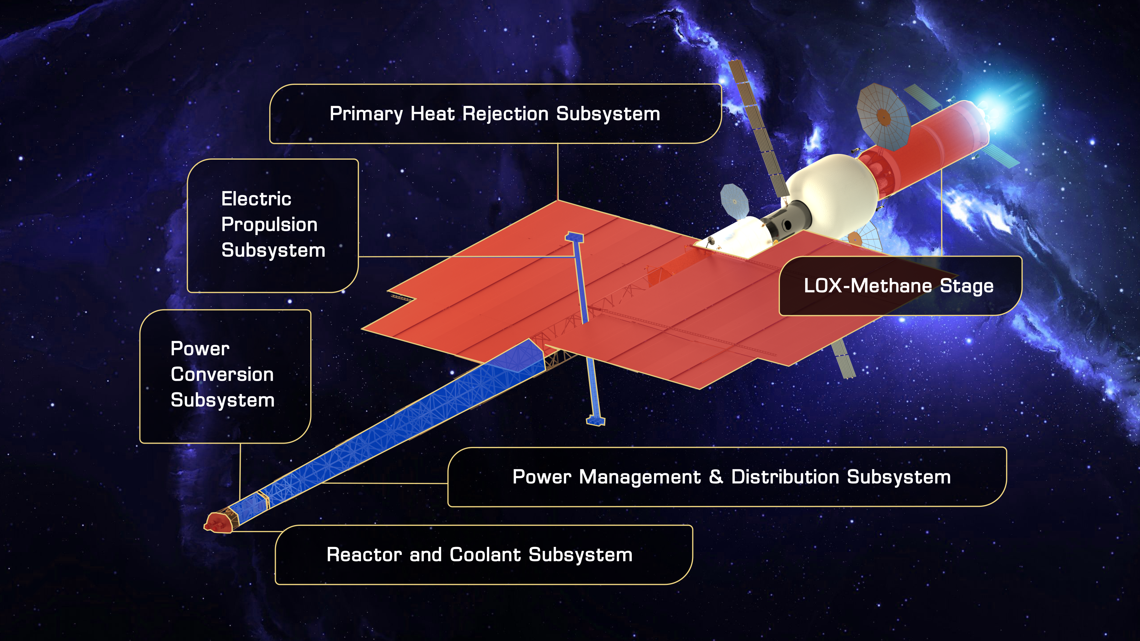
An artist’s rendering that shows the different components of a fully assembled nuclear electric propulsion system.
Preparations for Next Moonwalk Simulations Underway (and Underwater)
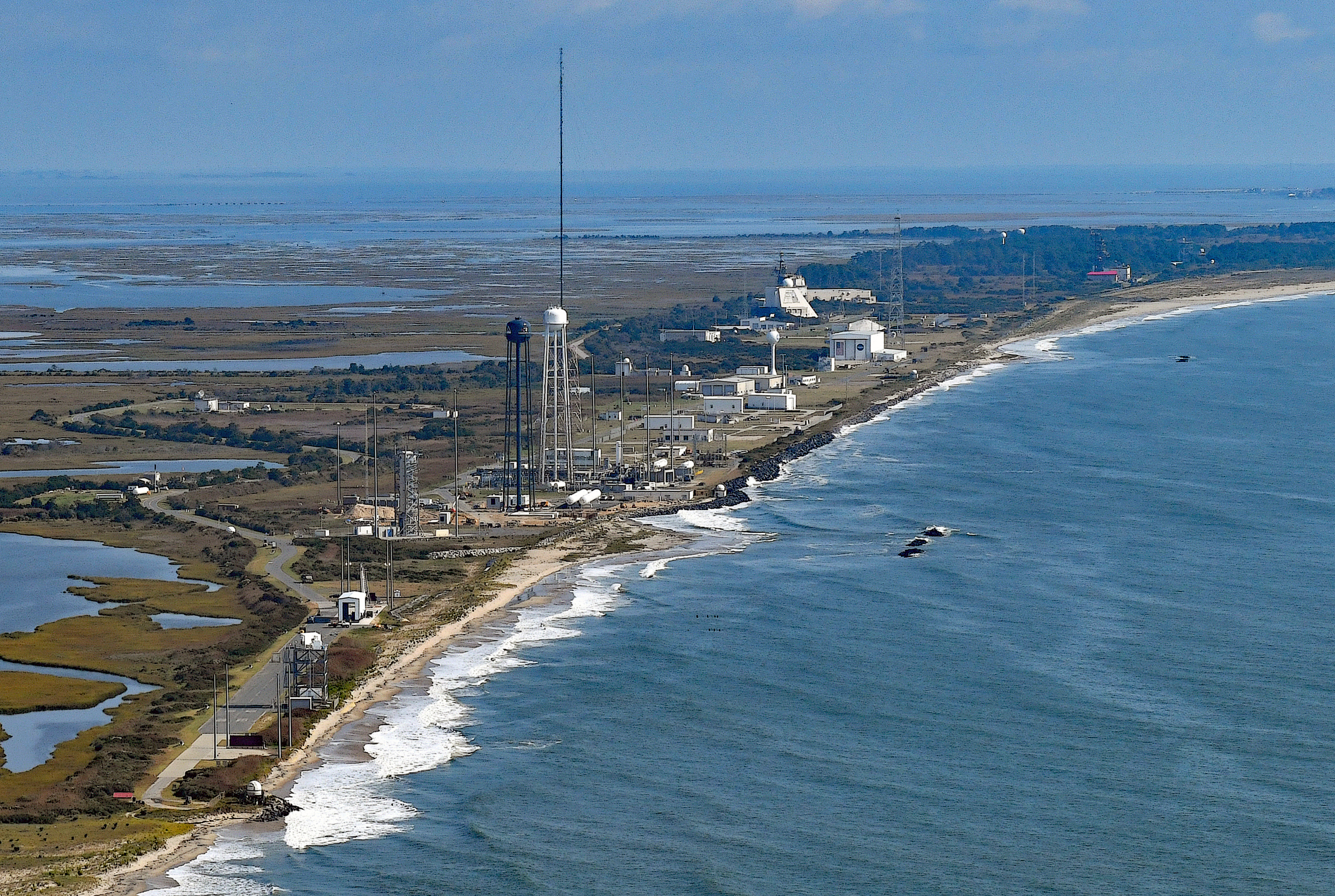
This September 2024 aerial photograph shows the coastal launch range at NASA’s Wallops Flight Facility on Virginia’s Eastern Shore. Wallops is the agency’s only owned-and-operated launch range.
Courtesy Patrick J. Hendrickson; used with permission
A suborbital rocket is scheduled to launch from NASA’s Wallops Flight Facility in Virginia during a window extending from Monday, Jan. 13, through Thursday, Jan. 16. This launch supports the Missile Defense Agency, Naval Surface Warfare Center, Port Hueneme Division’s White Sands Detachment, and other Department of Defense organizations.
No real-time launch status updates will be available. The launch will not be livestreamed, and updates will not be provided during the countdown. The rocket launch may be visible from the Chesapeake Bay region.
This map of Earth in 2024 shows global surface temperature anomalies, or how much warmer or cooler each region of the planet was compared to the average from 1951 to 1980. Normal temperatures are shown in white, higher-than-normal temperatures in red and orange, and lower-than-normal temperatures in blue. An animated version of this map shows global temperature anomalies changing over time, dating back to 1880. Download this visualization from NASA Goddard’s Scientific Visualization Studio: https://svs.gsfc.nasa.gov/5450.
Earth’s average surface temperature in 2024 was the warmest on record, according to an analysis led by NASA scientists.
Global temperatures in 2024 were 2.30 degrees Fahrenheit (1.28 degrees Celsius) above the agency’s 20th-century baseline (1951-1980), which tops the record set in 2023. The new record comes after 15 consecutive months (June 2023 through August 2024) of monthly temperature records — an unprecedented heat streak.
“Once again, the temperature record has been shattered — 2024 was the hottest year since record keeping began in 1880,” said NASA Administrator Bill Nelson. “Between record breaking temperatures and wildfires currently threatening our centers and workforce in California, it has never been more important to understand our changing planet.”
NASA scientists further estimate Earth in 2024 was about 2.65 degrees Fahrenheit (1.47 degrees Celsius) warmer than the mid-19th century average (1850-1900). For more than half of 2024, average temperatures were more than 1.5 degrees Celsius above the baseline, and the annual average, with mathematical uncertainties, may have exceeded the level for the first time.
“The Paris Agreement on climate change sets forth efforts to remain below 1.5 degrees Celsius over the long term. To put that in perspective, temperatures during the warm periods on Earth three million years ago — when sea levels were dozens of feet higher than today — were only around 3 degrees Celsius warmer than pre-industrial levels,” said Gavin Schmidt, director of NASA’s Goddard Institute for Space Studies (GISS) in New York. “We are halfway to Pliocene-level warmth in just 150 years.”
2024 was Earth’s warmest year since modern record-keeping began around 1880, and the past 10 consecutive years have been the warmest 10 on record. Credit: NASA/Grace Weikert
Scientists have concluded the warming trend of recent decades is driven by heat-trapping carbon dioxide, methane, and other greenhouse gases. In 2022 and 2023, Earth saw record increases in carbon dioxide emissions from fossil fuels, according to a recent international analysis. The concentration of carbon dioxide in the atmosphere has increased from pre-industrial levels in the 18th century of approximately 278 parts per million to about 420 parts per million today.
NASA and other federal agencies regularly collect data on greenhouse gas concentrations and emissions. These data are available at the U.S. Greenhouse Gas Center, a multi-agency effort that consolidates information from observations and models, with a goal of providing decision-makers with one location for data and analysis.
Exceptional heat trends
The temperatures of individual years can be influenced by natural climate fluctuations such as El Niño and La Niña, which alternately warm and cool the tropical Pacific Ocean. The strong El Niño that began in fall 2023 helped nudge global temperatures above previous records.
This data visualization, which is updated monthly, shows monthly global temperature anomalies on Earth’s surface, and how those temperatures deviate from the average from 1951 to 1980. Download this visualization from NASA Goddard’s Scientific Visualization Studio: https://svs.gsfc.nasa.gov/5190.
Credit: NASA’s Scientific Visualization Studio
The heat surge that began in 2023 continued to exceed expectations in 2024, Schmidt said, even though El Niño abated. Researchers are working to identify contributing factors, including possible climate impacts of the January 2022 Tonga volcanic eruption and reductions in pollution, which may change cloud cover and how solar energy is reflected back into space.
“Not every year is going to break records, but the long-term trend is clear,” Schmidt said. “We’re already seeing the impact in extreme rainfall, heat waves, and increased flood risk, which are going to keep getting worse as long as emissions continue.”
Seeing changes locally
NASA assembles its temperature record using surface air temperature data collected from tens of thousands of meteorological stations, as well as sea surface temperature data acquired by ship- and buoy-based instruments. This data is analyzed using methods that account for the varied spacing of temperature stations around the globe and for urban heating effects that could skew the calculations.
A new assessment published earlier this year by scientists at the Colorado School of Mines, National Science Foundation, the National Atmospheric and Oceanic Administration (NOAA), and NASA further increases confidence in the agency’s global and regional temperature data.
“When changes happen in the climate, you see it first in the global mean, then you see it at the continental scale and then at the regional scale. Now, we’re seeing it at the local level,” Schmidt said. “The changes occurring in people’s everyday weather experiences have become abundantly clear.”
Independent analyses by NOAA, Berkeley Earth, the Hadley Centre (part of the United Kingdom’s weather forecasting Met Office) and Copernicus Climate Services in Europe have also concluded that the global surface temperatures for 2024 were the highest since modern record-keeping began. These scientists use much of the same temperature data in their analyses but use different methodologies and models. Each shows the same ongoing warming trend.
NASA’s full dataset of global surface temperatures, as well as details of how NASA scientists conducted the analysis, are publicly available from GISS, a NASA laboratory managed by the agency’s Goddard Space Flight Center in Greenbelt, Maryland.
For more information about NASA’s Earth science programs, visit:
On Jan. 9, 1990, space shuttle Columbia took off on its ninth flight, STS-32, from NASA’s Kennedy Space Center (KSC) in Florida. Its five-person crew of Commander Daniel Brandenstein, Pilot James Wetherbee, and Mission Specialists Bonnie Dunbar, Marsha Ivins, and David Low flew a then record-breaking 11-day mission to deploy the Syncom IV-F5 communications satellite for the U.S. Navy and retrieve the Long-Duration Exposure Facility (LDEF). Astronauts aboard a shuttle mission in 1984 deployed the LDEF and scientists eagerly awaited the return of their 57 experiments to study the effects of nearly six years exposure to the low Earth orbit environment. The crew also conducted several middeck experiments in biotechnology and materials processing and used an echocardiograph to study changes in their hearts.
The STS-32 crew of Mission Specialist Bonnie Dunbar, left, Commander Daniel Brandenstein, Pilot James Wetherbee, and Mission Specialists Marsha Ivins and David Low.
The STS-32 crew patch.
The Long Duration Exposure Facility during its deployment on the STS-41C mission in 1984.
In November 1988, NASA announced Brandenstein, Wetherbee, Dunbar, Ivins, and Low as the STS-32 crew for the flight then planned for November 1989. Brandenstein, from the Class of 1978, had flown twice before, as pilot on STS-8 in August-September 1983 and commander of STS-51G in June 1985. Dunbar, selected in 1980, had flown once before on STS-61A in October-November 1985. For Wetherbee, Ivins, and Low, all selected in 1984, STS-32 marked their first spaceflight. During the second day of their planned 10-day mission, the astronauts would deploy the Syncom IV-F5, also known as Leasat-5, communications satellite for the U.S. Navy. The main focus of the flight involved the retrieval of LDEF, deployed by the STS-41C crew in April 1984. The original plan had LDEF, containing 57 science and technology experiments, retrieved by the STS-51D crew in February 1985. Delays in the shuttle program first pushed the retrieval to STS-61I in September 1986, and then the Challenger accident delayed it to STS-32. The facility ended up staying in orbit nearly six years instead of the originally intended 10 months. The crew rounded out the mission by conducting a series of middeck science and medical experiments.
Space shuttle Columbia rolls out to its launch pad on a foggy morning.
NASA scientist John Charles, at rear, trains astronauts David Low, left, and Bonnie Dunbar, supine, in the operation of a cardiovascular experiment.
The STS-32 crew exits crew quarters for the ride to Launch Pad 39A.
Columbia returned to KSC on Aug. 21, 1989, following STS-28’s landing at Edwards Air Force Base (AFB) in California, and workers towed it to the Orbiter Processing Facility (OPF) the next day. They made 26 modifications to the orbiter, including the installation of the Remote Manipulator System (RMS), or robotic arm, and a fifth set of liquid hydrogen and liquid oxygen tanks to extend the vehicle’s duration in space. Rollover to the nearby Vehicle Assembly Building took place on Nov. 16, where Columbia joined its External Tank and twin Solid Rocket Boosters (SRB) on refurbished Mobile Launch Platform 3, last used in 1975. Rollout took place on Nov. 28 to Launch Pad 39A, newly refurbished since its previous launch in 1986.
On Dec. 1, engineers and the astronaut crew completed the Terminal Countdown Demonstration Test, a dress rehearsal for the planned Dec. 18 launch. Based on that date and the mission’s planned 10-day duration, the STS-32 crew would have spent Christmas in space, only the third American crew and the first space shuttle crew to do so. However, unfinished work on Pad 39A delayed the launch into January 1990. Trajectory specialists had estimated that due to orbital decay, LDEF would reenter the Earth’s atmosphere by March 1990, so a timely launch remained crucial for mission success. The countdown began on Jan. 4 for an expected Jan. 8 launch, with the crew arriving at KSC on Jan. 5.
Liftoff of space shuttle Columbia on STS-32.
The deployment of the Syncom IV-F5 satellite.
Syncom following deployment.
Cloudy skies scrubbed the first launch attempt on Jan. 8. Liftoff took place the next day at 7:35 a.m. EST from Launch Pad 39A, with LDEF 1,500 miles ahead of Columbia. The powered ride to space took 8.5 minutes, placing Columbia into a 215-by-38-mile orbit. A burn of the two Orbiter Maneuvering System (OMS) engines 40 minutes later changed the orbit to the desired 222-by-180-mile altitude. The crew opened the shuttle’s payload bay doors and deployed its radiators. The major activities for the first day in space involved the checkout of the RMS and the first rendezvous maneuver in preparation for the LDEF grapple three days later. The astronauts also activated four of the middeck experiments. On the mission’s second day, Low deployed the 15,000-pound Syncom satellite, releasing it in a frisbee motion out of the payload bay. The satellite extended its antenna, stabilized itself, and 40 minutes after deployment, fired its engine for the first burn to send it to its geostationary orbit.
The Long Duration Exposure Facility (LDEF) during the rendezvous.
STS-32 astronaut Bonnie Dunbar has grappled LDEF with the Remote Manipulator System.
Dunbar lowers LDEF into the payload bay.
Following the Syncom deploy, the crew turned its attention to the rendezvous with LDEF while also continuing the middeck experiments. On Flight Day 3, they completed three rendezvous burns as they steadily continued their approach to LDEF. Soon after awakening on Flight Day 4, the astronauts spotted LDEF appearing as a bright star. After the first of four rendezvous burns, Columbia’s radar locked onto the satellite. As they continued the approach, with three more burns carried out successfully, Dunbar activated the RMS in preparation for the upcoming grapple. Brandenstein took over manual control of Columbia for the final approach and parked the shuttle close enough to LDEF for Dunbar to reach out with the 50-foot arm and grapple the satellite. Brandenstein reported, “We have LDEF.”
For the next four hours, with Wetherbee flying the orbiter and Dunbar operating the arm, Ivins performed a comprehensive photo survey of LDEF, documenting the effects of nearly six years of space exposure on the various experiments. The survey completed, Dunbar slowly and carefully lowered LDEF into the payload bay, and five latches secured it in place for the ride back to Earth. With the two major goals of their mission completed, the astronauts settled down for the remainder of their 10-day mission conducting science experiments.
With astronaut David Low acting as an operator, astronaut Bonnie Dunbar serves as a subject for a cardiovascular experiment.
Astronaut Marsha Ivins with several cameras testing the effects of spaceflight on different types of film.
During the mission, the STS-32 crew conducted several middeck experiments. The Protein Crystal Growth experiment used vapor diffusion to grow 120 crystals of 24 different proteins, for study by scientists following their return to Earth. The Characterization of Neurospora Circadian Rhythm experiment studied whether spaceflight affected the daily cycles of pink bread mold. The Fluid Experiment Apparatus performed materials processing research in the microgravity environment. The astronauts used the American Flight Echocardiograph (AFE) to study changes in their hearts as a result of weightlessness. The crew used the large format IMAX camera to film scenes inside the cabin as well as through the windows, such as the capture of LDEF.
Astronaut Daniel Brandenstein holds an inflatable plastic cake given to him by his crew mates in honor of his birthday.
The STS-32 crew poses in Columbia’s middeck.
On Jan. 17, Brandenstein celebrated his 47th birthday, the fifth American astronaut to do so in space. His crew presented him with an inflatable plastic cake including candles while controllers in Mission Control passed on their birthday wishes as did his wife and teenage daughter. On the same day, NASA announced the selection of its 13th group of astronauts. Among them, engineer Ronald Sega, Dunbar’s husband, as well as the first female shuttle pilot, Eileen Collins, and the first Hispanic woman astronaut, Ellen Ochoa.
Columbia touches down at Edwards Air Force Base in California.
At the welcome home ceremony at Ellington Field in Houston, director of NASA’s Johnson Space Center Aaron Cohen addresses the crowd as the STS-32 astronauts and their families listen.
On Jan. 19, the astronauts awakened for their planned final day in space. However, due to fog at their landing site, Edwards AFB in California, Mission Control first informed them that they would have to spend an extra orbit in space, and finally decided to delay the landing by an entire day. With their experiments already packed, the crew spent a quiet day, looking at the Earth and using up what film still remained. As they slept that night, they passed the record for the longest space shuttle mission, set by STS-9 in 1983.
In preparation for reentry, the astronauts donned their orange spacesuits and closed the payload bay doors. A last-minute computer problem delayed reentry by one orbit, then Brandenstein and Wetherbee oriented Columbia into the deorbit attitude, with the OMS engines facing in the direction of travel. Over the Indian Ocean, they fired the two engines for 2 minutes 48 seconds to bring the spacecraft out of orbit. They reoriented the orbiter to fly with its heat shield exposed to the direction of flight as it encountered Earth’s atmosphere at 419,000 feet. The buildup of ionized gases caused by the heat of reentry prevented communications for about 15 minutes but provided the astronauts a great light show. After completing the Heading Alignment Circle turn, Brandenstein aligned Columbia with the runway, and Wetherbee lowered the landing gear. Columbia touched down and rolled to a stop, making the third night landing of the shuttle program and ending a 10-day 21-hour 1-minute flight, the longest shuttle flight up to that time, having completed 172 orbits of the Earth.
Other records set by the astronauts on this mission included Brandenstein as the new record holder for most time spent in space by a shuttle crew member – 24 days – and Dunbar accumulating the most time in space by a woman – 18 days – up to that time. Following eight hours of postflight medical testing, the astronauts boarded a jet bound for Houston’s Ellington Field, where they reunited with their families and took part in a welcome home ceremony led by Aaron Cohen, director of NASA’s Johnson Space Center.
Columbia returns to NASA’s Kennedy Space Center in Florida atop the Shuttle Carrier Aircraft.
Workers lift the Long Duration Exposure Facility from Columbia’s payload bay.
Following postlanding inspections, workers placed Columbia, with LDEF still cradled in its payload bay, atop a Shuttle Carrier Aircraft, a modified Boeing-747, and the combination left Edwards on Jan. 25. Following a refueling stop at Monthan Davis AFB in Tucson, an overnight stay at Kelly AFB in San Antonio, and another refueling stop at Eglin AFB in Fort Walton Beach, Florida, Columbia and LDEF arrived back at KSC on Jan. 26. The next day, workers towed Columbia to the OPF and on Jan. 30 lifted LDEF out of its payload bay, in preparation for the detailed study of the effects of nearly six years in space on the 57 experiments it carried. Meanwhile, workers began to prepare Columbia for its next flight, STS-35 in December 1990.
Enjoy the crew narrate a video of the STS-32 mission. Read Brandenstein‘s and Dunbar‘s recollections of the STS-32 mission in their oral histories with the JSC History Office. For an overview of the LDEF project, enjoy this video. For detailed information on the results of the LDEF experiments, follow this link.
Preparations for Next Moonwalk Simulations Underway (and Underwater)
NASA/Lori Losey
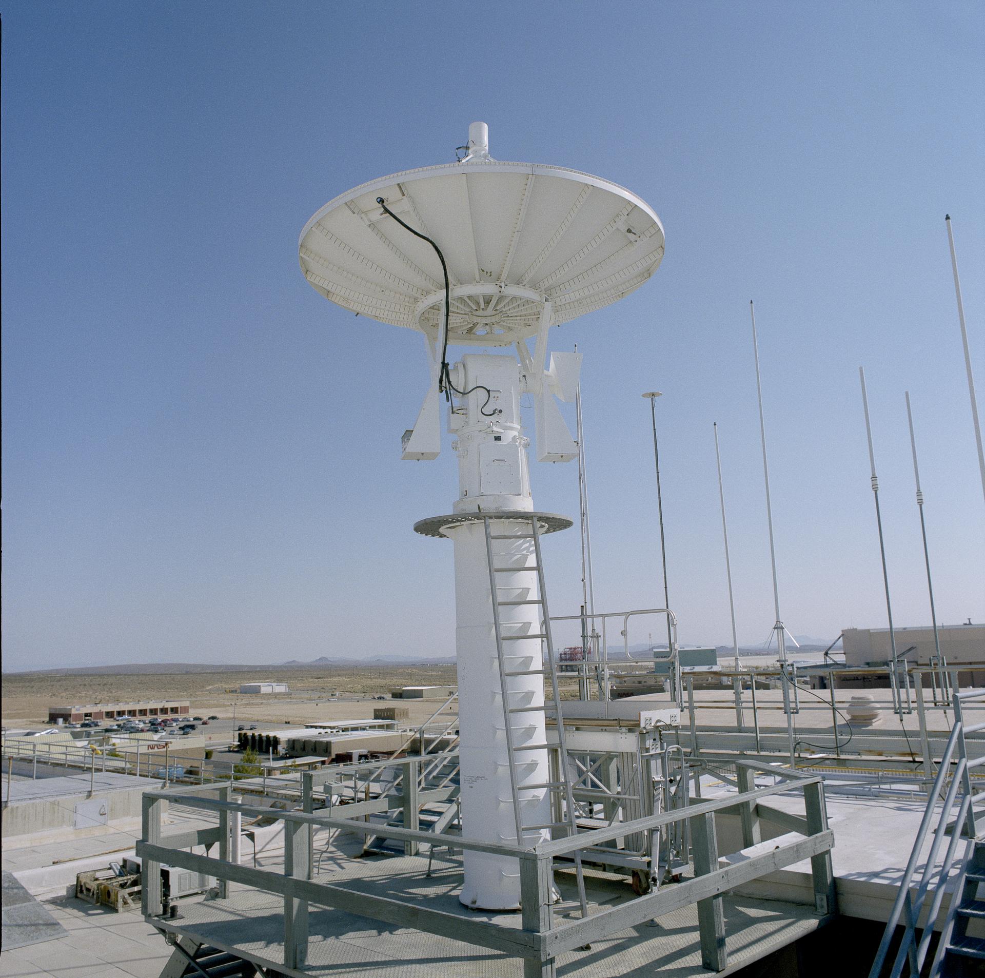
What do the X-15 and the space shuttles have in common? Information from the rocket plane and the spacecraft, as well as many experimental aircraft, were tracked from a pedestal and telemetry dish during key eras in flight history at or near NASA’s Armstrong Flight Research Center in Edwards, California.
When the NASA facility’s administration Building 4800 was built in the 1950s, the infrastructure was included to anchor the rooftop pedestal and dish as the primary way to gather data from aircraft during flights. It was retired in 2015, but a recent roofing project enabled relocation of the artifact to a new place of honor for its support of many experimental aircraft such as the lifting body aircraft, the reverse swept wing X-29, and the highly maneuverable X-31.
“Gathering telemetry data from aircraft on missions is at the core of what we do. Close proximity to the back ramp was one of the big advantages of having the telemetry antenna on the roof in the early days,” said Bob Guere, NASA Armstrong Range Operations chief, referring to the area where aircraft taxi from the hangar to the flightline. “You were able to support ground tests and check airplanes before they taxied without having to use telemetry antennas positioned further away.”
A cable is secured on a rooftop pedestal located on Building 4800 at NASA’s Armstrong Flight Research Center in Edwards, California, on Oct. 4, 2024. The pedestal, which was prepared for a helicopter lift to remove it from the roof, was used since the 1950s until 2015 to enable different telemetry dishes to collect data from research aircraft.
NASA/Carla Thomas
The rooftop pedestal was key in the early days of the center and its refurbishment in 2003 restored its value. The transformation also included certification to meet Space Shuttle Program landing requirements.
“When a space shuttle deorbited from space it was coming over the top of Edwards,” Guere said. “Telemetry antennas on the hill near NASA Armstrong looked down and with dirt and concrete in the background there were reflections. The rooftop antenna was closer to ground level and looked up as the orbiter was coming in for a landing. It provided an excellent link for shuttle landings.”
The pedestal and dish were not removed when it was decommissioned because of the cost. Now, it’s economical to use a helicopter to remove the pedestal from the roof compared to other options as part of a major project focusing primarily on re-roofing Building 4800. The helicopter lift of the pedestal took a month to plan, plus time to obtain airspace operation and landing permits from the Air Force for the removal project, said Bryan Watters, NASA Armstrong roof project manager.
A helicopter is positioned to remove a rooftop pedestal from Building 4800 at NASA’s Armstrong Flight Research Center in Edwards, California, on Oct. 4, 2024. The pedestal was used since the 1950s to 2015 to house different telemetry dishes to collect data from research aircraft.
NASA/Carla Thomas
The pedestal and riser measured 16 feet tall above the rooftop and housed an assembly for the 12-foot dish to rotate. The pedestal and dish together weight about 2,500 pounds and were removed separately. Crews checked the eight bolts anchoring the pedestal and dish to infrastructure on the roof prior to the arrival of a helicopter Oct. 3 before the helicopter arrived.
The following day, after additional briefings, the helicopter was positioned over Building 4800 and a cable was lowered and attached to the pedestal. Once secured, the helicopter slowly gained altitude and took its passenger to the south side of the building. There it was released from the cable and taken to a nearby warehouse for storage. Roofers demolished the steel platform on which the pedestal was located to prepare the area for new roofing materials.
Officials have not determined where the pedestal will be displayed. There are several options to place the pedestal and dish by the famous retired research aircraft on display near the entrance of NASA Armstrong.
A pedestal carried by a helicopter is positioned for a gentle placement on the ground. The helicopter removed the pedestal from the rooftop of Building 4800 at NASA’s Armstrong Flight Research Center in Edwards, California, on Oct. 4, 2024. The pedestal was used since the 1950s to 2015 to house different telemetry dishes to collect data from research aircraft.
NASA/Carla Thomas
A rooftop pedestal and telemetry dish gathered information from research aircraft at Building 4800 at NASA’s Armstrong Flight Research Center in Edwards, California. The pedestal was used since the 1950s to 2015 to house different dishes to collect data from research aircraft. On Oct. 4, 2024, a helicopter was used to remove the pedestal from the roof.
On Jan. 7, 1610, Italian astronomer Galileo Galilei peered through his newly improved 20-power homemade telescope at the planet Jupiter. He noticed three other points of light near the planet, at first believing them to be distant stars. Observing them over several nights, he noted that they appeared to move in the wrong direction with regard to the background stars and they remained in Jupiter’s proximity but changed their positions relative to one another. Four days later, he observed a fourth point of light near the planet with the same unusual behavior. By Jan. 15, Galileo correctly concluded that he had discovered four moons orbiting around Jupiter, providing strong evidence for the Copernican theory that most celestial objects did not revolve around the Earth.
Two of Galileo’s telescopes.
National Geographic.
Painting by Giuseppe Bertini (1858) of Galileo demonstrating his telescope to the Doge of Venice.
gabrielevanin.it
Page from Galileo’s notebook about his observations of Jupiter’s satellites.
University of Michigan Special Collections Library.
In March 1610, Galileo published his discoveries of Jupiter’s satellites and other celestial observations in a book titled Siderius Nuncius (The Starry Messenger). As their discoverer, Galileo had naming rights to Jupiter’s satellites. He proposed to name them after his patrons the Medicis and astronomers called them the Medicean Stars through much of the seventeenth century, although in his own notes Galileo referred to them by the Roman numerals I, II, III, and IV, in order of their distance from Jupiter. Astronomers still refer to the four moons as the Galilean satellites in honor of their discoverer.
In 1614, the German astronomer Johannes Kepler suggested naming the satellites after mythological figures associated with Jupiter, namely Io, Europa, Ganymede, and Callisto, but his idea didn’t catch on for more than 200 years. Scientists didn’t discover any more satellites around Jupiter until 1892 when American astronomer E.E. Barnard found Jupiter’s fifth moon Amalthea, much smaller than the Galilean moons and orbiting closer to the planet than Io. It was the last satellite in the solar system found by visual observation – all subsequent discoveries occurred via photography or digital imaging. As of today, astronomers have identified 95 moons orbiting Jupiter.
Image of Jupiter and three of its four Galilean satellites through an amateur telescope, similar to what Galileo might have seen.
Hubble Space Telescope image of Jupiter and three of its four Galilean satellites during a rare triple transit.
Although each of the Galilean satellites has unique features, such as the volcanoes of Io, the heavily cratered surface of Callisto, and the magnetic field of Ganymede, scientists have focused more attention on Europa due to the tantalizing possibility that it might be hospitable to life. In the 1970s, NASA’s Pioneer 10 and 11 and Voyager 1 and 2 spacecraft took ever increasingly detailed images of the large satellites including Europa during their flybys of Jupiter. The photographs revealed Europa to have the smoothest surface of any object in the solar system, indicating a relatively young crust, and also one of the brightest of any satellite indicating a highly reflective surface. These features led scientists to hypothesize that Europa is covered by an icy crust floating on a subsurface salty ocean. They further postulated that tidal heating caused by Jupiter’s gravity reforms the surface ice layer in cycles of melting and freezing.
Image of Europa taken by Pioneer 10 during its flyby of Jupiter in 1973.
Image of Europa taken by Voyager 1 during its 1979 flyby of Jupiter.
Image of Europa taken by Voyager 2 during its 1979 flyby of Jupiter.
More detailed observations from NASA’s Galileo spacecraft that orbited Jupiter between 1995 and 2003 and completed 11 close encounters with Europa revealed that long linear features on its surface may indicate tidal or tectonic activity. Reddish-brown material along the fissures and in splotches elsewhere on the surface may contain salts and sulfur compounds transported from below the crust and modified by radiation. Observations from the Hubble Space Telescope and re-analysis of images from Galileo revealed possible plumes emanating from beneath Europa’s crust, lending credence to that hypothesis. While the exact composition of this material is not known, it likely holds clues to whether Europa may be hospitable to life.
Global view of Europa from the Galileo spacecraft.
More detailed views of varied terrain on Europa from Galileo.
Cutaway illustration of Europa’s icy crust, subsurface ocean and possible vents that transport material to the surface.
Future robotic explorers of Europa may answer some of the outstanding questions about this unique satellite of Jupiter. NASA’s Europa Clipper set off in October 2024 on a 5.5-year journey to Jupiter. After its arrival in 2030, the spacecraft will enter orbit around the giant planet and conduct 49 flybys of Europa during its four-year mission. Managed by the Jet Propulsion Laboratory in Pasadena, California, and the Applied Physics Laboratory at Johns Hopkins University in Baltimore, Maryland, Europa Clipper will carry nine instruments including imaging systems and a radar to better understand the structure of the icy crust. Data from Europa Clipper will complement information returned by the European Space Agency’s JUICE (Jupiter Icy Moon Explorer) spacecraft. Launched in April 2023, JUICE will first enter orbit around Jupiter in 2031 and then enter orbit around Ganymede in 2034. The spacecraft also plans to conduct studies of Europa complementary with Europa Clipper’s. The two spacecraft should greatly increase our understanding of Europa and perhaps uncover new mysteries.
Illustration of the Europa Clipper spacecraft investigating Europa.
Illustration of the JUICE spacecraft exploring Europa.
Preparations for Next Moonwalk Simulations Underway (and Underwater)
Lunar Planet Vac, or LPV, is one of 10 payloads set to be carried to the Moon by the Blue Ghost 1 lunar lander in 2025. LPV is designed to efficiently collect and transfer lunar soil from the surface to other science and analysis instruments on the Moon.
Photo courtesy Firefly Aerospace
Among all the challenges of voyaging to and successfully landing on other worlds, the effective collection and study of soil and rock samples cannot be underestimated.
To quickly and thoroughly collect and analyze samples during next-generation Artemis Moon missions and future journeys to Mars and other planetary bodies, NASA seeks a paradigm shift in techniques that will more cost-effectively obtain samples, conduct in situ testing with or without astronaut oversight, and permit real-time sample data return to researchers on Earth.
That’s the planned task of an innovative technology demonstration called Lunar PlanetVac (LPV), one of 10 NASA payloads flying aboard the next lunar delivery for the agency’s CLPS (Commercial Lunar Payload Services) initiative. LPV will be carried to the surface by Firefly Aerospace’s Blue Ghost 1 lunar lander.
Developed by Honeybee Robotics, a Blue Origin company of Altadena, California, LPV is a pneumatic, compressed gas-powered sample acquisition and delivery system – essentially, a vacuum cleaner that brings its own gas. It’s designed to efficiently collect and transfer lunar soil from the surface to other science instruments or sample return containers without reliance on gravity. Secured to the Blue Ghost lunar lander, LPV’s sampling head will use pressurized gas to stir up the lunar regolith, or soil, creating a small tornado. If successful, material from the dust cloud it creates then will be funneled into a transfer tube via the payload’s secondary pneumatic jets and collected in a sample container. The entire autonomous operation is expected to take just seconds and maintains planetary protection protocols. Collected regolith – including particles up to 1 cm in size, or roughly 0.4 inches – will be sieved and photographed inside the sample container with the findings transmitted back to Earth in real time.
The innovative approach to sample collection and in situ testing could prove to be a game-changer, said Dennis Harris, who manages the LPV payload for the CLPS initiative at NASA’s Marshall Space Flight Center in Huntsville, Alabama.
“There’s no digging, no mechanical arm to wear out requiring servicing or replacement – it functions like a vacuum cleaner,” Harris said. “The technology on this CLPS payload could benefit the search for water, helium, and other resources and provide a clearer picture of in situ materials available to NASA and its partners for fabricating lunar habitats and launch pads, expanding scientific knowledge and the practical exploration of the solar system every step of the way.”
Under the CLPS model, NASA is investing in commercial delivery services to the Moon to enable industry growth and support long-term lunar exploration. As a primary customer for CLPS deliveries, NASA aims to be one of many customers on future flights. NASA’s Marshall Space Flight Center in Huntsville, Alabama, manages the development of seven of the 10 CLPS payloads carried on Firefly’s Blue Ghost lunar lander.
Astronaut Set to Patch NASA’s X-ray Telescope Aboard Space Station
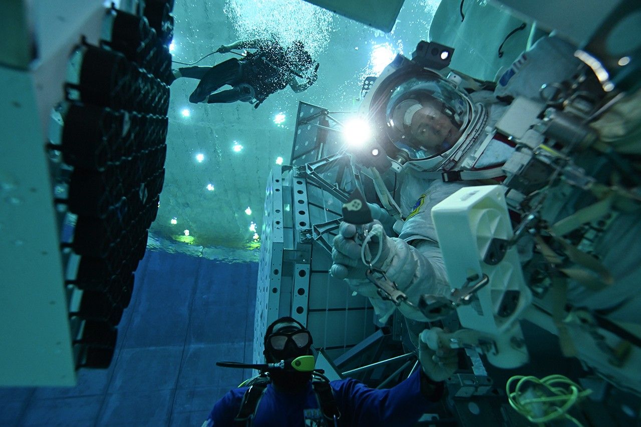
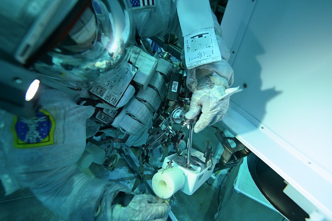
NASA astronaut Nick Hague will install patches to the agency’s NICER (Neutron star Interior Composition Explorer) X-ray telescope on the International Space Station as part of a spacewalk scheduled for Jan. 16. Hague, along with astronaut Suni Williams, will also complete other tasks during the outing.
NICER will be the first NASA observatory repaired on-orbit since the last servicing mission for the Hubble Space Telescope in 2009.
Hague and other astronauts, including Don Pettit, who is also currently on the space station, rehearsed the NICER patch procedures in the NBL (Neutral Buoyancy Laboratory), a 6.2-million-gallon indoor pool at NASA’s Johnson Space Center in Houston, in 2024.
NASA astronaut Nick Hague holds a patch for NICER (Neutron star Interior Composition Explorer) at the end of a T-handle tool during a training exercise on May 16, 2024, in the NBL (Neutral Buoyancy Laboratory) at NASA’s Johnson Space Center in Houston.
NASA/NBL Dive Team
Astronaut Nick Hague removes a patch from the caddy using a T-handle tool during a training exercise in the NBL at NASA Johnson on May 16, 2024. The booklet on his wrist has a schematic of the NICER telescope and where the patches will go.
NASA/NBL Dive Team
“We use the NBL to mimic, as much as possible, the conditions astronauts will experience while preforming a task during a spacewalk,” said Lucas Widner, a flight controller at KBR and NASA Johnson who ran the NICER NBL sessions. “Most projects outside the station focus on maintenance and upgrades to components like solar panels. It’s been exciting for all of us to be part of getting a science mission back to normal operations.”
From its perch near the space station’s starboard solar array, NICER studies the X-ray sky, including erupting galaxies, black holes, superdense stellar remnants called neutron stars, and even comets in our solar system.
But in May 2023, NICER developed a “light leak.” Sunlight began entering the telescope through several small, damaged areas in the telescope’s thin thermal shields. During the station’s daytime, the light reaches the X-ray detectors, saturating sensors and interfering with NICER’s measurements of cosmic objects. The mission team altered their daytime observing strategy to mitigate the effect.
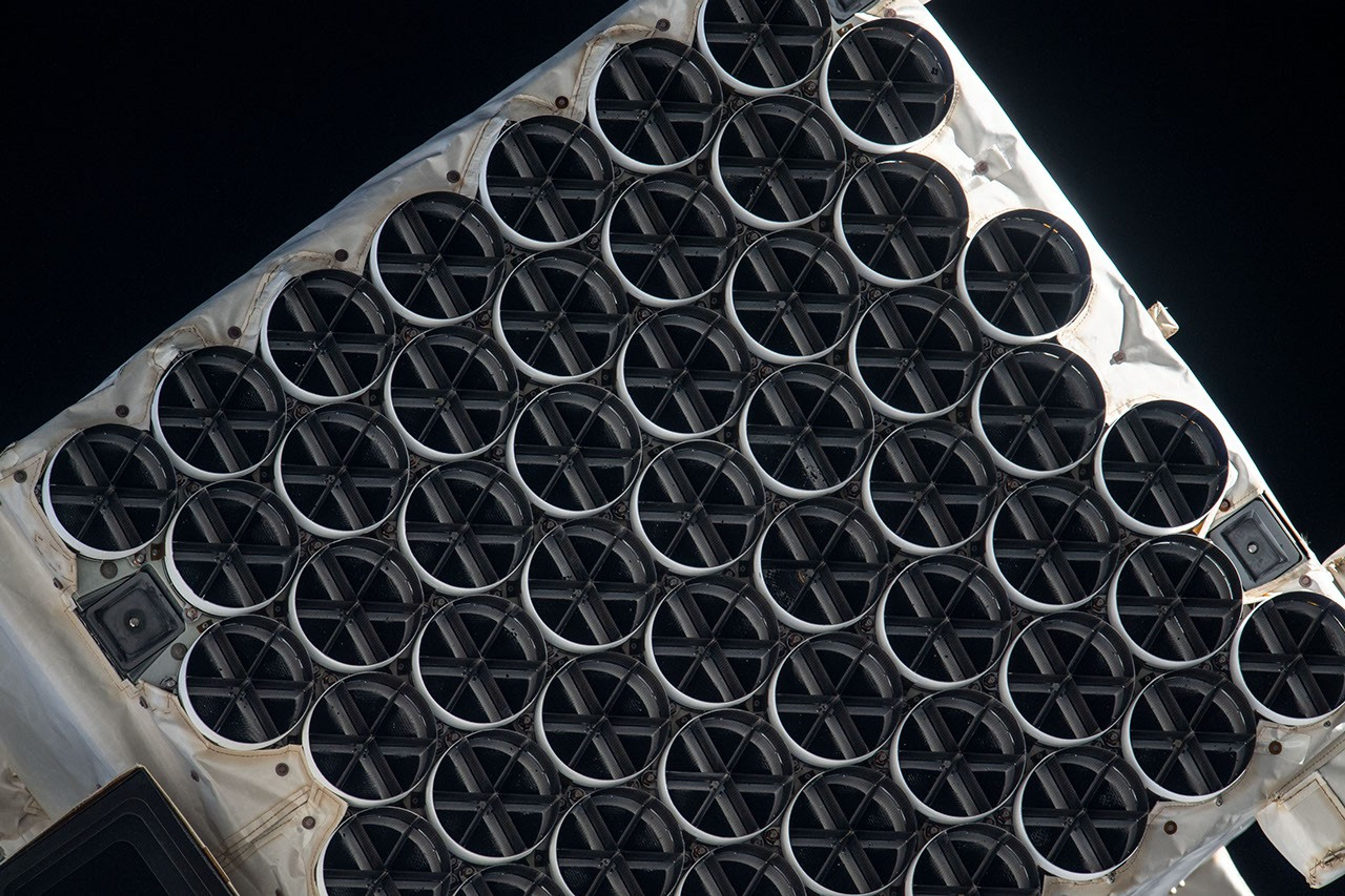
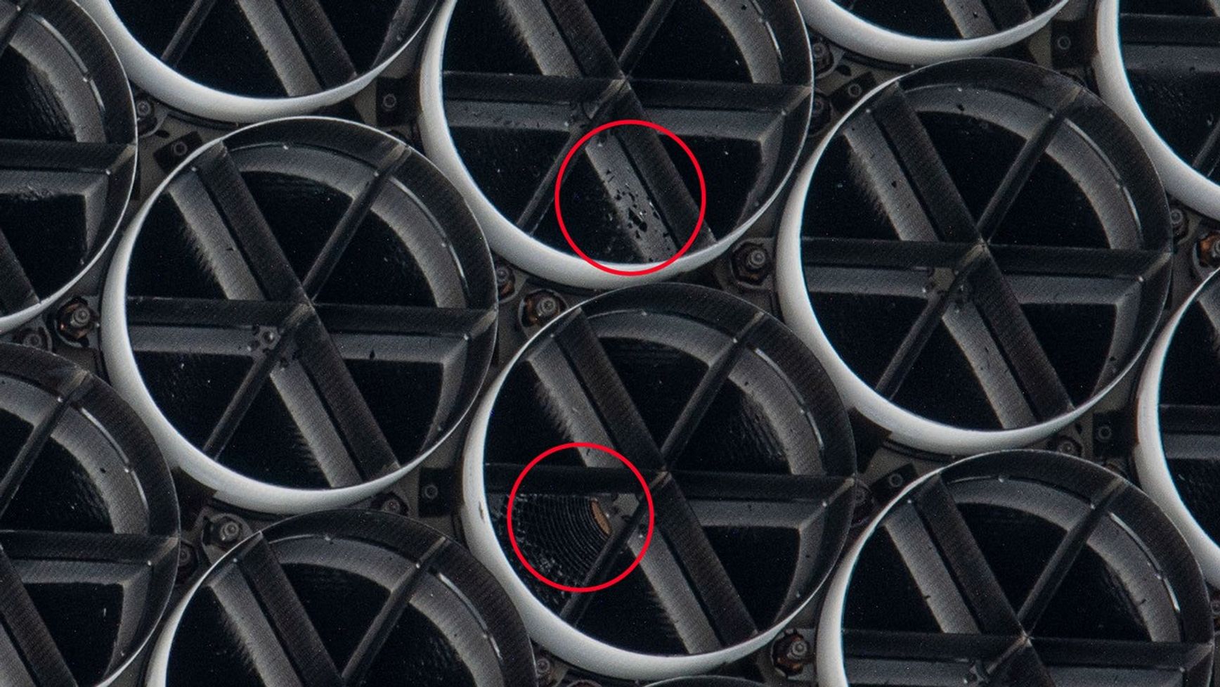
UAE (United Arab Emirates) astronaut Sultan Alneyadi captured this view of NICER from a window in the space station’s Poisk Mini-Research Module 2 in July 2023. Photos like this one helped the NICER team map the damage to the telescope’s thermal shields.
NASA/Sultan Alneyadi
Some of NICER’s damaged thermal shields (circled) are visible in this photograph.
NASA/Sultan Alneyadi
The team also developed a plan to cover the largest areas of damage using wedge-shaped patches. Hague will slide the patches into the telescope’s sunshades and lock them into place.
“We designed the patches so they could be installed either robotically or by an astronaut,” said Steve Kenyon, NICER’s mechanical engineering lead at NASA’s Goddard Space Flight Center in Greenbelt, Maryland. “They’re installed using a tool called a T-handle that the astronauts are already familiar with.”
The NBL contains life-size mockups of sections of the space station. Under the supervision of a swarm of scuba divers, a pair of astronauts rehearse exiting and returning through an airlock, traversing the outside of the station, and completing tasks.
For the NICER repair, the NBL team created a full-scale model of NICER and its surroundings near the starboard solar array. Hague, Pettit, and other astronauts practiced taking the patches out of their caddy, inserting them into the sunshades, locking them into place, and verifying they were secure.
The task took just under an hour each time, which included the time astronauts needed to travel to NICER, set up their tools, survey the telescope for previously undetected damage, complete the repair, and clean up their tools.
Practice runs also provided opportunities for the astronauts to troubleshoot how to position themselves so they could reach NICER without touching it too often and for flight controllers to identify safety concerns around the repair.
Astronaut Don Pettit simulates taking pictures of the NICER telescope mockup during a training exercise in the NBL at NASA Johnson on May 16, 2024.
NASA/NBL Dive Team
Astronaut Don Pettit removes a patch from the caddy during a training exercise in the NBL at NASA Johnson on May 16, 2024.
NASA/NBL Dive Team
Being fully submerged in a pool is not the same as being in space, of course, so some issues that arose were “pool-isms.” For example, astronauts sometimes drifted upward while preparing to install the patches in a way unlikely to happen in space.
Members of the NICER team, including Kenyon and the mission’s principal investigator, Keith Gendreau at NASA Goddard, supported the NBL practice runs. They helped answer questions about the physical aspects of the telescope, as well as science questions from the astronauts and flight controllers. NICER is the leading source of science results on the space station.
“It was awesome to watch the training sessions and be able to debrief with the astronauts afterward,” Gendreau said. “There isn’t usually a lot of crossover between astrophysics science missions and human spaceflight. NICER will be the first X-ray telescope serviced by astronauts. It’s been an exciting experience, and we’re all looking forward to the spacewalk where it will all come together.”
The NICER telescope is an Astrophysics Mission of Opportunity within NASA’s Explorers Program, which provides frequent flight opportunities for world-class scientific investigations from space utilizing innovative, streamlined, and efficient management approaches within the heliophysics and astrophysics science areas. NASA’s Space Technology Mission Directorate supported the SEXTANT component of the mission, demonstrating pulsar-based spacecraft navigation.
NASA’s 2024 AI Use Case inventory highlights the agency’s commitment to integrating artificial intelligence in its space missions and operations. The agency’s updated inventory consists of active AI use cases, ranging from AI-driven autonomous space operations, such as navigation for the Perseverance Rover on Mars, to advanced data analysis for scientific discovery.
AI Across NASA
NASA’s use of AI is diverse and spans several key areas of its missions:
Autonomous Exploration and Navigation
AEGIS (Autonomous Exploration for Gathering Increased Science): AI-powered system designed to autonomously collect scientific data during planetary exploration.
Enhanced AutoNav for Perseverance Rover: Utilizes advanced autonomous navigation for Mars exploration, enabling real-time decision-making.
MLNav (Machine Learning Navigation): AI-driven navigation tools to enhance movement across challenging terrains.
Perseverance Rover on Mars – Terrain Relative Navigation: AI technology supporting the rover’s navigation across Mars, improving accuracy in unfamiliar terrain.
Mission Planning and Management
ASPEN Mission Planner: AI-assisted tool that helps streamline space mission planning and scheduling, optimizing mission efficiency.
AWARE (Autonomous Waiting Room Evaluation): AI system that manages operational delays, improving mission scheduling and resource allocation.
CLASP (Coverage Planning & Scheduling): AI tools for resource allocation and scheduling, ensuring mission activities are executed seamlessly.
Onboard Planner for Mars2020 Rover: AI system that helps the Perseverance Rover autonomously plan and schedule its tasks during its mission.
Environmental Monitoring and Analysis
SensorWeb for Environmental Monitoring: AI-powered system used to monitor environmental factors such as volcanoes, floods, and wildfires on Earth and beyond.
Volcano SensorWeb: Similar to SensorWeb, but specifically focused on volcanic activity, leveraging AI to enhance monitoring efforts.
Global, Seasonal Mars Frost Maps: AI-generated maps to study seasonal variations in Mars’ atmosphere and surface conditions.
Data Management and Automation
NASA OCIO STI Concept Tagging Service: AI tools that organize and tag NASA’s scientific data, making it easier to access and analyze.
Purchase Card Management System (PCMS): AI-assisted system for streamlining NASA’s procurement processes and improving financial operations.
Aerospace and Air Traffic Control
NextGen Methods for Air Traffic Control: AI tools to optimize air traffic control systems, enhancing efficiency and reducing operational costs.
NextGen Data Analytics: Letters of Agreement: AI-driven analysis of agreements within air traffic control systems, improving management and operational decision-making.
Space Exploration
Mars2020 Rover (Perseverance): AI systems embedded within the Perseverance Rover to support its mission to explore Mars.
SPOC (Soil Property and Object Classification): AI-based classification system used to analyze soil and environmental features, particularly for Mars exploration.
Ethical AI: NASA’s Responsible Approach
NASA ensures that all AI applications adhere to Responsible AI (RAI) principles outlined by the White House in its Executive Order 13960. This includes ensuring AI systems are transparent, accountable, and ethical. The agency integrates these principles into every phase of development and deployment, ensuring AI technologies used in space exploration are both safe and effective.
Looking Forward: AI’s Expanding Role
As AI technologies evolve, NASA’s portfolio of AI use cases will continue to grow. With cutting-edge tools currently in development, the agency is poised to further integrate AI into more aspects of space exploration, from deep space missions to sustainable solutions for planetary exploration.
By maintaining a strong commitment to both technological innovation and ethical responsibility, NASA is not only advancing space exploration but also setting an industry standard for the responsible use of artificial intelligence in scientific and space-related endeavors.
2023 Entrepreneurs Challenge Winner Skyline Nav AI: Revolutionizing GPS-Independent Navigation with Computer Vision
NASA sponsored Entrepreneurs Challenge events in 2020, 2021, and 2023 to identify innovative ideas and technologies from small business start-ups with the potential to advance the agency’s science goals. To help leverage external funding sources for the development of innovative technologies of interest to NASA, SMD involved the venture capital community in Entrepreneurs Challenge events. Challenge winners were awarded prize money, and in 2023 the total Entrepreneurs Challenge prize value was $1M. Numerous challenge winners have subsequently received funding from both NASA and external sources (e.g., other government agencies or the venture capital community) to further develop their technologies.
Skyline Nav AI, a winner of the 2023 NASA Entrepreneurs Challenge, is pioneering GPS-independent navigation by leveraging cutting-edge computer vision models, artificial intelligence (AI), and edge computing.
Skyline Nav AI’s flagship technology offers precise, real-time geolocation without the need for GPS, Wi-Fi, or cellular networks. The system utilizes machine learning algorithms to analyze terrain and skyline features and match them with preloaded reference datasets, providing up to centimeter-level accuracy in GPS-denied environments. This capability could enable operations in areas where GPS signals are absent, blocked, degraded, spoofed, or jammed, including urban canyons, mountainous regions, and the Moon.
Skyline Nav AI’s flagship technology at work in New York to provide precise location by matching the detected skyline with a reference data set. The red line shows detection by Skyline Nav AI technology, the green line marks the true location in the reference satellite dataset, and the orange line represents the matched location (i.e., the location extracted from the satellite dataset using Skyline Nav AI algorithms).
Skyline Nav’s visual navigation technology can deliver accuracy up to five meters, 95% of the time. The AI-powered visual positioning models continuously improve geolocation precision through pixel-level analysis and semantic segmentation of real-time images, offering high reliability without the need for GPS.
In addition to its visual-based AI, Skyline Nav AI’s software is optimized for edge computing, ensuring that all processing occurs locally on the user’s device. This design enables low-latency, real-time decision-making without constant satellite or cloud-based connectivity, making it ideal for disconnected environments such as combat zones or space missions.
Furthermore, Skyline Nav AI’s technology can be integrated with various sensors, including inertial measurement units (IMUs), lidar, and radar, to further enhance positioning accuracy. The combination of visual navigation and sensor fusion can enable centimeter-level accuracy, making the technology potentially useful for autonomous vehicles, drones, and robotics operating in environments where GPS is unreliable.
“Skyline Nav AI aims to provide the world with an accurate, resilient alternative to GPS,” says Kanwar Singh, CEO of Skyline Nav AI. “Our technology empowers users to navigate confidently in even the most challenging environments, and our recent recognition by NASA and other partners demonstrates the value of our innovative approach to autonomous navigation.”
Skyline Nav AI continues to expand its influence through partnerships with organizations such as NASA, the U.S. Department of Defense, and the commercial market. Recent collaborations include projects with MIT, Draper Labs, and AFRL (Air Force Research Laboratory), as well as winning the MOVE America 2024 Pitch competition and being a finalist in SXSW 2024.
Sponsoring Organization: The NASA Science Mission Directorate sponsored the Entrepreneurs Challenge events.
Project Leads: Kanwar Singh, Founder & CEO of Skyline Nav AI
Preparations for Next Moonwalk Simulations Underway (and Underwater)
Danah Tommalieh, commercial pilot and engineer at Reliable Robotics, inputs a flight plan at the control center in Mountain View, California, ahead of remotely operating a Cessna 208 aircraft at Hollister municipal airport in Hollister, California.
NASA/Don Richey
NASA recently began a series of flight tests with partners to answer an important aviation question: What will it take to integrate remotely piloted or autonomous planes carrying large packages and cargo safely into the U.S. airspace? Researchers tested new technologies in Hollister, California, that are helping to investigate what tools and capabilities are needed to make these kinds of flights routine.
The commercial industry continues to make advancements in autonomous aircraft systems aimed at making it possible for remotely operated aircraft to fly over communities – transforming the way we will transport people and goods. As the Federal Aviation Administration (FAA) develops standards for this new type of air transportation, NASA is working to ensure these uncrewed flights are safe by creating the required technological tools and infrastructure. These solutions could be scaled to support many different remotely piloted aircraft – including air taxis and package delivery drones – in a shared airspace with traditional crewed aircraft.
“Remotely piloted aircraft systems could eventually deliver cargo and people to rural areas with limited access to commercial transportation and delivery services,” said Shivanjli Sharma, aerospace engineer at NASA’s Ames Research Center in California’s Silicon Valley. “We’re aiming to create a healthy ecosystem of many different kinds of remotely piloted operations. They will fly in a shared airspace to provide communities with better access to goods and services, like medical supply deliveries and more efficient transportation.”
During a flight test in November, Reliable Robotics, a company developing an autonomous flight system, remotely flew its Cessna 208 Caravan aircraft through pre-approved flight paths in Hollister, California.
Although a safety pilot was aboard, a Reliable Robotics remote pilot directed the flight from their control center in Mountain View, more than 50 miles away.
Cockpit of Reliable Robotics’ Cessna 208 aircraft outfitted with autonomous technology for remotely-piloted operations.
NASA/Brandon Torres Navarrete
Congressional staffers from the United States House and Senate’s California delegation joined NASA Deputy Associate Administrator for Aeronautics Research Mission Directorate, Carol Caroll, Ames Aeronautics Director, Huy Tran, and other Ames leadership at Reliable Robotics Headquarters to view the live remote flight.
Researchers evaluated a Collins Aerospace ground-based surveillance system’s ability to detect nearby air traffic and provide the remote pilot with information in order to stay safely separated from other aircraft in the future.
Initial analysis shows the ground-based radar actively surveilled the airspace during the aircraft’s taxi, takeoff, and landing. The data was transmitted from the radar system to the remote pilot at Reliable Robotics. In the future, this capability could help ensure aircraft remain safely separated across all phases of fight.
A Reliable Robotics’ modified Cessna 208 aircraft flies near Hollister Airport. A Reliable Robotics pilot operated the aircraft remotely from the control center in Mountain View.
NASA/Brandon Torres Naverrete
While current FAA operating rules require pilots to physically see and avoid other aircraft from inside the cockpit, routine remotely piloted aircraft will require a suite of integrated technologies to avoid hazards and coordinate with other aircraft in the airspace.
A radar system for ground-based surveillance offers one method for detecting other traffic in the airspace and at the airport, providing one part of the capability to ensure pilots can avoid collision and accomplish their desired missions. Data analysis from this testing will help researchers understand if ground-based surveillance radar can be used to satisfy FAA safety rules for remotely piloted flights.
NASA will provide analysis and reports of this flight test to the FAA and standards bodies.
“This is an exciting time for the remotely piloted aviation community,” Sharma said. “Among other benefits, remote operations could provide better access to healthcare, bolster natural disaster response efforts, and offer more sustainable and effective transportation to both rural and urban communities. We’re thrilled to provide valuable data to the industry and the FAA to help make remote operations a reality in the near future.”
Over the next year, NASA will work with additional aviation partners on test flights and simulations to test weather services, communications systems, and other autonomous capabilities for remotely piloted flights. NASA researchers will analyze data from these tests to provide a comprehensive report to the FAA and the community on what minimum technologies and capabilities are needed to enable and scale remotely piloted operations.
Small Business Innovation Research (SBIR) and Small Business Technology Transfer (STTR)
The SBIR/STTR programs provide an opportunity for small, high technology companies and research institutions (RI) to participate in Government sponsored research and development (R&D) efforts in key technology areas. NASA SBIR Phase I contracts have a period of performance for 6 months with a maximum funding of $125,000, and Phase II contracts have a period of performance up to 24 months with a maximum funding of $750,000. The STTR Phase I contracts last for 13 months with a maximum funding of $125,000, and Phase II contracts last for 24 months with the maximum contract value of $750,000.
This website uses cookies to improve your experience. We'll assume you're ok with this, but you can opt-out if you wish.AcceptRead More
Privacy & Cookies Policy
Privacy Overview
This website uses cookies to improve your experience while you navigate through the website. Out of these, the cookies that are categorized as necessary are stored on your browser as they are essential for the working of basic functionalities of the website. We also use third-party cookies that help us analyze and understand how you use this website. These cookies will be stored in your browser only with your consent. You also have the option to opt-out of these cookies. But opting out of some of these cookies may affect your browsing experience.
Necessary cookies are absolutely essential for the website to function properly. This category only includes cookies that ensures basic functionalities and security features of the website. These cookies do not store any personal information.
Any cookies that may not be particularly necessary for the website to function and is used specifically to collect user personal data via analytics, ads, other embedded contents are termed as non-necessary cookies. It is mandatory to procure user consent prior to running these cookies on your website.