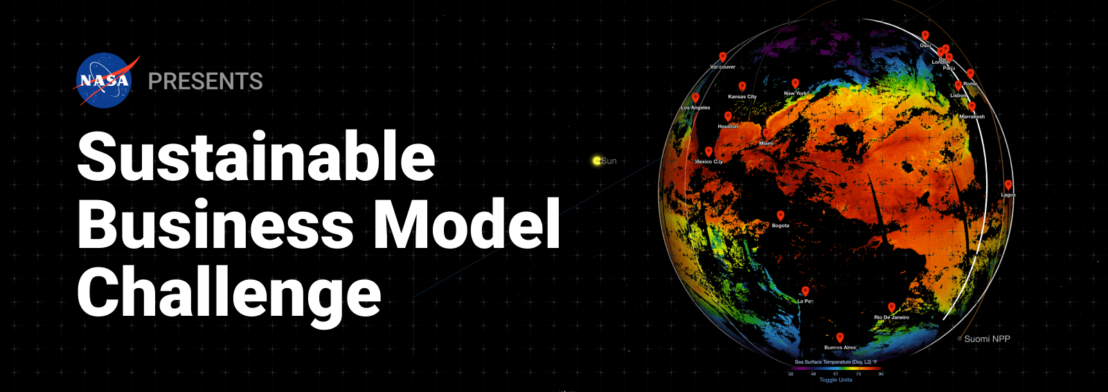
NASA’s Sustainable Business Model Challenge is looking for entrepreneurs, startups, and researchers to leverage the agency’s publicly available Earth system science data to develop commercial solutions for climate challenges.
This opportunity, with a submission deadline of June 13, bridges the gap between vast climate data and actionable solutions by inviting solvers to transform data into sustainable business models that support climate resilience and decision-making.
“Creative, outcome-driven entrepreneurs are the lifeblood of our country’s economy, and we’re excited to see the sustainable climate solutions they’re able to come up with when working closely with NASA’s vast resources and data,” said Jason L. Kessler, program executive for the NASA Small Business Innovation Research / Small Business Technology Transfer (SBIR/STTR) program, which is sponsoring the challenge.
Through the Sustainable Business Model Challenge, NASA aims to foster a new set of sustainable enterprises capable of turning climate insights into tangible market-ready services, ultimately contributing to a more resilient future for vulnerable communities, businesses, and ecosystems. NASA is committed to broadening participation in its solicitations and fostering technology advancements.
By engaging new entrepreneurs, the challenge serves as a pathway to NASA’s SBIR/STTR program, helping scale solutions to advance the global response to climate change and encourage a more sustainable future. From its vantage point in space, NASA holds a wealth of data that can inform new approaches to climate adaptation and mitigation.
Participants will submit a 10-page business concept paper that includes details on how they will incorporate NASA climate or Earth system data to deliver a product or service. Up to ten winning teams will receive $10,000 each, along with admission to a 10-week capability development training designed to strengthen any future proposals for potential NASA funding.
NASA’s SBIR/STTR program, managed by the agency’s Space Technology Mission Directorate, is part of America’s Seed Fund, the nation’s largest source of early-stage funding for innovative technologies. Through this program, entrepreneurs, startups, and small businesses with less than 500 employees can receive funding and non-monetary support to build, mature, and commercialize their technologies, advancing NASA missions and advancing the nations aerospace economy.
Trailer for NASA’s upcoming documentary, “Planetary Defenders,” which will take audiences inside the high-stakes world of asteroid hunting and planetary defense.
NASA is bringing the high-stakes world of planetary defense to the Sundance Film Festival, highlighting its upcoming documentary, “Planetary Defenders,” during a panel ahead of its spring 2025 premiere on the agency’s streaming service.
“We’re thrilled that NASA is attending Sundance Film Festival for the first time – a festival renowned for its innovative spirit,” said Brittany Brown, director, NASA Office of Communications Digital and Technology Division, at the agency’s Headquarters in Washington. “Our participation represents a groundbreaking opportunity for NASA to engage with the film industry and share new avenues for collaborative storytelling. By connecting with the creative minds at the festival, we aim to inspire new narratives, explore new avenues for collaborative storytelling, and ignite a renewed sense of wonder in space exploration.”
The NASA+ film explores a compelling question: How would humanity respond if we discovered an asteroid headed for Earth? Far from science fiction, “Planetary Defenders” follows real-life astronomers and other experts as they navigate the challenges of asteroid detection and safeguarding our planet from potential hazards.
“NASA is home to some of the greatest stories ever told, and NASA’s new streaming platform NASA+ is dedicated to sharing these stories to inspire the next generation,” said Rebecca Sirmons, general manager and head of NASA+. “We are honored to host a panel at this year’s Sundance Film Festival discussing our upcoming NASA+ documentary “Planetary Defenders.”
The panel, entitled “You Bet Your Asteroid: NASA Has a Story to Tell,” will start at 1:30 p.m. MST on Sunday, Jan. 26, at the Filmmaker Lodge in the Elks Building, 550 Main St., 2nd Floor, Park City, Utah. The event will include a discussion about the film followed by a Q&A session. Attendees also will have the opportunity to meet NASA experts and some of the planetary defenders themselves.
Panelists include:
Rebecca Sirmons, head of NASA+, NASA
Scott Bednar, filmmaker and director, NASA 360/National Institute of Aerospace
Jessie Wilde, filmmaker and director, NASA 360/National Institute of Aerospace
Dr. Kelly Fast, acting planetary defense officer, NASA’s Planetary Defense Coordination Office
David Rankin, senior survey operations specialist, Catalina Sky Survey
Dr. Vishnu Reddy, professor of planetary sciences and director of the Space4 Center, University of Arizona
Media are encouraged to RSVP in advance and may request one-on-one interviews with NASA experts following the panel by contacting Karen Fox at karen.c.fox@nasa.gov.
Through NASA+, the agency is continuing its decades long tradition of sharing live events, original content, and the latest news while NASA works to improve life on Earth through innovation, exploration, and discovery for the benefit of all. The free, on-demand streaming service is available to download without a subscription on most major platforms via the NASA App on iOS and Android mobile and tablet devices, as well as streaming media players like Roku, Apple TV, and Fire TV.
To keep up with the latest news from NASA’s planetary defense program, visit:
Preparations for Next Moonwalk Simulations Underway (and Underwater)
2025 Seminar Series
Throughout 2025, the NASA History Office is presenting a seminar series on the topic of Aerospace Latin America. This series will explore the origins, evolution, and historical context of aerospace in the region since the dawn of the Space Age, touching on a broad range of topics including aerospace infrastructure development, space policy and law, Earth science applications, and much more.
This seminar series is part of a collaborative effort to gather insights and research that will conclude in an anthology of essays to be published as a NASA History Special Publication. Individual presentations will be held virtually bi-weekly or monthly.
During a gravity assist in 1992, the Galileo spacecraft took images of Earth and the Moon. Separate images were combined to generate this composite which features a view of the Pacific Ocean and Central and South America.
NASA/JPL/USGS
Upcoming Presentations
“Governing the Moon: A History”
Stephen Buono (University of Chicago)
Thursday, February 6 at 1pm CST
In this talk, Stephen Buono will provide a nuanced history of the unratified Agreement Governing the Activities of States on the Moon and Other Celestial Bodies, more commonly known as the Moon Treaty. Buono will illuminate the treaty’s deep origins, the contributions of international space lawyers, the details of the negotiating process, the role played by the United States in shaping the final text, and the contributions of the treaty’s single most important author, Argentine lawyer, Aldo Armando Cocca.
“A God’s Eye View: Aviators and the Re-Conquest of Latin America”
Pete Soland(University of Houston—Downtown)
Thursday, February 20 at 1pm CST
This talk scrutinizes the aviator-conquistador metaphor. It examines airplane pilots as personifying high modernism and the technological sublime in Latin America from the turn of the century through the early Space Age, when spaceships and astronauts eclipsed airplanes and aviators. Repeated invocations of the conquistador as a metaphor for the aviator’s social role–and the conquest as an analogy for the goals of aviation programs–illustrate how elites promoted their modernization initiatives to national publics.
How to Attend
These presentations will be held via Microsoft Teams. For details on how to attend the meetings, join the NASA History mailing list to receive updates. Just send a blank email to history-join@lists.hq.nasa.gov to join. Alternatively, send us an email to receive a link for the next meeting.
NASA International Space Apps Challenge Announces 2024 Global Winners
The 2024 NASA Space Apps Challenge was hosted at 485 events in 163 countries and territories.
Credits: NASA
NASA Space Apps has named 10 global winners, recognizing teams from around the world for their exceptional innovation and collaboration during the 2024 NASA Space Apps Challenge. As the largest annual global hackathon, this event invites participants to leverage open data from NASA and its space agency partners to tackle real-world challenges on Earth and in space.
Last year’s hackathon welcomed 93,520 registered participants, including space, science, technology, and storytelling enthusiasts of all ages. Participants gathered at local events in 163 countries and territories, forming teams to address the challenges authored by NASA subject matter experts. These challenges included subjects/themes/questions in ocean ecosystems, exoplanet exploration, Earth observation, planetary seismology, and more.
The 2024 Global Winners were determined out of 9,996 project submissions and judged by subject matter experts from NASA and space agency partners.
“These 10 exceptional teams created projects that reflect our commitment to understanding our planet and exploring beyond, with the potential to transform Earth and space science for the benefit of all,” said Dr. Keith Gaddis, NASA Space Apps Challenge program scientistat NASA Headquarters in Washington. “The NASA Space Apps Challenge showcases the potential of every idea and individual. I am excited to see how these innovators will shape and inspire the future of science and exploration.”
You can watch the Global Winners Announcement here to meet these winning teams and learn about the inspiration behind their projects.
2024 NASA Space Apps Challenge Global Winners
Best Use of Science Award: WMPGang
Team Members: Dakota C., Ian C., Maximilian V., Simon S.
Challenge: Create an Orrery Web App that Displays Near-Earth Objects
Country/Territory: Waterloo,Canada
Using their skills in programming, data analysis, and visualization, WMPGang created a web app that identifies satellite risk zones using real-time data on Near-Earth Objects and meteor streams.
Team Members: Aakash H., Arun G., Arthur A., Gabriel A., May K.
Challenge: Leveraging Earth Observation Data for Informed Agricultural Decision-Making
Country/Territory: Universal Event, United States
GaamaRamma’s team of tech enthusiasts aimed to create a sustainable way to help farmers efficiently manage water availability in the face of drought, pests, and disease.
Team Members: Alailton A., Ana B., Gabriel C., Gustavo M., Gustavo T., Larissa M.
Challenge: Seismic Detection Across the Solar System
Country/Territory: Maceió, Brazil
Team 42 QuakeHeroes employed a deep neural network model to identify the precise locations of seismic events within time-series data. They used advanced signal processing techniques to isolate and analyze unique components of non-stationary signals.
Team Members: Oksana M., Oleksandra M., Prokipchyn Y., Val K.
Challenge: Leveraging Earth Observation Data for Informed Agricultural Decision-Making
Country/Territory: Kyiv, Ukraine
The NVS-knot team assessed planting conditions using surface soil moisture and evapotranspiration data, then created an app that empowers farmers to manage planting risks.
Team Members: Coral M., Daniel C., Daniel V., Juan B., Samuel G., Vladimir C.
Challenge: Landsat Reflectance Data: On the Fly and at Your Fingertips
Country/Territory: Gijón, Spain
AsturExplorers created Landsat Connect, a web app that provides a simple, intuitive way to track Landast satellites and access Landsat surface reflectance data. The app also allows users to set a target location and receive notifications when Landsat satellites pass over their area.
Team Members: Rikzah K., Samira K., Shafeeqa J., Umamah A.
Challenge: SDGs in the Classroom
Country/Territory: Sharjah, United Arab Emirates
Innovisionaries developed Eco-Metropolis to inspire sustainability through gameplay. This city-building game engages players in making critical urban planning and resource management decisions based on real-world environmental data.
Team Members: Ahmed R., Fatma E., Habiba A., Judy A., Maya M.
Challenge: Tell Us a Climate Story!
Country/Territory: Cairo, Egypt
TerraTales shared stories of how Earth’s changing climate affects three unique regions: Egypt, Brazil, and Germany. The web app also features an artificial intelligence (AI) model for climate forecasting and an interactive game to encourage users to make eco-friendly choices.
Team Members: Kapeesh K., Khoi N., Sathyajit L., Satyam S.
Challenge: Navigator for the Habitable Worlds Observatory (HWO): Mapping the Characterizable Exoplanets in our Galaxy
Country/Territory: Saskatoon, Canada
Team Asteroid Destroyer honed in on exoplanets, utilizing data processing and machine learning techniques to map exoplanets based on size, temperature, and distance.
Team Members: Gabriel M., Luc R., Lucas R., Mattheus L., Pedro C., Riccardo S.
Challenge: Imagine our Connected Earth
Country/Territory: Campinas, Brazil
Team Connected Earth Museum created an immersive virtual museum experience to raise awareness of Earth’s changing climate. An AI host guides users through an interactive gallery featuring 3D and 2D visualizations, including a time series on Earth and ocean temperatures, population density, wildfires, and more.
Team Members: Frank R., Jan K., Raphael R., Ryan Z., Victoria M.
Challenge: Community Mapping
Country/Territory: Florianópolis, Brazil
Team I.O. bridges the gap between complex Geographic Information Systems data and user-friendly communication, making critical environmental information accessible to everyone, regardless of technical expertise.
Want to take part in the 2025 NASA Space Apps Challenge? Mark your calendars for October 4 and 5! Registration will open in July. At that time, participants will be able to register for a local event hosted by NASA Space Apps leads from around the world. You can stay connected with NASA Space Apps on Facebook, Instagram, and X.
Elton W. Miller, chief of aerodynamics at what is now NASA’s Langley Research Center in Hampton, Virginia, stands in the entrance cone of the Propeller Research Tunnel in this Sept. 9, 1926, photo. In front of the entrance is the Sperry M-1 Messenger, the first full-scale airplane tested in the tunnel.
The Propeller Research Tunnel, or PRT as it came to be known, was only the National Advisory Committee for Aeronautics’ third wind tunnel and the largest one built. The PRT was in fact the largest tunnel built at that time anywhere in the world. Designed to accommodate a full-scale propeller, the throat of the PRT was 20 feet in diameter.
On Dec. 19, 2024, NASA released two amendments to the NASA Research Announcement Research Opportunities in Space and Earth Sciences (ROSES) 2024 (NNH24ZDA001N) to announce the E.9 Space Biology: Research Studies and E.12 Physical Sciences Research Studies program elements.
For Precision Health-focused studies, investigators may propose to use any non-primate animal model system and any appropriate cell/tissue culture/microphysiological system/organoid or microbial models that are supported by the chosen platform.
For Space Crop-focused studies, applicants may propose to use any plant, relevant microbe, and/or plant and microbe model system(s) that is (are) supported by the chosen platform.
The E.9 Space Biology: Research Studies opportunity includes five different Project Types: Research Investigations, Early Career Research Investigations, New NASA Investigators, OSDR Analytical Investigations, and Tissue Sharing Investigations. Specific requirements for each of these Project Types are described in the program element text. Questions concerning E.9 Space Biology: Research Studies may be directed to Lynn Harrison (for Precision Health) and Elison Blancaflor (for Space Crops) at nasa-spacebiology@mail.nasa.gov.
Physical Sciences Proposals
E.12 Physical Sciences: Research Studies solicits proposals to investigate physical phenomena in the absence of gravity and fundamental laws that describe the universe, and applied research that contributes to the basic understanding of processes underlying space exploration technologies.
The Physical Sciences program is divided into two key goals: Foundations and Quantum Leaps. Foundations focuses on understanding the behavior of fluids, combustion, soft matter, and materials in the spaceflight environment. Quantum Leaps aims to probe the very nature of the universe using exquisitely precise space-based quantum sensors to test the Einstein equivalence principle, dark sector physics, and the nature of fundamental physical constants.
The E.12 Physical Sciences: Research Studies opportunity will include four different Project Types: Research Investigations, New NASA Investigators, Physical Sciences Informatics, and Fundamental Physics Investigations. Specific requirements for each of these Project Types are described in detail in the program element text. Questions concerning E.12 Physical Sciences Research Studies may be directed to Brad Carpenter (regarding Foundations and PSI) or Mike Robinson (regarding Quantum Leaps) by writing to BPS-PhysicalSciences@nasaprs.com.
Town Hall
A pre-proposer’s townhall for applicants interested in submitting a proposal to these program elements will be held virtually on Jan. 22, 2025, at 3 p.m. Eastern Time. Meeting information will be posted on the NSPIRES page for each of the program elements under “Other Documents.”
Proposals to these program elements shall be submitted via a two-step process
Step-1 proposals must be submitted by Feb. 4, 2025
An adult Alamosaurus sports eclipse glasses outside of The Children’s Museum of Indianapolis, on April 6, 2024. Two days later, the total solar eclipse swept across a narrow portion of the North American continent from Mexico’s Pacific coast to the Atlantic coast of Newfoundland, Canada. A partial solar eclipse was visible across the entire North American continent along with parts of Central America and Europe.
Firefly Aerospace’s Blue Ghost lander getting encapsulated in SpaceX’s rocket fairing ahead of the planned liftoff for 1:11 a.m. EST Jan. 15 from Launch Complex 39A at NASA’s Kennedy Space Center in Florida
SpaceX
As part of NASA’s CLPS (Commercial Lunar Payload Services) initiative and Artemis campaign, the agency is preparing to fly ten instruments aboard Firefly Aerospace’s first delivery to the Moon. These science payloads and technology demonstrations will help advance our understanding of the Moon and planetary processes, while paving the way for future crewed missions on the Moon and beyond, for the benefit of all.
Firefly’s lunar lander, named Blue Ghost, is scheduled to launch on a SpaceX Falcon 9 rocket Wednesday, Jan.15, from Launch Complex 39A at NASA’s Kennedy Space Center in Florida. After a 45-day cruise phase, Blue Ghost is targeted to land near a volcanic feature called Mons Latreille within Mare Crisium, a basin approximately 340 miles wide (550 kilometers) located in the northeast quadrant of the Moon’s near side.
How can we enable more precise navigation on the Moon? How do spacecraft interact with the lunar surface? How does Earth’s magnetic field influence the effects of space weather on our home planet? NASA’s instruments on this flight will conduct first-of-their-kind demonstrations to help answer these questions and more, including testing regolith sampling technologies, lunar subsurface drilling capabilities, increasing precision of positioning and navigation abilities, testing radiation tolerant computing, and learning how to mitigate lunar dust during lunar landings.
The ten NASA payloads aboard Firefly’s Blue Ghost lander include:
Lunar Instrumentation for Subsurface Thermal Exploration with Rapidity (LISTER)will measure heat flow from the Moon’s interior by measuring the thermal gradient, or changes in temperature at various depths, and thermal conductivity, or the subsurface material’s ability to let heat pass through it. LISTER will take several measurements up to 10 feet deep using pneumatic drilling technology with a custom heat flow needle instrument at its tip. Data from LISTER will help scientists retrace the Moon’s thermal history and understand how it formed and cooled. Lead organization: Texas Tech University
Lunar PlanetVac (LPV)is designed to collect regolith samples from the lunar surface using a burst of compressed gas to drive the regolith into a sample chamber (sieving) for collection and analysis by various instruments. Additional instrumentation will then transmit the results back to Earth. The LPV payload is designed to help increase the science return from planetary missions by testing low-cost technologies for collecting regolith samples in-situ. Lead organization: Honeybee Robotics
Next Generation Lunar Retroreflector (NGLR)serves as a target for lasers on Earth to precisely measure the distance between Earth and the Moon by reflecting very short laser pulses from Earth-based Lunar Laser Ranging Observatories. The laser pulse transit time to the Moon and back is used to determine the distance. Data from NGLR could improve the accuracy of our lunar coordinate system and contribute to our understanding of the inner structure of the Moon and fundamental physics questions. Lead organization: University of Maryland
Regolith Adherence Characterization (RAC)will determine how lunar regolith sticks to a range of materials exposed to the Moon’s environment throughout the lunar day. RAC will measure accumulation rates of lunar regolith on surfaces (for example, solar cells, optical systems, coatings, and sensors) through imaging to determine their ability to repel or shed lunar dust. The data captured will help test, improve, and protect spacecraft, spacesuits, and habitats from abrasive regolith. Lead organization: Aegis Aerospace
Radiation Tolerant Computer (RadPC)will demonstrate a computer that can recover from faults caused by ionizing radiation. Several RadPC prototypes have been tested aboard the International Space Station and Earth-orbiting satellites, but this flight will provide the biggest trial yet by demonstrating the computer’s ability to withstand space radiation as it passes through Earth’s radiation belts, while in transit to the Moon, and on the lunar surface. Lead organization: Montana State University
Electrodynamic Dust Shield (EDS)is an active dust mitigation technology that uses electric fields to move and prevent hazardous lunar dust accumulation on surfaces. EDS is designed to lift, transport, and remove particles from surfaces with no moving parts. Multiple tests will demonstrate the feasibility of the self-cleaning glasses and thermal radiator surfaces on the Moon. In the event the surfaces do not receive dust during landing, EDS has the capability to re-dust itself using the same technology. Lead organization: NASA’s Kennedy Space Center
Lunar Environment heliospheric X-ray Imager (LEXI)will capture a series of X-ray images to study the interaction of solar wind and Earth’s magnetic field that drives geomagnetic disturbances and storms. Deployed and operated on the lunar surface, this instrument will provide the first global images showing the edge of Earth’s magnetic field for critical insights into how space weather and other cosmic forces surrounding our planet impact Earth. Lead organizations: Boston University, NASA’s Goddard Space Flight Center, and Johns Hopkins University
Lunar Magnetotelluric Sounder (LMS)will characterize the structure and composition of the Moon’s mantle by measuring electric and magnetic fields. This investigation will help determine the Moon’s temperature structure and thermal evolution to understand how the Moon has cooled and chemically differentiated since it formed. Lead organization: Southwest Research Institute
Lunar GNSS Receiver Experiment (LuGRE)will demonstrate the possibility of acquiring and tracking signals from GNSS (Global Navigation Satellite System) constellations, specifically GPS and Galileo, during transit to the Moon, during lunar orbit, and on the lunar surface. If successful, LuGRE will be the first pathfinder for future lunar spacecraft to use existing Earth-based navigation constellations to autonomously and accurately estimate their position, velocity, and time. Lead organizations: NASA Goddard, Italian Space Agency
Stereo Camera for Lunar Plume-Surface Studies (SCALPSS)will use stereo imaging photogrammetry to capture the impact of the rocket exhaust plume on lunar regolith as the lander descends on the Moon’s surface. The high-resolution stereo images will aid in creating models to predict lunar regolith erosion, which is an important task as bigger, heavier spacecraft and hardware are delivered to the Moon in close proximity to each other. This instrument also flew on Intuitive Machines’ first CLPS delivery. Lead organization: NASA’s Langley Research Center
Through the CLPS initiative, NASA purchases lunar landing and surface operations services from American companies. The agency uses CLPS to send scientific instruments and technology demonstrations to advance capabilities for science, exploration, or commercial development of the Moon. By supporting a robust cadence of lunar deliveries, NASA will continue to enable a growing lunar economy while leveraging the entrepreneurial innovation of the commercial space industry.
Measurements from space support wildfire risk predictions
Researchers demonstrated that data from the International Space Station’s ECOsystem Spaceborne Thermal Radiometer Experiment on Space Station (ECOSTRESS) instrument played a significant role in the ability of machine learning algorithms to predict wildfire susceptibility. This result could help support development of effective strategies for predicting, preventing, monitoring, and managing wildfires.
As the frequency and severity of wildfires increases worldwide, experts need reliable models of fire susceptibility to protect public safety and support natural resource planning and risk management. ECOSTRESS measures evapotranspiration, water use efficiency, and other plant-water dynamics on Earth. Researchers report that its water use efficiency data consistently emerged as the leading factor in predicting wildfires, with evaporative stress and topographic slope data also significant.
This ECOsystem Spaceborne Thermal Radiometer Experiment on Space Station evapotranspiration image of California’s Central Valley in May 2022 shows high water use (blue) and dry conditions (brown).
NASA
Combining instruments provides better emissions data
Scientists found that averaging data from the International Space Station’s OCO‐3 and EMIT external instruments can accurately measure the rate of carbon dioxide emissions from power plants. This work could improve emissions monitoring and help communities respond to climate change.
Carbon dioxide emissions from fossil fuel combustion make up nearly a third of human-caused emissions and are a major contributor to climate change. In many places, though, scientists do not know exactly how much carbon dioxide these sources emit. The Orbiting Carbon Observatory-3 or OCO-3 can quantify emissions over large areas and Earth Surface Mineral Dust Source Investigation data can help determine emissions from individual facilities. The researchers suggest future work continue to investigate the effect of wind conditions on measurements.
The The Orbiting Carbon Observatory-3 data showing carbon dioxide concentrations in Los Angeles.
NASA
Thunderstorm phenomena observed from space
Observations by the International Space Station’s Atmosphere-Space Interactions Monitor (ASIM) instrument during a tropical cyclone in 2019 provide insight into the formation and nature of blue corona discharges often observed at the tops of thunderclouds. A better understanding of such processes in Earth’s upper atmosphere could improve atmospheric models and weather and climate predictions.
Scientists do not fully understand the conditions that lead to formation of blue corona discharges, bursts of electrical streamers, which are precursors to lightning. Observations from the ground are affected by scattering and absorption in the clouds. ASIM, a facility from ESA (European Space Agency), provides a unique opportunity for observing these high-atmosphere events from space.
View of Atmosphere-Space Interactions Monitor, the white and blue box on the end of the International Space Station’s Columbus External Payload Facility.
NASA’s SPHEREx observatory will use a technique called spectroscopy across the entire sky, capturing the universe in more than 100 colors.
Credit: BAE Systems
Media accreditation is open for the launch of two NASA missions that will explore the mysteries of our universe and Sun.
The agency is targeting late February to launch its SPHEREx (Spectro-Photometer for the History of the Universe, Epoch of Reionization and Ices Explorer) observatory, a space telescope that will create a 3D map of the entire sky to help scientists investigate the origins of our universe. NASA’s PUNCH (Polarimeter to Unify the Corona and Heliosphere) mission, which will study origins of the Sun’s outflow of material, or the solar wind, also will ride to space with the telescope.
NASA and SpaceX will launch the missions aboard the company’s Falcon 9 rocket from Space Launch Complex 4E at Vandenberg Space Force Base in California.
Accredited media will have the opportunity to participate in a series of prelaunch briefings and interviews with key mission personnel, including a science briefing the week of launch. NASA will communicate additional details regarding the media event schedule as the launch date approaches.
Media interested in covering the launch must apply for media accreditation. The application deadline for U.S. citizens is 11:59 p.m. EST, Thursday, Feb. 6, while international media without U.S. citizenship must apply by 11:59 p.m., Monday, Jan. 20.
NASA’s media accreditation policy is available online. For questions about accreditation, please email: ksc-media-accreditat@mail.nasa.gov. For other mission questions, please contact the newsroom at NASA’s Kennedy Space Center in Florida at 321-867-2468.
Para obtener información sobre cobertura en español en el Centro Espacial Kennedy o si desea solicitar entrevistas en español, comuníquese con Antonia Jaramillo: 321-501-8425, o Messod Bendayan: 256-930-1371.
Updates about spacecraft launch preparations are available on the agency’s SPHEREx blog and PUNCH blog.
The SPHEREx mission will observe hundreds of millions of stars and galaxies in infrared light, a range of wavelengths not visible to the human eye. With this map, SPHEREx will enable scientists to study inflation, or the rapid expansion of the universe a fraction of a second after the big bang. The observatory also will measure the collective glow from galaxies near and far, including light from hidden galaxies that individually haven’t been observed, and look for reservoirs of water, carbon dioxide, and other key ingredients for life in our home galaxy.
Launching as a rideshare with SPHEREx, the agency’s PUNCH mission is made up of four suitcase-sized satellites that will spread out around Earth’s day-night line to observe the Sun and space with a combined field of view. Working together, the four satellites will map out the region where the Sun’s outer atmosphere, the corona, transitions to the solar wind, or the constant outflow of material from the Sun.
The SPHEREx observatory is managed by NASA’s Jet Propulsion Laboratory in Southern California for the Astrophysics Division within the agency’s Science Mission Directorate in Washington. The mission principal investigator is based jointly at NASA JPL and Caltech. Formerly Ball Aerospace, BAE Systems built the telescope, supplied the spacecraft bus, and performed observatory integration. The science analysis of the SPHEREx data will be conducted by a team of scientists located at 10 institutions in the U.S., two in South Korea, and one in Taiwan. Data will be processed and archived at IPAC at Caltech. The SPHEREx data set will be publicly available.
The agency’s PUNCH mission is led by Southwest Research Institute’s office in Boulder, Colorado. The mission is managed by the Explorers Program Office at NASA’s Goddard Space Flight Center in Greenbelt, Maryland, for NASA’s Science Mission Directorate. NASA’s Launch Services Program, based at NASA Kennedy, manages the launch service for the SPHEREx and PUNCH missions.
For more details about the SPHEREx mission and updates on launch preparations, visit:
But we’re not stopping to rest on our laurels. In 2024, NASA selected 25 new citizen science proposals for funding that will lead to new projects and new results to look forward to in 2025 and beyond. Here’s a roundup of those selections and the principal investigators (PIs) of each team—a sneak peek at what’s coming next in NASA citizen science! Note that these investigations are research grants–some of them will result in new opportunities for the public, others will use results from earlier citizen science projects or develop new tools.
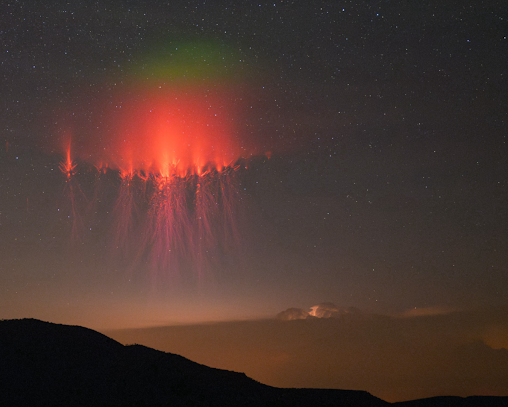
Bright green glow observed from Texas on June 1, 2024, by Stephen Hummel. A new grant to the Spritacular project team will support citizen science research on this newly-discovered phenomenon.
Stephen Hummel
Citizen Science Seed Funding Program (CSSFP)
The CSSFP aims to support scientists and other experts to develop citizen science projects and to expand the pool of scientists who use citizen science techniques in their science investigations. Four divisions of NASA’s Science Mission Directorate are participating in the CSSFP: the Astrophysics Division, the Biological and Physical Sciences Division, the Heliophysics Division, and the Planetary Science Division. Nine new investigations were recently selected through this program:
Astrophysics Division
SuPerPiG Observing Grid, PI RachelHuchmala, Boise State University. Use a small telescope to monitor exoplanets to improve our knowledge of their orbits.
Understanding the Nature of Clumpy Galaxies with Clump-Scout 2: a New Citizen-Science Project to Characterize Star-Forming Clumps in Nearby Galaxies. PI Claudia Scarlata, University of Minnesota. Label clumps of distant galaxies to help us understand Hubble Space Telescope data.
‘Backyard Worlds: Binaries’ — Discovering Benchmark Brown Dwarfs Through Citizen Science. PI Aaron Meisner, NSF’s NOIRLab. Search for planet-like objects called brown dwarfs that orbit nearby stars.
Mobile Toolkits to Enable Transient Follow-up Observations by Amateur Astronomers. PI Michael Coughlin, University of Minnesota. Use your own telescope to observe supernovae, kilonovae and other massive explosions.
Planetary Science Division
A Citizen Scientist Approach to High Resolution Geologic Mapping of Intracrater Impact Melt Deposits as an input to Numerical Models, PI Kirby Runyon, Planetary Science Institute. Help map lunar craters so we can better understand how meteor impacts sculpt the moon’s surface.
Identifying Active Asteroids in Public Datasets, PI Chad Trujillo, Northern Arizona University, Search for icy, comet-like bodies hiding in the asteroid belt using new data from the Canada-France-Hawaii telescope.
Heliophysics Division
Enabling Magnetopause Observations With Informal Researchers (EMPOWR). PI Mo Wenil, Johns Hopkins University. Investigate plasma layers high above the Earth using data from NASA’s Magnetospheric Multiscale (MMS) mission and the Zooniverse platform.
High-resolution Ionospheric Imaging using Dual-Frequency Smartphones. PI Josh Semeter, Boston University. Study the upper atmosphere using cell phone signals.
Large Scale Structures Originating from the Sun (LASSOS) multi-point catalog: A citizen project connecting operations to research. PI Cecelia Mac Cormack, Catholic University of America. Help build a catalog of structures on the Sun.
Comet Identification and Image Annotation Modernization for the Sungrazer Citizen Science Project. PI Oliver Gerland. Search for comets in data from ESA and NASA’s Solar and Heliospheric Observatory (SOHO) mission using new web tools.
The HCSI program supports medium-scale citizen science projects in the Heliophysics Division of NASA’s Science Mission Directorate. Six investigations were recently selected through this program:
Investigation of green afterglow observed above sprite and gigantic jet tops based on Spritacular project database, PI Burcu Kosar. Photograph electric phenomena above storm clouds to help us understand a newly discovered green glow and learn about atmospheric chemistry.
Machine Learning competition for Solar Wind prediction in preparation of solar maximum. PI Enrico Camporeale, University of Colorado, Boulder. Take part in a competition to predict the speed of the solar wind using machine learning.
A HamSCI investigation of the bottomside ionosphere during the 2023 annular and 2024 total solar eclipses. PI Gareth Perry, New Jersey Institute of Technology. Use Ham Radio data to investigate the effects of solar eclipses on the ionosphere.
Dynamic footprint in mid-latitude mesospheric clouds. PI Chihiko Cullens, University of Colorado, Boulder. Collect and analyze data on noctilucent clouds, rare high-altitude clouds that shine at night.
Monitoring Solar Activity During Solar Cycle 25 with the GAVRT Solar Patrol Science and Education Program. PI Marin Anderson, Jet Propulsion Laboratory. Track solar activity during the period leading up to and including solar maximum.
What is the total energy input to the heliosphere from solar jets? PI Nour Rawafi, The Johns Hopkins University Applied Physics Laboratory. Identify solar jets in images from the Solar Dynamics Observatory
Citizen Science for Earth Systems Program (CSESP)
CSESP opportunities focus on developing and implementing projects that harness contributions from members of the general public to advance our understanding of Earth as a system. Proposals for the 2024 request were required to demonstrate a clear link between citizen science and NASA observation systems to advance the agency’s Earth science mission. Nine projects received funding.
Engaging Citizen Scientists for Inclusive Earth Systems Monitoring, PI Duan Biggs, Northern Arizona University. Measure trees in tropical regions south of the equator with the GLOBE Observer App to improve models of vegetation structure and biomass models from NASA’s Global Ecosystem Dynamics Investigation (GEDI) mission.
Integrating Remote Sensing and Citizen Science to Support Conservation of Woodland Vernal Pools, PI Laura Bourgeau-Chavez, Michigan Technological University. Map and monitor shallow, seasonal wetlands in Michigan, Wisconsin and New York to better understand these key habitats of amphibians and other invertebrates.
Citizen-Enabled Measurement of PM2.5 and Black Carbon: Addressing Local Inequities and Validating PM Composition from MAIA, Albert Presto/Carnegie Mellon University. Deploy sensors to measure sources of fine airborne particle pollution filling gaps in data from NASA’s Multi-Angle Imager for Aerosols (MAIA) mission.
Expanding Citizen Science Hail Observations for Validation of NASA Satellite Algorithms and Understanding of Hail Melt, PI Russ Schumacher, Colorado State University. Measure the sizes and shapes of hailstones, starting in the southeastern United States, using photographs and special pads to help us understand microwave satellite data.
X-Snow: A Citizen-Science Proposal for Snow in the New York Area, PI, Marco Tedesco, Columbia University. Measure snow in the Catskill and Adirondacks regions of New York to help improve NASA’s models of snow depth and water content.
Coupling Citizen Science and Remote Sensing Observations to Assess the Impacts of Icebergs on Coastal Arctic Ecosystems, PI, Maria Vernet, University of California, San Diego. Measure phytoplankton samples in polar regions to understand how icebergs and their meltwater affect phytoplankton concentration and biodiversity.
Forecasting Mosquito-Borne Disease Risk in a Changing Climate: Integrating GLOBE Citizen Science and NASA Earth System Modeling, PI Di Yang, University of Florida, Gainesville. Using data on mosquitoes from the GLOBE Observer App to predict future changes in mosquito-borne disease risk.
Ozone Measurements from General Aviation: Supporting TEMPO Satellite Validation and Addressing Air Quality Issues in California’s San Joaquin Valley with Citizen Science, PI Emma Yates, NASA Ames Research Center. Deploy air-quality sensors around Bakersfield, California and compare the data to measurements from NASA’s Tropospheric Emissions Monitoring of Pollution instrument (TEMPO).
Under the Canopy: Capturing the Role of Understory Phenology on Animal Communities Using Citizen Science, PI Benjamin Zuckerberg, University of Wisconsin, Madison. Measure snow depth, temperature, and sound in forest understories to improve satellite-based models of vegetation and snow cover for better modeling of wildlife communities.
For more information on citizen science awards from previous years, see articles from:
NASA and Italian Space Agency Test Future Lunar Navigation Technology
The potentially record-breaking Lunar GNSS Receiver Experiment (LuGRE) payload will be the first known demonstration of GNSS signal reception on and around the lunar surface.
Credits: NASA/Dave Ryan
As the Artemis campaign leads humanity to the Moon and eventually Mars, NASA is refining its state-of-the-art navigation and positioning technologies to guide a new era of lunar exploration.
A technology demonstration helping pave the way for these developments is the Lunar GNSS Receiver Experiment (LuGRE) payload, a joint effort between NASA and the Italian Space Agency to demonstrate the viability of using existing GNSS (Global Navigation Satellite System) signals for positioning, navigation, and timing on the Moon.
During its voyage on an upcoming delivery to the Moon as part of NASA’s CLPS (Commercial Lunar Payload Services) initiative, LuGRE would demonstrate acquiring and tracking signals from both the U.S. GPS and European Union Galileo GNSS constellations during transit to the Moon, during lunar orbit, and finally for up to two weeks on the lunar surface itself.
The Lunar GNSS Receiver Experiment (LuGRE) will investigate whether signals from two Global Navigation Satellite System (GNSS) constellations, the U.S. Global Positioning System (GPS) and European Union’s Galileo, can be tracked at the Moon and used for positioning, navigation, and timing (PNT).
The LuGRE payload is one of the first demonstrations of GNSS signal reception and navigation on and around the lunar surface, an important milestone for how lunar missions will access navigation and positioning technology. If successful, LuGRE would demonstrate that spacecraft can use signals from existing GNSS satellites at lunar distances, reducing their reliance on ground-based stations on the Earth for lunar navigation.
Today, GNSS constellations support essential services like navigation, banking, power grid synchronization, cellular networks, and telecommunications. Near-Earth space missions use these signals in flight to determine critical operational information like location, velocity, and time.
NASA and the Italian Space Agency want to expand the boundaries of GNSS use cases. In 2019, the Magnetospheric Multiscale (MMS) mission broke the world record for farthest GPS signal acquisition 116,300 miles from the Earth’s surface — nearly half of the 238,900 miles between Earth and the Moon. Now, LuGRE could double that distance.
“GPS makes our lives safer and more viable here on Earth,” said Kevin Coggins, NASA deputy associate administrator and SCaN (Space Communications and Navigation) Program manager at NASA Headquarters in Washington. “As we seek to extend humanity beyond our home planet, LuGRE should confirm that this extraordinary technology can do the same for us on the Moon.”
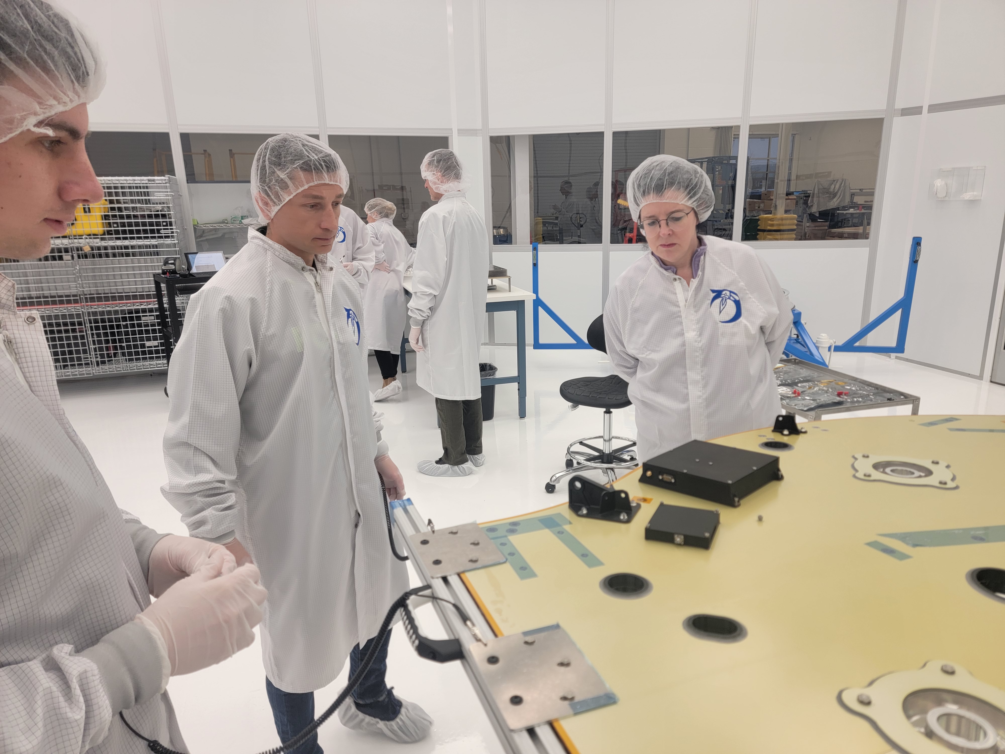
NASA, Firefly, Qascom, and Italian Space Agency team members examine LuGRE hardware in a clean room.
Firefly Aerospace
Reliable space communication and navigation systems play a vital role in all NASA missions, providing crucial connections from space to Earth for crewed and uncrewed missions alike. Using a blend of government and commercial assets, NASA’s Near Space and Deep Space Networks support science, technology demonstrations, and human spaceflight missions across the solar system.
“This mission is more than a technological milestone,” said Joel Parker, policy lead for positioning, navigation, and timing at NASA’s Goddard Space Flight Center in Greenbelt, Maryland. “We want to enable more and better missions to the Moon for the benefit of everyone, and we want to do it together with our international partners.”
This mission is more than a technological milestone. We want to enable more and better missions to the Moon for the benefit of everyone…
JOEL PARKER
PNT Policy Lead at NASA’s Goddard Space Flight Center
The data-gathering LuGRE payload combines NASA-led systems engineering and mission management with receiver software and hardware developed by the Italian Space Agency and their industry partner Qascom — the first Italian-built hardware to operate on the lunar surface.
Any data LuGRE collects is intended to open the door for use of GNSS to all lunar missions, not just those by NASA or the Italian Space Agency. Approximately six months after LuGRE completes its operations, the agencies will release its mission data to broaden public and commercial access to lunar GNSS research.
Firefly Aerospace’s Blue Ghost Mission One lander is carrying 10 NASA science and technology instruments to the Moon as part of NASA’s CLPS (Commercial Lunar Payload Services) initiative and Artemis campaign.
Firefly Aerospace
“A project like LuGRE isn’t about NASA alone,” said NASA Goddard navigation and mission design engineer Lauren Konitzer. “It’s something we’re doing for the benefit of humanity. We’re working to prove that lunar GNSS can work, and we’re sharing our discoveries with the world.”
The LuGRE payload is one of 10 NASA-funded science experiments launching to the lunar surface on this delivery through NASA’s CLPS initiative. Through CLPS, NASA works with American companies to provide delivery and quantity contracts for commercial deliveries to further lunar exploration and the development of a sustainable lunar economy. As of 2024, the agency has 14 private partners on contract for current and future CLPS missions.
Demonstrations like LuGRE could lay the groundwork for GNSS-based navigation systems on the lunar surface. Bridging these existing systems with emerging lunar-specific navigation solutions has the potential to define how all spacecraft navigate lunar terrain in the Artemis era.
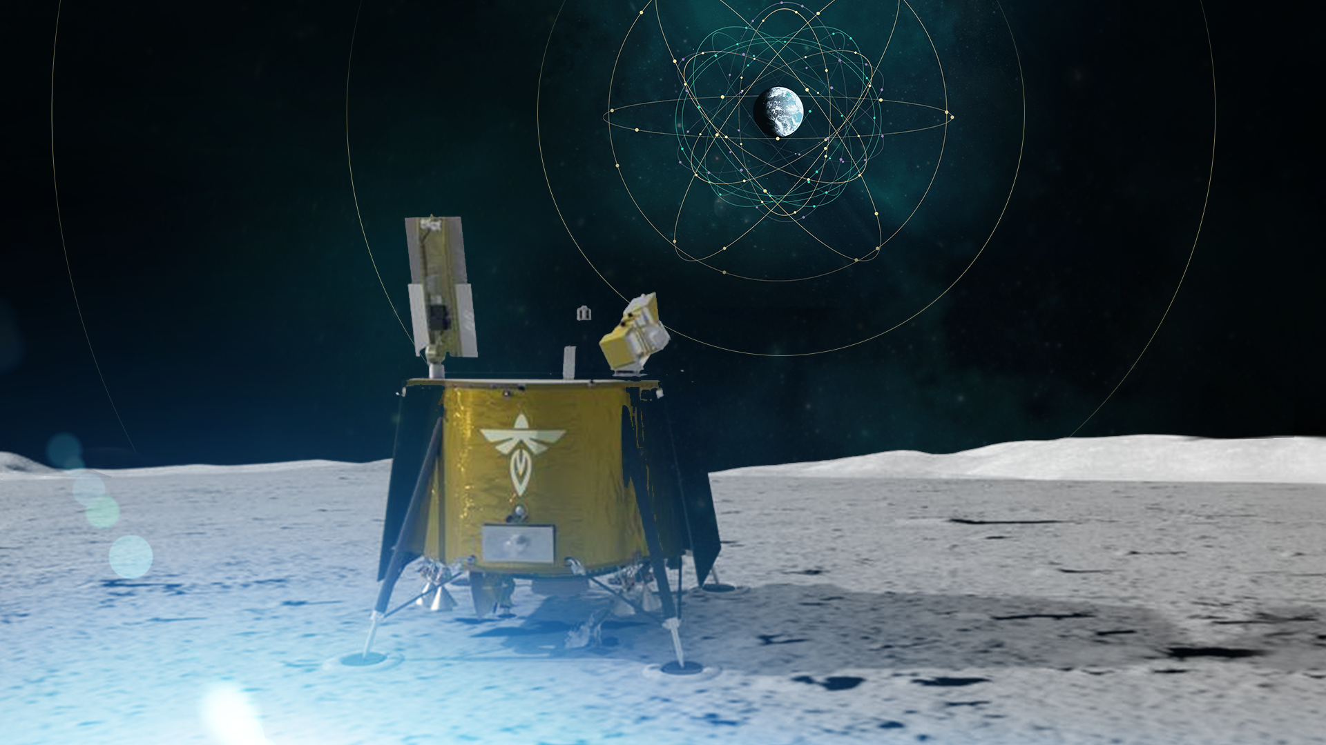
Artist’s concept rendering of LuGRE aboard the Blue Ghost lunar lander receiving signals from Earth’s GNSS constellations.
NASA/Dave Ryan
The payload is a collaborative effort between NASA’s Goddard Space Flight Center and the Italian Space Agency. Funding and oversight for the LuGRE payload comes from the agency’s SCaN Program office. It was chosen by NASA as one of 10 funded research and technology demonstrations for delivery to the lunar surface by Firefly Aerospace Inc, a flight under the agency’s CLPS initiative.
About the Author
Korine Powers
Senior Writer and Education Lead
Korine Powers, Ph.D. is a writer for NASA’s Space Communications and Navigation (SCaN) program office and covers emerging technologies, commercialization efforts, education and outreach, exploration activities, and more.
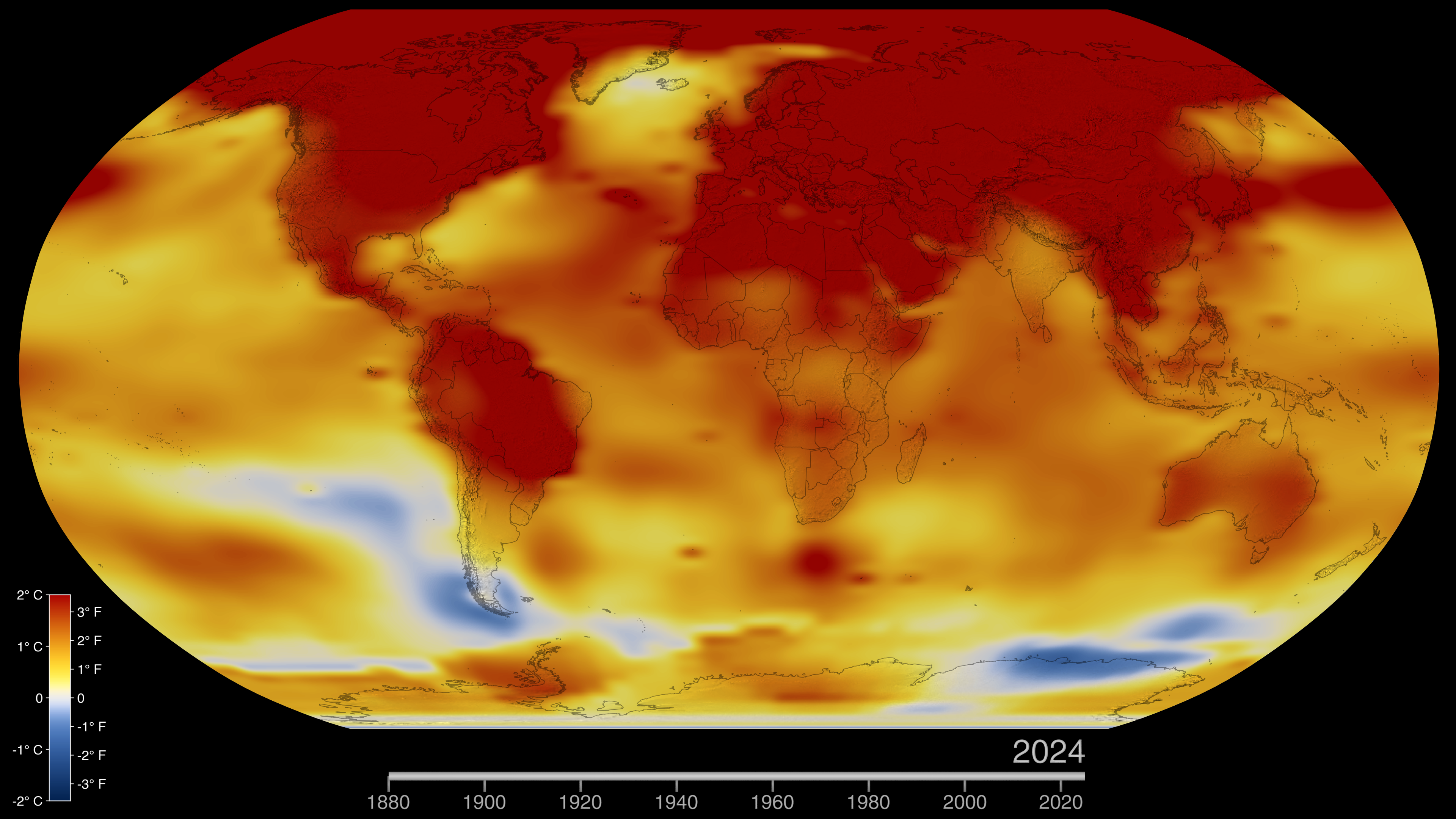
Este mapa de la Tierra en 2024 muestra las anomalías de la temperatura global de la superficie, es decir, cuánto más caliente o más fría estuvo cada región del planeta en comparación con el promedio de 1951 a 1980. Las temperaturas normales se muestran en blanco, las superiores a las normales en rojo y naranja, y las inferiores a las normales en azul. Una versión animada de este mapa muestra la evolución de las anomalías de la temperatura global a lo largo del tiempo, desde 1880. Descarga esta visualización del Estudio de Visualización Científica del Centro Goddard de la NASA: https://svs.gsfc.nasa.gov/5450.
Crédito: Estudio de Visualización Científica de la NASA
En el año 2024, la temperatura promedio de la superficie de la Tierra fue la más cálida que se haya registrado, según un análisis liderado por científicos de la NASA.
“Una vez más, se ha batido el récord de temperatura: 2024 fue el año más cálido desde que se empezaron a llevar registros en 1880”, dijo el administrador de la NASA, Bill Nelson. “Entre las temperaturas récord y los incendios forestales que amenazan actualmente nuestros centros y personal en California, nunca ha sido más importante entender nuestro planeta cambiante”.
Las temperaturas globales del 2024 estuvieron 2,30 grados Fahrenheit (1,28 grados Celsius) por encima del promedio para el período de referencia de la NASA (de 1951 a 1980), superando el récord establecido en 2023. El nuevo máximo histórico llega después de 15 meses consecutivos (junio de 2023 a agosto de 2024) de récords de temperaturas mensuales, una racha de calor sin precedentes.
Científicos de la NASA también estiman que en el 2024 la Tierra estuvo alrededor de 2,65 grados Fahrenheit (1,47 grados Celsius) más cálida que el promedio de mediados del siglo XIX (1850-1900). Durante más de la mitad del 2024, las temperaturas promedio superaron en 1,5 grados Celsius el nivel de referencia, y el promedio anual, con incertidumbres matemáticas, podría haber superado el nivel por primera vez.
“El Acuerdo de París sobre el cambio climático establece esfuerzos para mantenerse por debajo del nivel de 1,5 grados a largo plazo. Para poner eso en perspectiva, las temperaturas durante los períodos cálidos en la Tierra hace tres millones de años —cuando el nivel del mar era decenas de metros más alto que hoy— eran solo unos 3 grados Celsius más cálidos que los niveles preindustriales”, dijo Gavin Schmidt, director del Instituto Goddard de Investigaciones Espaciales (GISS, por sus siglas en inglés) de la NASA en Nueva York. “Estamos a medio camino de alcanzar niveles de calor del Plioceno en apenas 150 años”.
El 2024 fue el año más cálido de la Tierra desde que comenzaron los registros modernos alrededor de 1880, y los últimos 10 años consecutivos han sido los 10 más cálidos jamás registrados. Crédito: NASA/Grace Weikert/Glori Wills
Los científicos han concluido que la tendencia al calentamiento de las últimas décadas está siendo impulsada por el dióxido de carbono, el metano y otros gases de efecto invernadero que atrapan el calor. Según un análisis internacional reciente, en 2022 y 2023 la Tierra registró un aumento récord de las emisiones de dióxido de carbono procedentes de combustibles fósiles. La concentración de dióxido de carbono en la atmósfera ha aumentado desde los niveles preindustriales en el siglo XVIII de aproximadamente 278 partes por millón a alrededor de 420 partes por millón en la actualidad.
La NASA y otras agencias federales recopilan regularmente datos sobre las concentraciones y emisiones de gases de efecto invernadero. Estos datos están disponibles en el Centro de Gases de Efecto Invernadero de Estados Unidos, una iniciativa de múltiples instituciones que consolida la información procedente de observaciones y modelos, con el fin de ofrecer a los responsables de la toma de decisiones un único punto de acceso a datos y análisis.
Tendencias de calor excepcional
Las temperaturas de cada año pueden verse influidas por fluctuaciones climáticas naturales como El Niño y La Niña, que alternativamente calientan y enfrían el océano Pacífico tropical. El fuerte fenómeno de El Niño que comenzó en el otoño boreal de 2023 contribuyó a que las temperaturas mundiales superaran los récords anteriores.
Esta visualización de datos, que se actualiza mensualmente, muestra las anomalías mensuales de la temperatura global en la superficie de la Tierra, y cómo esas temperaturas se desvían del promedio entre 1951 y 1980. Descarga esta visualización en español del Estudio de Visualización Científica del Centro Goddard de la NASA: https://svs.gsfc.nasa.gov/5190 Crédito: Estudio de Visualización Científica de la NASA
La ola de calor que comenzó en 2023 siguió superando las expectativas en 2024, según Schmidt, a pesar de que El Niño remitió. Los investigadores están trabajando en la identificación de los factores que contribuyen a este fenómeno, incluidos los posibles efectos climáticos de la erupción volcánica de Tonga de enero de 2022 y de las reducciones de la contaminación, que pueden cambiar la cubierta de nubes y la forma en que la energía solar se refleja hacia el espacio.
“No en todos los años se van a batir récords, pero la tendencia a largo plazo es clara”, dijo Schmidt. “Ya estamos viendo el impacto en las precipitaciones extremas, las olas de calor y el aumento del riesgo de inundaciones, que van a seguir empeorando mientras continúen las emisiones”.
Cambios a nivel local
La NASA elabora su registro de temperaturas a partir de los datos de temperatura del aire en superficie recolectados por decenas de miles de estaciones meteorológicas, así como de los datos de temperatura de la superficie del mar adquiridos por instrumentos en barcos y boyas. Para el análisis de estos datos, se emplean métodos que toman en consideración el espaciamiento variado de las estaciones de temperatura a nivel global y los efectos del calentamiento urbano que podrían sesgar los cálculos.
Una nueva evaluación publicada a principios de este año por científicos de la Escuela de Minas de Colorado, la Fundación Nacional para las Ciencias, la Administración Nacional Oceánica y Atmosférica (NOAA, por sus siglas en inglés) y la NASA provee aún más confianza en los datos de temperatura global y regional de la agencia.
“Cuando se producen cambios en el clima, primero se ven en la media mundial, luego se ven a nivel continental y después a nivel regional. Ahora lo estamos viendo a nivel local”, dijo Schmidt. “Los cambios que se están produciendo en las experiencias meteorológicas cotidianas de la gente se han hecho muy evidentes”.
Los análisis independientes de la NOAA, Berkeley Earth, el Centro Hadley (parte de la Oficina Meteorológica del Reino Unido, Met Office) y el Servicio de Cambio Climático de Copernicus en Europa también han concluido que las temperaturas de la superficie global para 2024 fueron las más altas desde que comenzaron los registros modernos. Estos científicos utilizan gran parte de los mismos datos de temperatura en sus análisis, pero emplean metodologías y modelos diferentes. Todos muestran la misma tendencia al calentamiento.
El conjunto completo de datos de la NASA sobre las temperaturas de la superficie global, así como los detalles (en inglés) de cómo los científicos de la NASA llevaron a cabo el análisis, están a disposición del público en GISS, un laboratorio de la NASA gestionado por el Centro de Vuelo Espacial Goddard de la agencia en Greenbelt, Maryland.
Para más información (en inglés) sobre los programas de ciencias de la Tierra de la NASA, visita:
This website uses cookies to improve your experience. We'll assume you're ok with this, but you can opt-out if you wish.AcceptRead More
Privacy & Cookies Policy
Privacy Overview
This website uses cookies to improve your experience while you navigate through the website. Out of these, the cookies that are categorized as necessary are stored on your browser as they are essential for the working of basic functionalities of the website. We also use third-party cookies that help us analyze and understand how you use this website. These cookies will be stored in your browser only with your consent. You also have the option to opt-out of these cookies. But opting out of some of these cookies may affect your browsing experience.
Necessary cookies are absolutely essential for the website to function properly. This category only includes cookies that ensures basic functionalities and security features of the website. These cookies do not store any personal information.
Any cookies that may not be particularly necessary for the website to function and is used specifically to collect user personal data via analytics, ads, other embedded contents are termed as non-necessary cookies. It is mandatory to procure user consent prior to running these cookies on your website.