Tag: planethunt

  • ICESat-2 Hosts Third Applications Workshop

    16 min read

    ICESat-2 Hosts Third Applications Workshop

    Introduction

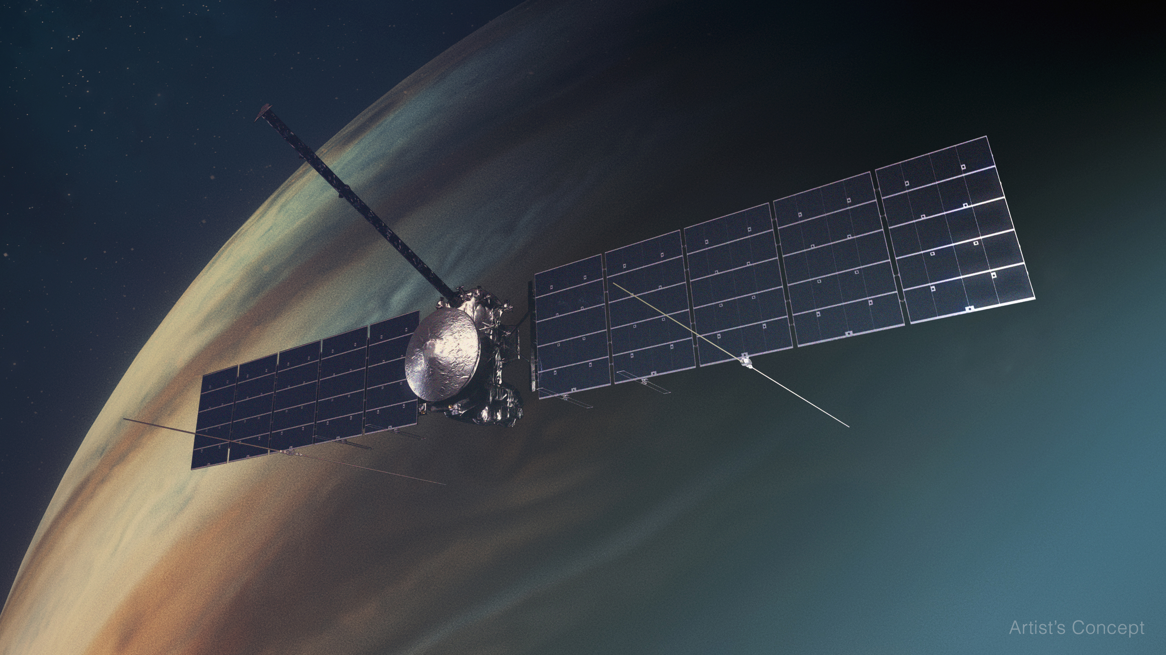
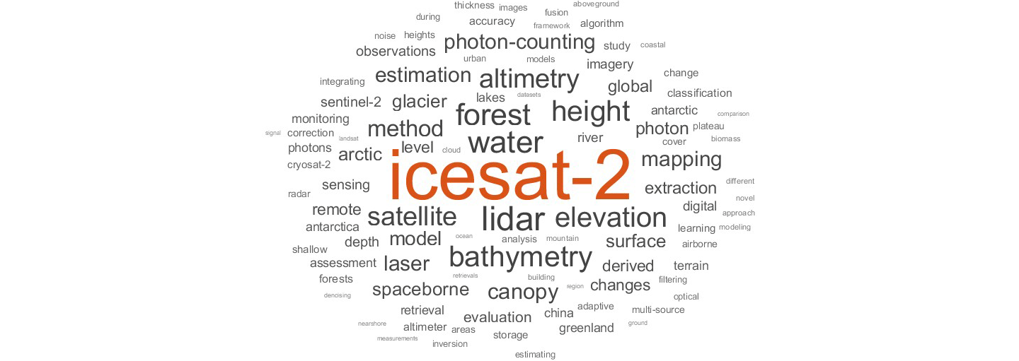
    The NASA Ice, Cloud, and land Elevation Satellite-2 mission (ICESat-2), launched September 15, 2018, continues the first ICESat mission, delivering invaluable global altimetry data. Notwithstanding its icy acronym, ICESat-2 can do more than measure ice – in fact, the expanded acronym hints at these wider applications. From vegetation to inland surface water to bathymetry, ICESat-2 has emerged as a more versatile mission than originally planned, thanks in part to the ingenuity of research scientists, the Science Team (ST), and users of the data – see Figure 1.

    IceSat-2 figure 1
    Figure 1. A word cloud designed to highlight terms that occur most frequently in all ICESat-2 publications since 2018. The larger the word, the more often it is used.
    Figure credit: Aimee Neeley

    ICESat-2 was among the first NASA missions to develop an applications program that engages both scientists and potential users of the science data to accelerate user uptake. Throughout this program, ICESat-2 has demonstrated the value of Earth Observation data to end users, stakeholders, and decision makers. The ICESat-2 Early Adopter (EA; pre-launch) program, now the Applied User program (post-launch), was created to “promote applications research to provide a fundamental understanding of how ICESat-2 data products can be scaled and integrated into organizations, policy, business, and management activities to improve decision making efforts.” This article summarizes the workshop objectives met through plenary talks, lightning talks, an applied user panel, and a breakout session. The ICESat-2 Applications page contains more about the ICESat-2 Applications Program.

    Motivation and Objectives

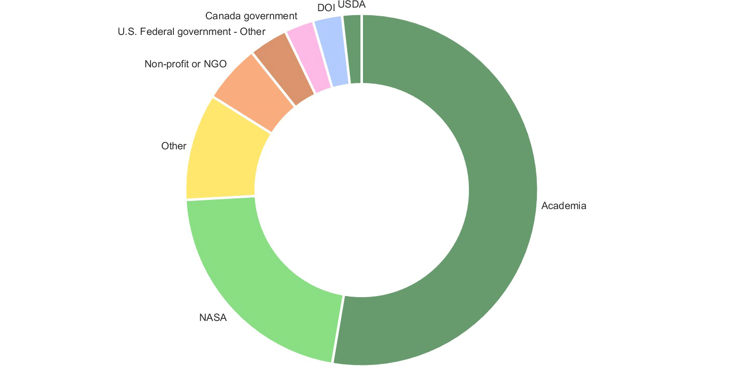
    To meet Applications Program initiatives, the ICESat-2 Applications Team hosted its third Applications workshop June 3–4, 2024 at NASA’s Goddard Space Flight Center (GSFC) in a hybrid environment. A total of 113 participants registered for the workshop, representing multiple government agencies, including NASA Centers, non-profit organizations, and academic organizations – see Figure 2. Approximately 20 individuals attended the workshop in person with the majority participating online through the Webex platform. This workshop provided the space to foster collaboration and to encourage the conceptualization of applications not yet exploited.

    IceSat-2 figure 2
    Figure 2.  A ‘donut’ plot showing the proportion of ICESat-2 Applications Workshop attendees identified by institution. This information was provided during the online registration process.
    Figure credit: Aimee Neeley

    The objectives of the Applications workshop were to:

    1. provide an overview of the mission status, data products, and support services from the National Snow and Ice Data Center (NSIDC);
    2. build partnerships among applied users, data producers, and end users;
    3. foster synergies with all participants, decision makers, and satellite operators;
    4. identify new potential applications or products from ICESat-2;
    5. review available tools for extracting ICESat-2 data; and
    6. understand the challenges faced by applied users, data users, and end users, and identify solutions.

    The remainder of this article will summarize the meeting highlights. Rather than give a strict chronological survey, the report is organized around the meeting objectives listed above. Readers interested in more details can find the full agenda and slide decks from individual presentations mentioned in this summary on the ICESat-2 Workshop website.

    Workshop Overview and Structure

    The agenda of the 2024 ICESat-2 Applications workshop was intended to bring together end-users, including ICESat-2 applications developers, satellite operators, and decision makers from government and nongovernmental entities to discuss the current state and future needs of the community – see Figure 3.

    On the morning of the first day, the workshop participants contributed to a plenary session and ICESat-2 data tool demonstrations. These presentations were intended to provide a broad overview of the ICESat-2 mission, data, science, and applications. Plenary talks during the afternoon session provided an overview of the Earth Science-to-Action initiative and measuring impacts of science. The afternoon also included lightning talks from participants and an Applied User Panel. The second day consisted of a plenary presentation and more lightning talks from participants. The workshop ended with a thematic breakout session with pre-constructed topics and a report out to create a forum for direct interaction between participants.

    IceSat-2 figure 3
    Figure 3. Graphic showing the different levels of data available from the NASA Ice, Cloud, and land Elevation Satellite-2 (ICESat-2) mission.
    Figure credit: NASA, adapted from the National Snow and Ice Data Center (NSIDC) Distributed Active Archive Center’s  ICESat-2 page

    Objective 1: Provide an overview of the status of the mission and current data products and support services from the NSIDC.

    To fulfill the first meeting objective, the workshop included a series of overview presentations given by ICESat-2 team members about the status of the ICESat-2 mission and its data products, as well as a review of the NASA Applied Sciences Program.

    Aimee Neeley [NASA Goddard Space Flight Center (GSFC)/Science Systems and Applications Inc. (SSAI)—ICESat-2 Mission Applications Lead] and Molly Brown [GSFC/University of Maryland—ICESat-2 Mission Applications Scientist] served as cohosts for the event. Neeley opened the first day with a brief overview of workshop goals, logistics, and the agenda. On the second day she gave a brief overview of the agenda for the day and opened it up for questions.

    Thomas Neumann [GSFC—ICESat-2 Project Scientist and Deputy Director of Earth Sciences Division] provided an overview of the ICESat-2 measurement concepts, which includes activity of GPS positioning, pointing angle, altimetry measurements, and ground processing. He continued with an overview of the Advanced Topographic Laser Altimeter System (ATLAS) instrument, the wavelength and spatial resolution of the lasers, and the distributed data products. Neumann presented the mission outlook, with an expected lifespan until December 2035.

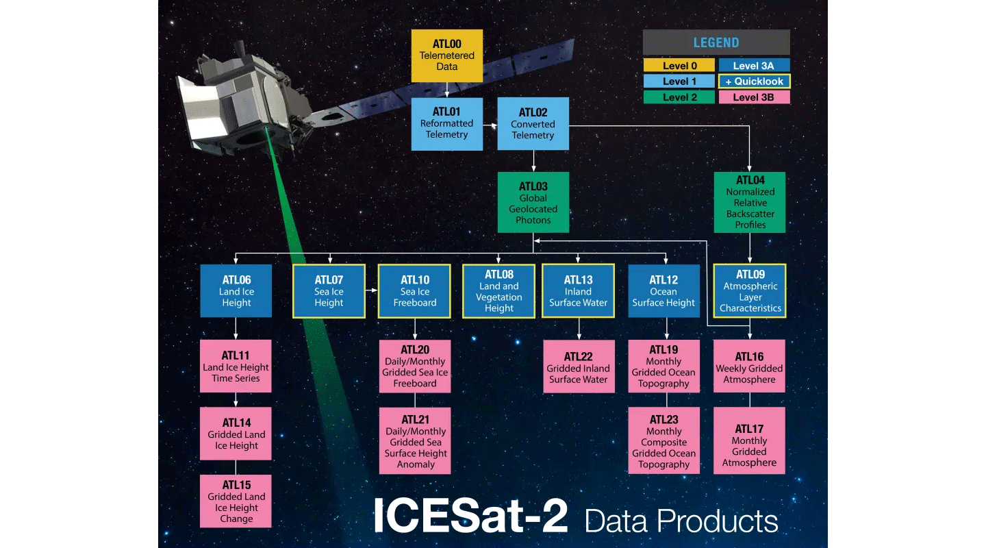
    Walter Meier [University of Colorado, Boulder (UC, Boulder)—NSIDC DAAC Scientist] provided an overview of ICESat-2 data tools and services. He walked the audience through the ICESat-2 data website, as well as the instructional guides that are available for all the tools and services. Meier provided an overview of ICESat-2 standard data products – see Figure 3. Most of the products have a ~45-day latency while quick look data sets have an ~3-day latency. Future data sets include ATL24 and ATL25 and quick look data sets for ATL03, ATL20, and ATL25. Next, he described webinars and tutorials, access tools, and customization services for different users and workflows, including graphical user interfaces and programmatic tools in Earthaccess and the NSIDC website.

    Helen Amanda Fricker [Scripps Institution of Oceanography, University of California (UC), San Diego—ICESat-2 ST Leader and Professor] provided an overview of the ST members and ST goals. Fricker described the ST goals to: 1) provide coordination between the team, project science office, and NASA headquarters; 2) use science talks, posters, and social events to stimulate collaboration within the ST and across disciplines; and 3) maintain the visibility of the ICESat-2 mission through publications, press releases, white papers, open science, and synergies with other missions. Next, Fricker shared the list of ST members that can be found on the ICESat-2 website. She concluded with an overview of a recent publication by Lori Magruder [University of Texas, Austin] and coauthors published in Nature Reviews.

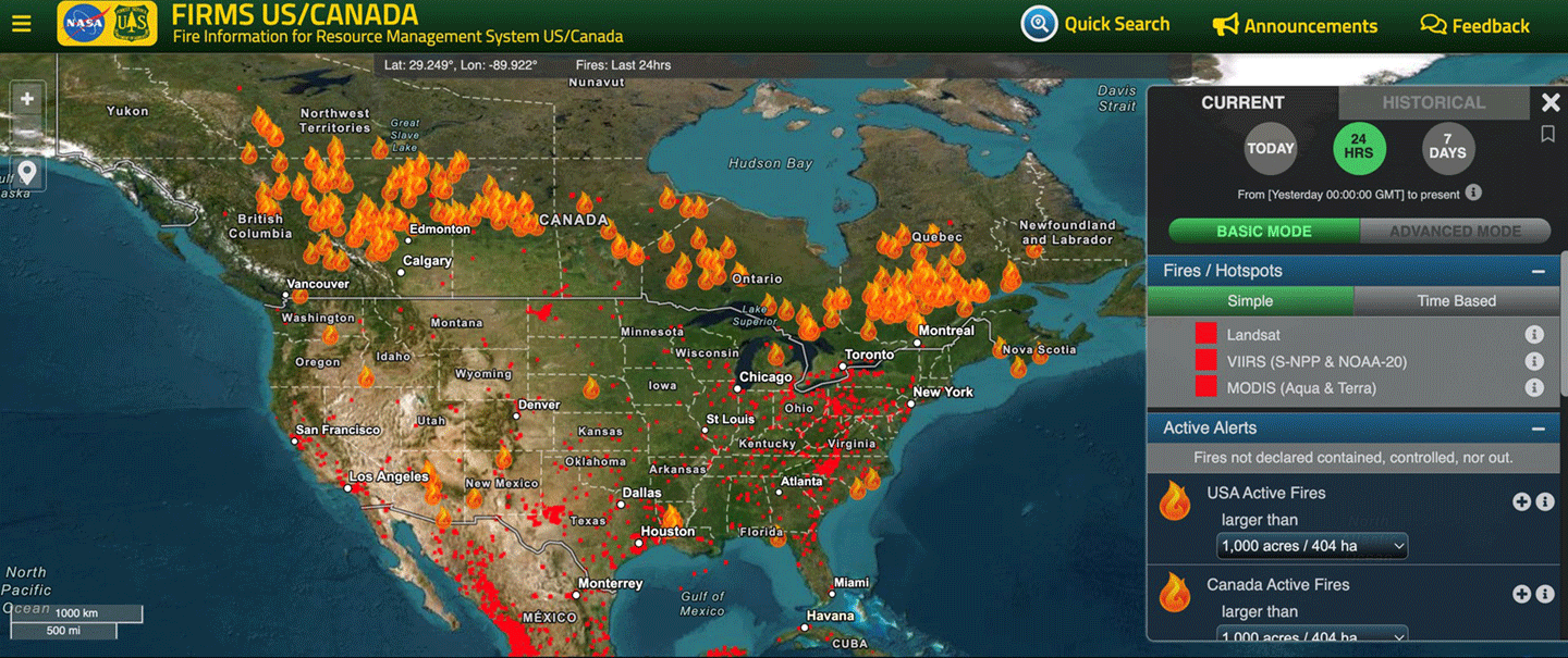
    Stephanie Schollaert Uz [NASA GSFC—Applied Sciences Manager] provided an overview of the NASA Applied Science Program, including the current NASA Earth Science Satellite missions that are monitoring Earth systems. The NASA Applied Science Programs “tackle challenges on our home planet in areas for which Earth science information can respond to the urgent needs of our time.” Earth science data products are used to “inform decisions and actions on management, policy and business.” Uz provided examples of applications using Earth science data, including economic activity, active fire mapping, food security, and monitoring air quality – see Figure 4.

    IceSat-2 figure 4
    Figure 4. Near real-time active fire mapping as well as air quality monitoring and forecasting are available via NASA’s Fire Information for Resource Management System (FIRMS).
    Figure credit: FIRMS U.S./Canada

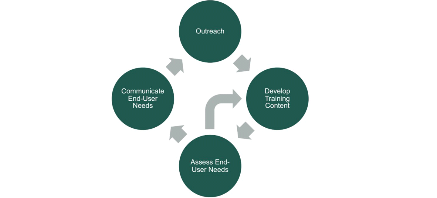
    Molly E. Brown [University of Maryland—ICESat-2 Mission Applications Scientist] began her presentation by defining the term application in the context of this workshop, which includes “innovative uses of mission data products in decision-making activities for societal benefit.” Brown stated that the ICESat-2 Mission Applications program “works to bring our data products into areas where they can help inform policy or decisions that benefit the public.” End users include the private sector, academia, and government agencies. Brown described the benefits of the program and strategies to extend ICESat-2 to new communities – see Figure 5. Brown concluded with an overview of recent publications and new research efforts to assess the impact of ICESat-2 data.

    IceSat-2 figure 5
    Figure 5. Strategies to extend ICESat-2 to new communities through activities and trainings such as those hosted by the Applied Remote Sensing Training (ARSET) program.
    Figure credit: Molly Brown

    Mike Jasinski [NASA GSFC, Hydrological Sciences Laboratory—Assistant Chief for Science] provided an overview of ICESat-2 inland water standard and quick look data products, ATL13QL and ATL22QL. ICESat-2 covers approximately one million lakes each year. Jasinski also listed application areas for water resources decision support, including river elevation and discharge, lake and reservoir water balance and management, and validation of Surface Water and Ocean Topography (SWOT) data. He provided metrics for each data product and quick look product and the advantages and disadvantages of ATL13 and ATL22 data products.

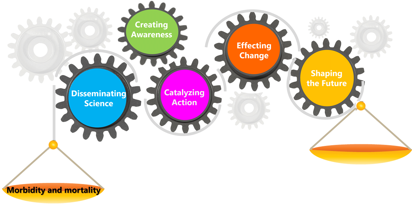
    Mary D. Ari [Centers for Disease Control and Prevention, Office of Science—Senior Advisor for Science] provided an overview of the Science Impact Framework (SIF). Ari explained that our partners and public need “evidence to support practice or policy or decision making, accountability for public finds, and research focus to advocate for research priority.” A major goal is to translate findings into practice or action. Next, she presented ways by which impact can be measured, including bibliometrics (quantitative) and value (qualitative). Ari further explained the Science Impact Framework (SIF), which includes five domains of scientific influence: disseminating science, creating awareness, catalyzing action, effecting change, and shaping the future – see Figure 6.

    IceSat-2 figure 6
    Figure 6. The Science Impact Framework, which allows the impact of scientific work to be quantified and to determine if the science we produce is being put into action.
    Figure credit: Mary Ari

    Woody Turner [NASA Headquarters—ICESat-2 Program Applications Lead] provided an overview of NASA’s Earth Science to Action Strategy. Turner explained that NASA’s Earth Science to Action strategy is integral to the Earth Science Division’s 2024–2034 strategic plan. The overall strategy has two objectives: 1) observe, monitor, and understand the Earth System and 2) deliver trusted information to drive Earth resilience activities. He also summarized the “three key pillars” for this new Earth Action paradigm to 1) be user centered, 2) build bridges between research, technology, flight, data, and Earth Action elements, and 3) scale up existing efforts to get NASA data into the hands of end users. Lastly, Turner listed NASA’s core values, including safety, integrity, inclusion, teamwork, excellence, trustworthiness, innovation, and collaboration.

    Objective 2: Review available tools for extracting ICESat-2 data for a diverse community.

    To achieve this objective, the meeting included a series of presentations in which each speaker described a different tool that is being used to download and analyze ICESat-2 data.

    Jessica Scheick [University of New Hampshire] provided an overview of a set of Python tools, named icepyx, that can be used to obtain and manipulate ICESat-2 data. Scheick, who developed icepyx, described how the tools address challenges with ICESat-2 data. Lastly, she performed a live demonstration of icepyx.

    Tyler Sutterley [Applied Physics Laboratory/University of Washington] presented a live demonstration of Sliderule, an ICESat-2 plugin module that uses an application programming interface (API) to “query a set of ATL03 input granules for photon heights and locations based on a set of photon-input parameters that select the geographic and temporal extent of the request.”

    Joanna D. Millstein [Colorado School of Mines] provided an overview of CryoCloud, which is a “JupyterHub built for NASA cryosphere communities in collaboration with 2i2c.” The goal of CryoCloud is to create a “simple and cost-effective managed cloud environment for training and transitioning new users to cloud workflows and determining community best practices.” CryoCloud makes it possible to “process data faster, minimize downloading and democratize science.” The CryoCloud GitHub provides access to a Slack channel, trainings and tutorials, and community office hours.

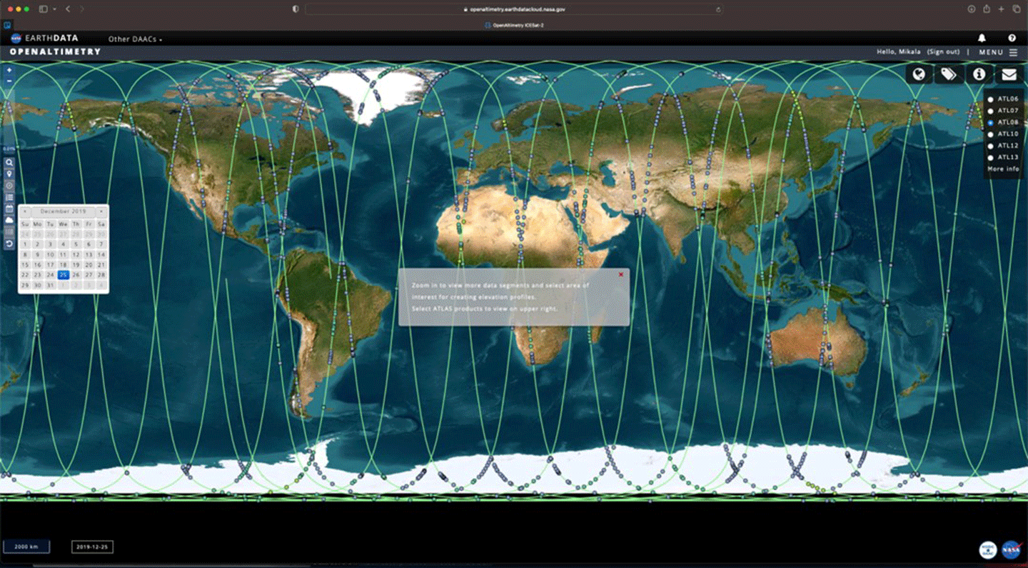
    Mikala Beig [UC, Boulder—NSIDC User Services] provided and overview of OpenAltimetry, a platform for visualizing and downloading surface elevation data from ICESat and ICESat-2. OpenAltimetry was developed to alleviate the challenges faced by researchers, including the “steep learning curves and heavy demands on computational resources” necessary to download and manipulate large volumes of data. The strengths of OpenAltimetry include fostering user engagement, lowering technical hurdles for visualizing data, and allowing deeper data exploration. Lastly, Beig demonstrated the platform for the audience – see Figure 7.

    IceSat-2 figure 7
    Figure 7. Searching ICESat-2 tracks in OpenAltimetry, a map-based data visualization and discovery tool for altimetry data.
    Figure credit: Mikala Beig

    Objectives 3 and 4: Foster synergies between all participants; Identify new potential applications or products from ATLAS data not currently under investigation.

    To meet these two meeting objectives, workshop organizers scheduled a round of lightning talks, where a series of presenters gave five-minute presentations on their research or activities. The talks are distilled below. The reader is directed online to find formal presentation titles and additional information. There was also an applied user panel and a breakout session to facilitate synergies between participants and identify new applications.

    Younghyun Koo [Lehigh University/ Cooperative Institute for Research in Environmental Science (CIRES)] described a method to filter landfast ice (or sea ice “fastened” to the coastline) for accurate examination of thermodynamic and dynamic sea ice features using the ICESat-2 ATL10 data product – see Figure 8.

    Chandana Gangodagamage [OeilSatPrincipal Investigator] described the company’s efforts to track freshwater in the Congo River for the purposes of water resources management and other water-related applications that require river bathymetry data.

    Daniel Scherer [Technischen Universität München (TUM), Germany] provided an overview of the ICESat-2 River Surface Slope (IRIS), a global reach-scale water surface slope dataset that provides average and extreme water slopes from ICESat-2 observations. The data can be dowloaded from Zenodo.

    Louise Croneborg-Jones [Water In SightChief Executive Officer] described her company’s effort to use satellite data and mobile and cloud technology to digitize river and rainfall observation at scale in Malawi. Water In Sight has emphasized getting local communities involved in monitoring water resources to increase observations of water levels for conservation.

    Ravindra Duddu [Vanderbilt University] provided an overview on a project called Modeling Antarctic Iceshelf Calving and Stability (MAGICS), which involves using computation, data, and machine learning to map the rift and crevasse configurations of ice shelves in Antarctica to better understand calving events.

    Shawn Serbin [GSFC] discussed use of harmonized above ground products from ICESat-2 and other earth observing platforms, including Global Ecosystem Dynamics Investigation (GEDI), Soil Moisture Active Passive (SMAP), and Moderate Resolution Imaging Spectroradiometer (MODIS), for terrestrial ecosystem carbon cycle reanalysis and near-term, iterative forecasting for North America and the globe.

    Wengi Ni-Meister [Hunter College of the City University of New York—ICESat-2 Early Adopter] summarized an effort to retrieve canopy and background reflectivity ratio from ICESat-2 data and use it for the retrieval of vegetation cover and snow distribution in boreal forests.

    Morgaine McKibben [GSFC–Plankton, Aerosol, Clouds, ocean Ecosystem (PACE) Applications Lead] provided an overview of NASA’s PACE mission, suggesting possible synergies between ICESat-2 and PACE with the intent of opening the door for further discussion on collaboration between the two missions.  (To learn more about planned applications for PACE, see  Preparing for Launch and Assessing User Readiness: The 2023 PACE Applications Workshop. (Also published in The Earth Observer, Nov–Dec 2023, 35:6, 25–32.)

    Anthony Campbell [GSFC/ University of Maryland, Baltimore County] discussed his group’s research into using ICESat-2 data to monitor changes in coastal wetland migration, including coastal elevation and canopy height.

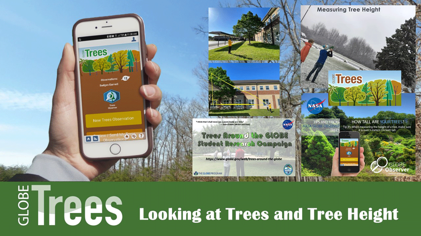
    Brian A Campbell [NASA’s Wallops Flight Facility (WFF)—ICESat-2 Mission Education Lead] described the Global Learning and Observations to Benefit the Environment (GLOBE) program’s network of citizen scientists who collect several different kinds of data using the GLOBE Observer app. He highlighted one data type with particular relevance to ICESat-2. GLOBE Trees – see Figure 8 – equips citizen scientists with the tools to take tree height measurements using their mobile devices. These observations could then be compared to data from NASA satellite missions.

    IceSat-2 figure 8
    Figure 8. NASA’s Global Learning and Observations to Benefit the Environment (GLOBE) has developed an app called GLOBE Trees that allows users take measurements of tree height data using a mobile device. Those data can then be uploaded, and scientists can use them to validate satellite tree height measurement (e.g., from ICESat-2/ATLAS).
    Figure credit: Brian Campbell

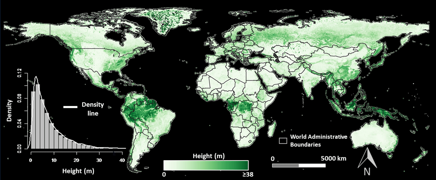
    Caio Hamamura [University of Florida/School of Forest, Fisheries & Geomatics Sciences—Postdoctoral Associate] summarized a literature review his team had conducted of studies using ICESat-2 data for land and vegetation applications as well as results of an assessment of the current capability and limitations of ICESat-2 data for land and vegetation applications – see Figure 9.

    ICESat-2 figure 9
    Figure 9. Illustration of the ATL18 canopy height product at 1 km (~0.6 mi) spatial resolution at the global scale. The height values represent the median of all ATL18 height estimates within a given grid size of 1 km.
    Figure credit: Jordan Borak and Ciao Hamamura

    Jacob Comer [Cultural Site Research and Management Foundation] summarized results from an evaluation of the use of ICESat-2 data for archaeological prospection and documentation of archaeological sites – particularly in the Federal States of Micronesia.

    Juradana M. Iqrah [University of Texas at San Antonio] described her group’s effort to obtain high resolution sea ice classification and freeboard information from ICESat-2 ATL03 observations to understand the impact of global warming on the melting and retreat of polar sea ice cover.

    Michael MacFerrin [National Oceanic and Atmospheric Administration (NOAA) National Centers for Environmental Information (NCEI)—Coastal Digital Elevation (DEM) Model Team] provided an overview of the NOAA/CIRES ICESat-2 Validation of Elevations Reporting Tool (IVERT) tool, which is used to generate land-based validation statistics of digital elevation models (DEM) anywhere in the word using the ATL03 and ATL08 datasets – see Figure 10.

    Figure 10. Digital Elevation Model output before and after Hurricane Michael in Florida, October 2018.
    Figure credit: Michael MacFerrin

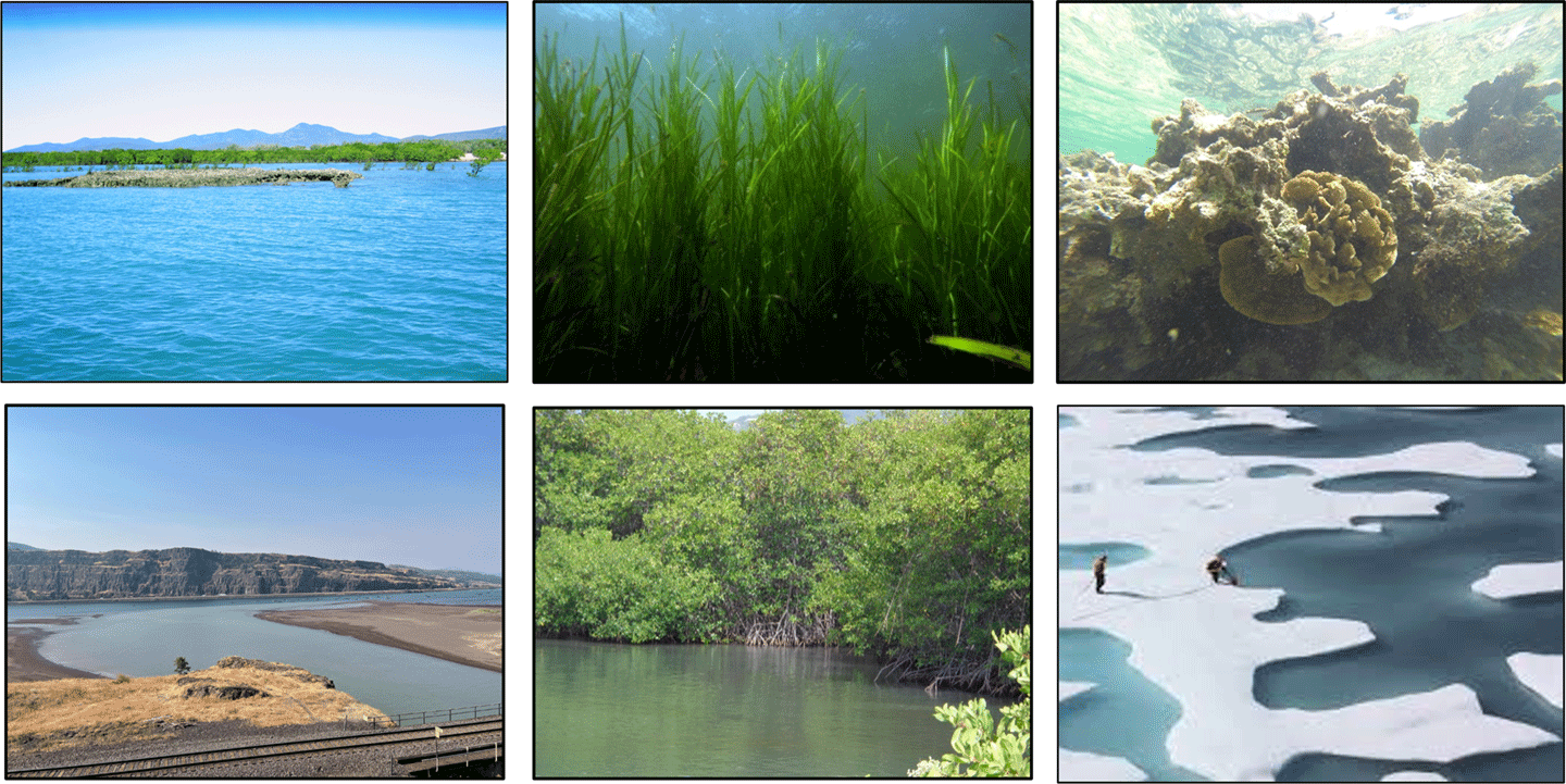
    Gretchen Imahori [NOAA National Geodetic Survey, Remote Sensing Division] presented an overview of satellite derived bathymetry using ICESat-2 data, including the new Level 3 (L3) bathymetry data product (ATL24) that will be available later in 2024 – see Figure 11.

    ICESat-2 figure 11
    Figure 11. Bathymetry data from ICESat-2 have been used across a wide variety of morphologies [some of which are illustrated in the photos above] and disciplines. 
    Figure credit: Gretchen Imahori and the ICESat-2 bathymetry working group

    Objectives 5 and 6: Understand the challenges faced by applied, data users, and end users and identify solutions. Build partnerships between applied users, data producers, and end users.

    To achieve these two objectives, planners organized an applied user panel and a breakout session as means to foster conversation among participants. The applied user panel consisted of five panelists– three participating virtually and two in-person. The presenters in the session shared their responses to three prepared discussion prompts: 1) an introduction of ICESat-2 data products; 2) use of ICESat-2 data products for their application; and 3) potential data latency impacts. The conversation was brief, but it provided a unique opportunity to hear from experienced applied users.

    A breakout session consisted of pre-planned discussion prompts through two virtual breakout groups and one in-person group. Group One discussed questions that covered examination of ice crevassing and rifting, community tools for shallow water mapping, and slope measurement bias and uncertainties. Group Two discussed a variety of current and potential surface water applications, identified challenges using ICEat-2 data, and developed suggestions to increase the accessibility and usability of ICESat-2 data products. Group Three covered a gamut of topics, including potential products for Alaskan and Canadian communities, increased accessibility to products, and applications through central cloud storage systems, central repositories and detailed documentation, and the desire for future topic-specific workshops and focus sessions.

    Conclusion

    The 2024 NASA ICESat-2 Applications Workshop was the third in a series of workshops – with the first workshop occurring in 2012, six years prior to launch. The EA program was transitioned to the Applied User program, which deployed a post-launch program per the NASA Early Adopter Handbook “that acts as a continuation of the Early Adopter program to engage with Communities of Practice and Potential.” This workshop provided the space to foster collaboration and conceptualization of applications not yet exploited that may be developed using ICESat-2 data products. The workshop met its objectives and created an environment that fostered collaboration between participants. The workshop was a success, and participants requested another one focused on a thematic topic. Updates, future workshops, and other events will be posted on the ICESat-2 ‘Get Involved’ page.

    Aimee Renee Neeley
    NASA’s Goddard Space Flight Center/Science Systems and Applications, Inc.

    aimee.neeley@nasa.gov

    Details

    Last Updated

    Sep 17, 2024

    Related Terms

  • Engineer Zaida Hernandez

    Zaida Hernandez, a hispanic woman with long wavy brown hair and dark brown eyes, smiles brightly at the camera while sitting inside a mock up of NASA's Orion Crew Capsule. She's wearing a blue blazer and flight hardware is seen all around her.

    “I would say family and part of that ‘first-gen experience’ [shaped me]. Being born in the U.S. gave me a lot of opportunities that my family and parents were robbed of because of situations in their home country. It shaped me to be a hard worker and to aspire to large things because not only was it my goal at this point, but it was also my parents’ aspiration.

    “I feel that a lot of their pride comes from their kids. That pushes me to be a better employee or to want to do better for myself because I know that they’ve made a lot of sacrifices for me while I was building up to becoming an engineer. Now that I’ve accomplished my goal, it’s very important for me to always thank them and be a grateful person.

    “Culture also shaped me. Coming from a minority background, and I’m only familiar with the Hispanic culture, it was an education-first mindset…and very supportive. I think that’s important. When I do outreach, I always like to share my experiences because sometimes, people don’t realize how much impact they can have, like the teacher who told me about [a NASA] internship. She didn’t know that was going to be my career. Or, my mom staying up with me during late night study sessions when I was like, ‘I can’t be an engineer’ and failed a test and she was like, ‘No, you can do it. I believe in you.’ 

    “It might not be memorable for the person who [says it], but it was super important for my motivation to keep going. So, [online, I am that voice for] first-gen motivation.” 

    – Zaida Hernandez, Engineer, Lunar Architecture Team, NASA Johnson Space Center

    Image Credit: NASA/Bill Stafford
    Interviewer: NASA/Tahira Allen

    Check out some of our other Faces of NASA. 

  • Reaching New Heights to Unravel Deep Martian History!

    2 min read

    Reaching New Heights to Unravel Deep Martian History!

    This is an image of the rim that the Perseverance rover took on sol 383 (March 18th, 2022) when it was traversing the crater floor. Dox Castle is located at the top of the image in the far ground.
    This is an image of the rim that the Perseverance rover took on sol 383 (March 19th, 2022) when it was traversing the crater floor. Dox Castle is located at the top of the image in the far ground.
    NASA/JPL-Caltech/ASU

    The Perseverance rover is reaching new heights as it ascends the rim of Jezero crater (over 300 meters in elevation higher than the original landing site)! The rover is now enroute to its first campaign science stop Dox Castle (image in the far ground) a region of interest for its potential to host ancient Mars’ bedrock in the exposed rocks on the rim.

    Impact craters like Jezero may be the key to piecing together the early geologic history of Mars, as they provide a window into the history of the ancient crust by excavating and depositing deep crustal materials above the surface. Crater rims act as keepers of ancient Martian history, uplifting and exposing the stratigraphy of these impacted materials. Additionally, extreme heat from the impact can encourage the circulation of fluids through fractures similar to hydrothermal vents, which have implications for early habitability and may be preserved in the exposed rim bedrock. With the Perseverance rover we have the potential to explore some of the oldest exposed rocks on the planet.

    Exploring such diverse terrains takes a lot of initial planning! The team has been preparing for the Crater Rim Campaign these last few months by working together to map out the types of materials Perseverance may encounter during its traverse up and through the rim. Using orbital images from the High-Resolution Imaging Science Experiment (HiRISE) instrument, the science team divided the rim area into 36 map quadrants, carefully mapping different rock units based on the morphologies, tones, and textures they observed in the orbital images. Mapping specialists then connected units across the quads to turn 36 miniature maps into one big geologic map of the crater rim. This resource is being used by the team to plan strategic routes to scientific areas of interest on the rim.

    On Earth, geologic maps are made using a combination of orbital images and mapping in the field. Planetary scientists don’t typically get to check their map in the field, but we have the unique opportunity to validate our map using our very own robot geologist! Dox Castle will be our first chance to do rim science – and we’re excited to search for evidence of the transition between the margin and rim materials to start piecing together the stratigraphic history of the rocks that make up the rim of Jezero crater.

    Written by Margaret Deahn, Ph.D. student at Purdue University

    Details

    Last Updated

    Sep 16, 2024

    Related Terms

  • Station Science Top News: September 13, 2024

    JAXA (Japan Aerospace Exploration Agency) researchers examined the structures of four titanium-based compounds solidified in levitators in microgravity and on the ground and found that the internal microstructures were generally similar. These results could support development of new materials for use in space manufacturing.

    To produce glass or metal alloys on Earth, raw materials are placed into a container and heated. But reactions between the container and the materials can cause imperfections. The JAXA Electrostatic Levitation Furnace can levitate, melt, and solidify materials without a container. The facility enables measurement of the thermophysical properties of high temperature melts and could accelerate development of innovative materials such as heat resistant ceramics for use in the aerospace and energy industries.

    An astronaut wears safety glasses and a face mask while working with a large, box-like scientific apparatus inside the International Space Station.
    JAXA (Japan Aerospace Exploration Agency) astronaut Akihiko Hoshide works with the Electrostatic Levitation Furnace.
    European Space Agency/Thomas Pesquet

    Satellite 3D imaging of a Peruvian tropical forest demonstrated that measuring leaf traits with remote sensing may provide more accurate predictions of biomass production than structure data such as tree height. Carbon stored or sequestered in forests can help offset emissions that cause climate change, and improved estimates of tropical forest biomass could allow researchers to better evaluate these ecosystems and their offset contributions.

    Global Ecosystem Dynamics Investigation (GEDI) provides high-resolution global observations of Earth’s forests and topography. These observations provide information on carbon and water cycling processes, biodiversity, and habitat, including quantifying carbon stored in vegetation and the potential for future carbon storage. The researchers suggest that estimates of tropical forest biomass could be further improved with data from new satellite missions and by integrating GEDI with dynamic vegetation models that include trait data.

    Learn more from this video and this article.

    Exterior view of a white scientific instrument attached to the outside of the International Space Station, with Earth visible in the background.
    The refrigerator-sized Global Ecosystem Dynamics Investigation instrument on the exterior of the International Space Station.
    NASA/Nick Hague

    Research indicates that refractive eye surgery is safe, effective, and suitable for astronauts. The study documented stable vision in two astronauts who, a few years prior to flight, underwent photorefractive keratectomy (PRK) and laser-assisted in situ keratomileusis (LASIK), respectively. These visual correction procedures can reduce the logistical complications of wearing glasses or contact lenses in space.

    International Space Station Medical Monitoring collects health data from crew members before, during, and after spaceflight.  The medical evaluation requirements, including vision assessment, apply to all crew members and are part of efforts by all international partners to maintain crew health, ensure mission success, and enable crew members to return to normal life on Earth after their missions.

    Two astronauts float inside a densely packed laboratory module on the International Space Station, surrounded by a complex array of scientific equipment, cables, and instruments.
    NASA astronauts Terry Virts (bottom) and Scott Kelly (top) perform eye exams as part of ongoing studies into crew vision health.
    NASA

    JAXA researchers report that accurately assessing the velocity of airflow in front of a spreading flame makes it possible to predict the flammability of thin, flat materials in microgravity. These results mean it could be possible to use ground tests to predict the flammability of solid materials and thus ensure fire safety in spacecraft and space habitations.

    The JAXA Fundamental Research on International Standard of Fire Safety in Space – Base for Safety of Future Manned Missions (FLARE) investigation tested the flammability of various solid materials in different configurations, including filter paper. Microgravity significantly affects combustion phenomena such as the spread of flame over solid materials; while flames cannot spread over solid materials under low-speed oxygen flow in Earth’s gravity, they can in microgravity due to the lack of buoyancy. Testing of the flammability of materials for spacecraft previously has not considered the effect of gravity, and results from this investigation could address this issue, significantly improving fire safety on future exploration missions.

    JAXA astronaut Satoshi Furukawa sets up hardware for the Fundamental Research on International Standard of Fire Safety in Space – Base for Safety of Future Manned Missions investigation.
    NASA/Jasmin Moghbeli
  • Ottawa’s Fall Rhapsody

    Orange tree leaves cover the left side of the aerial image of Ottawa, Canada. To the right, streets, buildings, and other city infrastructure is visible. A waterway splits the image horizontally through the middle; another river also travels from top to bottom slightly right of center.
    NASA

    An astronaut aboard the International Space Station captured this view of peak fall foliage around Ottawa, Canada on Oct. 14, 2020. Sugar maple leaves turn orange-red, and hickories turn golden-bronze during autumn, regionally known as “the Fall Rhapsody.”

    Fall color reaches its peak when air temperatures drop and shortened daylight triggers plants to slow and stop the production of chlorophyll—the molecule that plants use to synthesize food. When the green chlorophyll pigment fades, various yellow and red pigments become visible.

    Image credit: NASA EUSO

  • NASA Ames Selects Aeronautics and Exploration Support Contractor

    The letters NASA on a blue circle with red and white detail, all surrounded by a black background
    Credit: NASA

    NASA has awarded the NASA Academic Mission Services 2 (NAMS-2) contract to Crown Consulting Inc., of Arlington, Virginia, to provide the agency’s Ames Research Center in California’s Silicon Valley, aeronautics and exploration technology research and development support.

    NAMS-2 is a single award hybrid cost-plus-fixed-fee indefinite-delivery indefinite-quantity contract with a maximum potential value of $121 million. The contract begins Tuesday, Oct. 1, 2024, with a 60-day phase-in period, followed by a two-year base period, and options to extend performance through November 2029.

    Under this contract, the company will support a broad scope of scientific research and development of new and emerging capabilities and technologies associated with air traffic management, advanced technology, nanoelectronics, and prototype software in support of the Aeronautics Directorate and the Exploration Technology Directorate at NASA Ames. The work also will focus on the improvement of aircraft and airspace safety, as well as the transition of advanced aeronautics technologies into future air vehicles.

    For information about NASA and agency programs, visit:

    https://www.nasa.gov

    -end-

    Roxana Bardan
    Headquarters, Washington
    202-358-1600
    roxana.bardan@nasa.gov

    Rachel Hoover
    Ames Research Center, Silicon Valley, Calif.
    rachel.hoover@nasa.gov
    650-604-4789

    Details

    Last Updated

    Sep 13, 2024

  • Waxing Gibbous Moon over Minnesota

    The waxing gibbous Moon looks nearly full in the darkness of space.
    NASA, ESA/Matthias Maurer

    An astronaut aboard the International Space Station snapped this picture of the Moon as the station orbited 265 miles above the U.S. state of Minnesota on Dec. 17, 2021.

    Astronauts aboard the orbital lab take images using handheld digital cameras, usually through windows in the station’s cupola, for Crew Earth Observations. Crew members have produced hundreds of thousands of images of the Moon and Earth’s land, oceans, and atmosphere.

    On Saturday, Sept. 14, 2024, International Observe the Moon Night, everyone on Earth is invited to learn about lunar science, participate in celestial observations, and honor cultural and personal connection to the Moon. Find an event to join in the celebration.

    Image credit: NASA, ESA/Matthias Maurer

  • NASA’s Lunar Challenge Participants to Showcase Innovations During Awards

    A sunrise view of the hangar at NASA's Glenn Research Center
    The Sun rises above the Flight Research Building at NASA’s Glenn Research Center in Cleveland.
    Credit: NASA

    Editor’s note: This media advisory was updated Friday, Sept. 13, 2024, with a correct phone number for the media contact at NASA’s Glenn Research Center.

    NASA‘s Watts on the Moon Challenge, designed to advance the nation’s lunar exploration goals under the Artemis campaign by challenging United States innovators to develop breakthrough power transmission and energy storage technologies that could enable long-duration Moon missions, concludes on Friday, Sept. 20, at the Great Lakes Science Center in Cleveland.

    “For astronauts to maintain a sustained presence on the Moon during Artemis missions, they will need continuous, reliable power,” said Kim Krome-Sieja, acting program manager, Centennial Challenges at NASA’s Marshall Space Flight Center in Huntsville, Alabama. “NASA has done extensive work on power generation technologies. Now, we’re looking to advance these technologies for long-distance power transmission and energy storage solutions that can withstand the extreme cold of the lunar environment.”

    The technologies developed through the Watts on the Moon Challenge were the first power transmission and energy storage prototypes to be tested by NASA in an environment that simulates the extreme cold and weak atmospheric pressure of the lunar surface, representing a first step to readying the technologies for future deployment on the Moon. Successful technologies from this challenge aim to inspire, for example, new approaches for helping batteries withstand cold temperatures and improving grid resiliency in remote locations on Earth that face harsh weather conditions.

    Media and the public are invited to attend the grand finale technology showcase and awards ceremony for the $5 million, two-phase competition. U.S. and international media interested in covering the event should confirm their attendance with Lane Figueroa by 3 p.m. CDT Tuesday, Sept. 17, at: lane.e.figueroa@nasa.gov. NASA’s media accreditation policy is available online. Members of the public may register as an attendee by completing this form, also by Friday, Sept. 17.

    During the final round of competition, finalist teams refined their hardware and delivered a full system prototype for testing in simulated lunar conditions at NASA’s Glenn Research Center in Cleveland. The test simulated a challenging power system scenario where there are six hours of solar daylight, 18 hours of darkness, and the user is three kilometers from the power source.

    “Watts on the Moon was a fantastic competition to judge because of its unique mission scenario,” said Amy Kaminski, program executive, Prizes, Challenges, and Crowdsourcing, Space Technology Mission Directorate at NASA Headquarters in Washington. “Each team’s hardware was put to the test against difficult criteria and had to perform well within a lunar environment in our state-of-the-art thermal vacuum chambers at NASA Glenn.”

    Each finalist team was scored based on Total Effective System Mass (TESM), which determines how the system works in relation to its mass. At the awards ceremony, NASA will award $1 million to the top team who achieves the lowest TESM score, meaning that during testing, that team’s system produced the most efficient output-to-mass ratio. The team with the second lowest mass will receive $500,000. The awards ceremony stream live on NASA Glenn’s YouTube channel and NASA Prize’s Facebook page.

    The Watts on the Moon Challenge is a NASA Centennial Challenge led by NASA Glenn. NASA Marshall manages Centennial Challenges, which are part of the agency’s Prizes, Challenges, and Crowdsourcing program in the Space Technology Mission Directorate. NASA has contracted HeroX to support the administration of this challenge.

    For more information on NASA’s Watts on the Moon Challenge, visit:

    https://www.nasa.gov/wattson

    -end- 

    Jasmine Hopkins
    Headquarters, Washington
    321-432-4624
    jasmine.s.hopkins@nasa.gov

    Lane Figueroa
    Marshall Space Flight Center, Huntsville, Ala.
    256-932-1940
    lane.e.figueroa@nasa.gov

    Brian Newbacher
    Glenn Research Center, Cleveland
    216-469-9726
    brian.t.newbacher@nasa.gov

  • Sols 4302-4303: West Side of Upper Gediz Vallis, From Tungsten Hills to the Next Rocky Waypoint

    3 min read

    Sols 4302-4303: West Side of Upper Gediz Vallis, From Tungsten Hills to the Next Rocky Waypoint

    This photo taken by NASA’s Mars rover Curiosity of ‘Balloon Dome’ covers a low dome-like structure formed by the light-toned slab-like rocks. This image was taken by Left Navigation Camera aboard Curiosity on Sol 4301 — Martian day 4,301 of the Mars Science Laboratory mission — on Sept. 11, 2024, at 09:14:42 UTC.
    NASA/JPL-Caltech

    Earth planning date: Wednesday, Sept. 11, 2024

    The rover is on its way from the Tungsten Hills site to the next priority site for Gediz Vallis channel exploration, in which we plan to get in close enough for arm science to one of the numerous large dark-toned “float” blocks in the channel and also to one of the light-toned slabs.  We have seen some dark blocks in the channel that seem to be related to the Stimson formation material that the rover encountered earlier in the mission, but some seem like they could be something different. We don’t think any of them originated in the channel so they have to come from somewhere higher up that the rover hasn’t been, and we’re interested in how they were transported down into the channel.

    We aren’t there yet, but the 4302-4303 plan’s activities include some important longer-range characterization of the dark-toned and light-toned materials via imaging. Context for the future close-up science on the dark-toned blocks will be provided by the Mastcam mosaics named “Bakeoven Meadow” and “Balloon Dome.”  The broad Balloon Dome mosaic also covers a low dome-like structure formed by the light-toned slab-like rocks (pictured).  Smaller mosaics will cover a pair of targets that include contacts where other types of light-toned and dark-toned material occur next to each other in the same block: “Rattlesnake Creek” which appears to be in place, and “Casa Diablo Hot Springs,” which is a float.

    The rover’s arm workspace provided an opportunity for present-day aeolian science on the sandy-looking ripple, Sandy Meadow. Mastcam stereo imaging will document the shape of the ripple, while a suite of high-resolution MAHLI images will tell us something about the particle size of the grains in it.  The modern environment will also be monitored via a suprahorizon observation, a dust devil survey, and imaging of the rover deck to look for dust movement.

    The workspace included small examples of the dark float blocks, so the composition of one of them will be measured by both APXS and ChemCam LIBS as targets “Lucy’s Foot Pass” and “Colt Lake” respectively.

    In the meantime, the Mastcam Boneyard Meadow mosaic will provide a look back at the Tungsten Hills dark rippled block along its bedding plane to try to narrow down the origin of the ripples and the potential roles of water vs. wind in their formation.

    Communication remains a challenge for the rover in this location. During planning, the rover’s drive was shifted from the second sol to the first sol in order to increase the downlink data volume available for the post-drive imaging, thereby enabling better planning at the science waypoint we expect to reach in the weekend plan. However, maintaining communications will require the rover to end its drive in a narrow range of orientations, which could make approaching our next science target a bit tricky.  We’ll find out on Friday!

    Written by: Lucy Lim, Planetary Scientist at NASA Goddard Space Flight Center
    Edited by: Abigail Fraeman, Planetary Geologist at NASA’s Jet Propulsion Laboratory

    Details

    Last Updated

    Sep 13, 2024

    Related Terms

  • Testing Europa Clipper’s Solar Arrays

    Large black rectangular solar arrays stretch out from the foreground to the back.
    NASA/Frank Michaux

    On Aug. 21, 2024, engineers and technicians deployed and tested NASA’s Europa Clipper giant solar arrays. Each array measures about 46.5 feet (14.2 meters) long and about 13.5 feet (4.1 meters) high.

    Europa Clipper is scheduled to launch Oct. 10, 2024, on the first mission to conduct a detailed science investigation of Jupiter’s moon Europa. Scientists predict Europa has a salty ocean beneath its icy crust that could hold the building blocks necessary to sustain life.

    Learn how this spacecraft’s solar arrays will power flybys.

    Image credit: NASA/Frank Michaux

  • NASA’s SpaceX Crew-9 to Conduct Space Station Research

    The station pictured from the SpaceX Crew Dragon
    The International Space Station is pictured from the SpaceX Crew Dragon Endeavour during a fly around.
    NASA

    NASA astronaut Nick Hague and Roscosmos cosmonaut Aleksandr Gorbunov are headed to the International Space Station for the agency’s SpaceX Crew-9 mission in September. Once on station, these crew members will support scientific investigations that include studies of blood clotting, effects of moisture on plants grown in space, and vision changes in astronauts.

    Here are details on some of the work scheduled during the Crew-9 expedition:

    Blood cell development in space

    Megakaryocytes Orbiting in Outer Space and Near Earth (MeF1) investigates how environmental conditions affect the development and function of megakaryocytes and platelets. Megakaryocytes, large cells found in bone marrow, and platelets, pieces of these cells, play important roles in blood clotting and immune response.

    “Understanding the development and function of megakaryocytes and platelets during long-duration spaceflight is crucial to safeguarding the health of astronauts,” said Hansjorg Schwertz, principal investigator, at the University of Utah. “Sending megakaryocyte cell cultures into space offers a unique opportunity to explore their intricate differentiation process. Microgravity also may impact other blood cells, so the insights we gain are likely to enhance our overall comprehension of how spaceflight influences blood cell production.”

    Results could provide critical knowledge about the risks of changes in inflammation, immune responses, and clot formation in spaceflight and on the ground.

    Two side-by-side black and white images show highly magnified individual platelets, which are roundish, pockmarked spheres with several small, arm-like protrusions.
    Scanning electron-microscopy image of human platelets prior to launch to the International Space Station.
    University of Utah/Megakaryocytes PI Team

    Patches for NICER

    The Neutron Star Interior Composition Explorer (NICER) telescope on the exterior of the space station measures X-rays emitted by neutron stars and other cosmic objects to help answer questions about matter and gravity.

    In May 2023, NICER developed a “light leak” that allows sunlight to interfere with daytime measurements. Special patches designed to cover some of the damage will be installed during a future spacewalk, returning the instrument to around-the-clock operation.

    “This will be the fourth science observatory and first X-ray telescope in orbit to be repaired by astronauts,” said principal investigator Keith Gendreau at NASA’s Goddard Space Flight Center in Greenbelt, Maryland. “In just a year, we diagnosed the problem, designed and tested a solution, and delivered it for launch. The space station team — from managers and safety experts to engineers and astronauts — helped us make it happen. We’re looking forward to getting back to normal science operations.”

    : NICER’s X-ray concentrators are dark circles in eight staggered rows covering this image. Each one is divided into six segments, like a sliced pie, by its sunshade. The concentrators rest in a white frame of the telescope.
    This view shows NICER’s 56 X-ray concentrators. Astronauts plan to cover some of them with special patches on a future spacewalk.
    NASA

    Vitamins for vision

    Some astronauts experience vision changes, a condition called Spaceflight-Associated Neuro-ocular Syndrome. The B Complex investigation tests whether a daily B vitamin supplement can prevent or mitigate this problem and assesses how genetics may influence individual response.

    “We still do not know exactly what causes this syndrome, and not everyone gets it,” said Sara Zwart, principal investigator, at the University of Texas Medical Branch, Houston. “It is likely many factors, and biological variations that make some astronauts more susceptible than others.”

    One such variation could be related to a metabolic pathway that requires B vitamins to function properly. Inefficiencies in this pathway can affect the inner lining of blood vessels, resulting in leaks that may contribute to vision changes. Providing B vitamins known to affect blood vessel function positively could minimize issues in genetically at-risk astronauts.

    “The concept of this study is based on 13 years of flight and ground research,” Zwart said. “We are excited to finally flight test a low-risk countermeasure that could mitigate the risk on future missions, including those to Mars.”

    NASA astronaut Mark Vande Hei gets his eyes checked
    NASA astronaut Mark Vande Hei conducts a vision exam on the International Space Station
    NASA

    Watering the space garden

    As people travel farther from Earth for longer, growing food becomes increasingly important. Scientists conducted many plant growth experiments on the space station using its Veggie hardware, including Veg-01B, which demonstrated that ‘Outredgeous’ red romaine lettuce is suitable for crop production in space.

    Plant Habitat-07 uses this lettuce to examine how moisture conditions affect the nutritional quality and microbial safety of plants. The Advanced Plant Habitat controls humidity, temperature, air, light, and soil moisture, creating the precise conditions needed for the experiment.

    Using a plant known to grow well in space removes a challenging variable from the equation, explained Chad Vanden Bosch, principal investigator at Redwire, and this lettuce also has been proven to be safe to consume when grown in space.

    “For crews building a base on the Moon or Mars, tending to plants may be low on their list of responsibilities, so plant growth systems need to be automated,” Bosch said. “Such systems may not always provide the perfect growing conditions, though, so we need to know if plants grown in suboptimal conditions are safe to consume.”

    Large crinkly leaves fill two sides of the plant habitat, with a screen dividing them. There are hoses and cords to the left of the plants, which are bathed in a reddish light.
    This preflight image shows lettuce grown under control (left) and flood (right) moisture treatments.
    Plant Habitat-07 team

    Melissa Gaskill

    International Space Station Research Communications Team

    NASA’s Johnson Space Center

    Search this database of scientific experiments to learn more about those mentioned in this article.

  • NASA Astronaut Don Pettit, Crewmates Arrive at Space Station

    The Soyuz rocket launches to the International Space Station with Expedition 72 crew members: NASA astronaut Don Pettit, Roscosmos cosmonauts Alexey Ovchinin, and Ivan Vagner, onboard, Wednesday, Sept. 11, 2024, at the Baikonur Cosmodrome in Kazakhstan.
    Credit: NASA/Bill Ingalls

    NASA astronaut Don Pettit, accompanied by Roscosmos cosmonauts Alexey Ovchinin and Ivan Vagner, arrived at the International Space Station Wednesday, bringing its number of residents to 12 for the 13-day handover period.

    After a two-orbit, three-hour journey to the station, the Roscosmos Soyuz MS-26 spacecraft automatically docked to the orbiting laboratory’s Rassvet module at 3:32 p.m. EDT. The spacecraft launched at 12:23 p.m. EDT (9:23 p.m. Baikonur time) from the Baikonur Cosmodrome in Kazakhstan.

    NASA’s coverage of hatch opening will stream at 5:30 p.m. on NASA+, the NASA app, YouTube, and the agency’s website. Hatch opening is scheduled to begin at 5:50 p.m. Learn how to stream NASA content through a variety of platforms, including social media.

    Once aboard, the trio will join Expedition 71 crew members, including NASA astronauts Tracy C. Dyson, Mike Barratt, Matthew Dominick, Jeanette Epps, Butch Wilmore, and Suni Williams, as well as Roscosmos cosmonauts Nikolai Chub, Alexander Grebenkin, and Oleg Kononenko. Expedition 72 will begin Monday, Sept. 23, upon the departure of Dyson, Chub, and off-going station commander Kononenko, completing a six-month stay for Dyson and a year-long expedition for Chub and Kononenko.

    Pettit, Ovchinin, and Vagner will spend approximately six months aboard the orbital outpost advancing scientific research as Expedition 71/72 crew members before returning to Earth in the spring of 2025. This is Pettit and Ovchinin’s fourth spaceflight and Vagner’s second.

    During Expedition 72, two new crews will arrive aboard the space station, including NASA’s SpaceX Crew-9 launching in September, followed by Crew-10, scheduled for launch in February 2025.  

    Follow Pettit on X throughout his mission and get the latest space station crew news on Instagram, Facebook, and X.

    Learn more about International Space Station research and operations at:

    https://www.nasa.gov/station

    -end-

    Joshua Finch / Claire O’Shea
    Headquarters, Washington
    202-358-1100
    joshua.a.finch@nasa.gov / claire.a.o’shea@nasa.gov

    Leah Cheshier
    Johnson Space Center, Houston
    281-483-5111
    leah.d.cheshier@nasa.gov

  • NASA to Preview Europa Clipper Mission to Jupiter Moon

    This artist’s concept depicts NASA’s Europa Clipper spacecraft in orbit around Jupiter. The mission is targeting an Oct. 10, 2024, launch.
    NASA/JPL-Caltech

    NASA will host a news conference at 11 a.m. EDT Tuesday, Sept. 17, at the agency’s Jet Propulsion Laboratory in Southern California to discuss the upcoming Europa Clipper mission to Jupiter’s icy moon Europa.

    The briefing will be open to media and will air live on NASA+ and the agency’s website, plus Facebook, X, and YouTube. Learn how to stream NASA content through a variety of platforms, including social media.

    Participants in the news conference include:

    • Gina DiBraccio, acting director, Planetary Science Division, NASA Headquarters
    • Jordan Evans, project manager, Europa Clipper, NASA’s Jet Propulsion Laboratory
    • Bonnie Buratti, deputy project scientist, Europa Clipper, JPL
    • Stuart Hill, propulsion module delivery manager, Johns Hopkins University Applied Physics Laboratory
    • Armando Piloto, senior mission manager, NASA’s Launch Services Program

    To ask questions by phone, members of the media must RSVP no later than two hours before the start of the event to Rexana Vizza at: rexana.v.vizza@jpl.nasa.gov.

    Members of the news media from the U.S. and non-designated countries who are interested in covering the event in person at JPL must arrange access in advance by contacting Rexana Vizza at: rexana.v.vizza@jpl.nasa.gov no later than 3 p.m. EDT (12 p.m. PDT) on Thursday, Sept. 12. Media representatives must provide one form of government-issued photo identification. Non-U.S. citizens will need to bring a passport or a green card. NASA’s media accreditation policy is available online.

    Questions can be asked on social media during the briefing using the hashtag #AskNASA.

    Europa is one of the most promising places in our solar system to find an environment suitable for life beyond Earth. Evidence suggests that the ocean beneath Europa’s icy surface could contain the ingredients for life — water, the right chemistry, and energy. While Europa Clipper is not a life-detection mission, it will answer key questions about the moon’s potential habitability.

    Europa Clipper’s launch period opens on Thursday, Oct. 10. The spacecraft, the largest NASA has ever built for a planetary mission, will launch on a SpaceX Falcon Heavy rocket from Launch Complex 39A at NASA’s Kennedy Space Center in Florida.

    Managed by Caltech in Pasadena, California, JPL leads the development of the Europa Clipper mission in partnership with the Johns Hopkins Applied Physics Laboratory (APL) in Laurel, Maryland, for NASA’s Science Mission Directorate in Washington. The main spacecraft body was designed by APL in collaboration with JPL and NASA’s Goddard Space Flight Center in Greenbelt, Maryland. The Planetary Missions Program Office at NASA’s Marshall Space Flight Center in Huntsville, Alabama, executes program management of the Europa Clipper mission. NASA’s Launch Services Program, based at Kennedy, manages the launch service for the Europa Clipper spacecraft.

    To learn more about Europa Clipper, visit:

    https://europa.nasa.gov

    -end-

    Karen Fox / Molly Wasser
    Headquarters, Washington
    202-358-1600
    karen.c.fox@nasa.gov / molly.l.wasser@nasa.gov

    Val Gratias / Gretchen McCartney
    Jet Propulsion Laboratory, Pasadena, Calif.
    626-318-2141 / 818-393-6215
    valerie.m.gratias@jpl.nasa.gov / gretchen.p.mccartney@jpl.nasa.gov