NASA Uses Colorado Mountains for Simulated Artemis Moon Landing Course
NASA has certified a new lander flight training course using helicopters, marking a key milestone in crew training for Artemis missions to the Moon. Through Artemis, NASA explore the lunar South Pole, paving the way for human exploration farther into the solar system, including Mars.
The mountains in northern Colorado offer similar visual illusions and flight environments to the Moon. NASA partnered with the Colorado Army National Guard at the High-Altitude Army National Guard Aviation Training Site near Gypsum, Colorado, to develop the foundational flight training course.
“Artemis astronauts who will land on the Moon will need to master crew coordination and communication with one another,” said Paul Felker, acting deputy director of flight operations at NASA’s Johnson Space Center in Houston. “Much like they will on the Moon, astronaut teams are learning how to work together efficiently in a stressful environment to identify hazards, overcome degraded visual environments, and evaluate risks to successfully land.”
During the two-week certification run in late August, NASA astronauts Mark Vande Hei and Matthew Dominick participated in flight and landing training to help certify the course. The pair took turns flying a helicopter and navigating to landing zones. Artemis flight crew trainers, mission control leads, and lunar lander operational experts from NASA Johnson joined them on each helicopter flight to assess the instruction, training environment, and technical applications for crewed lunar missions.
NASA astronauts Matthew Dominick (left) and Mark Vande Hei (right) prepare to fly out to a landing zone in the Rocky Mountains as part of the certification run for the NASA Artemis course at the High-Altitude Army National Guard Aviation Training Site in Gypsum, Colorado, Aug. 26.
NASA/Michael DeMocker
A LUH-72 Lakota helicopter stirs up dust at the High-Altitude Army National Guard Aviation Training Site in Gypsum, Colorado, Aug. 28.
NASA/Charles Beason
A member of the Colorado Army National Guard peers out of a CH-47 Chinook in preparation for landing Aug. 22. NASA and trained instructors from the Army National Guard use a range of aircraft during flight training. Chinooks are used to demonstrate challenges with landing on the Moon.
NASA/Charles Beason
NASA astronauts Matthew Dominick (left) and Mark Vande Hei (right) celebrate after returning from a training flight Aug. 26 during a certification run for a lander flight training course for crewed Artemis missions.
NASA/Michael DeMocker
Paired with trained instructors with the Army National Guard, astronauts fly to mountaintops and valleys in a range of aircraft, including LUH-72 Lakotas, CH-47 Chinooks, and UH-60 Black Hawks.
NASA/Charles Beason
NASA astronaut Mark Vande Hei lands a helicopter as part of flight and landing training at the High Altitude Army National Guard Aviation Training Site Aug. 28.
NASA/Michael DeMocker
A member of the Colorado Army National Guard looks out of a CH-47 Chinook as it lands at a steep angle Aug. 29. A crater on the Moon could have a similar incline, posing landing challenges for future crewed Artemis missions.
NASA/Michael DeMocker
A LUH-72 Lakota helicopter flies over the mountains of northern Colorado Aug. 28 during a certification run for a lander flight training course for crewed Artemis missions. The mountains and valleys in Colorado have similar visual illusions to the Moon.
NASA/Michael DeMocker
The patch for the High-Altitude Army National Guard Aviation Training Site is pictured in the cupola of the International Space Station in 2023. NASA and the Colorado Army National Guard began working together in 2021 to develop a foundational lunar lander simulated flight training course for Artemis.
NASA
The NASA astronauts and trained instructor pilots with the Army National Guard flew to progressively more challenging landing zones throughout the course, navigating the mountainous terrain, and working together to quickly and efficiently land the aircraft.
Teams can train year-round using the course. Depending on the season, the snowy or dusty conditions can cause visual obstruction. Lunar dust can cause similar visual impairment during future crewed missions.
“Here in Colorado, we have specifically flown to dusty areas, so we know and understand just how important dust becomes during the final descent phase,” Vande Hei said. “Dust will interact with the lander thrusters on the Moon. During our flight training, we have had to revert to our instruments – just like we would on the Moon – because astronauts may lose all their visual cues when they’re near the surface.”
During Artemis III, four astronauts inside the agency’s Orion spacecraft on top of the SLS (Space Launch System rocket) will launch to meet SpaceX’s Starship Human Landing System in lunar orbit. Orion will then dock with the Starship system and two astronauts will board the lander. Astronauts will use the Starship lander to safely transport themselves from lunar orbit to the lunar surface. Following surface operations, the two astronauts will use Starship to launch from the lunar surface, back to lunar orbit, and dock with Orion to safely journey back to Earth.
The NASA-focused course has been in development since 2021. Vande Hei and Dominick are the 24th and 25th NASA astronauts to participate in and evaluate the course based on functionality and Artemis mission needs. One ESA (European Space Agency) astronaut has also participated in the course.
“This course will likely be one of the first group flight training opportunities for the Artemis III crew,” said NASA astronaut Doug Wheelock, who helped to develop the foundational training course for the agency. “While the astronauts will also participate in ground and simulation training in Ohio and Texas, the real-world flight environment in Colorado at offers astronauts an amazing simulation of the problem solving and decision making needed to control and maneuver a lunar lander across an equally dynamic landscape.”
Though the course is now certified for Artemis, teams will continue to evaluate the training based on astronaut and technical feedback to ensure mission success and crew safety.
Through the Artemis campaign, NASA will send astronauts to explore the Moon for scientific discovery, economic benefits, and to build the foundation for the first crewed missions to Mars for the benefit of all.
The Earth Observer Editor’s Corner: July–September 2025
NOTE TO READERS: After more than three decades associated with or directly employed by NASA, Steve Platnick [GSFC—Deputy Director for Atmospheres, Earth Sciences Division] stepped down effective August 8, 2025. Steve began his civil servant career at GSFC in 2002, but his GSFC association went back to 1993, first as a contractor and then as one of the earliest employees of the Joint Center for Earth Systems Technology (JCET). During his time at NASA, Steve played an integral role in the sustainability and advancement of NASA’s Earth Observing System platforms and data. He was actively involved in the Moderate Resolution Imaging Spectroradiometer (MODIS) Science Team, where he helped advance several key components of the MODIS instrument. He was also the NASA Lead/co-Lead for the Suomi National Polar-orbiting Partnership (Suomi NPP), Atmosphere Discipline from 2012–2020 where he focused on operational cloud optical and microphysical products.
In 2008, Steve became the Earth Observing System (EOS) Senior Project Scientist. In this role, he led the EOS Project Science Office that supported airborne sensors, ground networks, and calibration labs. The Kudos article titled “Steve Platnick Steps Down from NASA After 34 Years of Service” includes a more detailed account of Steve’s career and includes a list of awards he has received.
Steve’s departure leaves a vacancy in the author’s chair for “The Editor’s Corner” – another role Steve filled as EOS Senior Project Scientist. Barry Lefer [NASA Headquarters—Associate Director of Research, Earth Science Division] graciously agreed to serve as guest author of the editorial in the current compilation. I want to thank Steve for all his support for The Earth Observer over the years and thank Barry for stepping in as the author of “The Editor’s Corner” for the time being.
–Alan Ward, Executive Editor, The Earth Observer
I begin this editorial with news of a successful Earth science launch. At 5:40 PM Indian Standard Time (IST), or 8:10 AM Eastern Daylight Time (EDT), on July 30, 2025, the joint NASA–Indian Space Research Organization (ISRO) Synthetic Aperture Radar, or NISAR, mission launched from the Satish Dhawan Space Centre on India’s southeastern coast aboard an ISRO Geosynchronous Satellite Launch Vehicle (GSLV) rocket 5. The ISRO ground controllers began communicating with NISAR about 20 minutes after launch, at just after 8:29 AM EDT, and confirmed it is operating as expected.
NISAR will use two different radar frequencies (L-band SAR and S-band SAR) to penetrate clouds and forest canopies. Including L-band and S-band radars on one satellite is an evolution in SAR airborne and space-based missions that, for NASA, started in 1978 with the launch of Seasat. In 2012, ISRO began launching SAR missions starting with Radar Imaging Satellite (RISAT-1), followed by RISAT-1A in 2022, to support a wide range of applications in India.
Combining the data from these two radars will allow researchers to systematically and globally map Earth – measuring changes of our planet’s surface down to a centimeter (~0.4 inches). With this detailed view, researchers will have an unprecedented ability to observe and measure complex processes from ecosystem disturbances to natural hazards to groundwater issues. All NISAR science data will be freely available and open to the public.
Following the successful launch, NISAR entered an approximately 90-day commissioning phase to test out systems before science operations begin. A key milestone of that phase was the completion of the deployment of the 39-ft (12-m) radar antenna reflector on August 15 – see Video. The process began on August 9, when the satellite’s boom, which had been tucked close to its main body, started unfolding one joint at a time until it was fully extended about four days later. The reflector assembly is mounted at the end of the boom. On August 15, small explosive bolts that held the reflector assembly in place were fired, enabling the antenna to begin a process called the bloom – its unfurling by the release of tension stored in its flexible frame while stowed like an umbrella. Subsequent activation of motors and cables pulled the antenna into its final, locked position.
Video: NISAR mission team members at NASA JPL, working with colleagues in India, executed the deployment of the satellite’s radar antenna reflector on Aug. 15, 2025. About 39 feet (12 meters) in diameter, the reflector directs microwave pulses from NISAR’s two radars toward Earth and receives the return signals. Credit: NASA/JPL-Caltech
The radar reflector will be used to direct and receive microwave signals from the two radars. By interpreting the differences between the L-band and S-band measurements, researchers will be able to discern characteristics about the surface below. As NISAR passes over the same locations twice every 12 days, scientists can evaluate how those characteristics have changed over time to reveal new insights about Earth’s dynamic surfaces.
With the radar reflector now in full bloom, scientists have turned their attention to tuning and testing the radar and preparing NISAR for Science Operations, which are anticipated to start around the beginning of November. Congratulations to the NISAR team on a successful launch and deployment of the radar reflector. Along with the science community, I am excited to see what new discoveries will result from the data collected by the first Earth System Observatory mission.
Turning now to news from active missions, the Soil Moisture Active Passive (SMAP) mission has collected over 10 years of global L-band radiometry observations that have resulted in surface soil moisture, vegetation optical depth (VOD), and freeze/thaw state estimates that outperform past and current products. A decade of SMAP soil moisture observations has led to scientific achievements, including quantifying the linkages of the three main metabolic cycles (e.g., carbon, water, and energy) on land. The data have been widely used by the Earth system science community to improve drought assessments and flood prediction as well as the accuracy of numerical weather prediction models.
SMAP’s Early Adopter program has helped connect SMAP data with people and organizations that need it. The program has increased the awareness of SMAP mission products, broadened the user community, increased collaboration with potential users, improved knowledge of SMAP data product capabilities, and expedited the distribution and uses of mission products for a suite of 16 products available. For example, the L-band VOD, which is related to water content in vegetation, is being used to better understand water exchanges in the soil–vegetation–atmosphere continuum.
The SMAP Active–Passive (AP) algorithm – based on data from SMAP and the European Copernicus Program Sentinel-1 C-band synthetic aperture radar (SAR) – will be adapted to work with L-band data from the newly launched NISAR mission. The result will be estimates of global soil moisture at a spatial resolution of 1 km (0.62 mi) or better approximately once per week.
In addition, the data collected during the SMAP mission would be continued and further enhanced by the European Union’s Copernicus Imaging Microwave Radiometer (CIMR) mission if it launches. This proposed multichannel microwave radiometry observatory includes L-band and four other microwave channels sharing a large mesh reflector – like the one used with SMAP. The plan calls for CIMR to follow a similar approach as SMAP for RFI detection and meet the instrument thermal noise and data latency of SMAP for next-mission desired characteristics.
NASA’s Orbiting Carbon Observatory-2 (OCO-2) has been the “gold standard” for atmospheric carbon dioxide (CO2) observations from space for over a decade. The data returned from OCO-2 provide insights into plant health, forest management, forecasting crop yields, fire-risk models, and anticipating droughts.
OCO-3, constructed from spare parts left after OCO-2, was launched to the International Space Station (ISS) in 2019, where it has operated for over five years. OCO-3 extends the global CO2 measurement record while adding new capabilities made possible by being on ISS (e.g., detailed views of urban and tropical regions).
The overarching OCO mission hasn’t just about been about data and hardware. Although both those elements are parts of the story, the human stories woven through the mission’s successes and setbacks are really what holds the mission together. The feature, “A Tapestry of Tales: 10th Anniversary Reflections from NASA’s OCO-2 Mission,” sheds light on some of these personal stories from the OCO-2 and OCO-3 missions.
The individual tales contained in this article reveal the grit and determination behind the scenes of the success of OCO-2 and OCO-3, from the anxiety and excitement surrounding the launch of OCO-2, to moments of fieldwork in the Nevada desert, to internships where wildfire responders turned to OCO-2 data to improve fire-risk models. Taken together, these stories form a “tapestry” that reveals how the OCO-2 and OCO-3 missions continue to illuminate the dynamics of Earth’s atmosphere – one breath at a time.
These personal perspectives underscore that science is not just numbers; it’s people pushing boundaries, navigating failure, and inspiring ways to make our planet safer and healthier. In a time such as this, this is an important reminder.
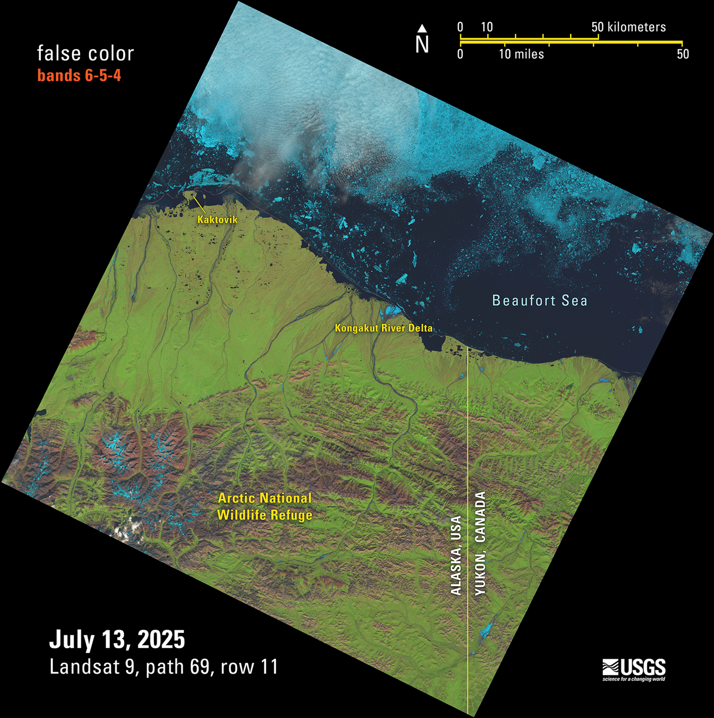
The joint NASA–U.S. Geological Survey (USGS) Landsat program has been a cornerstone of Earth observation for over 50 years. On July 13, Landsat 9 collected its millionth image: a stunning shot of the Arctic National Wildlife Refuge in Alaska – see Figure. Landsat 9, the most recent satellite in the Landsat series, orbits Earth alongside Landsat 8. Together, these satellites collect invaluable data about Earth’s changing land surface every eight days.
Figure: This Landsat 9 image showing the Beaufort Sea shoreline off Alaska and Canada is just one of the scenes captured and processed on July 13, 2025— the same day the USGS EROS archive reached a milestone of one million Landsat 9 Level-1 products. This false color image was made with bands 6, 5, and 4 from the Operational Land Imager. This remote area allows the pristine wilderness environment to support a diverse wildlife and unique ecosystem that includes various species of mammals, birds, and fish. Landsat Level-1 products from Landsat 1 through Landsat 9 can be downloaded at no charge from a number of systems – visit the Landsat Data Access webpage to learn more.
Credit: Public Domain
After collecting more than 3.3 million images over the course of more than 26 years in orbit, Landsat 7 was decommissioned on June 4, 2025. A YouTube video released at the time of decommissioning provides a concise visual summary of the Landsat 7 mission’s achievements – and the technical challenges overcome. In addition, The Earth Observer did a feature for the 20th anniversary of Landsat 7 in the July–August 2019 issue, called “The Living Legacy of Landsat 7: Still Going Strong After 20 Years in Orbit” [Volume 31, Issue 4, pp. 4–14] that is a useful resource to learn more about the history and achievements (through 20 years) of the mission.
One of the strengths of the Landsat program is its potential for data integration with other satellites. The Harmonized Landsat and Sentinel-2 (HLS) product exemplifies this collaborative approach by combining data from Landsat 8 and 9 with data from the European Space Agency’s Copernicus Sentinel-2 A, B, and C missions. Whereas Landsat alone has a repeat time of eight days (i.e., combining Landsat 8 and 9 data); the combined HLS dataset provides imagery for the same location on Earth every 1.6 days – enabling researchers to monitor short-term changes in Earth’s land surface much more effectively than using Landsat or Sentinel-2 data alone.
HLS became one of the most-downloaded NASA data products in fiscal year 2024, with continued growth on the horizon. In February 2025, the program expanded with nine new vegetation indices based on HLS data, with historical processing back to 2013 scheduled for completion by early 2026. Low-latency HLS products will also be available in late 2026. For the full story of how HLS came to be – see the feature: “Harmonized Landsat and Sentinel-2: Collaboration Drives Innovation.”
Following a 13-month hibernation, the Global Ecosystem Dynamics Investigation (GEDI) mission was reinstalled to its original location aboard the ISS and resumed operations on April 22, 2024. Since this storage period, GEDI’s lasers have been operating nominally and the mission has continued to produce high-quality observations of the Earth’s three-dimensional structure, amassing 33 billion land surface returns as of November 27, 2024.
The mission team has been actively processing and releasing post-storage data to the public, with Version 2.1 – GEDI L1B, L2A, L2B, and L4A data products, which include data through November 2024, all available for download. The new L4C footprint-level Waveform Structural Complexity Index (WSCI) product using pre-storage data has also been released. Looking ahead, the team is preparing Version 3.0 (V3) of all data products, which will incorporate post-storage data while improving quality filtering, geolocation accuracy, and algorithm performance.
The 2025 GEDI Science Team Meeting (STM) brought together the mission science team, competed science team, representatives from the distributed active archive centers (DAACs), collaborators, stakeholders, and data users. Notably, it marked the first in-person gathering of the second competed science team, who shared updates on their research projects. The STM held an important space for brainstorming, knowledge-sharing, and discussion as the GEDI mission continues to flourish in its second epoch. To learn more, see “Summary of the 2025 GEDI Science Team Meeting.”
Shifting focus to the boreal forests of North America, the NASA Arctic–Boreal Vulnerability Experiment (ABoVE) is now in its final year, marking the end of a decade-long scientific endeavor that has transformed our understanding of environmental change in Alaska and western Canada. This ambitious campaign, funded primarily by NASA’s Terrestrial Ecology Program, has successfully progressed through three distinct phases: ecosystem dynamics (2015–2018), ecosystem services (2017–2022), and the current analysis and synthesis phase (2023–present).
As ABoVE approaches its conclusion, the program has grown to encompass 67 NASA-funded projects with over 1000 participating researchers – a testament to the collaborative scale required to address complex Arctic–boreal ecosystem questions. The program’s integrated approach, combining field research, airborne campaigns, and satellite remote sensing, has generated unprecedented insights into how environmental changes in these northern regions affect both vulnerable ecosystems and society.
The recent 11th – and final – ABoVE Science Team Meeting was an opportunity to showcase the program’s evolution from data collection to synthesis, highlighting successful community engagement initiatives, cutting-edge research on carbon dynamics and ecosystem responses, and innovative science communication strategies that have made this complex research accessible to diverse audiences. With synthesis activities now underway, ABoVE is positioned to deliver comprehensive insights that will inform Arctic and boreal research for years to come. To learn more, see “Summary of the 11th and Final ABoVE Science Team Meeting.”
Last but certainly not least, I want to both recognize and congratulate Compton J. Tucker [GSFC—Senior Researcher]. Compton retired from NASA in March 2025 after 48 years of public service, and then in April, was among 149 newly elected members to the National Academy of Sciences (NAS) – which is one of the highest honors in American science. This recognition from NAS brings Compton’s career full circle. He came to GSFC as a NAS postdoc before joining NASA as a civil servant. Compton is a pioneer in the field of satellite-based environmental analysis, using data from various Landsat missions and from the National Oceanographic and Atmospheric Administration’s (NOAA) Advanced Very High Resolution Radiometer (AVHRR) instrument. His research has focused on global photosynthesis on land, determining land cover, monitoring droughts and food security, and evaluating ecologically coupled disease outbreaks. The Kudos, “Compton J. Tucker Retires from NASA and is Named NAS Fellow,” provides more details about Compton’s research achievements and all of the other scientific awards and honors received throughout his career.
Barry Lefer Associate Director of Research, Earth Science Division
The NASA Arctic–Boreal Vulnerability Experiment (ABoVE) is a large-scale ecological study in the northern regions of North America (Alaska and western Canada) that was developed to understand environmental changes in the region and the implications of those changes for society. Funded primarily by the NASA Terrestrial Ecology Program, this 10-year campaign has included field, airborne, and satellite remote sensing research to address its overarching scientific question of how environmental change in the Arctic and boreal region of western North America will affect vulnerable ecosystems and society.
ABoVE deployed in three phases: 1) ecosystem dynamics (2015–2018); 2) ecosystem services (2017–2022); and 3) analysis and synthesis (2023–present). Now in the last year of the third phase, the Science Team (ST) consists of 67 active NASA-funded projects with more than 1000 individuals participating. The ABoVE ST has met yearly to discuss the progress of individual teams, plan joint field work, and discuss synthesis activities. ABoVE was featured in a 2019 The Earth Observer article, titled “Summary of the 2019 ABoVE Science Team Meeting” [July–August 2019, Volume 31, Issue 4, pp. 19–22], as well as a 2022 The Earth Observer article, titled “Summary of the Eighth ABoVE Science Team Meeting” [September–October 2022, Volume 34, Issue 5, pp. 28–33].
Meeting Overview
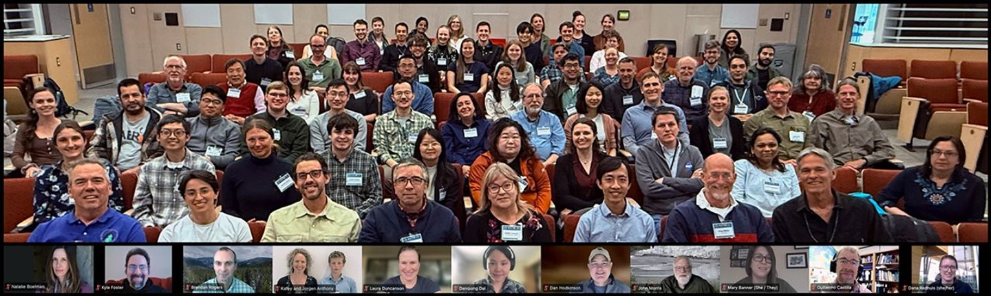
The 11th – and final – ABoVE Science Team Meeting (ASTM11) was held May 12–15, 2025, with 96 registered in-person attendees meeting at the University of Alaska, Fairbanks (UAF) and 67 registered virtual attendees – see Photo 1. The meeting included presentations from Phase 3 projects and synthesis reports from thematic working groups (WGs). ABoVE partners, including collaborators [e.g., the Department of Energy’s Next Generation Ecosystem Experiment-Arctic (NGEE-Arctic), Polar Knowledge Canada (POLAR), the Canadian Forest Service (CFS), and the Government of the Northwest Territories (GNWT)] and representatives from upcoming NASA campaigns focusing on the Arctic, shared updates on their activities. Additionally, the meeting featured sessions highlighting cross-project activities, e.g., ABoVE’s participation in regional fire workshops. The meeting also focused on collaborations with the Scotty Creek Research Station in Canada, the many types of science communication activities during ABoVE, and projects conducting collaborative research with community or regional partners.
Photo 1.The 11th Arctic–Boreal Vulnerability Experiment Science Team (ABoVE) meeting group photo of in-person and virtual participants.
Photo credit: Peter Griffith, Leane Kending, and David Stroud
The meeting included additional team activities designed to encourage collaboration and understanding between team members. There were opportunities for multiple field trips for in-person attendees, including visits to the Alaska Satellite Facility (ASF) at the Geophysical Institute, the Permafrost Tunnel operated by the Cold Regions Research and Engineering Laboratory (CRREL), the Yankovich Road Fire Interpretive Trail, and the Arctic Research Open House at UAF – see ABove Field Trips section to learn more. The meeting offered early career researchers a chance to receive feedback on their posters and participate in an Early Career lunch event. The meeting even hosted an ABoVE bingo competition, which encouraged attendees to make new scientific and social connections – see Photo 2.
Photo 2. Scott Goetz [University of Northern Arizona—ABoVE Science Team Lead] poses with ABoVE BINGO winner Wanwan Liang [University of Utah].
Photo credit: Wanwan Liang
Meeting Opening
The first day of the meeting began with a series of opening remarks from the ABoVE leadership team. Peter Griffith [NASA’s Goddard Space Flight Center (GSFC)/Science Systems and Applications, Inc. (SSAI)—Chief Scientist, Carbon Cycle and Ecosystems Office (CCEO)], Scott Goetz [Northern Arizona University (NAU)—ABoVE ST Lead], and Ryan Pavlick [NASA Headquarters (HQ)—ABoVE Program Manager] all noted the significance of this final meeting and discussed the major scientific advances of ABoVE made possible through the dedication of ST members, WG leads, planning committees, and contributors who have made ABoVE a success. Goetz reviewed the meeting goals and objectives:
receive updates about currently funded projects;
receive reports on Thematic WG advances with an emphasis on multiple WG and cross-phase synthesis activities;
receive updates on research connections with partners and collaborators;
discuss, reflect, and document the history of ABoVE, including major advances, lessons learned, and items to accomplish in the time remaining; and
celebrate ABoVE success stories, with advice for potential future NASA large-scale coordinated campaigns.
Working Group Presentations and Breakouts
Throughout the first few days of the meeting, leads for the thematic working groups (WG) presented synthetic overviews of the research efforts of their group members, identified current gaps in planned or completed research, and discussed potential future work. Following these presentations, breakout groups convened to discuss future activities of the WGs. Short summaries of each presentation are available below. Together, these presentations demonstrate the highly interconnected nature of carbon cycles, hydrology, permafrost dynamics, and disturbance regimes in Arctic–boreal ecosystems. The presentations also showcase the substantial ongoing WG efforts to synthesize findings and identify critical knowledge gaps for future research priorities.
Vegetation Dynamics Working Group
WG Leads: Matthew Macander [Alaska Biological Research, Inc. (ABR)] and Paul Montesano [GSFC/ADNET Systems Inc.]
The Vegetation Dynamics WG discussed new advances in understanding Arctic–boreal vegetation structure and function that have been made over the past 10 years through comprehensive biomass maps and multidecadal trend analyses. ABoVE research revealed a critical boreal forest biome shift with greening in nitrogen-rich northern forests and browning in drought-stressed southern forests. The group has identified key knowledge gaps in predicting post-fire vegetation recovery and detecting pervasive declines in vegetation resilience across southern boreal forests. The results suggest higher vulnerability to abrupt forest loss that could dampen the expected increase in carbon sequestration under future climate scenarios.
Over the past year, the Spectral Imaging WG focused on the fundamental scale problem in Arctic ecology, which refers to the mismatch between observation scales and ecological process scales, which span spatial scales from leaf level to larger study areas and temporal scales from minutes to decades. The Airborne Visible/Infrared Imaging Spectrometer – Next Generation (AVIRIS-NG) and AVIRIS-3 datasets provide the first broad-area and high-spatial and spectral resolution coverage of high-latitude terrestrial ecosystems. The WG is now completing a scaling synthesis paper and preparing for the new era of data-rich spectral imaging with improved capabilities in data management, machine learning, and modeling applications for high-latitude research.
Modeling Working Group
WG Lead: Josh Fisher [Chapman University]
The Modeling WG aims to reduce model uncertainties in simulations and projections in the Arctic–boreal region across all ABoVE ecosystem indicators. The WG had polled the ST to determine the variables most needed for their Earth system models and is now using the field, airborne, and satellite datasets to better constrain these models. This WG discussed the benefits to the modeling community of transforming the more than 100 ABoVE datasets into a common grid and projection format used by modelers.
The Carbon Dynamics WG has focused its recent work on three areas: decadal syntheses of carbon dioxide (CO2) fluxes from eddy covariance towers, machine learning approaches to upscaling wetland and lake methane (CH4) emissions, and carbon flux modeling across the Arctic–boreal zone. The research integrated atmospheric CO2 observations to improve carbon flux estimates and examined wildfire impacts on both carbon emissions and albedo changes. A significant component of the work involved comparing top-down versus bottom-up carbon flux models, with particular attention to permafrost and peatland regions.
Hydrology-Permafrost-Wetlands Working Group
WG Leads: Laura Bourgeau-Chavez [Michigan Technological University], David Butman [University of Washington], John Kimball [University of Montana], and Melissa Schwab [University of California, Irvine]
WG Leads: Dong Chen [University of Maryland, College Park] and Jinhyuk Kim [University of California, Irvine]
The Disturbance WG leads presented their decade-long perspective on disturbance-related research in the ABoVE domain. The presentation incorporated artificial intelligence (AI)-generated summaries of ABoVE-affiliated research across multiple disturbance types, including boreal wildfires, tundra wildfires, and thermokarst/permafrost degradation processes. Chen and Kim acknowledged the extensive contributions from researchers and WG members while outlining future directions for disturbance research.
Success Stories
Four “Success Story” presentations and panels took place during ASTM11, which showcased efforts of ABoVE ST members and the leadership team to create and coordinate engagement efforts that spanned individual projects.
Success Story 1: ABoVE Participation in Regional Fire Workshops
A substantial portion of ABoVE research has focused on wildfire, and many members of the ST have participated in domestic and international wildfire efforts, connecting researchers with land managers across Alaska and Canada. Randi Jandt [UAF] discussed the Alaska Fire Science Consortium workshops (held in 2017 and 2022). Jenn Baltzer [Wilfred Laurier University (WLU), Canada] discussed Northwest Territories workshops (held in 2014 and 2025), both of which occurred in response to extreme fire seasons in the region. Laura Bourgeau-Chavez outlined ABoVE’s participation in all of these workshops. The workshops facilitated knowledge exchange and collaboration on critical wildfire management priorities, including fire risk assessment, real-time modeling, post-fire effects, and climate change impacts on fire regimes. Key features included small focus groups, field trips to command centers and fire-affected areas, and integration of Indigenous knowledge with new technologies to inform management practices and climate preparedness strategies.
Success Story 2: Collaborations with Scotty Creek Research Station (SCRS)
ASTM11 participants watched the film, “Scotty Creek Research Community – The Spirit of Collaboration,” about the SCRS, Canada’s first and only Indigenous-led research station. Following the film, station team members participated in a panel discussion. Ramona Pearson [Ramona Pearson Consulting, Canada], Maude Auclair [WLU], Mason Dominico [WLU], Michael McPhee [Sambaa K’e First Nation, Canada], and William “Bill” Quinton [WLU] discussed their decade-long collaboration with ABoVE. The partnership involved ABoVE collecting airborne hyperspectral, lidar, and radar imagery, while SCRS researchers provided field data for calibration and validation. In 2022, management of the station transitioned to Łı́ı́dlı̨ı̨ Kų́ę́ First Nation (LKFN, Canada), and ABoVE continued collaborating through knowledge exchange, including with early-career researchers and interns. When a 2022 fire destroyed the field station and surrounding area, ABoVE flew additional flights to capture airborne imagery observations to allow comparison of pre- and post-fire conditions.
Success Story 3: Science Communication
During the ABoVE field campaign, ST members and CCEO staff engaged in multiple strategies to communicate research results to the public. The activities included interactive engagement through airborne open houses and guest flights, ST member narratives in the “Notes from the Field” blog posts on the NASA Earth Observatory website, and professional multimedia production, including Earth Observatory content and award-winning videos. This multifaceted strategy demonstrates effective scientific communication through direct public engagement and high-quality, multimedia storytelling, making complex research accessible to diverse audiences.
Success Story 4: Engagement Activities
This session highlighted several examples of community engagement across the ABoVE domain. Gerald “J.J.” Frost [ABR] discussed synthesizing ecosystem responses and elder observations in western Alaska for his ABoVE project. In another example, ABoVE researchers from Michigan Tech Research Institute (MTRI) partnered with Ducks Unlimited Canada (DUC) and local organizations. Dana Redhuis [MTRI] and Rebecca Edwards [DUC] described their on-the-land camps that provide hands-on training for Northwest Territories youth in wetlands education and ecological monitoring. Kevin Turner [Brock University, Canada] showcased his work with members of the Vuntut Gwitchin First Nation in Old Crow Flats, Yukon, evaluating how climate and land cover change influence water dynamics and carbon balance. These activities demonstrate collaborative research that integrates Indigenous and Western knowledge approaches to address climate change impacts.
ABoVE Phase 3 Project Presentations
Project leads of the 20 NASA-funded ABoVE Phase 3 projects presented updates that were organized by scientific theme. The presentations spanned multiple days of the meeting. Table 1 below provides all the project titles, presenter names, and links to each project and presentation. Science results from four of the presentations are shown in Figures 1–4 below as indicated in the table.
Table 1. An overview ofABoVE Phase 3 projects and presenters. The Project name includes the last name of the Principal Investigator, NASA funding program (TE for Terrestrial Ecology), the year of the NASA solicitation funding the research, and provides a hyperlink to the Project Profile. A hyperlink to each presentation is provided as either PowerPoint (PPT) file or PDF.
Project
Carbon
Presenter(s)
Bloom (TE 2021): Using CO2, CH4 and land-surface constraints to resolve sign and magnitude of northern high latitude carbon-climate feedbacks [PDF]
Eren Bilir [NASA/Jet Propulsion Laboratory (JPL)]; Principal Investigator (PI): Alexis (Anthony) Bloom [NASA/Jet Propulsion Laboratory (JPL)]
Butman (TE 2021): Do changing terrestrial-aquatic interfaces in Arctic-boreal landscapes control the form, processing, and fluxes of carbon? [PPT]
David Butman [University of Washington] – see Figure 1
Watts (TE 2021): Contributions of tundra and boreal systems to radiative forcing in North America and Russia under contemporary and future conditions [PPT]
Jennifer Watts [Woodwell Climate Research Center]
Miller-S (TE 2021): A synthesis and reconciliation of greenhouse gas flux estimates across the ABoVE domain [PDF]
Scot Miller [Johns Hopkins University]
Michalak (TE 2021): Quantifying climate sensitivities of photosynthesis and respiration in Arctic and boreal ecosystems from top-down observational constraints [PDF]
Wu Sun and Jiaming Wen [both Carnegie Institution for Science, CI]; PI: Anna Michalak, [Carnegie Institution for Science]
Fire
Presenter(s)
Bourgeau-Chavez (TE 2021): Integrating remote sensing and modeling to better understand the vulnerability of boreal-taiga ecosystems to wildfire [PPT]
Laura Bourgeau-Chavez [Michigan Technological University (MTU)]
Walker (TE 2021): Drivers and Impacts of Reburning in boreal forest Ecosystems (DIRE) [PDF]
Jeremy Forsythe [Northern Arizona University (NAU)]; PI: Xanthe Walker [NAU]
Wang (TE 2021): Quantifying disturbance and global change impacts on multi-decadal trends in aboveground biomass and land cover across Arctic-boreal North America [PPT]
Jonathan Wang [University of Utah]– see Figure 2
Wildlife
Presenter(s)
Boelman (TE 2021): The future of the Forest-Tundra Ecotone: A synthesis that adds interactions among snow, vegetation, and wildlife to the equation [PPT]
Natalie Boelman [Lamont-Doherty Earth Observatory, Columbia University]
French (TE 2021): Informing wetland policy and management for waterfowl habitat and other ecosystem services using multi-frequency synthetic aperture radar [PPT]
Nancy French [MTU] – see Figure 3
Hydrology / Permafrost
Presenter(s)
Du (TE 2021): High resolution mapping of surface soil freeze thaw status and active layer thickness for improving the understanding of permafrost dynamics and vulnerability [PPT]
Jinyang Du [University of Montana]
Miller (TE 2021): Enhanced methane emissions in transitional permafrost environments: An ABoVE phase 3 synthesis investigation [PPT]
Charles “Chip” Miller [NASA/JPL]
Tape (TE 2021): Characterizing a widespread disturbance regime in the ABoVE domain: Beaver engineering [PPT]
Kenneth Tape [University of Alaska, Fairbanks]
Zhuang (TE 2021): Role of linked hydrological, permafrost, ground ice, and land cover changes in regional carbon balance across boreal and Arctic landscapes [PDF]
Qianlai Zhuang [Purdue University]
Vegetation Structure
Presenter(s)
Duncanson (TE 2021): Mapping boreal forest biomass recovery rates across gradients of vegetation structure and environmental change [PPT]
Paul Montesano [GSFC/ADNET Systems Inc]; PI: Laura Duncanson [University of Maryland]—see Figure 4
Lara (TE 2021): ABoVE-Ground characterization of plant species succession in retrogressive thaw slumps using imaging spectroscopy [PPT]
Mark Lara [University of Illinois, Urbana-Champaign]
Vegetation Dynamics
Presenter(s)
Frost (TE 2021): Towards a warmer, less frozen future Arctic: Synthesis of drivers, ecosystem responses, and elder observations along bioclimatic gradients in western Alaska [PPT]
Gerald “J.J.” Frost [ABR]
Goetz (TE 2021): Mapping and modeling attributes of an Arctic-boreal biome shift: Phase-3 applications within the ABoVE domain [PPT]
Scott Goetz [NAU]
Liu (TE 2021): Characterizing Arctic-boreal vegetation resilience under climate change and disturbances [PPT]
Yanlan Liu [The Ohio State University]
Townsend (TE 2021): Functional diversity as a driver of gross primary productivity variation across the ABoVE domain [PPT]
Philip Townsend [University of Wisconsin]
Determining Aboveground Biomass Density Using ICESat-2 Data and Modeling
Figure 1. Despite their relatively small coverage, surface water extent across boreal and arctic lowlands significantly impacts landscape-scale estimates of carbon emissions. The red points on the map in the figure indicates locations of available lake chemistry data derived from ABoVE-supported research, from collaborators, and from a preliminary literature search.
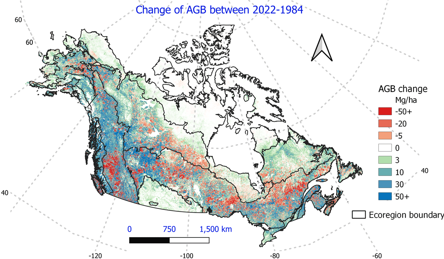
Figure 2. The Arctic-boreal carbon cycle is inextricably linked to vegetation composition and demography, both of which are being altered by climate change, rising levels of atmospheric carbon dioxide, and climate-induced changes in disturbance regimes. The map in the figure shows above-ground biomass (AGB) change across Arctic-boreal North America (2022–1984) created using a machine learning model of AGB trained on from more than 45,000 field plots and 200,000 km2 of airborne lidar data.
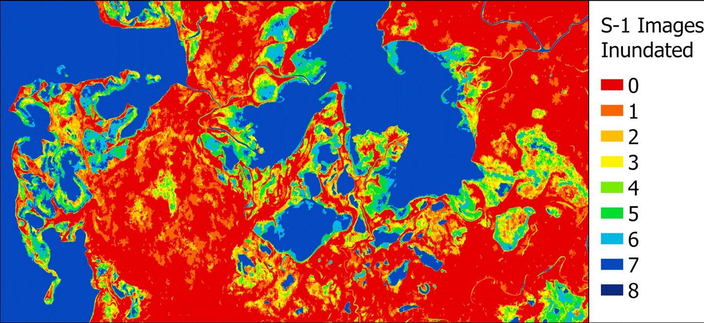
Figure 3. Wetlands provide many ecosystem services, including waterfowl habitat, carbon sequestration, and water quality. Northern wetlands Iin the ABovE study area) are threatened from both land use expansion and climate change disruptions, prompting the need for informed management strategies. Copernicus Sentinel 1 synthetic aperture radar (SAR) data have been used to create this map of flooding (hydroperiod) in wetland areas around the Great Slave Lake in Canada The color code on the map corresponds to the number of times the SAR imagery indicated a place was flooded (inundated). Such information is helpful for predicting within-season changes in wetland extent.
Figure 4. Advances have been made in mapping aboveground biomass density (AGBD). Shown here as an example is an AGBD map created using stata from the ICESat-2pan-Boreal 30-m (98-ft) tree height and biomass data product [left] and the ensemble mean of the standard deviation of AGBD, aggregated to modelling tiles [right]. Current research aims to expand these maps and understand regional vegetation changes.
ASTM11 featured 41 research posters across three sessions, organized by thematic area – see Table 3 and Photo 3. The Poster Session agenda details the range of topics that spanned airborne synthetic aperture radar (SAR) and satellite imagery to northern ecosystem fieldwork. Key research topics that emerged included CO2 and CH4 emissions from terrestrial and aquatic systems, ongoing permafrost thaw, fire impacts on carbon cycling, vegetation mapping and biomass estimation, and the impacts of wildlife on the landscape.
Table 2. A breakdown of ASTM11 poster presentations by science theme.
Poster Theme
Poster Count
Carbon Dynamics
5
Crosscutting, Modeling, or Other
6
Fire Disturbance
5
Permafrost, Hydrology, and Wetlands
13
Vegetation Dynamics and Distribution
7
Vegetation Structure and Function
4
Wildlife and Ecosystem Services
1
Photo 3. Poster presentations and sessions during ASTM11 offered opportunities for presenters to share their latest research findings with meeting participants.
Photo credit: Elizabeth Hoy
ABoVE Field Trips
ASTM11 offered multiple field trip options across the Fairbanks region of Alaska. The fieldtrips provided ST members an opportunity to interact with the research community – see Photo 4.
Trip to Alaska Satellite Facility (ASF) and Geophysical Institute ASF is a data archive for many SAR datasets from a variety of sensors and has multiple ground station facilities. During the tour, participants visited the ASF operations room and ASF rooftop antenna. The Geophysical Institute tour also featured the Alaska Earthquake Center, Wilson Alaska Technical Center, and Alaska Center for Unmanned Aircraft Systems Integration.
Trip to Cold Regions Research and Engineering Laboratory (CRREL) Permafrost Tunnel The U.S. Army Core of Engineers CRREL Permafrost Tunnel is located in Fox, AK – about 15 km (9 mi) north of Fairbanks. Over 300 m (984 ft) of tunnel have been excavated, exposing Pleistocene ice and carbon-rich yedoma permafrost that ranges in age from 18,000 to 43,000 years old. The tunnel exposes mammoth and bison bones and a variety of permafrost soils. Ongoing projects in the tunnel cover a range of topics, including engineering and geophysical work, Mars analog studies, and biogeochemistry and microbiology of permafrost soils.
Wildfire Walk: Yankovich Road Fire Interpretive Trail On July 11, 2021, a wildfire burned 3.5 acres (14,164 m2) of UAF land. In 2024, the UAF Alaska Fire Science Consortium, Bureau of Land Management Alaska Fire Service, and local artist Klara Maisch collaborated with others to develop the Wildfire Walk at the site. The interpretive trail is an outdoor learning experience with interpretive wayside markers that describe the fire incident, the relationship between wildfire and the boreal forest, fire science and environmental change, and wildfire prevention – see Figure 1.
UAF Arctic Research Open House The UAF Arctic Research Open House was an opportunity for ST members and the public to explore the wide range of research happening at UAF and meet other scientists. ABoVE hosted an information table at the event.
Photo 4: Collage of images collected during a series of field trips, including [top] the Wildfire Walk along the Alaska Fire Science Consortium, [middle] the Permafrost Tunnel with Tom Douglas [Cold Regions Research and Engineering Laboratory], [bottom left] UAF Arctic Open House ABoVE Table with Margaret “Maggie” Wooton [NASA’s Goddard Space Flight Center (GSFC)/Science System and Applications, Inc. (GSFC/SSAI)], Elizabeth Hoy [GSFC/Global Science & Technology Inc.], and Qiang Zhou [GSFC/SSAI], talking with Logan Berner [Northern Arizona University], [bottom right] the Alaska Satellite Facility ground receiving antenna.
Photo credit: Elizabeth Hoy
Research Connections
The success of ABoVE as a large-scale research study over the Arctic and boreal regions within and outside the United States depended on collaboration with multiple organizations. Many of the ABoVE collaborators were able to present at ASTM11.
Andrew Applejohn [Polar Knowledge Canada (POLAR)] provided details about the scope, mandate, and facilities available through POLAR, a Canadian government agency that has partnered with the ABoVE ST for the duration of the campaign.
Ryan Connon [Government of the Northwest Territories (GNWT)] discussed the decade-long collaboration between ABoVE and the GNWT, including knowledge sharing of wildlife collar data, field-data ground measurements, and remote sensing analyses.
Gabrielle Gascon [Canadian Forest Service (CFS), Natural Resources Canada] explained the scope of Canada’s National Forest Inventory and the current CFS focus on wildfire and the CFS’s other areas of research related to the northern regions. Another presentation featured information about various vegetation mapping initiatives where Matthew Macander discussed an Alaska-based effort called AKVEG Map, a vegetation plot database, and Logan Berner [NAU] detailed a pan-Arctic plant aboveground biomass synthesis dataset.
Brendan Rogers [WCRC] showcased research from Permafrost Pathways, designed to bring together permafrost-related science experts with local communities to inform Arctic policy and develop adaptation and mitigation strategies to address permafrost thaw. NGEE-Arctic is another U.S. government effort that partnered specifically with ABoVE for the duration of the two efforts, and Bob Bolton [Oak Ridge National Laboratory (ORNL)] provided updates on the project.
Tomoko Tanabe [Japan’s National Institute of Polar Research (JNIPR)] gave a presentation about NIPR to better inform ABoVE scientists about other international Arctic efforts, including a new Japanese Arctic research initiative called the Arctic Challenge for Sustainability III (ArCS III), designed to address social issues related to environmental and social changes in the Arctic.
Additional Presentations
An additional presentation aimed to keep the ABoVE ST informed of future NASA Arctic research efforts. Kelsey Bisson [NASA HQ—Program Scientist for the Ocean Biology and Biogeochemistry Program] discussed NASA Arctic-COLORS and Maria Tzortziou [City University of New York/Columbia University, LDEO] discussed the FORTE EVS campaign. The proposed Arctic-COLORS field campaign would quantify the biogeochemical and ecological response of Arctic nearshore systems to rapid changes in terrestrial fluxes and ice conditions. The NASA FORTE EVS campaign will fill a critical gap in understanding Alaska’s northernmost ecosystems by investigating eroding coastlines, rivers, deltas, and estuaries that connect land and sea systems, using airborne platforms.
Scott Goetz continued with a presentation on U.S. efforts to plan the International Polar Year, scheduled for 2032–2033. Ryan Pavlick provided details on the NISAR mission, which launched after the meeting on July 30, 2025, and discussed other possible future NASA missions.
A Career Trajectory panel featured Jennifer Watts, Jonathan Wang, Brendan Rogers, and Xiaoran “Seamore” Zhu [Boston University]. The panelists discussed opportunities for researchers from different academic backgrounds and at different career stages, and they provided details about how ABoVE has impacted their careers. They also discussed how NASA campaigns offer opportunities for early career scientists to join a team of peers to grow their abilities throughout the duration of the decade-long research.
Klara Maisch, a local artist, discussed her work creating science-informed artwork through interdisciplinary collaborations with scientists and other creators – see Figure 5. Maisch described the benefits of partnering with artists to share science with a broad audience and showcased artwork she has created.
Figure 5. Lower Tanana Homelands – 2022 Yankovich Fire – Plot Painting [left], with original plot reference photograph [right].
Image Credit: Klara Maisch
Overarching Presentations
A series of presentations on the overall structure and outcomes of ABoVE were held during ASTM11. Charles “Chip” Miller [NASA/JPL—Deputy ABoVE ST Lead, ABoVE Airborne Lead] provided details about SAR, hyperspectral, and lidar airborne measurements collected between 2017 and 2024 for the ABoVE Airborne Campaign.
ABoVE Logistics Office members Daniel Hodkinson [GSFC/SSAI], Sarah Dutton [GSFC/SSAI], and Leanne Kendig [GSFC/Global Science & Technology, Inc. (GST, Inc.)] discussed the many field teams and activities supported during ABoVE. Overall, more than 50 teams were trained in field safety topics, with more than 1,200 training certificates awarded. Elizabeth Hoy [NASA GSFC/GST, Inc.] and Debjani Singh [ORNL] discussed the more than 250 data products developed during the ABoVE program and how to access them through NASA Earthdata. Example visualizations of ABoVE data products can be found in Figure 6.
The Collaborations and Engagement WG held a plenary discussion to highlight the many activities that ABoVE researchers have been involved in over the past decade. The discussion highlighted the need for individual projects and campaign leadership to work together to ensure participation and understanding of planned research at local and regional levels.
A highlight of the meeting was the “Legacy of ABoVE” panel discussion moderated by Nancy French [MTU]. Panelists included Eric Kasischke [MTU], Scott Goetz, Chip Miller, Peter Griffith, Libby Larson [NASA GSFC/SSAI], and Elizabeth Hoy. Each panelist reflected on their journey to develop ABoVE, which included an initial scoping study developed more than 15 years ago. Members of the panel – all a part of the ABoVE leadership team – joined the campaign at different stages of their career. Each panelist arrived with different backgrounds, bringing their unique perspective to the group that helped to frame the overall campaign development. Following the panel, all ST members who have been a part of ABoVE since its start over a decade ago came to the front for a group photo – see Photo 5.
Following the panel, the ABoVE ST leads presented their overall thoughts on the meeting and facilitated a discussion with all participants at the meeting. Participants noted the important scientific discoveries made during ABoVE and enjoyed the collegial atmosphere during ASTM11.
Photo 5. A group photo of participants who have been with ABoVE since its inception: [left to right] Ryan Pavlick, Chip Miller, Elizabeth Hoy, Libby Larson, Peter Griffith, Fred Huemmrich, Nancy French, Scott Goetz, Laura Bourgeau-Chavez, Eric Kasischke, and Larry Hinzman.
Photo credit: Peter Griffith
Conclusion
Overall, ASTM11 brought together an interdisciplinary team for a final team meeting that showcased the many accomplishments made over the past decade. The group outlined current gaps and needs in Arctic and boreal research and discussed possibilities for future NASA terrestrial ecology campaigns. The synthesis science presentations at ASTM11 highlighted the advances ABoVE has made in understanding carbon and ecosystem dynamics in Arctic and boreal regions. It also highlighted the need for further study of cold season and subsurface processes. While this was the last meeting of this ST, research for some projects will continue into 2026, and more publications and data products are expected from ST members in the near term.
Elizabeth Hoy NASA’s Goddard Space Flight Center/Global Science & Technology Inc. (GSFC/GST,Inc.) elizabeth.hoy@nasa.gov
Libby Larson NASA’s Goddard Space Flight Center/Science System and Applications, Inc. (GSFC/SSAI) libby.larson@nasa.gov
Annabelle Sokolowski NASA GSFC Office of STEM Engagement (OSTEM) Intern
Caitlin LaNeve NASA GSFC Office of STEM Engagement (OSTEM) Intern
This animation depicts water disappearing over time in the Martian river valley Neretva Vallis, where NASA’s Perseverance Mars takes the rock sample named “Sapphire Canyon” from a rock called “Cheyava Falls,” which was found in the “Bright Angel” formation. Credit: NASA
A sample collected by NASA’s Perseverance Mars rover from an ancient dry riverbed in Jezero Crater could preserve evidence of ancient microbial life. Taken from a rock named “Cheyava Falls” last year, the sample, called “Sapphire Canyon,” contains potential biosignatures, according to a paper published Wednesday in the journal Nature.
A potential biosignature is a substance or structure that might have a biological origin but requires more data or further study before a conclusion can be reached about the absence or presence of life.
“This finding by Perseverance, launched under President Trump in his first term, is the closest we have ever come to discovering life on Mars. The identification of a potential biosignature on the Red Planet is a groundbreaking discovery, and one that will advance our understanding of Mars,” said acting NASA Administrator Sean Duffy. “NASA’s commitment to conducting Gold Standard Science will continue as we pursue our goal of putting American boots on Mars’ rocky soil.”
NASA’s Perseverance rover discovered leopard spots on a reddish rock nicknamed “Cheyava Falls” in Mars’ Jezero Crater in July 2024. Scientists think the spots may indicate that, billions of years ago, the chemical reactions in this rock could have supported microbial life; other explanations are being considered.
Credit: NASA/JPL-Caltech/MSSS
NASA’s Perseverance Mars rover took this selfie, made up of 62 individual images, on July 23, 2024. A rock nicknamed “Cheyava Falls,” which has features that may bear on the question of whether the Red Planet was long ago home to microscopic life, is to the left of the rover near the center of the image.
Credit: NASA/JPL-Caltech/MSSS
Perseverance came upon Cheyava Falls in July 2024 while exploring the “Bright Angel” formation, a set of rocky outcrops on the northern and southern edges of Neretva Vallis, an ancient river valley measuring a quarter-mile (400 meters) wide that was carved by water rushing into Jezero Crater long ago.
“This finding is the direct result of NASA’s effort to strategically plan, develop, and execute a mission able to deliver exactly this type of science — the identification of a potential biosignature on Mars,” said Nicky Fox, associate administrator, Science Mission Directorate at NASA Headquarters in Washington. “With the publication of this peer-reviewed result, NASA makes this data available to the wider science community for further study to confirm or refute its biological potential.”
The rover’s science instruments found that the formation’s sedimentary rocks are composed of clay and silt, which, on Earth, are excellent preservers of past microbial life. They also are rich in organic carbon, sulfur, oxidized iron (rust), and phosphorous.
“The combination of chemical compounds we found in the Bright Angel formation could have been a rich source of energy for microbial metabolisms,” said Perseverance scientist Joel Hurowitz of Stony Brook University, New York and lead author of the paper. “But just because we saw all these compelling chemical signatures in the data didn’t mean we had a potential biosignature. We needed to analyze what that data could mean.”
First to collect data on this rock were Perseverance’s PIXL (Planetary Instrument for X-ray Lithochemistry) and SHERLOC (Scanning Habitable Environments with Raman & Luminescence for Organics & Chemicals) instruments. While investigating Cheyava Falls, an arrowhead-shaped rock measuring 3.2 feet by 2 feet (1 meter by 0.6 meters), they found what appeared to be colorful spots. The spots on the rock could have been left behind by microbial life if it had used the raw ingredients, the organic carbon, sulfur, and phosphorus, in the rock as an energy source.
In higher-resolution images, the instruments found a distinct pattern of minerals arranged into reaction fronts (points of contact where chemical and physical reactions occur) the team called leopard spots. The spots carried the signature of two iron-rich minerals: vivianite (hydrated iron phosphate) and greigite (iron sulfide). Vivianite is frequently found on Earth in sediments, peat bogs, and around decaying organic matter. Similarly, certain forms of microbial life on Earth can produce greigite.
The combination of these minerals, which appear to have formed by electron-transfer reactions between the sediment and organic matter, is a potential fingerprint for microbial life, which would use these reactions to produce energy for growth. The minerals also can be generated abiotically, or without the presence of life. Hence, there are ways to produce them without biological reactions, including sustained high temperatures, acidic conditions, and binding by organic compounds. However, the rocks at Bright Angel do not show evidence that they experienced high temperatures or acidic conditions, and it is unknown whether the organic compounds present would’ve been capable of catalyzing the reaction at low temperatures.
The discovery was particularly surprising because it involves some of the youngest sedimentary rocks the mission has investigated. An earlier hypothesis assumed signs of ancient life would be confined to older rock formations. This finding suggests that Mars could have been habitable for a longer period or later in the planet’s history than previously thought, and that older rocks also might hold signs of life that are simply harder to detect.
“Astrobiological claims, particularly those related to the potential discovery of past extraterrestrial life, require extraordinary evidence,” said Katie Stack Morgan, Perseverance’s project scientist at NASA’s Jet Propulsion Laboratory in Southern California. “Getting such a significant finding as a potential biosignature on Mars into a peer-reviewed publication is a crucial step in the scientific process because it ensures the rigor, validity, and significance of our results. And while abiotic explanations for what we see at Bright Angel are less likely given the paper’s findings, we cannot rule them out.”
The scientific community uses tools and frameworks like the CoLD scale and Standards of Evidence to assess whether data related to the search for life actually answers the question, Are we alone? Such tools help improve understanding of how much confidence to place in data suggesting a possible signal of life found outside our own planet.
Marked by seven benchmarks, the Confidence of Life Detection, or CoLD, scale outlines a progression in confidence that a set of observations stands as evidence of life.
Credit: NASA
Sapphire Canyon is one of 27 rock cores the rover has collected since landing at Jezero Crater in February 2021. Among the suite of science instruments is a weather station that provides environmental information for future human missions, as well as swatches of spacesuit material so that NASA can study how it fares on Mars.
Managed for NASA by Caltech, NASA JPL built and manages operations of the Perseverance rover on behalf of the agency’s Science Mission Directorate as part of NASA’s Mars Exploration Program portfolio.
Preparations for Next Moonwalk Simulations Underway (and Underwater)
While auroras are a beautiful sight on Earth, the solar activity that causes them can wreak havoc with space-based infrastructure like satellites. Using artificial intelligence to predict these disruptive solar events was a focus of KX’s work with FDL.
Credit: Sebastian Saarloos
In the summer of 2024, people across North America were amazed when auroras lit up the night sky across their hometowns, but the same solar activity that makes auroras can cause disruptions to satellites that are essential to systems on Earth. The solution to predicting these solar events and warning satellite operators may come through artificial intelligence.
The Frontier Development Lab of Mountain View, California, is an ongoing partnership between NASA and commercial AI firms to apply advanced machine learning to problems that matter to the agency and beyond. Since 2016, the Frontier Development Lab has applied AI on behalf of NASA in planetary defense, Heliophysics, Earth science, medicine, and lunar exploration.
Through a collaboration with a company called KX Systems, the Frontier Development Lab looked to use proven software in an innovative new way. The company’s flagship data analytics software, called kdb+, is typically used in the financial industry to keep track of rapid shifts in market trends, but the company was exploring how it could be used in space.
Between 2017 and 2019, KX Systems participated in the Frontier Development Lab partnership through NASA’s Ames Research Center in Silicon Valley, California. Working with NASA scientists, KX applied the capabilities of kdb+ to searching for exoplanets and predicting space weather, areas which could be improved with AI models. One question the Frontier Development Lab worked to answer was whether kdb+ could forecast the kind of space weather that creates the auroras to predict when GPS satellites might experience signal interruption due to the Sun.
By importing several datasets monitoring the ionosphere, solar activity, and Earth’s magnetic field, then applying machine learning algorithms to them, the Frontier Development Lab researchers were able to predict disruptive events up to 24 hours in advance.
While this was a scientific application of AI, KX Systems says some of this development work has made it back into its commercial offerings, as there are similarities between AI models developed to find patterns in satellite signal losses and ones that predict maintenance needs for industrial manufacturing equipment.
A division of FD Technologies plc., KX Systems is a technology company that offers database management and analytics software for customers that need to make decisions quickly. While KX started in 1993, its AI-driven business has grown considerably, and the company credits work done with NASA for accelerating some of its capabilities.
From protecting valuable satellites to keeping manufacturing lines moving at top performance, pairing NASA’s expertise with commercial ingenuity is a combination for success.
The Artemis II crew (from front left to back right) – pilot Victor Glover, commander Reid Wiseman, mission specialist Jeremy Hansen of CSA (Canadian Space Agency), and mission specialist Christina Koch – walk out of the Neil A. Armstrong Operations and Checkout Building at NASA’s Kennedy Space Center in Florida on Monday, Aug. 11, 2025.
Join the Artemis II mission and sign up to launch your name aboard the Orion spacecraft and SLS (Space Launch System) rocket alongside the crew.
Through the Artemis program, NASA will send astronauts to explore the Moon for scientific discovery, economic benefits, and to build the foundation for the first crewed missions to Mars – for the benefit of all.
Research Astrophysicist and Roman’s Deputy Wide Field Instrument Scientist – Goddard Space Flight Center
From a young age, Ami Choi — now a research astrophysicist at NASA — was drawn to the vast and mysterious. By the fifth grade, she had narrowed her sights to two career paths: marine biology or astrophysics.
“I’ve always been interested in exploring big unknown realms, and things that aren’t quite tangible,” Choi said. That curiosity has served her all throughout her career.
In addition to conducting research, Ami Choi shares science with the public at various outreach events, including tours at NASA’s Goddard Space Flight Center in Greenbelt, Md. This photo captures one tour stop, outside the largest clean room at Goddard.
Credit: NASA/Travis Wohlrab
As a student at University Laboratory High School in Urbana, Illinois, Choi gravitated toward astrophysics and was fascinated by things like black holes. She studied physics as an undergraduate at the University of Chicago, though she says math and physics didn’t necessarily come easily to her.
“I wasn’t very good at it initially, but I really liked the challenge so I stuck with it,” Choi said.
Early opportunities to do research played a pivotal role in guiding her career. As an undergraduate, Choi worked on everything from interacting galaxies to the stuff in between stars in our galaxy, called the interstellar medium. She learned how to code, interpret data, and do spectroscopy, which involves splitting light from cosmic objects into a rainbow of colors to learn about things like their composition.
After college, Choi read an article about physicist Janet Conrad’s neutrino work at Fermilab and was so inspired by Conrad’s enthusiasm and inclusivity that she cold-emailed her to see if there were any positions available in her group.
On October 14, 2023, Ami took a break from a thermal vacuum shift to snap a selfie with a partial eclipse. She was visiting BAE, Inc. in Boulder, Co., where the primary instrument for NASA’s Nancy Grace Roman Space Telescope was undergoing testing.
Credit: Courtesy of Ami Choi
“That one email led to a year at Fermilab working on neutrino physics,” Choi said.
She went on to earn a doctorate at the University of California, Davis, where she studied weak gravitational lensing — the subtle warping of light by gravity — and used it to explore dark matter, dark energy, and the large-scale structure of the universe.
Her postdoctoral work took Choi first to the University of Edinburgh in Scotland, where she contributed to the Kilo-Degree Survey, and later to The Ohio State University, where she became deeply involved in DES (the Dark Energy Survey) and helped lay the groundwork for the Nancy Grace Roman Space Telescope — NASA’s next flagship astrophysics mission.
“One of my proudest moments came in 2021, when the DES released its third-year cosmology results,” Choi said. “It was a massive team effort conducted during a global pandemic, and I had helped lead as a co-convener of the weak lensing team.”
Choi regularly presents information about NASA’s Nancy Grace Roman Space Telescope to fellow scientists and the public. Here, she gives a Hyperwall talk at an AAS (American Astronomical Society) meeting.
Credit: Courtesy of Ami Choi
After a one-year stint at the California Institute of Technology in Pasadena, where Choi worked on SPHEREx (Spectro-Photometer for the History of the Universe, Epoch of Reionization and Ices Explorer)—an observatory that’s surveying stars and galaxies—she became a research astrophysicist at NASA’s Goddard Space Flight Center in Greenbelt, Maryland. She also serves as the deputy Wide Field Instrument scientist for Roman. Choi operates at the intersection of engineering, calibration, and cosmology, helping translate ground-based testing into flight-ready components that will help Roman reveal large swaths of the universe in high resolution.
“I’m very excited for Roman’s commissioning phase — the first 90 days when the spacecraft will begin transmitting data from orbit,” Choi said.
Choi, photographed here in Death Valley, finds joy in the natural world outside of work. She cycles, hikes, and tends a small vegetable garden with a friend from grad school.
Credit: Insook Choi (used with permission)
She’s especially drawn to so-called systematics, which are effects that can alter the signals scientists are trying to measure. “People sometimes think of systematics as nuisances, but they’re often telling us something deeply interesting about either the physics of something like a detector or the universe itself,” Choi said. “There’s always something more going on under the surface.”
While she’s eager to learn more about things like dark energy, Choi is also looking forward to seeing all the other ways our understanding of the universe grows. “It’s more than just an end goal,” she said. “It’s about everything we learn along the way. Every challenge we overcome, every detail we uncover, is an important discovery too.”
For those who hope to follow a similar path, Choi encourages staying curious, being persistent, and taking opportunities to get involved in research. And don’t let the tricky subjects scare you away! “You don’t have to be perfect at math or physics right away,” she said. “What matters most is a deep curiosity and the tenacity to keep pushing through.”
By Ashley Balzer NASA’s Goddard Space Flight Center, Greenbelt, Md.
Preparations for Next Moonwalk Simulations Underway (and Underwater)
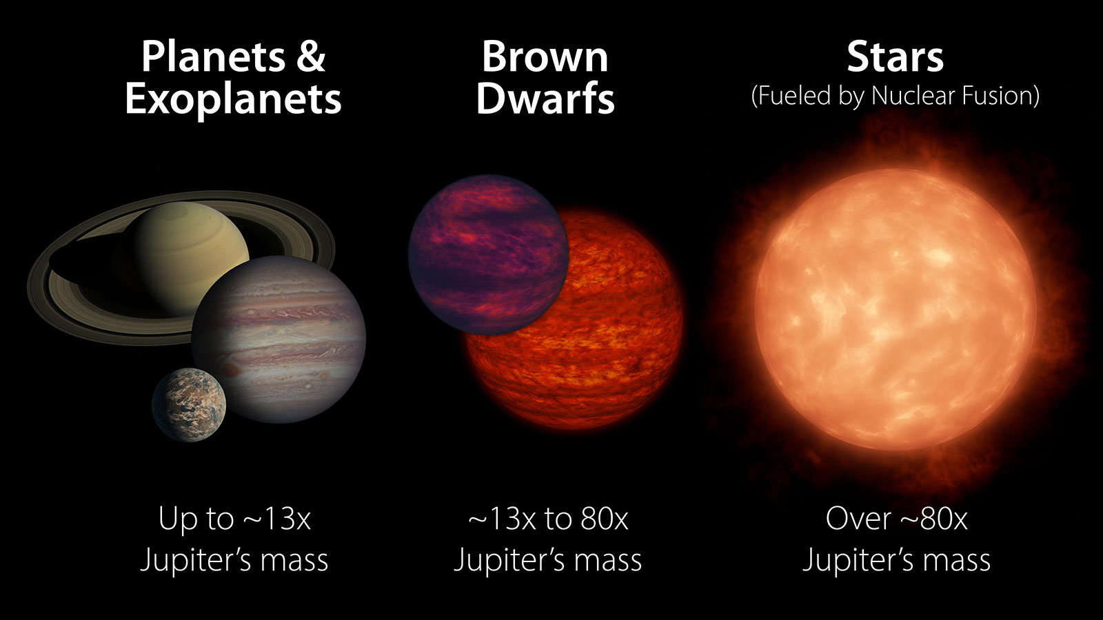
This artist’s concept shows a brown dwarf — an object larger than a planet but not massive enough to kickstart fusion in its core like a star. Brown dwarfs are hot when they form and may glow like this one, but over time they get closer in temperature to gas giant planets like Jupiter.
NOIRLab/NSF/AURA/R. Proctor
An unusual cosmic object is helping scientists better understand the chemistry hidden deep in Jupiter and Saturn’s atmospheres — and potentially those of exoplanets.
Why has silicon, one of the most common elements in the universe, gone largely undetected in the atmospheres of Jupiter, Saturn, and gas planets like them orbiting other stars? A new study using observations from NASA’s James Webb Space Telescope sheds light on this question by focusing on a peculiar object that astronomers discovered by chance in 2020 and called “The Accident.”
The results were published on Sept. 4 in the journal Nature.
As shown in this graphic, brown dwarfs can be far more massive than even large gas planets like Jupiter and Saturn. However, they tend to lack the mass that kickstarts nuclear fusion in the cores of stars, causing them to shine.
NASA/JPL-Caltech
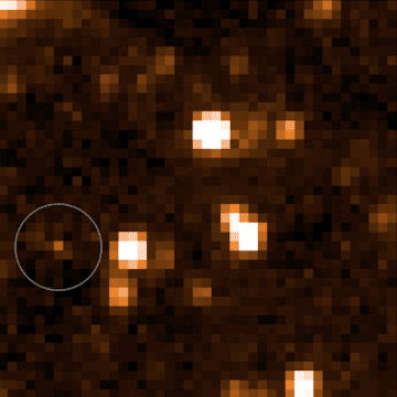
The Accident is a brown dwarf, a ball of gas that’s not quite a planet and not quite a star. Even among its already hard-to-classify peers, The Accident has a perplexing mix of physical features, some of which have been previously seen in only young brown dwarfs and others seen only in ancient ones. Because of those features, it slipped past typical detection methods before being discovered five years ago by a citizen scientist participating in Backyard Worlds: Planet 9. The program lets people around the globe look for new discoveries in data from NASA’s now-retired NEOWISE (Near-Earth Object Wide-field Infrared Survey Explorer), which was managed by NASA’s Jet Propulsion Laboratory in Southern California.
The brown dwarf nicknamed “The Accident” can be seen moving in the bottom left corner of this video, which shows data from NASA’s now-retired NEOWISE (Near-Earth Object Wide-Field Infrared Survey Explorer), launched in 2009 with the moniker WISE.
NASA/JPL-Caltech/Dan Caselden
The Accident is so faint and odd that researchers needed NASA’s most powerful space observatory, Webb, to study its atmosphere. Among several surprises, they found evidence of a molecule they couldn’t initially identify. It turned out to be a simple silicon molecule called silane (SiH4). Researchers have long expected — but been unable — to find silane not only in our solar system’s gas giants, but also in the thousands of atmospheres belonging to brown dwarfs and to the gas giants orbiting other stars. The Accident is the first such object where this molecule has been identified.
Scientists are fairly confident that silicon exists in Jupiter and Saturn’s atmospheres but that it is hidden. Bound to oxygen, silicon forms oxides such as quartz that can seed clouds on hot gas giants, bearing a resemblance to dust storms on Earth. On cooler gas giants like Jupiter and Saturn, these types of clouds would sink far beneath lighter layers of water vapor and ammonia clouds, until any silicon-containing molecules are deep in the atmosphere, invisible even to the spacecraft that have studied those two planets up close.
Some researchers have also posited that lighter molecules of silicon, like silane, should be found higher up in these atmospheric layers, left behind like traces of flour on a baker’s table. That such molecules haven’t appeared anywhere except in a single, peculiar brown dwarf suggests something about the chemistry occurring in these environments.
“Sometimes it’s the extreme objects that help us understand what’s happening in the average ones,” said Faherty, a researcher at the American Museum of Natural History in New York City, and lead author on the new study.
Happy accident
Located about 50 light-years from Earth, The Accident likely formed 10 billion to 12 billion years ago, making it one of the oldest brown dwarfs ever discovered. The universe is about 14 billion years old, and at the time that The Accident developed, the cosmos contained mostly hydrogen and helium, with trace amounts of other elements, including silicon. Over eons, elements like carbon, nitrogen, and oxygen forged in the cores of stars, so planets and stars that formed more recently possess more of those elements.
Webb’s observations of The Accident confirm that silane can form in brown dwarf and planetary atmospheres. The fact that silane seems to be missing in other brown dwarfs and gas giant planets suggests that when oxygen is available, it bonds with silicon at such a high rate and so easily, virtually no silicon is left over to bond with hydrogen and form silane.
So why is silane in The Accident? The study authors surmise it is because far less oxygen was present in the universe when the ancient brown dwarf formed, resulting in less oxygen in its atmosphere to gobble up all the silicon. The available silicon would have bonded with hydrogen instead, resulting in silane.
“We weren’t looking to solve a mystery about Jupiter and Saturn with these observations,” said JPL’s Peter Eisenhardt, project scientist for the WISE (Wide-field Infrared Survey Explorer) mission, which was later repurposed as NEOWISE. “A brown dwarf is a ball of gas like a star, but without an internal fusion reactor, it gets cooler and cooler, with an atmosphere like that of gas giant planets. We wanted to see why this brown dwarf is so odd, but we weren’t expecting silane. The universe continues to surprise us.”
Brown dwarfs are often easier to study than gas giant exoplanets because the light from a faraway planet is typically drowned out by the star it orbits, while brown dwarfs generally fly solo. And the lessons learned from these objects extend to all kinds of planets, including ones outside our solar system that might feature potential signs of habitability.
“To be clear, we’re not finding life on brown dwarfs,” said Faherty. “But at a high level, by studying all of this variety and complexity in planetary atmospheres, we’re setting up the scientists who are one day going to have to do this kind of chemical analysis for rocky, potentially Earth-like planets. It might not specifically involve silicon, but they’re going to get data that is complicated and confusing and doesn’t fit their models, just like we are. They’ll have to parse all those complexities if they want to answer those big questions.”
More about WISE, Webb
A division of Caltech, JPL managed and operated WISE for NASA’s Science Mission Directorate. The mission was selected competitively under NASA’s Explorers Program managed by the agency’s Goddard Space Flight Center in Greenbelt, Maryland. The NEOWISE mission was a project of JPL and the University of Arizona in Tucson, supported by NASA’s Planetary Defense Coordination Office.
The James Webb Space Telescope is the world’s premier space science observatory, and an international program led by NASA with its partners, ESA (European Space Agency) and CSA (Canadian Space Agency).
NASA’s Stennis Space Center is widely known for rocket propulsion testing, especially to support the NASA Artemis program to send astronauts to the Moon to prepare for future human exploration of Mars.
What may not be so widely known is that the site also is a unique federal city, home to more than 50 federal, state, academic, and commercial tenants and serving as both a model of government efficiency and a powerful economic engine for its region.
“NASA Stennis is a remarkable story of vision and innovation,” Center Director John Bailey said. “That was the case 55 years ago when the NASA Stennis federal city was born, and it remains the case today as we collaborate and grow to meet the needs of a changing aerospace world.”
Apollo Years
Nearly four years after its first Saturn V stage test, NASA’s Stennis Space Center faced a crossroads to the future. Indeed, despite its frontline role in supporting NASA’s Apollo lunar effort, it was not at all certain a viable future awaited the young rocket propulsion test site.
In 1961, NASA announced plans to build a sprawling propulsion test site in south Mississippi to support Apollo missions to the Moon. The news was a significant development for the sparsely populated Gulf Coast area.
The new site, located near Bay St. Louis, Mississippi, conducted its first hot fire of a Saturn V rocket stage in April 1966. Saturn V testing progressed steadily during the next years. In fall 1969, however, NASA announced an end to Apollo-related testing, leading to an existential crisis for the young test site.
What was to become of NASA Stennis?
An Expanded Vision
Some observers speculated the location would close or be reduced to caretaker status, with minimal staffing. Either scenario would deliver a serious blow to the families who had re-located to make way for the site and the local communities who had heavily invested in municipal projects to support the influx of workforce personnel.
Such outcomes also would run counter to assurances provided by leaders that the new test site would benefit its surrounding region and involve area residents in “something great.”
For NASA Stennis manager Jackson Balch and others, such a result was unacceptable. Anticipating the crisis, Balch had been working behind the scenes to communicate – and realize – the vision of a multiagency site supporting a range of scientific and technological tenants and missions.
A Pivotal Year
The months following the Saturn V testing announcement were filled with discussions and planning to ensure the future of NASA Stennis. The efforts began to come to fruition in 1970 with key developments:
In early 1970, NASA Administrator Thomas Paine proposed locating a regional environmental center at NASA Stennis. U.S. Sen. John C. Stennis (Mississippi) responded with a message of the president, “urgently requesting” that a National Earth Resources and Environmental Data Program be established at the site.
In May 1970, President Richard Nixon offered assurances that an Earth Resources Laboratory would be established at NASA Stennis and that at least two agencies are preparing to locate operations at the site.
U.S. congressional leaders earmarked $10 million to enable the location of an Earth Resources Laboratory at NASA Stennis.
On July 9, 1970, the U.S. Coast Guard’s National Data Buoy Project (now the National Data Buoy Center) announced it was relocating to NASA Stennis, making it the first federal city tenant. The project arrived onsite two months later on September 9.
On Sept. 9, 1970, NASA officially announced establishment of an Earth Resources Laboratory at NASA Stennis.
Time to Grow
By the end of 1970, Balch’s vision was taking shape, but it needed time to grow. The final Saturn V test had been conducted in October – with no new campaign scheduled.
A possibility was on the horizon, however. NASA was building a reusable space shuttle vehicle. It would be powered by the most sophisticated rocket engine ever designed – and the agency needed a place to conduct developmental and flight testing expected to last for decades.
Three sites vied for the assignment. Following presentations and evaluations, NASA announced its selection on March 1, 1971. Space shuttle engine testing would be conducted at NASA Stennis, providing time for the location to grow.
A Collaborative Model
By the spring of 1973, preparations for the space shuttle test campaign were progressing and NASA Stennis was on its way to realizing the federal city vision. Sixteen agencies and universities were now located at NASA Stennis.
The resident tenants followed a shared model in which they shared in the cost of basic site services, such as medical, security, and fire protection. The shared model freed up more funding for the tenants to apply towards innovation and assigned mission work. It was a model of government collaboration and efficiency.
As the site grew, leaders then began to call for it to be granted independent status within NASA, a development not long in coming. On June 14, 1974, just more than a decade after site construction began, NASA Administrator James Fletcher announced the south Mississippi location would be renamed National Space Technology Laboratories and would enjoy equal, independent status alongside other NASA centers.
“Something Great”
For NASA Stennis leaders and supporters, independent status represented a milestone moment in their effort to ensure NASA Stennis delivered on its promise of greatness.
There still were many developments to come, including the first space shuttle main engine test and the subsequent 34-year test campaign, the arrival and growth of the U.S. Navy into the predominant resident presence onsite, the renaming of the center to NASA Stennis, and the continued growth of the federal city.
No one could have imagined it all at the time. However, even in this period of early development, one thing was clear – the future lay ahead, and NASA Stennis was on its way.
NASA astronaut and Expedition 68 Flight Engineer Frank Rubio is pictured inside the cupola, the International Space Station’s “window to the world,” as the orbiting lab flew 263 miles above southeastern England on Oct. 1, 2022.
NASA/Frank Rubio
NASA astronaut Frank Rubio poses for a picture in the International Space Station’s cupola on Oct. 1, 2022.
Rubio was selected as a NASA astronaut in 2017. He trained as a flight engineer and member of the Expedition 68 crew. Rubio, along with cosmonauts Sergey Prokopyev and Dmitry Petelin of Roscosmos, launched Sept. 21, 2022, on the Soyuz MS-22 spacecraft from the Baikonur Cosmodrome in Kazakhstan to the space station.
While aboard the orbital laboratory, Rubio and his fellow crew members conducted dozens of scientific investigations and technology demonstrations, including growing tomato plants to study hydroponic and aeroponic techniques, participating in crew health experiments, and studying how materials react in microgravity. Research like this and other activity on the orbital outpost will inform long-duration missions like Artemis and future human expeditions to Mars.
Rubio spent 371 days in space, surpassing NASA’s single spaceflight record for continuous days in space made by astronaut Mark Vande Hei. Rubio and his crewmates landed in Kazakhstan on Sept. 27, 2023. Rubio’s mission is the longest single spaceflight by a U.S. astronaut in history.
NASA Webb Looks at Earth-Sized, Habitable-Zone Exoplanet TRAPPIST-1 e
This artist’s concept shows the volatile red dwarf star TRAPPIST-1 and its four most closely orbiting planets. Full image and caption shown below.
Credits: Artwork: NASA, ESA, CSA, STScI, Joseph Olmsted (STScI)
Scientists are in the midst of observing the exoplanet TRAPPIST-1 e with NASA’s James Webb Space Telescope. Careful analysis of the results so far presents several potential scenarios for what the planet’s atmosphere and surface may be like, as NASA science missions lay key groundwork to answer the question, “are we alone in the universe?”
“Webb’s infrared instruments are giving us more detail than we’ve ever had access to before, and the initial four observations we’ve been able to make of planet e are showing us what we will have to work with when the rest of the information comes in,” said Néstor Espinoza of the Space Telescope Science Institute in Baltimore, Maryland, a principal investigator on the research team. Two scientificpapers detailing the team’s initial results are published in the Astrophysical Journal Letters.
Image A: Trappist-1 e (Artist’s Concept)
This artist’s concept shows the volatile red dwarf star TRAPPIST-1 and its four most closely orbiting planets, all of which have been observed by NASA’s James Webb Space Telescope. Webb has found no definitive signs of an atmosphere around any of these worlds yet.
Artwork: NASA, ESA, CSA, STScI, Joseph Olmsted (STScI)
Of the seven Earth-sized worlds orbiting the red dwarf star TRAPPIST-1, planet e is of particular interest because it orbits the star at a distance where water on the surface is theoretically possible — not too hot, not too cold — but only if the planet has an atmosphere. That’s where Webb comes in. Researchers aimed the telescope’s powerful NIRSpec (Near-Infrared Spectrograph) instrument at the system as planet e transited, or passed in front of, its star. Starlight passing through the planet’s atmosphere, if there is one, will be partially absorbed, and the corresponding dips in the light spectrum that reaches Webb will tell astronomers what chemicals are found there. With each additional transit, the atmospheric contents become clearer as more data is collected.
Primary atmosphere unlikely
Though multiple possibilities remain open for planet e because only four transits have been analyzed so far, the researchers feel confident that the planet does not still have its primary, or original, atmosphere. TRAPPIST-1 is a very active star, with frequent flares, so it is not surprising to researchers that any hydrogen-helium atmosphere with which the planet may have formed would have been stripped off by stellar radiation. However many planets, including Earth, build up a heavier secondary atmosphere after losing their primary atmosphere. It is possible that planet e was never able to do this and does not have a secondary atmosphere. Yet researchers say there is an equal chance there is an atmosphere, and the team developed novel approaches to working with Webb’s data to determine planet e’s potential atmospheres and surface environments.
World of (fewer) possibilities
The researchers say it is unlikely that the atmosphere of TRAPPIST-1 e is dominated by carbon dioxide, analogous to the thick atmosphere of Venus and the thin atmosphere of Mars. However, the researchers also are careful to note that there are no direct parallels with our solar system.
“TRAPPIST-1 is a very different star from our Sun, and so the planetary system around it is also very different, which challenges both our observational and theoretical assumptions,” said team member Nikole Lewis, an associate professor of astronomy at Cornell University.
If there is liquid water on TRAPPIST-1 e, the researchers say it would be accompanied by a greenhouse effect, in which various gases, particularly carbon dioxide, keep the atmosphere stable and the planet warm.
“A little greenhouse effect goes a long way,” said Lewis, and the measurements do not rule out adequate carbon dioxide to sustain some water on the surface. According to the team’s analysis, the water could take the form of a global ocean, or cover a smaller area of the planet where the star is at perpetual noon, surrounded by ice. This would be possible because, due to the TRAPPIST-1 planets’ sizes and close orbits to their star, it is thought that they all are tidally locked, with one side always facing the star and one side always in darkness.
Image B: TRAPPIST-1 e Transmission Spectrum (NIRSpec)
This graphic compares data collected by Webb’s NIRSpec (Near-Infrared Spectrograph) with computer models of exoplanet TRAPPIST-1 e with (blue) and without (orange) an atmosphere. Narrow colored bands show the most likely locations of data points for each model.
Illustration: NASA, ESA, CSA, STScI, Joseph Olmsted (STScI)
Innovative new method
Espinoza and co-principal investigator Natalie Allen of Johns Hopkins University are leading a team that is currently making 15 additional observations of planet e, with an innovative twist. The scientists are timing the observations so that Webb catches both planets b and e transiting the star one right after the other. After previous Webb observations of planet b, the planet orbiting closest to TRAPPIST-1, scientists are fairly confident it is a bare rock without an atmosphere. This means that signals detected during planet b’s transit can be attributed to the star only, and because planet e transits at nearly the same time, there will be less complication from the star’s variability. Scientists plan to compare the data from both planets, and any indications of chemicals that show up only in planet e’s spectrum can be attributed to its atmosphere.
“We are really still in the early stages of learning what kind of amazing science we can do with Webb. It’s incredible to measure the details of starlight around Earth-sized planets 40 light-years away and learn what it might be like there, if life could be possible there,” said Ana Glidden, a post-doctoral researcher at Massachusetts Institute of Technology’s Kavli Institute for Astrophysics and Space Research, who led the research on possible atmospheres for planet e. “We’re in a new age of exploration that’s very exciting to be a part of,” she said.
The four transits of TRAPPIST-1 e analyzed in the new papers published today were collected by the JWST Telescope Scientist Team’s DREAMS (Deep Reconnaissance of Exoplanet Atmospheres using Multi-instrument Spectroscopy) collaboration.
The James Webb Space Telescope is the world’s premier space science observatory. Webb is solving mysteries in our solar system, looking beyond to distant worlds around other stars, and probing the mysterious structures and origins of our universe and our place in it. Webb is an international program led by NASA with its partners, ESA (European Space Agency) and CSA (Canadian Space Agency).
This artist’s concept shows the volatile red dwarf star TRAPPIST-1 and its four most closely orbiting planets, all of which have been observed by NASA’s James Webb Space Telescope. Webb has found no definitive signs of an atmosphere around any of these worlds yet.
TRAPPIST-1 e Transmission Spectrum (NIRSpec)
This graphic compares data collected by Webb’s NIRSpec (Near-Infrared Spectrograph) with computer models of exoplanet TRAPPIST-1 e with (blue) and without (orange) an atmosphere. Narrow colored bands show the most likely locations of data points for each model.
Students prepare their robots to enter Artemis Arena during NASA’s Lunabotics competition on May 20, 2025, at the Center for Space Education near the Kennedy Space Center Visitor Complex in Florida.
NASA/Isaac Watson
As college students across the country embark upon the academic year, NASA is giving them something else to look forward to – the agency’s 2026 Lunabotics Challenge. Teams interested in participating can submit their applications and supporting materials through NASA’s Stem Gateway portal beginning Monday, Sept. 8.
Key dates and challenge details are available in the 2026 Lunabotics Challenge Guidebook. Once all applications and supporting materials are received and evaluated, NASA will notify the selected teams to begin the challenge.
Student teams participating in this year’s challenge will create robots capable of building berms out of lunar regolith – the loose, fragmental material on the Moon’s surface. Structures like these will be important during lunar missions as blast protection during lunar landings and launches, shading for cryogenic propellant tank farms, radiation shielding around nuclear power plants, and other uses critical to future Moon missions.
“We are excited to continue the Lunabotics competition for universities as NASA develops new Moon to Mars technologies for the Artemis program,” said Robert Mueller, senior technologist at NASA, as well as co-founder and chief judge of the Lunabotics competition. “Excavating and moving regolith is a fundamental need to build infrastructure on the Moon and Mars and this competition creates 21st century skills in the future workforce.”
An in-person qualifying event will be held May 12-17, 2026, at the University of Central Florida’s Space Institute’s Exolith Lab in Orlando. From this round, the top 10 teams will be invited to bring their robots to the final competition on May 19-21, at the Kennedy Space Center Visitor Complex’s Artemis Arena in Florida, which has an area filled with a lunar regolith simulant. The team scoring the most points will receive the Lunabotics Grand Prize and participate in an exhibition-style event at NASA Kennedy.
By encouraging innovative construction techniques and assessing student designs and data the same way it does its own prototypes, NASA casts a wider net to find innovative solutions to challenges inherent in future Artemis missions, like developing future lunar excavators, in-situ resource utilization capabilities, and living on the Moon or Mars. With its multidisciplinary approach, Lunabotics also serves as a workforce pipeline, with teams gaining valuable hands-on experience in computer coding, engineering, manufacturing, fabricating, and other crucial skills, while also receiving technical expertise in space technology development.
NASA’s Lunabotics Challenge, held annually since 2010, is one of several Artemis Student Challenges. The two-semester competition provides U.S. college and technical school teams an opportunity to design, build, and operate a prototype lunar robot using NASA systems engineering processes. Competitions help NASA get innovative design and operational data, reduce risks, and cultivate new ideas needed to return to the Moon under the Artemis campaign to prepare for human exploration of Mars.
A child of the Space Shuttle Program, Jeni Morrison grew up walking the grounds of NASA’s Johnson Space Center in Houston with her parents and listening to family stories about human spaceflight.
Now, with more than 15 years at NASA, Morrison serves as one of Johnson’s Environmental Programs managers. She ensures the center complies with laws that protect its resources by overseeing regulatory compliance for cultural and natural resources, stormwater and drinking water programs, and the National Environmental Policy Act. She also safeguards Johnson’s historic legacy as Johnson’s Cultural Resources manager.
Jeni Morrison in the mall area at NASA’s Johnson Space Center in Houston, where employees often see local wildlife, including turtles, birds, deer, and the occasional alligator.
“I make sure our actions comply with the National Historic Preservation act, since the center is considered a historic district with two National Historic Landmarks onsite,” Morrison said. “I make sure we respect and document Johnson’s heritage while paving the way for new efforts and mission objectives.”
Morrison takes pride in finding solutions that increase efficiency while protecting resources. One example was a project with Johnson’s Geographic Information System team to create an interactive material and chemical spill plan map. The new system helps responders quickly trace spill paths above and underground to deploy resources faster, reducing cleanup costs and minimizing environmental impacts.
“Every improvement we make not only saves time and resources, but strengthens our ability to support NASA’s mission,” she said.
By the very nature of our work, NASA makes history all the time. That history is important for all people, both to remember the sacrifices and accomplishments of so many, but also to ensure we don’t repeat mistakes as we strive for even bolder achievements.
Jeni Morrison
Environmental Program Manager
Jeni Morrison presents an overview of environmental compliance and center initiatives to employees at NASA’s Johnson Space Center in 2014.
NASA/Lauren Harnett
For Morrison, success often comes down to teamwork. She has learned to adapt her style to colleagues’ needs to strengthen collaboration.
“By making the effort to accommodate others’ communication styles and learn from different perspectives, we create better, more efficient work,” she said. “Thankfully, so many people here at NASA are willing to teach and to share their experiences.”
Her message to the Artemis Generation is simple: Always keep learning!
“You never know when a side conversation could give you an answer to a problem you are facing down the line,” she said. “You must be willing to ask questions and learn something new to find those connections.”
Jeni Morrison (second from right) with the Biobased Coolant Project Team at NASA’s Johnson Space Center in 2018. The team tested biobased metalworking coolants and identified a product that outperformed petroleum-based options, meeting flight hardware specifications while reducing waste disposal costs and labor hours.
Even as a young child visiting NASA Johnson, I could feel the sense of adventure, accomplishment, and the drive to reach new heights of human capability. I realize that those experiences gave me a fascination with learning and an inherent need to find ways to do things better.
jENI mORRISON
Environmental Program Manager
Her passion for learning and discovery connects to a family tradition at NASA. Her grandfather contributed to multiple Apollo missions, including helping solve the oxygen tank malfunction on Apollo 13. Her mother worked at the center transcribing astronaut recordings and writing proposals, and her father flew experiments aboard the space shuttle and International Space Station. Morrison’s sister and extended family also worked at Johnson.
Now her son is growing up on the center grounds while attending the JSC Child Care Center. “As the fourth generation to be at Johnson, he is already talking about how he loves science and can’t wait to do his own experiments,” she said.
For Morrison, carrying that family legacy forward through environmental stewardship is a privilege. “Being able to contribute to NASA’s mission through environmental compliance feels like the best of both worlds for me,” Morrison said. “It combines my love of science and NASA with my drive to find more efficient ways to operate while protecting this incredible site and everything it represents.”
This website uses cookies to improve your experience. We'll assume you're ok with this, but you can opt-out if you wish.AcceptRead More
Privacy & Cookies Policy
Privacy Overview
This website uses cookies to improve your experience while you navigate through the website. Out of these, the cookies that are categorized as necessary are stored on your browser as they are essential for the working of basic functionalities of the website. We also use third-party cookies that help us analyze and understand how you use this website. These cookies will be stored in your browser only with your consent. You also have the option to opt-out of these cookies. But opting out of some of these cookies may affect your browsing experience.
Necessary cookies are absolutely essential for the website to function properly. This category only includes cookies that ensures basic functionalities and security features of the website. These cookies do not store any personal information.
Any cookies that may not be particularly necessary for the website to function and is used specifically to collect user personal data via analytics, ads, other embedded contents are termed as non-necessary cookies. It is mandatory to procure user consent prior to running these cookies on your website.