Webb’s image of the enormous stellar jet in Sh2-284 provides evidence that protostellar jets scale with the mass of their parent stars—the more massive the stellar engine driving the plasma, the larger the resulting jet.
Tag: space
-
The journey of Juice – episode 2

Video:
00:12:24ESA’s Jupiter Icy Moons Explorer (Juice) is on an epic eight-year journey to Jupiter. It left Earth in April 2023 and is due to arrive at the gas giant in 2031.
2025 has been another big year for Juice. It made its closest approach to the Sun and flew close by Venus for a gravity boost to help it on its way. This second episode of ‘The journey of Juice’ takes us on a journey of our own, discovering what Juice – and the humans behind it – have experienced this year.
In a clean room at ESA’s technical centre, thermal engineer Romain Peyrou-Lauge shows us the technologies that protect Juice from the intense heat of the Sun during this period.
In Uppsala, Sweden, scientists get together for a ‘science working team’ meeting to discuss the scientific aspects of the mission. Juice Project Scientist Olivier Witasse talks about how important it is to continue working as a team to prepare for Juice’s precious time spent collecting data at Jupiter.
The video culminates with operations engineer Marc Costa taking us to the Cebreros station in Madrid for the Venus flyby. There we meet deputy station manager Jorge Fauste, Juice intern Charlotte Bergot and Juice Mission Manager Nicolas Altobelli.
This series follows on from ‘The making of Juice’ series, which covered the planning, testing and launch of this once-in-a-generation mission.
-
Swarm detects rare proton spike during solar storm

The European Space Agency’s Swarm mission detected a large but temporary spike of high-energy protons at Earth’s poles during a geomagnetic storm in November. It did this not with the scientific instruments for measuring Earth’s magnetic field, but with its ‘star tracker’ positioning instruments – a first for the Swarm mission.
-
Space-enabled air traffic control takes flight globally

Air travellers will shrink their carbon footprint while reducing flight delays worldwide, thanks to a collaboration between the European Space Agency (ESA), satellite operator Viasat and aerospace company Boeing. Flights to test the space-based technology with new aviation standards from and to the USA and Europe took place in late October and early November.
-
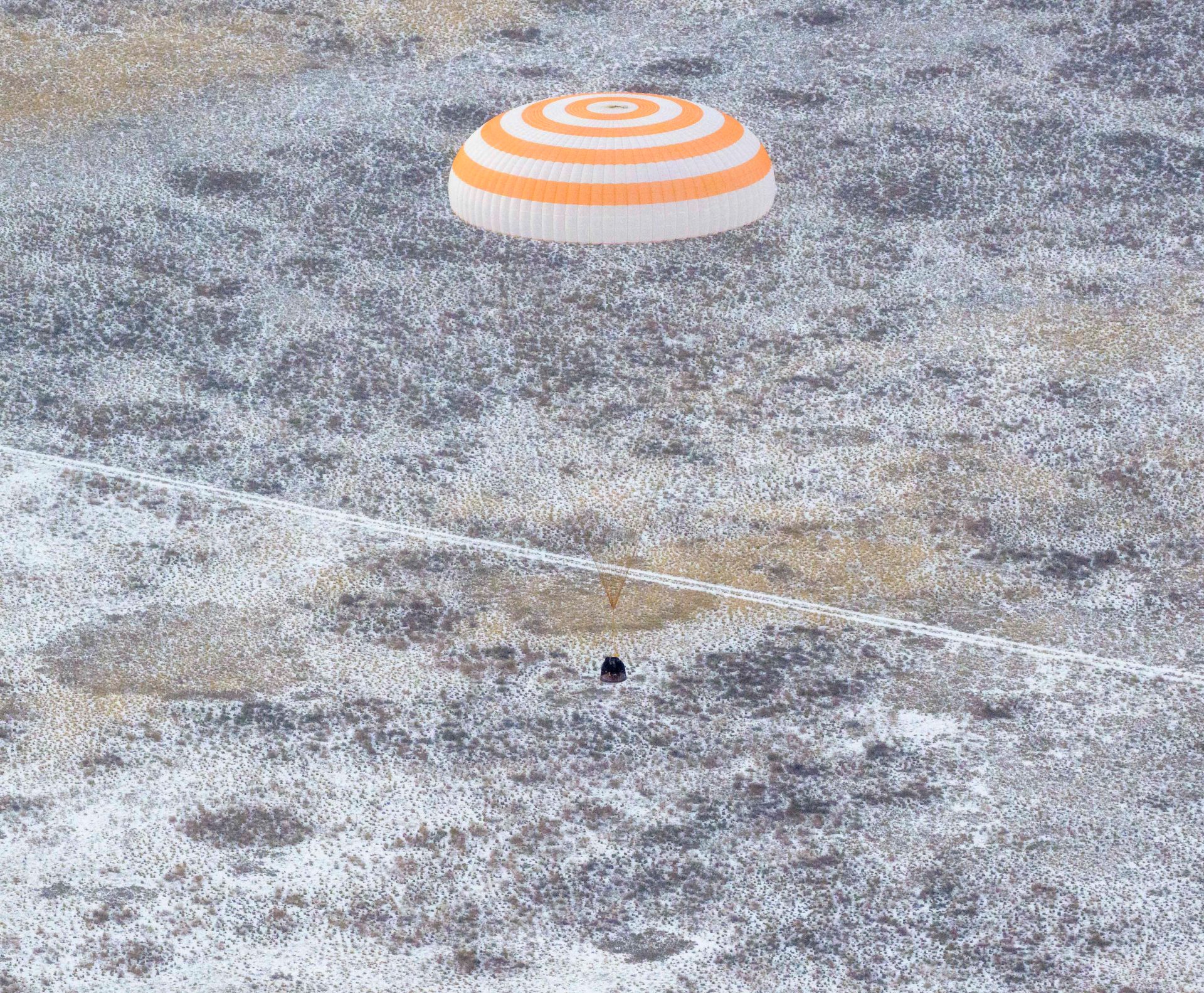
NASA Astronaut Jonny Kim Returns to Earth
The Soyuz MS-27 spacecraft is seen as it lands in a remote area near the town of Zhezkazgan, Kazakhstan with Expedition 73 NASA astronaut Jonny Kim, and Roscosmos cosmonauts Sergey Ryzhikov and Alexey Zubritsky aboard, Tuesday, Dec. 9, 2025.
-
Funding boost unlocks future space science programme

In its 50th anniversary year, European Space Agency (ESA) Member States have recommitted to space science. A historic budget increase for the Science Programme of 3.5% per year through to 2028, in addition to inflation, will enable some of the most ambitious missions ever, and bolster European leadership in space science.
-
NASA Demonstrates Safer Skies for Future Urban Air Travel
2 min read
Preparations for Next Moonwalk Simulations Underway (and Underwater)
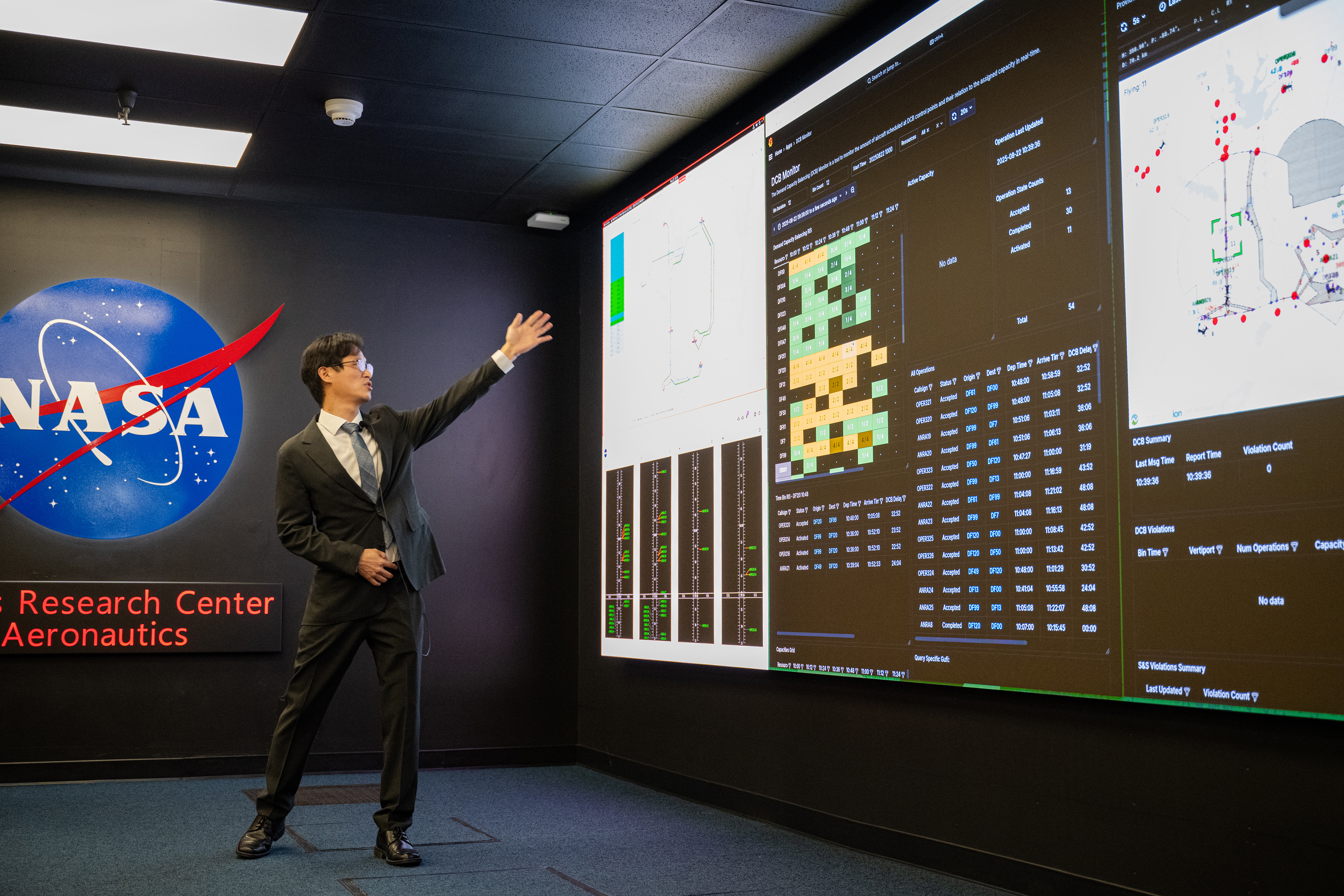
 NASA engineer Hanbong Lee demonstrates capabilities to manage busy urban airspace traffic during a recent simulation at NASA’s Ames Research Center in California’s Silicon Valley.NASA/Brandon Torres-Navarrete
NASA is helping shape the future of urban air travel with a new simulation that will manage how electric air taxis and drones can successfully operate within busy areas.
The demonstration, held at NASA’s Ames Research Center in California’s Silicon Valley earlier this year, focused on a system called the Strategic Deconfliction Simulation, which helps coordinate flight plans before takeoff, reducing the risk of conflicts in busy urban environments
At the event, researchers demonstrated NASA’s Situational Viewer and Demand-Capacity Balancing Monitor, which visualizes air traffic and adjusts flight plans in real time. The simulation demonstrated traffic scenarios involving drone operations throughout the Dallas-Fort Worth area, testing how preplanned flights could improve congestion and manage the demand and capacity of the airspace – ensuring that all aircraft can operate smoothly even in crowded conditions.
Working with industry partners is critical to NASA’s efforts to develop and refine technologies needed for future air mobility. During the simulation, the company, ANRA Technologies, demonstrated its fleet and vertiport management systems, which are designed to support the coordination of multiple aircraft and ground operations.
“Simulating these complex environments supports broader efforts to ensure safe integration of drones and other advanced vehicles into the US airspace,” said Hanbong Lee, engineer at NASA Ames. “By showcasing these capabilities, we’re delivering critical data and lessons learned to support efforts at NASA and industry.”
This demonstration is another step toward the NASA team’s plan to hold a technical capability level simulation in 2026. This upcoming simulation would help shape the development of services aimed at managing aircraft flying in urban areas.
The simulation was created through a NASA team from its Air Mobility Pathfinders project, part of the agency’s continuing work to find solutions for safely integrating innovative new aircraft such as air taxis into U.S. cities and the national airspace. By developing advanced evaluations and simulations, the project supports safe, scalable, and publicly trusted air travel in urban areas, paving the way for a future where air taxis and drones are a safe and reliable part of everyday life.
The project falls under NASA’s Airspace Operations and Safety Program, which works to enable safe and efficient aviation transportation.
Share
Details
Last UpdatedDec 09, 2025Related Terms
Explore More
-
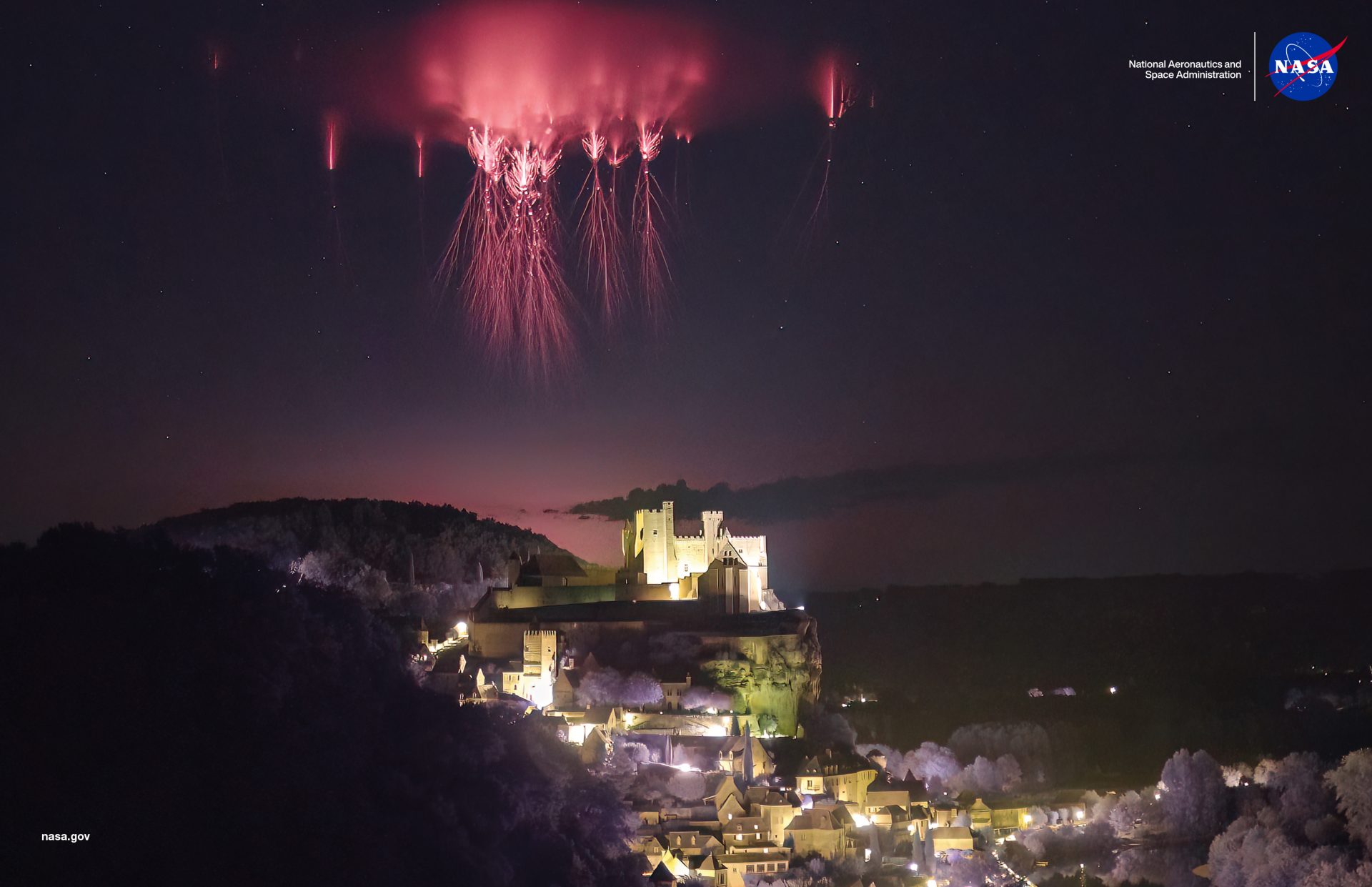
Sprites Over Château de Beynac
A flash of lightning, and then—something else. High above a storm, a crimson figure blinks in and out of existence. If you see it, you are a lucky witness of a sprite, one of the least-understood electrical phenomena in Earth’s upper atmosphere.
-
New NASA Sensor Goes Hunting for Critical Minerals
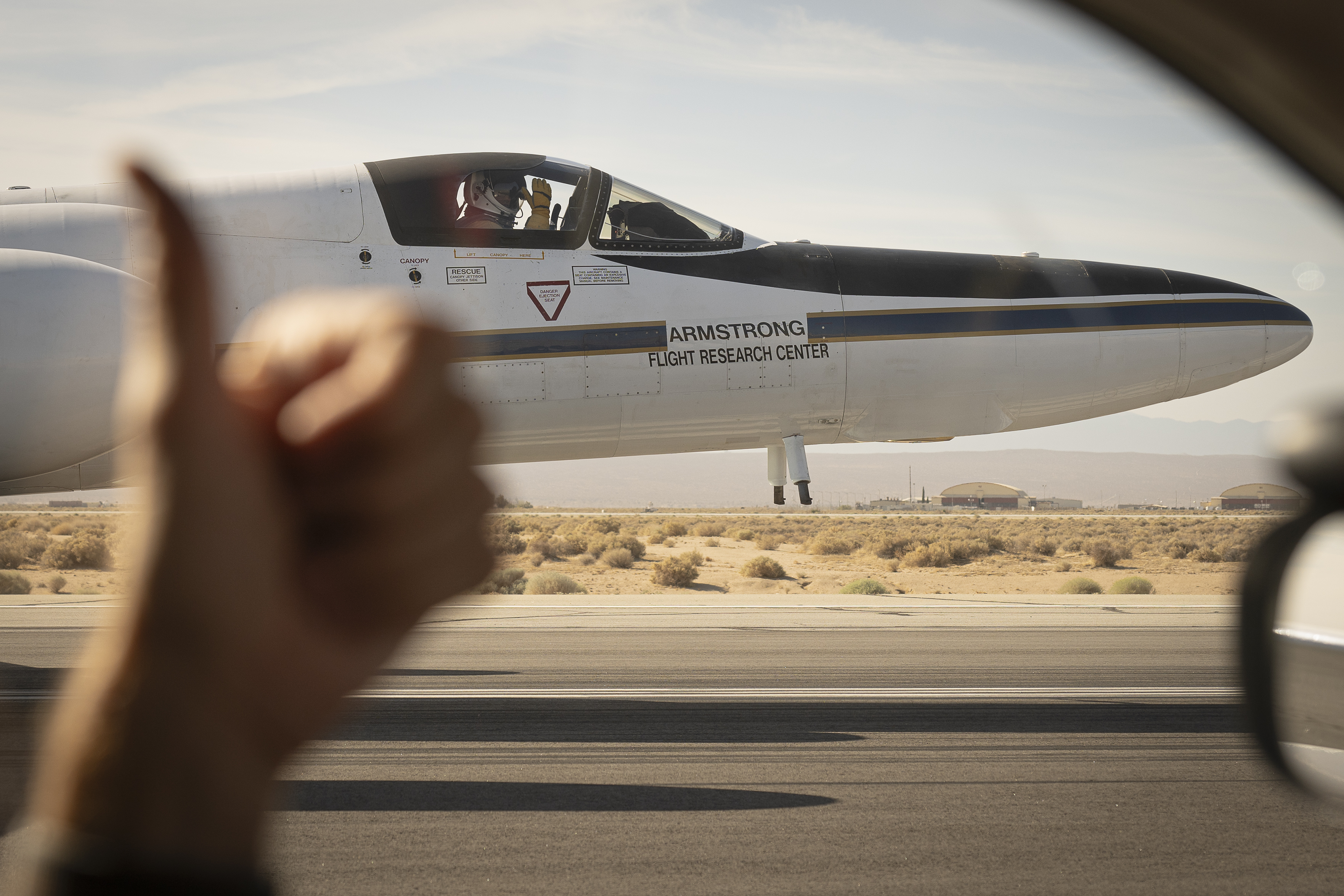
 A pilot signals to a crew member before takeoff from NASA’s Armstrong Flight Research Center in Edwards, California, on Aug. 21, 2025. Accompanying him in the high-flying ER-2 aircraft is one of the most advanced imaging spectrometers in the solar system.NASA/Christopher LC Clark
Called AVIRIS-5, it’s the latest in a long line of sensors pioneered by NASA JPL to survey Earth, the Moon, and other worlds.
Cradled in the nose of a high-altitude research airplane, a new NASA sensor has taken to the skies to help geoscientists map rocks hosting lithium and other critical minerals on Earth’s surface some 60,000 feet below. In collaboration with the U.S. Geological Survey (USGS), the flights are part of the largest airborne campaign of its kind in the country’s history.
But that’s just one of many tasks that are on the horizon for AVIRIS-5, short for Airborne Visible/Infrared Imaging Spectrometer-5, which has a lot in common with sensors used to explore other planets.
NASA’s AVIRIS flies aboard a research plane in this animation, detecting minerals on the ground such as hectorite — a lithium-bearing clay — by the unique patterns of light that they reflect. The different wavelengths, measured in nanometers, look like colorful squiggles in the box on the right. Credit: NASA’s Conceptual Image Lab About the size of a microwave oven, AVIRIS-5 detects the spectral “fingerprints” of minerals and other compounds in reflected sunlight. Like its cousins flying in space, the sensor takes advantage of the fact that all kinds of molecules, from rare earth elements to flower pigments, have unique chemical structures that absorb and reflect different wavelengths of light.
The technology was pioneered at NASA’s Jet Propulsion Laboratory in Southern California in the late 1970s. Over the decades, imaging spectrometers have visited every major rocky body in the solar system from Mercury to Pluto. They’ve traced Martian crust in full spectral detail, revealed lakes on Titan, and tracked mineral-rich dust across the Sahara and other deserts. One is en route to Europa, an ocean moon of Jupiter, to search for the chemical ingredients needed to support life.
 Image cubes illustrate the volume of data returned by JPL imaging spectrometers. The front panel shows roads and fields around Tulare, California, as seen by AVIRIS-5 during a checkout flight earlier this year. The side panels depict the spectral fingerprint captured for every point in the image.NASA/JPL-Caltech
Another imaging spectrometer, NASA’s Moon Mineralogy Mapper, was the first to discover water on the lunar surface in 2009. “That dataset continues to drive our investigations as we look for in situ resources on the Moon” as part of NASA’s Artemis campaign, said Robert Green, a senior research scientist at NASA JPL who’s contributed to multiple spectroscopy missions across the solar system.
Prisms, black silicon
While imaging spectrometers vary depending on their mission, they have certain hardware in common — including mirrors, detector arrays, and electron-beam gratings — designed to capture light shimmering off a surface and then separate it into its constituent colors, like a prism.
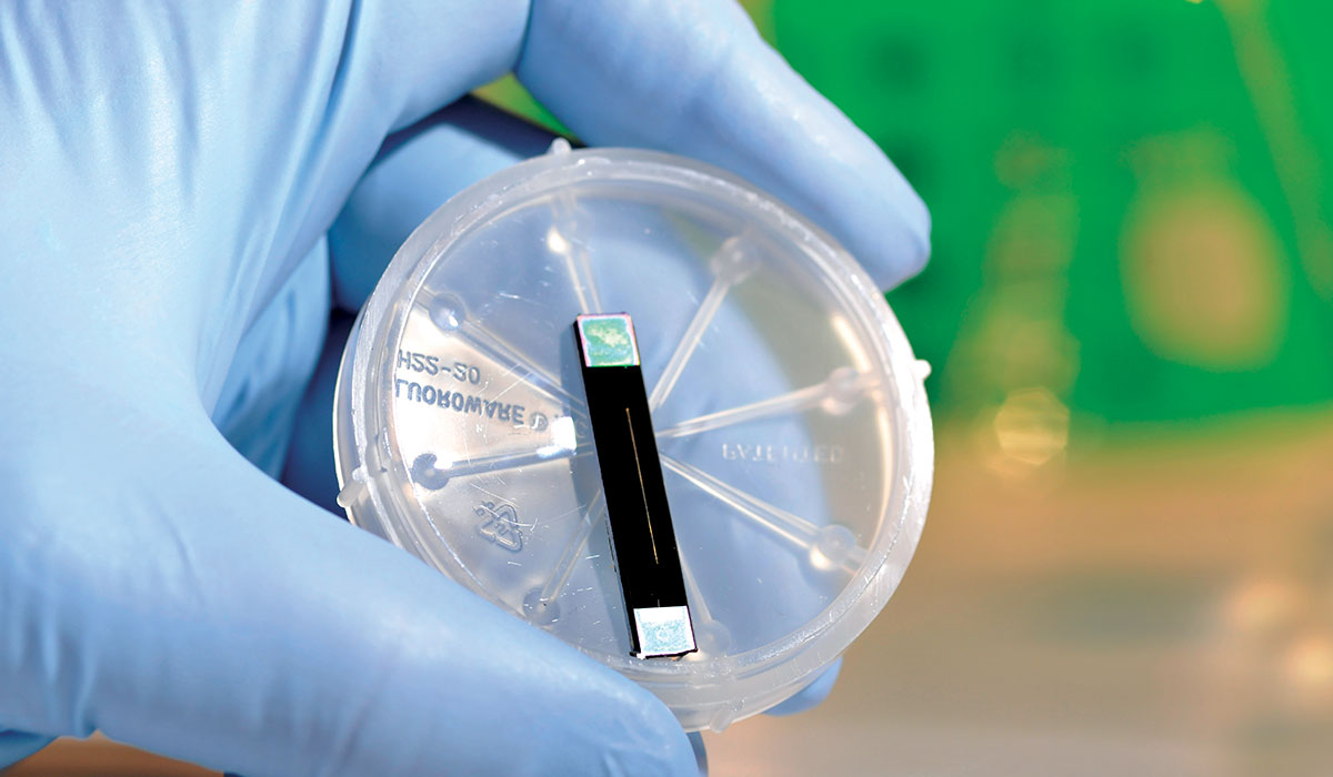
 Light-trapping black silicon is one of the darkest materials ever fabricated. The technology is standard for JPL’s ultraprecise imaging spectrometers.NASA/JPL-Caltech
Many of the best-in-class imaging spectrometers flying today were made possible by components invented at NASA JPL’s Microdevices Laboratory. Instrument-makers there combine breakthroughs in physics, chemistry, and material science with the classical properties of light discovered by physicist Isaac Newton in the 17th century. Newton’s prism experiments revealed that visible light is composed of a rainbow of colors.
Today, NASA JPL engineers work with advanced materials such as black silicon — one of the darkest substances ever manufactured — to push performance. Under a powerful microscope, black silicon looks like a forest of spiky needles. Etched by lasers or chemicals, the nanoscale structures prevent stray light from interfering with the sample by trapping it in their spikes.
Treasure hunting
The optical techniques used at the Microdevices Laboratory have advanced continuously since the first AVIRIS instrument took flight in 1986. Four generations of these sensors have now hit the skies, analyzing erupting volcanoes, diseased crops, ground zero debris in New York City, and wildfires in Alabama, among many other deployments. The latest model, AVIRIS-5, features spatial resolution that’s twice as fine as that of its predecessor and can resolve areas ranging from less than a foot (30 centimeters) to about 30 feet (10 meters).
So far this year, it has logged more than 200 hours of high-altitude flights over Nevada, California, and other Western states as part of a project called GEMx (Geological Earth Mapping Experiment). The flights are conducted using NASA’s ER-2 aircraft, operated out of the agency’s Armstrong Flight Research Center in Edwards, California. The effort is the airborne component of a larger USGS initiative, called Earth Mapping Resources Initiative (Earth MRI), to modernize mapping of the nation’s surface and subsurface.
The NASA and USGS team has, since 2023, gathered data over more than 366,000 square miles (950,000 square kilometers) of the American West, where dry, treeless expanses are well suited to mineral spectroscopy.
An exciting early finding is a lithium-bearing clay called hectorite, identified in the tailings of an abandoned mine in California, among other locations. Lithium is one of about 50 minerals at risk of supply chain disruption that USGS has deemed critical to national security and the economy.
Helping communities capture new value from old and abandoned prospects is one of the long-term aspirations of GEMx, said Dana Chadwick, an Earth system scientist at NASA JPL. So is identifying sources of acid mine drainage, which can occur when waste rocks weather and leach into the environment.
“The breadth of different questions you can take on with this technology is really exciting, from land management to snowpack water resources to wildfire risk,” Chadwick said. “Critical minerals are just the beginning for AVIRIS-5.”
More about GEMx
The GEMx research project is expected to last four years and is funded by the USGS Earth MRI, through investments from the Bipartisan Infrastructure Law. The initiative will capitalize on both the technology developed by NASA for spectroscopic imaging, as well as the expertise in analyzing the datasets and extracting critical mineral information from them.
To learn more about GEMx visit:
https://science.nasa.gov/mission/gemx/
News Media Contacts
Andrew Wang / Andrew Good
Jet Propulsion Laboratory, Pasadena, Calif.
626-379-6874 / 818-393-2433
andrew.wang@jpl.nasa.gov / andrew.c.good@jpl.nasa.govWritten by Sally Younger
2025-136
Share
Details
Last UpdatedDec 09, 2025Related Terms
Explore More
-
Webb identifies earliest supernova to date

The NASA/ESA/CSA James Webb Space Telescope has confirmed the source of a super-bright flash of light known as a gamma-ray burst, generated by an exploding massive star when the Universe was only 730 million years old. For the first time for such a remote event, the telescope provided a detection of the supernova’s host galaxy. Webb’s quick-turnaround observations verified data taken by telescopes around the world that had been following the gamma-ray burst since it onset, which occurred in mid-March.
-
Galileo pre-launch media briefing

Video:
00:42:04Watch the replay of the media briefing held ahead of the 14th operational launch of the Galileo programme. The briefing covers the mission details for the launch of two Galileo satellites, which are set to lift off on 17 December aboard Ariane 6 from Europe’s Spaceport in French Guiana.
-
Flaring black hole whips up ultra-fast winds

Leading X-ray space telescopes XMM-Newton and XRISM have spotted an extraordinary blast from a supermassive black hole. In a matter of hours, the gravitational monster whipped up powerful winds, flinging material out into space at eye-watering speeds of 60 000 km per second.
-

XRISM Finds Chlorine, Potassium in Cas A
This composite image of the Cassiopeia A (or Cas A) supernova remnant, released Jan. 8, 2024, contains X-rays from Chandra (blue), infrared data from Webb (red, green, blue), and optical data from Hubble (red and white). A study by the XRISM (X-ray Imaging and Spectroscopy Mission) spacecraft has made the first-ever X-ray detections of chlorine and potassium in the wreckage.