Tag: NASA

  • NASA Tests 5G-Based Aviation Network to Boost Air Taxi Connectivity

    4 min read

    Preparations for Next Moonwalk Simulations Underway (and Underwater)

    A man in a tan flight suit with a headset and microphone is sitting in a plane holding a piece of white paper. He is looking at communication equipment in the back of the plane. The equipment is comprised of large orange metal boxes with dials connected by wires to a blue computer drive rack.
    NASA researcher Darren Nash monitors experimental communications equipment on NASA’s Pilatus PC-12 during a flight test over NASA’s Glenn Research Center in Cleveland on April 17, 2025.
    NASA/Sara Lowthian-Hanna

    NASA engineers are exploring how the technology used in existing cellphone networks could support the next generation of aviation.

    In April and May, researchers at NASA’s Glenn Research Center in Cleveland built two specialized radio systems to study how well fifth-generation cellular network technology, known as 5G, can handle the demands of air taxi communications.

    “The goal of this research is to understand how wireless cellphone networks could be leveraged by the aviation industry to enable new frontiers of aviation operations,” said Casey Bakula, lead researcher for the project, who is based at Glenn. “The findings of this work could serve as a blueprint for future aviation communication network providers, like satellite navigation providers and telecommunications companies, and help guide the Federal Aviation Administration’s plan for future advanced air mobility network requirements in cities.”

    Instead of developing entirely new standards for air taxi communications, NASA is looking to see if the aviation industry could leverage the expertise, experience, and investments made by the cellular industry towards the development of reliable, secure, and scalable aviation networks. If 5G networks could provide an “80% solution” to the challenge, researchers can focus on identifying the remaining 20% that would need to be adapted to meet the needs of the air taxi industry.

    One man in a tan flight suit is sitting at a computer control station on a plane, while another man, also in a tan flight suit looks over his shoulder at flight test data on the control station screen. The control station is enclosed in a black metal box with a keyboard underneath.
    NASA researchers Darren Nash, left, and Brian Kachmar review signal data captured from experimental communications equipment onboard NASA’s Pilatus PC-12 on April 17, 2025.
    NASA/Sara Lowthian-Hanna

    5G networks can manage a lot of data at once and have very low signal transmission delay compared to satellite systems, which could make them ideal for providing location data between aircraft in busy city skies. Ground antennas and networks in cities can help air taxis stay connected as they fly over buildings, making urban flights safer.

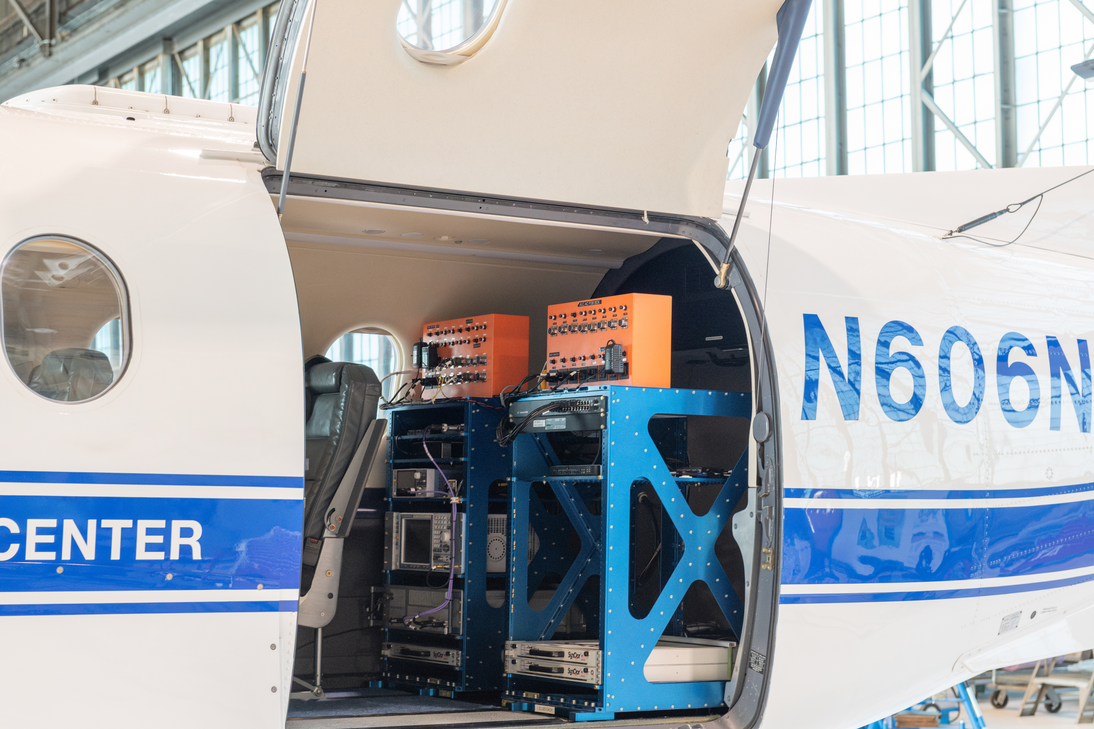
    To conduct their tests, NASA researchers set up a system that meets current 5G standards and would allow for future improvements in performance. They placed one radio in the agency’s Pilatus PC-12 aircraft and set up another radio on the roof of Glenn’s Aerospace Communications Facility building. With an experimental license from the Federal Aviation Administration (FAA) to conduct flights, the team tested signal transmissions using a radio frequency band the Federal Communications Commission dedicated for the safe testing of drones and other uncrewed aircraft systems.

    During testing, NASA’s PC-12 flew various flight patterns near Glenn. The team used some of the flight patterns to measure how the signal could weaken as the aircraft moved away from the ground station. Other patterns focused on identifying areas where nearby buildings might block signals, potentially causing interference or dead zones. The team also studied how the aircraft’s angle and position relative to the ground station affected the quality of the connection.

    These initial tests provided the NASA team an opportunity to integrate its new C-Band radio testbed onto the aircraft, verify its basic functionality, and the operation of the corresponding ground station, as well as refine the team’s test procedures. The successful completion of these activities allows the team to begin research on how 5G standards and technologies could be utilized in existing aviation bands to provide air-to-ground and aircraft-to-aircraft communications services. 

    Experimental communications equipment housed in orange metal boxes, on blue metal computers racks are in the back of a white plane with a blue stripe which is parked inside a hangar. The equipment is seen through an open cargo door.
    Experimental communications equipment is secure and ready for flight test evaluation in the back of NASA’s Pilatus PC-12 at NASA’s Glenn Research Center in Cleveland on April 17, 2025.
    NASA/Sara Lowthian-Hanna

    In addition to meeting these initial test objectives, the team also recorded and verified the presence of propeller modulation. This is a form of signal degradation caused by the propeller blades of the aircraft partially blocking radio signals as they rotate. The effect becomes more significant as aircraft fly at the lower altitudes air taxis are expected to operate. The airframe configuration and number of propellers on some of the new air taxi models may cause increased propeller modulation effects, so NASA researchers will study this further.   

    NASA research will provide baseline performance data that the agency will share with the FAA and the advanced air mobility sector of the aviation industry, which explores new air transportation options. Future research looking into cellular network usage will focus on issues such as maximum data speeds, signal-to-noise ratios, and synchronization between aircraft and ground systems. Researchers will be able to use NASA’s baseline data to measure the potential of new changes or features to communications systems.

    Future aircraft will need to carry essential communications systems for command and control, passenger safety, and coordination with other aircraft to avoid collisions. Reliable wireless networks offer the possibility for safe operations of air taxis, particular in cities and other crowded areas.

    This work is led by NASAs Air Mobility Pathfinders project under the Airspace Operations and Safety Program in support of NASA’s Advanced Air Mobility mission.

    A man in a blue flight suit is seen exiting plane stairs from a white and blue plane. The NASA meatball logo is under the cockpit windows, which are to the left of the man. Through an open cargo door experimental communications equipment is housed in orange metal boxes, on blue metal computers racks. The plane is parked inside a hangar.
    NASA Pilot Mark Russell emerges from NASA’s Pilatus PC-12 after mobile communication tests at NASA’s Glenn Research Center in Cleveland on April 17, 2025.
    NASA/Sara Lowthian-Hanna
  • NASA Tests Mixed Reality Pilot Simulation in Vertical Motion Simulator

    A pilot, Damien Hischier, of the National Test Pilot School dons virtual reality goggles inside a Virtual Motion Simulator at NASA's Ames Research Center.
    Damian Hischier of the National Test Pilot School in Mojave, California, takes part in testing of a virtual reality-infused pilot simulation in the Vertical Motion Simulator (VMS) at NASA’s Ames Research Center in California’s Silicon Valley on May 30, 2025.
    NASA/Brandon Torres-Navarrete

    Commercial companies and government agencies are increasingly pursuing a more immersive and affordable alternative to conventional displays currently used in flight simulators. A NASA research project is working on ways to make this technology available for use faster. 

    Mixed reality systems where users interact with physical simulators while wearing virtual reality headsets offer a promising path forward for pilot training. But currently, only limited standards exist for allowing their use, as regulators have little to no data on how these systems perform. To address this, NASA’s Ames Research Center in California’s Silicon Valley invited a dozen pilots to participate in a study to test how a mixed-reality flight simulation would perform in the world’s largest flight simulator. 

    “For the first time, we’re collecting real data on how this type of mixed reality simulation performs in the highest-fidelity vertical motion simulator,” said Peter Zaal, a principal systems architect at Ames.  “The more we understand about how these systems affect pilot performance, the closer we are to providing a safer, cost-effective training tool to the aviation community that could benefit everyone from commercial airlines to future air taxi operators.” 

    A National Test Pilot student observes the mixed-reality pilot simulation in the VMS at Ames on May 30, 2025.
    NASA/Brandon Torres-Navarrete

    Mixed reality blends physical and digital worlds, allowing users to see physical items while viewing a desired simulated environment. Flight simulators employing this technology through headset or a similar setup could offer pilots training for operating next-generation aircraft at a reduced cost and within a smaller footprint compared to more traditional flight simulators. This is because pilots could rely more heavily on the visuals provided through the headset instead of large embedded visual displays in a physical motion simulator. 

    During the testing – which ran May 23-30 – pilots donned a headset through which they could see the physical displays and control sticks inside the Vertical Motion Simulator (VMS) cab along with a virtual cockpit overlay of an electric vertical take-off and landing vehicle through the head-mounted display. When the pilots looked toward their windscreens, they saw a virtual view of San Francisco and the surrounding area. 

    Pilots performed three typical flight maneuvers under four sets of motion conditions. Afterward, they were asked to provide feedback on their level of motion sickness while using the head-mounted display and how well the simulator replicated the same movements the aircraft would make during a real flight. 

    An initial analysis of the study shows pilots reported lower ratings of motion sickness than NASA researchers expected. Many shared that the mixed-reality setup inside the VMS felt more realistic and fluid than previous simulator setups they had tested.  

    As part of the test, Ames hosted members of the Federal Aviation Administration Civil Aerospace Medical Institute, which studies factors that influence human performance in aerospace. Pilots from the National Test Pilot School attended a portion of the testing and, independent from the study, evaluated the head-mounted display’s “usable cue environment,” or representation of the visual cues pilots rely on to control an aircraft.  

    Peter Zaal (right), observes as Samuel Ortho (middle) speaks with a National Test Pilot student during the mixed reality pilot simulation in the Vertical Motion Simulator at Ames on May 30, 2025.

    NASA will make the test results available to the public and the aviation community early next year. This first-of-its-kind testing – funded by an Ames Innovation Fair Grant and managed by the center’s Aviation Systems Division – paves the way for potential use of this technology in the VMS for future aviation and space missions. 

  • NASA Astronaut Jonny Kim, Axiom Mission 4 Commander Peggy Whitson Conduct Research in Space

    NASA Astronaut Jonny Kim, Axiom Mission 4 Commander Peggy Whitson Conduct Research in Space

    Expedition 73 Flight Engineer Jonny Kim from NASA and Axiom Mission 4 Commander Peggy Whitson work together inside the International Space Station’s Destiny laboratory module setting up research hardware to culture patient-derived cancer cells, model their growth in microgravity, and test a state-of-the-art fluorescence microscope.

  • NASA Astronaut Jonny Kim, Axiom Mission 4 Commander Peggy Whitson Conduct Research in Space

    An Asian man and a white woman float inside the International Space Station's Destiny laboratory module. They are both wearing blue shirts and both are looking at the camera. The laboratory module has a lot of exposed cables and parts visible. There are even laptop computers floating nearby.
    JAXA (Japan Aerospace Exploration Agency)/Takuya Onishi

    In this photo from June 28, 2025, Expedition 73 flight engineer Jonny Kim and former NASA astronaut and director of human spaceflight at Axiom Space Peggy Whitson work together inside the International Space Station’s Destiny laboratory module setting up hardware for cancer research.

    The hardware is used to culture patient-derived cancer cells, model their growth in microgravity, and test a state-of-the-art fluorescence microscope. Results of this study may lead to earlier cancer detection methods, development of advanced cancer treatments, and promote future stem cell research in space.

    Whitson returned to Earth on July 15, 2025, with fellow Axiom Mission 4 crew members ISRO (Indian Space Research Organisation) astronaut Shubhanshu Shukla, ESA (European Space Agency) project astronaut Sławosz Uznański-Wiśniewski of Poland, and Hungarian to Orbit (HUNOR) astronaut Tibor Kapu of Hungary. They completed about two and a half weeks in space.

    Image credit: JAXA (Japan Aerospace Exploration Agency)/Takuya Onishi

  • Radio JOVE Volunteers Tune In to the Sun’s Low Notes

    As the Sun approaches the most active part of its eleven-year magnetic cycle this summer, NASA volunteers have been watching it closely. Now they’ve spotted a new trend in solar behavior that will have you reaching for your suntan lotion. It’s all about something called a “Type II” solar radio burst:

    “Type II solar radio bursts are not commonly detected in the frequency range between 15 to 30 megahertz,” said Prof. Chuck Higgins, Co-founder of Radio JOVE. “Recently, we’re seeing many of them in that range.”

    Let’s unpack that. Our Sun often sprays powerful blasts of radio waves into space. Heliophysicists classify these radio bursts into five different types depending on how the frequency of the radio waves drifts over time. “Type II” solar radio bursts seem to come from solar flares and enormous squirts of hot plasma called coronal mass ejections.

    Now, Thomas Freeman, an undergraduate student at Middle Tennessee State University, and other volunteers working on NASA’s Radio JOVE project have observed something interesting about these Type II bursts: they are now showing up at lower frequencies—somewhere in between FM and AM radio. 

    What does it mean? It means our star is full of surprises! These Radio JOVE observations of the Sun’s radio emissions during solar maximum can be used to extend our knowledge of solar emissions to lower frequencies and, therefore, to distances farther from the Sun. 

    Radio JOVE is a NASA partner citizen science project in which participants assemble and operate radio astronomy telescopes to gather and contribute data to support scientific studies.  Radio JOVE collaborated with SunRISE Ground Radio Lab,  organized teams of high school students to observe the Sun, and recently published a paper on these Type II solar radio bursts. Learn more and get involved!  

    Radio spectrogram showing a strong drifting signal from about 28 to 17 MHz over time, likely a Jupiter radio burst captured by Radio JOVE.
    A Type II solar radio burst on April 23rd, 2024, seen as the gently sloping yellow band drifting from 17:49 to 18:02 UTC in the 15-30 MHz radio frequency-time spectrogram.
    Credit: Tom Ashcraft, Lamy, NM

    Details

    Last Updated

    Jul 23, 2025

  • NASA Seeks Industry Concepts on Moon, Mars Communications

    The Moon photographed from the International Space Station, pictured in between exterior International Space Station hardware (Credit: NASA).

    NASA is seeking proposals from U.S. companies about innovative Moon and Mars proximity relay communication and navigation capabilities as the agency aims to use private industry satellite communications services for emerging missions.

    On July 7, NASA issued a Request for Proposals, soliciting advanced industry concepts to establish high-bandwidth, high-reliability communications infrastructure between the lunar surface and an Earth-based operations control center, along with concepts that establish a critical communications relay on the Martian surface and transfer data between Mars and the Earth.

    “These partnerships foster important advancements in communications and navigation,” said Greg Heckler, deputy program manager for capability development within NASA’s SCaN (Space Communications and Navigation) Program. “It allows our astronauts, our rovers, our spacecraft – all NASA missions – to expand humanity’s exploration of the Moon, Mars, and beyond.”

    NASA’s request directly supports the agency’s long-term vision of an interoperable space communication and navigation infrastructure that enables science, exploration, and economic development in space. NASA, as one of many customers, will establish a marketplace that supports cost-effective commercial services involving communication needs on and around the Moon and Mars.

    Responses are due by 5 p.m. EDT, Wednesday, Aug. 13.

    NASA’s SCaN Program serves as the management office for the agency’s space communications and navigation. More than 100 NASA and non-NASA missions rely on SCaN’s two networks, the Near Space Network and the Deep Space Network, to support astronauts aboard the International Space Station and future Artemis missions, monitor Earth’s weather, support lunar exploration, and uncover the solar system and beyond.

    Learn more about NASA’s SCaN Program at:

    https://www.nasa.gov/scan

    News Media Contact:
    Claire O’Shea
    Headquarters, Washington
    202-358-1100
    claire.a.o’shea@nasa.gov

  • GRUVE Lab

    4 Min Read

    GRUVE Lab

    A bright, colorful, cone-like shape is viewed in a CAVE environment.  The three side walls and floor are all screens and display this vibrant visualization.

    The CAVE in the GRUVE Lab is capable of running highly immersive VR experiences through powerful projectors, mirrors, an infrared motion tracking system, and active-shutter glasses.

    Credits:
    NASA

    About

    The GRUVE (Glenn Reconfigurable User-Interface and Virtual Reality Exploration) Lab is located within the GVIS Lab. It is home to the CAVE, which is predominantly used for mission scenarios and to tour virtual environments of NASA facilities.

    How GRUVE Works

    GRUVE allows multiple people to view a visualization in 3D together. These visualizations include 3D models of NASA facilities and intricate images created from collected data. 

    Powerful projectors and mirrors, in combination with an infrared motion tracking system and active-shutter glasses, allow viewers to view 3D models and data in perfect perspective. 3D models effectively pop off the screen and remain proportional no matter where the user with the pair of tracking glasses moves in the environment. 

    The CAVE can be driven by either a Windows or Linux computer system, enabling the team to use the best environment for a given problem and software tool. 

    This diagram shows a to scale man standing in a CAVE environment.  He is surrounded by three walls around him, two projectors and two tracking cameras above him, and two mirrors hidden behind the walls.
    The CAVE setup immerses the user in 3D visualizations through walls on all sides, projectors from above, tracking cameras, and mirrors hidden behind the facade.
    Visbox, Inc.

    Benefits of GRUVE

    The CAVE’s technology provides a unique advantage for researchers, scientists, engineers, and others. Seeing and analyzing forces and data that would otherwise not be viewable to the human eye allows the observer to understand their subject matter in more detail. 

    Benefits of GRUVE to research include: 

    • Providing an immersive environment: with large screens to fill peripheral vision and stereoscopic projection for a real sense of three-dimensional space, more parts of the brain are engaged, and the user is better able to understand problems and solve them faster 
    • More effective collaboration: the ability to see each other in the virtual reality environment makes GRUVE better for collaboration than traditional VR technology 
    • Seeing complex data and flows in 3D: this makes it easier for both experts and non-experts to understand the data 
    • Providing greater resolution and larger display size: this allows details to be displayed without losing their context 
    • Delivering faster and more accurate manipulation and viewing of models, including CAD data, with fewer errors: this results in a faster time to market and less re-work 

    All members of NASA Glenn may use GRUVE for their projects.

    Applications of Immersive 3D Environments

    • Fluid dynamics analysis (CFD) 
    • Point cloud data, e.g., LiDAR 
    • Virtual design reviews 
    • Virtual manufacturing testing 
    • Computer Aided Design (CAD) 
    • 3D imaging data 
    • Training and education 
    • Virtual procedures 
    • Biomedical research 
    • Molecular dynamics 
    • Virtual building walkthroughs 
    • Showroom “theater” 
    • Education and outreach 
    • Building Information Management (BIM) 
    • Big data and data mining 
    • Cybersecurity data analysis 
    • Safety systems analysis 
    • Microfocus CT scan data 
    • Electron microscopy 
    • 3D photos and videos 

    Data Types Supported

    • Point cloud data 
    • Volume data 
    • Computational fluid dynamics (CFD) 
    • Computer Aided Design (CAD) 
    • Molecular dynamics 

    GRUVE Hardware 

    • Linux CAVE node 
    • Windows 10 CAVE node 
    • CAVE wall 
    • Stereo glasses 
    • Audio system 
    • Tracking system 
    • Wand 

    Software Available in the GRUVE Lab 

    • The Windows node attached to the GRUVE Lab runs middleware software, which enables Unity-developed applications to run in the CAVE. This greatly expands the number of VR applications that can be run. 
    • Vrui VR Toolkit-based applications such as LiDAR viewer and 3D visualizer 
    • VMD – Visual Molecular Dynamics 
    • ParaView 
    • COVISE– Collaborative Visualization and Simulation Environment

    Other Visualization Devices

    The GVIS Lab maintains a large collection of computing, visualization, and user interaction devices including: 

    • Virtual reality display devices 
    • Head-mounted displays 
    • Room-scale CAVE 
    • Augmented reality head-mounted displays 
    • 3D displays 
    • Psuedo-3D displays 
    • Pepper’s Ghost display 
    • Persistence of Vision (POV) LED display 
    • Light field technology- based displays 
    • Projection devices for projected AR 
    • Natural user interface devices 
    • Hand gesture recognition devices 
    • Motion capture devices 
    • Cameras for mixed reality 
    • Computing hardware 
    • High-end laptops 
    • High-end desktops 
    • High-end tablets and smartphones 
    • Cameras 
    • Stereo 3D camera 
    • 180/360 camera 
    • Flight simulators 
    • 3D printers 

    All these devices are available for employees to try and test for possible application to their work. 

    A girl wearing a VR headset and holding a controller in her hand gazes at a 3D environment of a wind tunnel facility.  The walls around her and the floor beneath her are screens and display parts of this visualization.
    A Graphics and Visualization Lab (GVIS) intern in the Cave Automatic Virtual Environment (CAVE).
    NASA

    Contact Us 

    Need to reach us? You can send an email directly to the GVIS Team (GRC-DL-GVIS@mail.nasa.gov) or to the team leader, Herb Schilling (hschilling@nasa.gov). 

    Details

    Last Updated

    Jul 23, 2025

    Location
    Glenn Research Center

  • GVIS History

    4 Min Read

    GVIS History

    Three NASA employees sit in a large room filled with glowing television and computer screens.

    As part of NASA Glenn’s Scientific Computing and Visualization Team, the GVIS Lab has a storied visual and technological history. 

    Credits:
    NASA

    GVIS: the ICARE Era

    In 1982, a $20 million supercomputer was brought to NASA Glenn. Scientists at NASA Glenn were becoming increasingly reliant on computer simulations to test their experiments. Advancements in computer technology allowed a different type of testing environment — one that revolved around virtual models and data over physical observation. The benefits of this method included a decrease in costs, a decrease in associated risk, faster turnaround, and more data.

    But this method of experimentation created a problem: With data-point counts somewhere in the millions, it was a challenge for scientists to even begin to look at their own collected data. In short, there was simply too much data to be analyzed. To solve this problem, NASA Glenn built the Interactive Computer Aided Research Engineering system (ICARE) in the center’s Research Analysis Center.  

    Taking up several rooms, consisting of 22 total workstations, and costing a grand total of $20 million, the ICARE system was a way for scientists to examine their data through the aid of supercomputer visualizations. Using both graphical and modular methods, ICARE’s visualizations revealed and shared information in ways that traditional methods could not match. 

    The construction and implementation of the ICARE system was revolutionary to both the center and NASA as a whole. Before 1982, NASA already had an established interest in powerful computers; however, the ICARE system took NASA into the era of supercomputing. ICARE also brought increased attention to the value and power of scientific visualization. 

    The Creation of GVIS

    In 1989, it was time for an upgrade. NASA Glenn wanted the latest scientific visualization technology and techniques for its scientists, so the center expanded the Research Analysis Center to make room for the new Graphics and Visualization Lab (GVIS). The GVIS Lab acquired cutting-edge graphics technology, including studio-quality TV animation and recording equipment, stereographic displays, and image processing systems. Later, the High-Performance Computing Act of 1991 provided funding and opportunities to add high-speed computing, virtual reality, and collaborative visualization to its fleet of tools.

    A rectangular white device sits in the very back of a large, beige, mostly empty, windowless room.  Some rolling chairs and brown tables sit near the device in the back of the room.
    The secure supercomputing space that would eventually become the Graphics and Visualization Lab (GVIS), shown in 1989.
    NASA

    During this period, the GVIS Lab was responsible for assisting NASA Glenn scientists who needed help visualizing their data. The lab was also tasked with inventing new visualization techniques and promoting NASA Glenn’s activities though tours, videos, and other outreach programs. Some of the techniques the lab developed included particle tracking, iso-surface contours, and volume visualization. Tour guests included school children, corporate VIPs, local and national politicians, TV news media, and researchers from other national labs. Using state-of-the-art recording and editing hardware, the GVIS Lab regularly shared work both inside and outside of NASA.   

    As other labs and researchers began to gain access to their own scientific visualization tools, the GVIS Lab shifted its focus to experimenting with virtual reality- and augmented reality-based visualizations.

    GVIS Now

    Today, the GVIS Lab has the same mission that it had in 1989: to apply the latest visualization and human interaction technologies to advance NASA’s missions. The team takes pride in pushing the limits of scientific visualization and computer science, helping fellow researchers make sense of their data, and inspiring the next generation through demonstrations and presentations. Computational technology has come a long way since the days of ICARE, but GVIS has continued to explore current and cutting-edge technologies. 

    In addition to scientific visualization and experimental computational technologies, the GVIS Lab now also specializes in virtual design, interactive 3D simulations, natural user interface development, applications of computer science, and mission scenario visualizations. The team uses the latest edition of 3D programs and VR devices to experiment with how these systems can be used to visualize data, pushing their input and output capabilities. 

    With all this technology, GVIS also supports the visualization of a wide variety of 3D data and models such as CAD, point clouds, and volume data. Additionally, the lab is capable of high-impact data visualization, web-based visualization, time-accurate data representation, and designing and testing CAD models in virtual reality.

    A large group of NASA employees stand smiling in front of a skeleton of a dinosaur.  One employee in the middle holds a sign reading:
    The Graphics and Visualization Lab (GVIS) team attends a STEM outreach event at the Cleveland Museum of Natural History.
    NASA

    Public Engagement

    Outside of the lab, GVIS has a longstanding history of taking its technology demonstrations across the city, throughout the country, and around the world. The team has extensive experience organizing, presenting, and facilitating STEM-based educational outreach for a variety of different events and venues. Inside the lab, GVIS supports the education and career exploration of its high school and college interns through mentorship, community engagement opportunities, and access to cutting-edge technology.

    Contact Us 

    Need to reach us? You can send an email directly to the GVIS Team (GRC-DL-GVIS@mail.nasa.gov) or to the team leader, Herb Schilling (hschilling@nasa.gov).

    Details

    Last Updated

    Jul 23, 2025

  • USBR Seal Team Fix Challenge

    When a reservoir conduit cannot be closed, thousands of cubic feet of water can roar through uncontrolled, threatening public safety, irreplaceable reservoir storage, and power generation. Seal Team Fix invites engineers, fabricators, and creative problem-solvers to stop that torrent in its tracks. Your mission: design a rapid-deploying, temporary seal that can be deployed to a submerged 3- to 25-ft diameter conduit opening, accommodate differential pressure, and achieve a 95–98 % flow reduction – without leaning on trash racks or other non-structural surfaces. The competition unfolds in three phases: a short-format concept white paper, a funded prototype build, and a lab-scale hydraulic demonstration.

    Award: $575,000 in total prizes

    Open Date: July 22, 2025

    Close Date: October 14, 2025

    For more information, visit: https://www.herox.com/SealTeamFix

  • NASA, JAXA XRISM Satellite X-rays Milky Way’s Sulfur

    4 min read

    NASA, JAXA XRISM Satellite X-rays Milky Way’s Sulfur

    An international team of scientists have provided an unprecedented tally of elemental sulfur spread between the stars using data from the Japan-led XRISM (X-ray Imaging and Spectroscopy Mission) spacecraft.

    Astronomers used X-rays from two binary star systems to detect sulfur in the interstellar medium, the gas and dust found in the space between stars. It’s the first direct measurement of both sulfur’s gas and solid phases, a unique capability of X-ray spectroscopy, XRISM’s (pronounced “crism”) primary method of studying the cosmos. 

    “Sulfur is important for how cells function in our bodies here on Earth, but we still have a lot of questions about where it’s found out in the universe,” said Lía Corrales, an assistant professor of astronomy at the University of Michigan in Ann Arbor. “Sulfur can easily change from a gas to a solid and back again. The XRISM spacecraft provides the resolution and sensitivity we need to find it in both forms and learn more about where it might be hiding.”

    A paper about these results, led by Corrales, published June 27 in the Publications of the Astronomical Society of Japan. 

    Watch to learn how the XRISM (X-ray Imaging and Spectroscopy Mission) satellite took an unprecidented look at our galaxy’s sulfur. XRISM is led by JAXA (Japan Aerospace Exploration Agency) in collaboration with NASA, along with contributions from ESA (European Space Agency).
    NASA’s Goddard Space Flight Center

    Using ultraviolet light, researchers have found gaseous sulfur in the space between stars. In denser parts of the interstellar medium, such as the molecular clouds where stars and planets are born, this form of sulfur quickly disappears. 

    Scientists assume the sulfur condenses into a solid, either by combining with ice or mixing with other elements. 

    When a doctor performs an X-ray here on Earth, they place the patient between an X-ray source and a detector. Bone and tissue absorb different amounts of the light as it travels through the patient’s body, creating contrast in the detector.

    To study sulfur, Corrales and her team did something similar. 

    They picked a portion of the interstellar medium with the right density — not so thin that all the X-rays would pass through unchanged, but also not so dense that they would all be absorbed.

    Then the team selected a bright X-ray source behind that section of the medium, a binary star system called GX 340+0 located over 35,000 light-years away in the southern constellation Scorpius. 

    Using the Resolve instrument on XRISM, the scientists were able to measure the energy of GX 340+0’s X-rays and determined that sulfur was present not only as a gas, but also as a solid, possibly mixed with iron.

    “Chemistry in environments like the interstellar medium is very different from anything we can do on Earth, but we modeled sulfur combined with iron, and it seems to match what we’re seeing with XRISM,” said co-author Elisa Costantini, a senior astronomer at the Space Research Organization Netherlands and the University of Amsterdam. “Our lab has created models for different elements to compare with astronomical data for years. The campaign is ongoing, and soon we’ll have new sulfur measurements to compare with the XRISM data to learn even more.”

    Iron-sulfur compounds are often found in meteorites, so scientists have long thought they might be one way sulfur solidifies out of molecular clouds to travel through the universe. 

    In their paper, Corrales and her team propose a few compounds that would match XRISM’s observations — pyrrhotite, troilite, and pyrite, which is sometimes called fool’s gold. 

    The researchers were also able to use measurements from a second X-ray binary called 4U 1630-472 that helped confirm their findings. 

    “NASA’s Chandra X-ray Observatory has previously studied sulfur, but XRISM’s measurements are the most detailed yet,” said Brian Williams, the XRISM project scientist at NASA’s Goddard Space Flight Center in Greenbelt, Maryland. “Since GX 340+0 is on the other side of the galaxy from us, XRISM’s X-ray observations are a unique probe of sulfur in a large section of the Milky Way. There’s still so much to learn about the galaxy we call home.”

    XRISM is led by JAXA (Japan Aerospace Exploration Agency) in collaboration with NASA, along with contributions from ESA (European Space Agency). NASA and JAXA developed Resolve, the mission’s microcalorimeter spectrometer.

    By Jeanette Kazmierczak
    NASA’s Goddard Space Flight Center, Greenbelt, Md.

    Media Contact:
    Alise Fisher
    202-358-2546
    alise.m.fisher@nasa.gov
    NASA Headquarters, Washington

  • Feeling the Heat: Perseverance Looks for Evidence of Contact Metamorphism 

    2 min read

    Feeling the Heat: Perseverance Looks for Evidence of Contact Metamorphism 

    A color photo from the surface of Mars shows very rocky terrain in the foreground sloping downward from left to right. The ground ranges in shades from orange-tan to brown, while the rocks are mostly gray. A trio of hills rises up in the distance.
    NASA’s Mars Perseverance rover acquired this image of the boulders along the contact at Westport, using its Mastcam-Z Left Camera, one of a pair of cameras located high on the rover’s mast. The rover acquired the image on July 10, 2025 — Sol 1560, or Martian day 1,560 of the Mars 2020 mission — at the local mean solar time of 11:23:38.
    NASA/JPL-Caltech/ASU

    Written by Melissa Rice, Professor of Planetary Science at Western Washington University

    Following a short break for the July 4th holiday, Perseverance drove westward to a site called “Westport,” where the clay-bearing “Krokodillen” unit meets an olivine-bearing rock formation. It is possible that the olivine-rich rocks are an intrusive igneous unit, meaning they could have formed when molten magma from deep within Mars got pushed upwards and cooled under the surface. If that’s the case, Westport could preserve a dramatic moment in Mars’ history when hot, molten material intruded into existing rock formations.  

    Those intrusive processes are common on Earth, and the heat of the intruding magma can fundamentally alter the surrounding geology through a process called “contact metamorphism.” The heat from the intrusion will “bake” nearby rocks, creating new minerals and potentially new environments for microbial life. Conversely, the intrusive rocks get rapidly “chilled” where they meet preexisting solid rock formations. 

    At Westport, Perseverance is looking for evidence that the Krokodillen rocks at the contact were baked, and that the olivine-bearing rocks at the contact were chilled. Images from the Mastcam-Z instrument reveal that the contact is littered with intriguing dark, rubbly rocks alongside lighter-toned, smooth boulders. Both rock types are proving challenging to study. 

    The dark fragments are too small and rough for Perseverance’s standard abrasion techniques, but the rover cleared off the surface of a rock called “Holyrood Bay” with its gas Dust Removal Tool (gDRT). Perseverance also tried to abrade a nearby boulder named “Drake’s Point,” but the rock shifted to the side, causing the abrasion to stop short. The science questions here are compelling enough, however, that Perseverance will keep trying to look within the rocks at this important boundary. 

    Details

    Last Updated

    Jul 22, 2025

    Related Terms

  • Curiosity Blog, Sols 4607-4608: Deep Dip

    3 min read

    Curiosity Blog, Sols 4607-4608: Deep Dip

    A grayscale photo from the Martian surface shows a landscape of undulating but mostly smooth terrain, in light gray. A plateau on the right side of the foreground drops down toward the left about mid-frame, in a gentle curve. A ridge across the upper middle of the frame creates a V-shaped horizon line. Beyond that in the distance, filling the bottom of the V, a jagged line of rocks is brilliant white, looking like snow-capped mountains.
    NASA’s Mars rover Curiosity acquired this image, looking toward the upper slopes of Mount Sharp, using its Left Navigation Camera (Left Navcam) on July 20, 2025. Curiosity captured the image on Sol 4605, or Martian day 4,605 of the Mars Science Laboratory mission, at 18:58:26 UTC.
    NASA/JPL-Caltech

    Written by Deborah Padgett, MSL OPGS Task Lead at NASA’s Jet Propulsion Laboratory 

    Earth planning date: Monday, July 21, 2025

    Curiosity continues our exploration of the fractured boxwork terrain on the slopes of Mount Sharp. After a successful 5-meter drive (about 16 feet), our rover is resting in a hollow on its way to a boxwork ridge viewpoint. Over the weekend, Curiosity began an atmospheric observation with the SAM instrument, which will continue into today’s plan. Because the SAM instrument is complex and powerful, it uses a great deal of energy when it operates, causing what we call a “deep dip” in the battery charge level. This means that we have to wait a bit after the SAM observations complete for the battery to recharge enough for Curiosity to observe its surroundings with other science instruments, or move its arm or wheels. For this reason, the plan today does not include a drive, and contact science at this location will be done on the second sol of the plan. 

    On Sol 4607, Curiosity will begin the day with SAM atmospheric composition activity, which will run for several hours. After it finishes, we will use the rover’s navigation camera to perform a cloud altitude observation, looking for cloud shadows on the upper reaches of Mount Sharp, and clouds drifting by overhead at the zenith. Overnight, Curiosity’s battery will recharge, allowing us to perform a targeted science block on the morning of Sol 4608. This starts with Navcam observations of dust opacity across the floor of Gale Crater, then a measurement of dust in the air toward the Sun with Mastcam. Curiosity then turns Mastcam toward the ridge ahead to obtain a 15×1 mosaic on target “Cueva De Los Vencejos Y Murcielagos (Cave of Swifts and Bats).” Afterwards, Mastcam will look back along Curiosity’s tracks, hoping to see freshly broken rocks and determine the texture of disturbed ground. Next, ChemCam’s laser spectrograph will zap a nodular rock pillar named for the famous high-altitude “Lake Titicaca” bordering Bolivia and Peru. A second ChemCam observation with the RMI telescopic camera will study stratigraphy on the Mishe Mokwa butte with a 5×2 image mosaic. Mastcam will finish off this science block by looking at the pits left behind by the ChemCam laser on target “Lake Titicaca.”  

    In the afternoon, Curiosity’s arm will reach out to brush the dust from the bedrock target “La Tranquita,” then observe it with the MAHLI microscopic imager and APXS. MAHLI and APXS will also investigate plate-like rock formations at target “Aqua Dulce.” A third target with more complex rock structures dubbed “Paposo,” after a natural monument along the Pacific Coast of northern Chile, will be imaged only by MAHLI. The next morning will include another targeted science block. Curiosity will then drive away toward the next viewpoint in the boxwork terrain of Mars.

    Details

    Last Updated

    Jul 22, 2025

    Related Terms

  • NASA eClips STEM Student Ambassadors Light Up CNU’s 2025 STEM Community Day

    3 min read

    NASA eClips STEM Student Ambassadors Light Up CNU’s 2025 STEM Community Day

    More than 2,000 curious visitors from Newport News and the surrounding Hampton Roads region of Virginia flocked to Christopher Newport University (CNU) on May 31, 2025 for their annual STEM (Science, Technology, Engineering, & Mathematics) Community Day, and the NASA eClips team from the National Institute of Aerospace’s Center for Integrative STEM Education (NIA-CISE) made sure every one of them left with their eyes—and imaginations—fixed on the Sun.

    At the heart of the NASA eClips exhibit were NIA’s STEM Student Ambassadors—a team of carefully selected high school students from the Tidewater region of Virginia who underwent extensive training with NASA eClips educators during the summer of 2024. These bright, enthusiastic young leaders are passionate about communicating about and advocating for STEM. The STEM Student Ambassador program is made possible through a Coastal Virginia STEM Hub grant from the Virginia General Assembly and is already having an impact.

    Throughout the day, the Ambassadors engaged learners of all ages with two creative, hands-on experiences that connected STEM and the arts:

    • Chalk Corona – Using black construction paper and vibrant chalk, participants recreated the Sun’s corona—the super-hot, gaseous “crown” that’s visible during a total solar eclipse. While they shaded and smudged, the Ambassadors explained why the corona is so important to solar research and handed out certified solar viewers for safe Sun-watching back home.
    • Pastel Auroras – Visitors also discovered how solar wind, storms, and coronal mass ejections (aka Sun “sneezes”) spark Earth’s dazzling auroras. Guided by the Ambassadors, budding artists layered pastels to capture swirling curtains of light, tying recent mid-Atlantic aurora sightings to real-time space weather.

    Throughout the day, the Ambassadors’ energy was contagious, turning complex heliophysics into hands-on fun and opening eyes to the opportunities and careers that await in STEM. Judging by the smiles—and the dusting of chalk and pastels—NASA eClips’ presence was, quite literally, the “crowning” touch on an unforgettable community celebration of STEM.

    The NASA eClips project provides educators with standards-based videos, activities, and lessons to increase STEM literacy through the lens of NASA. It is supported by NASA under cooperative agreement award number NNX16AB91A and is part of NASA’s Science Activation Portfolio. Learn more about how Science Activation connects NASA science experts, real content, and experiences with community leaders to do science in ways that activate minds and promote deeper understanding of our world and beyond: https://science.nasa.gov/learn

    Two STEM Student Ambassadors, one a female wearing a tan jacket and one a male with glasses wearing his turquoise Ambassador polo shirt look over an exhibit table laden with black construction paper and pastels and explain to a young female with curly dark hair and a black shirt with pink bracelet as she draws her own aurora using a purple stencil on a piece of black construction paper.
    Two STEM Student Ambassadors engage a young girl while she creates her own Pastel Aurora artwork.

    Details

    Last Updated

    Jul 22, 2025

    Editor
    NASA Science Editorial Team