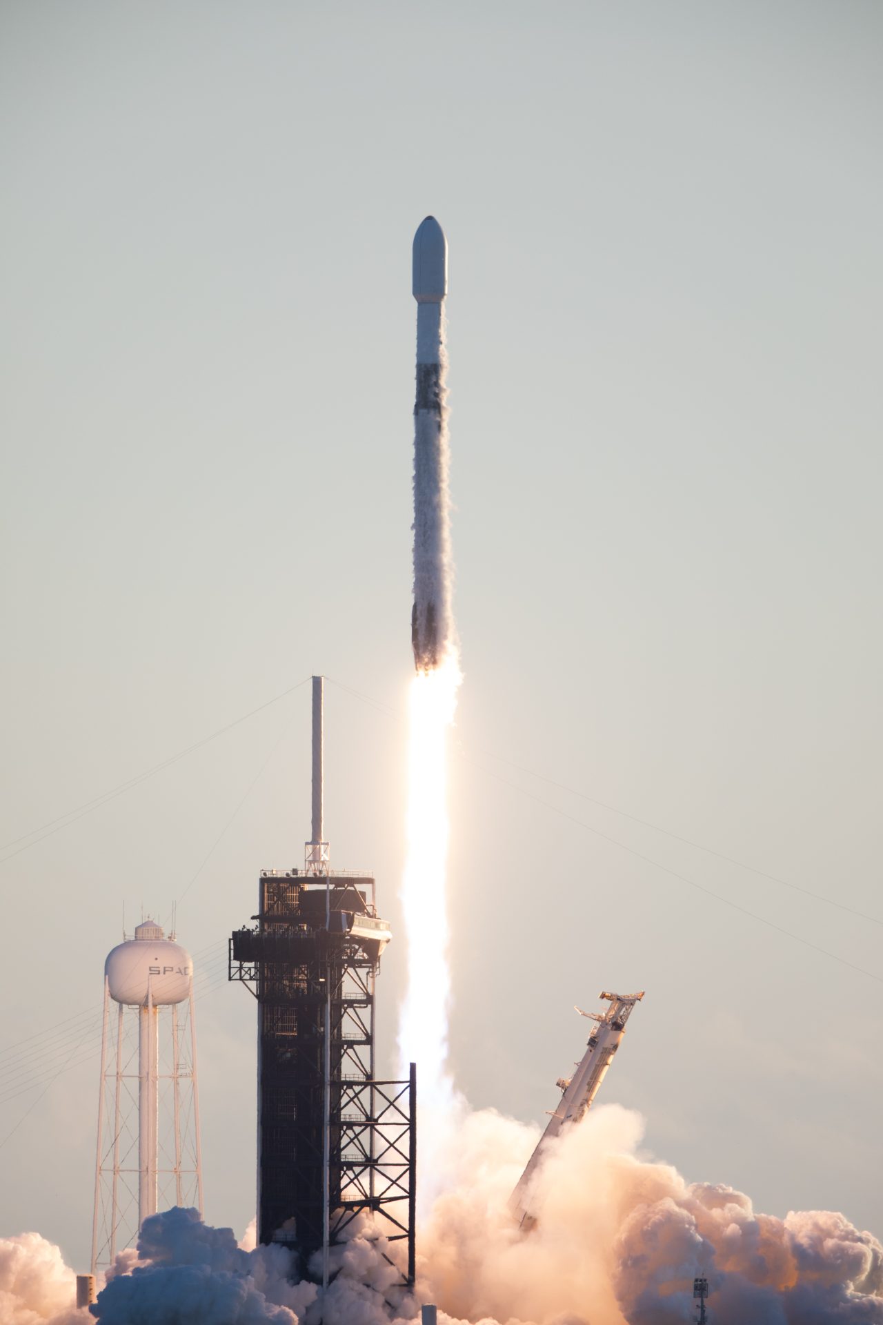
A SpaceX Falcon 9 rocket carrying NASA’s IMAP (Interstellar Mapping and Acceleration Probe), the agency’s Carruthers Geocorona Observatory, and National Oceanic and Atmospheric Administration’s (NOAA) Space Weather Follow On–Lagrange 1 (SWFO-L1) spacecraft lifts off from Launch Complex 39A at NASA’s Kennedy Space Center in Florida at 7:30 a.m. EDT Wednesday, Sept. 24, 2025. The missions will each focus on different effects of the solar wind — the continuous stream of particles emitted by the Sun — and space weather — the changing conditions in space driven by the Sun — from their origins at the Sun to their farthest reaches billions of miles away at the edge of our solar system.
Tag: NASA
-
3-in-1 Launch
 NASA/Kim Shiflett
A SpaceX Falcon 9 rocket lifts off from NASA’s Kennedy Space Center in Florida on Sept. 24, 2025, carrying three missions that will investigate the Sun’s influence across the solar system.
NASA’s IMAP (Interstellar Mapping and Acceleration Probe), the agency’s Carruthers Geocorona Observatory, and National Oceanic and Atmospheric Administration’s (NOAA) Space Weather Follow On–Lagrange 1 (SWFO-L1) spacecraft will each focus on different effects of the solar wind – the continuous stream of particles emitted by the Sun – and space weather – the changing conditions in space driven by the Sun – from their origins at the Sun to their farthest reaches billions of miles away at the edge of our solar system.
Image credit: NASA/Kim Shiflett
-
NASA-ISRO Satellite Sends First Radar Images of Earth’s Surface
 Captured on Aug. 21, this image from NISAR’s L-band radar shows Maine’s Mount Desert Island. Green indicates forest; magenta represents hard or regular surfaces, like bare ground and buildings. The magenta area on the island’s northeast end is the town of Bar Harbor.Credit: NASA/JPL-Caltech
The NISAR (NASA-ISRO Synthetic Aperture Radar) Earth-observing radar satellite’s first images of our planet’s surface are in, and they offer a glimpse of things to come as the joint mission between NASA and ISRO (Indian Space Research Organisation) approaches full science operations later this year.
“Launched under President Trump in conjunction with India, NISAR’s first images are a testament to what can be achieved when we unite around a shared vision of innovation and discovery,” said acting NASA Administrator Sean Duffy. “This is only the beginning. NASA will continue to build upon the incredible scientific advancements of the past and present as we pursue our goal to maintain our nation’s space dominance through Gold Standard Science.”
Images from the spacecraft, which was launched by ISRO on July 30, display the level of detail with which NISAR scans Earth to provide unique, actionable information to decision-makers in a diverse range of areas, including disaster response, infrastructure monitoring, and agricultural management.
“By understanding how our home planet works, we can produce models and analysis of how other planets in our solar system and beyond work as we prepare to send humanity on an epic journey back to the Moon and onward to Mars,” said NASA Associate Administrator Amit Kshatriya. “The successful capture of these first images from NISAR is a remarkable example of how partnership and collaboration between two nations, on opposite sides of the world, can achieve great things together for the benefit of all.”
On Aug. 21, the satellite’s L-band synthetic aperture radar (SAR) system, which was provided by NASA’s Jet Propulsion Laboratory in Southern California, captured Mount Desert Island on the Maine coast. Dark areas represent water, while green areas are forest, and magenta areas are hard or regular surfaces, such as bare ground and buildings. The L-band radar system can resolve objects as small as 15 feet (5 meters), enabling the image to display narrow waterways cutting across the island, as well as the islets dotting the waters around it.
Then, on Aug. 23, the L-band SAR captured data of a portion of northeastern North Dakota straddling Grand Forks and Walsh counties. The image shows forests and wetlands on the banks of the Forest River passing through the center of the frame from west to east and farmland to the north and south. The dark agricultural plots show fallow fields, while the lighter colors represent the presence of pasture or crops, such as soybean and corn. Circular patterns indicate the use of center-pivot irrigation.
 On Aug. 23, NISAR imaged land adjacent to northeastern North Dakota’s Forest River. Light-colored wetlands and forests line the river’s banks, while circular and rectangular plots throughout the image appear in shades that indicate the land may be pasture or cropland with corn or soy.Credit: NASA/JPL-Caltech
The images demonstrate how the L-band SAR can discern what type of land cover — low-lying vegetation, trees, and human structures — is present in each area. This capability is vital both for monitoring the gain and loss of forest and wetland ecosystems, as well as for tracking the progress of crops through growing seasons around the world.
“These initial images are just a preview of the hard-hitting science that NISAR will produce — data and insights that will enable scientists to study Earth’s changing land and ice surfaces in unprecedented detail while equipping decision-makers to respond to natural disasters and other challenges,” said Nicky Fox, associate administrator, Science Mission Directorate at NASA Headquarters in Washington. “They are also a testament to the years of hard work of hundreds of scientists and engineers from both sides of the world to build an observatory with the most advanced radar system ever launched by NASA and ISRO.”
The L-band system uses a 10-inch (25-centimeter) wavelength that enables its signal to penetrate forest canopies and measure soil moisture and motion of ice surfaces and land down to fractions of an inch, which is a key measurement in understanding how the land surface moves before, during, and after earthquakes, volcanic eruptions, and landslides.
The preliminary L-band images are an example of what the mission team will be able to produce when the science phase begins in November. The satellite was raised into its operational 464-mile (747-kilometer) orbit in mid-September.
The NISAR mission also includes an S-band radar, provided by ISRO’s Space Applications Centre, that uses a 4-inch (10-centimeter) microwave signal that is more sensitive to small vegetation, making it effective at monitoring certain types of agriculture and grassland ecosystems.
The spacecraft is the first to carry both L- and S-band radars. The satellite will monitor Earth’s land and ice surfaces twice every 12 days, collecting data using the spacecraft’s drum-shaped antenna reflector, which measures 39 feet (12 meters) wide — the largest NASA has ever sent into space.
The NISAR mission is a partnership between NASA and ISRO spanning years of technical and programmatic collaboration. The successful launch and deployment of NISAR builds on a strong heritage of cooperation between the United States and India in space.
The Space Applications Centre provided the mission’s S-band SAR. The U R Rao Satellite Centre provided the spacecraft bus. The launch vehicle was provided by Vikram Sarabhai Space Centre, and launch services were through Satish Dhawan Space Centre. Key operations, including boom and radar antenna reflector deployment, are now being executed and monitored by the ISRO Telemetry, Tracking and Command Network’s global system of ground stations.
Managed by Caltech in Pasadena, NASA JPL leads the U.S. component of the project. In addition to the L-band SAR, reflector, and boom, JPL also provided the high-rate communication subsystem for science data, a solid-state data recorder, and payload data subsystem. NASA’s Goddard Space Flight Center in Greenbelt, Maryland, manages the Near Space Network, which receives NISAR’s L-band data.
To learn more about NISAR, visit:
-end-
Liz Vlock
Headquarters, Washington
202-358-1600
elizabeth.a.vlock@nasa.govAndrew Wang / Jane J. Lee
Jet Propulsion Laboratory, Pasadena, Calif.
626-379-6874 / 818-354-0307
andrew.wang@jpl.nasa.gov / jane.j.lee@jpl.nasa.gov -
NASA & STEM Learning Ecosystems: Opportunities & Benefits for Everyone
2 min read
NASA & STEM Learning Ecosystems: Opportunities & Benefits for Everyone
STEM learning ecosystems are intentionally designed, community-wide partnerships that enable all Americans to actively participate in science, technology, engineering, and math (STEM) throughout their lifetimes. Lifelong STEM learning helps people build critical knowledge and skills, access economic opportunities, drive innovation, and make informed decisions in a changing world. STEM learning ecosystems draw on expertise and resources to provide access to these benefits for the entire community.
NASA’s Science Activation (SciAct) program, a competitively-selected network of collaborative projects that connect NASA science with people of all ages and backgrounds, includes new and growing STEM learning ecosystems in American communities from Alaska to Maine and creates free, high-quality resources that educators across the country can use to share the excitement of Earth and space science.
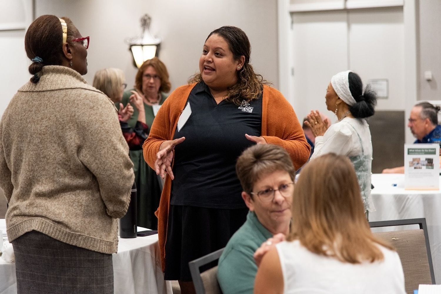
To further support connections among STEM learning ecosystems and NASA, the SciAct STEM Ecosystems project held a meeting in Saint Paul, Minnesota on August 4-6, 2025. Approximately 100 educators, evaluators, subject matter experts, and other STEM learning facilitators from around the nation participated to share approaches, learn about resources, and build relationships. The gathering offered an opportunity to connect NASA SciAct teams with each other and with external networks and learning ecosystems for mutual benefit.
Meeting goals included sharing ways to create effective partnerships and engage learners in Earth and space science, discovering NASA resources and assets to use in STEM education efforts, and strengthening connections among participants. To accomplish these goals, meeting activities included plenaries, breakout sessions, and networking opportunities.
Led by Arizona State University, the SciAct STEM Ecosystems project is a collaboration among several regional partnerships/SciAct project teams: Arctic and Earth SIGNs, Learning Ecosystems Northeast, Rural Activation and Innovation Network, and the Smoky Mountains STEM Collaborative. The project also partners with the National Informal STEM Education Network to create professional resources.
For those who were unable to attend in person, the STEM Ecosystems project makes a variety of resources available online: https://www.nisenet.org/stem-learning-ecosystems.
SciAct STEM Ecosystems is supported by NASA under cooperative agreement award number 80NSSC21M0007 and is part of NASA’s Science Activation Portfolio. Learn more about how Science Activation connects NASA science experts, real content, and experiences with community leaders to do science in ways that activate minds and promote deeper understanding of our world and beyond: https://science.nasa.gov/learn/about-science-activation/.
 Meeting participants took advantage of opportunities to network and strengthen their relationships.Emily Maletz/NISE Network
Share
Details
Last UpdatedSep 25, 2025EditorNASA Science Editorial TeamRelated Terms
Explore More
-
NASA Astronaut Chris Williams to Discuss Upcoming Launch, Mission
 NASA astronaut Chris Williams poses for an official portrait at the agency’s Johnson Space Center in Houston.Credit: NASA
NASA will host a news conference at 2 p.m. EDT Wednesday, Oct. 1, from the agency’s Johnson Space Center in Houston to highlight the upcoming mission of astronaut Chris Williams to the International Space Station.
The news conference will stream live on NASA’s website and YouTube channel. Learn how to watch NASA content through a variety of platforms, including social media.
The Soyuz MS-28 spacecraft, targeted to launch Nov. 27 from the Baikonur Cosmodrome in Kazakhstan, will carry Williams on his first flight, as well as Sergey Kud-Sverchkov and Sergey Mikaev of Roscosmos, to the space station for an eight-month mission as part of Expeditions 73/74.
Media interested in participating must contact the newsroom at NASA Johnson no later than 5 p.m., Monday, Sept. 29, at 281-483-5111 or jsccommu@mail.nasa.gov. A copy of NASA’s media accreditation policy is online. Media interested in participating by phone must contact the Johnson newsroom by 10 a.m. the day of the event.
Selected as a candidate in 2021, Williams graduated with the 23rd astronaut class in 2024. He began training for his first space station flight assignment immediately after completing initial astronaut candidate training.
Williams was born in New York City, and considers Potomac, Maryland, his hometown. He holds a bachelor’s degree in physics from Stanford University in California and a doctorate in physics from the Massachusetts Institute of Technology in Cambridge, where his research focused on astrophysics. Williams completed medical physics residency training at Harvard Medical School in Boston. He was working as a clinical physicist and researcher at the Brigham and Women’s Hospital in Boston when he was selected as an astronaut candidate.
The International Space Station is a convergence of science, technology, and human innovation enabling research not possible on Earth. For nearly 25 years, NASA has supported a continuous U.S. human presence aboard the orbiting laboratory, where astronauts have learned to live and work in space for extended periods of time. The space station is a springboard for developing a low Earth economy and NASA’s next great leaps in human exploration at the Moon under the Artemis campaign and Mars.
Learn more about the International Space Station:
https://www.nasa.gov/international-space-station
-end-
Jimi Russell / Joshua Finch
Headquarters, Washington
202-358-1100
james.j.russell@nasa.gov / joshua.a.finch@nasa.govShaneequa Vereen
Johnson Space Center, Houston
281-483-5111
shaneequa.y.vereen@nasa.gov -
NASA Glenn Reinforces Role in Aerospace Innovation During Ohio Space Week
 Left to right: Moderator Brian Miske, Americas Space Leader, KPMG radio, with panelists Amit Kshatriya, NASA associate administrator; Jacki Cortese, senior director, Civil Space: Blue Origin; and Robert Lightfoot, president, Lockheed Martin Space (former NASA associate administrator) discuss balancing innovation, risk, and readiness in space during the Ohio Space Forum.Credit: NASA/Jef Janis
Ohio Space Week, Sept. 8–13, highlighted the state’s aerospace legacy and the role NASA’s Glenn Research Center has in advancing space technology.
The week kicked off with the American Astronautical Society’s Glenn Space Technology Symposium, Sept. 8–10, hosted by Case Western Reserve University. Experts, students, and industry leaders gathered to discuss emerging space technologies. NASA Glenn Director Dr. Jimmy Kenyon delivered opening remarks, and astronaut Doug “Wheels” Wheelock gave a keynote on his spaceflight experience.
On Sept. 11, Team NEO hosted the Sixth Annual Ohio Space Forum at NASA Glenn, bringing together leaders from aerospace, government, academia, and research. The forum spotlighted Ohio’s leadership in space innovation, including advances in nuclear electric and nuclear thermal propulsion. Key participants included NASA Associate Administrator Amit Kshatriya, astronaut Sunita “Suni” Williams, several local and state officials, and other community partners. 3News Chief Meteorologist Betsy Kling emceed the event.
The City Club of Cleveland welcomed astronauts Williams and Wheelock for a presentation to the local community, Sept. 11, and Cleveland Guardians fans cheered as Williams threw out the first pitch during the game at Progressive Field later that day.
 NASA Glenn experts conduct a wind tunnel demonstration using a portable wind tunnel for visitors during Discovery Days at Great Lakes Science Center in Cleveland on Friday, Sept. 12, 2025.Credit: NASA/Lily Hammel
 Visitors view items that are part of the “Evolution of the Spacesuit” exhibit during Discovery Days at Great Lakes Science Center in Cleveland on Friday, Sept. 12, 2025.Credit: NASA/Lily Hammel
 Astronaut Sunita Williams has fun on the sidelines before she throws out the first pitch prior to a Guardians game at Progressive Field in Cleveland on Thursday, Sept. 11, 2025.Credit: NASA/Lily Hammel
 A family takes a photo with Astronaut Doug Wheelock during Discovery Days at Great Lakes Science Center in Cleveland on Friday, Sept. 12, 2025.Credit: NASA/Lily Hammel
 Two young visitors at Discovery Days at Great Lakes Science Center in Cleveland on Friday, Sept. 12, 2025, share the NASA spotlight.Credit: NASA/Lily Hammel
 Guests interact with several aeronautics-focused exhibits in the Great Lakes Science Center promenade area on Friday, Sept. 12, 2025, during Discovery Days.Credit: NASA/Lily Hammel
 NASA Astronauts Doug Wheelock, left, and Sunita Willams at The City Club of Cleveland luncheon on Thursday, Sept. 11, 2025. NASA Glenn Center Director Dr. Jimmy Kenyon stands at the podium and addresses the audience.Credit: NASA/Lily Hammel
 Using the Lunar Habitat Power Grid model, NASA Glenn Research Center experts demonstrate how payloads will need power to achieve a viable human presence on the Moon during Discovery Days at Great Lakes Science Center in Cleveland on Friday, Sept. 12, 2025.Credit: NASA/Lily Hammel
 NASA Glenn Research Center’s astronaut mascot stands behind the NASA worm logo during Discovery Days at Great Lakes Science Center in Cleveland on Friday, Sept. 12, 2025.Credit: NASA/Lily Hammel
 During Discovery Days at Great Lakes Science Center in Cleveland on Friday, Sept. 12, NASA Glenn Research Center experts share with visitors about primary fuel cells, which convert propellants into electricity, and regenerative fuel cells, which store electrical energy like rechargeable batteries.Credit: NASA/Lily Hammel
 Astronaut Sunita Williams talks with students in Great Lakes Science Center’s DOME Theater during Discovery Days in Cleveland on Friday, Sept. 12, 2025.Credit: NASA/Lily Hammel
 Left to right: Moderator Brian Miske, Americas Space Leader, KPMG radio, with panelists Amit Kshatriya, NASA associate administrator; Jacki Cortese, senior director, Civil Space: Blue Origin; and Robert Lightfoot, president, Lockheed Martin Space (former NASA associate administrator) discuss balancing innovation, risk, and readiness in space during the Ohio Space Forum.Credit: NASA/Jef Janis
Discovery Days, the capstone of Ohio Space Week, welcomed nearly 5,000 visitors to Cleveland’s Great Lakes Science Center — home of the NASA Glenn Visitor Center — on Sept. 12–13. This immersive event brought NASA beyond its gates and into the community, offering the public a firsthand look at major missions and cutting-edge technology.
Visitors explored interactive demonstrations and exhibits led by NASA Glenn experts, highlighting innovations that support NASA’s Artemis missions and future exploration of Mars and beyond, including developments in power, propulsion, and communications.
The astronauts were on hand during Discovery Days to talk with students and guests – inspiring the next generation of explorers through direct engagement and storytelling.
From the Wright brothers’ first flight to pioneering advancements in space exploration, Ohio has been at the forefront of aerospace innovation for generations. Ohio Space Week celebrated these deep-rooted contributions to the aeronautics and space industries, highlighting the people, institutions, and businesses that continue to shape the future of flight and exploration.
-
NASA Glenn’s AeroSpace Frontiers Newsletter Takes a Bow

3 min read
Preparations for Next Moonwalk Simulations Underway (and Underwater)
Since April 1999, the AeroSpace Frontiers (AF) newsletter has shared information monthly on NASA Glenn Research Center’s people, projects, and progress. If you were looking for news on any of these topics, there was a good chance you could read all about them in AF each month.
The newsletter has evolved in the last 26 years, changing with the times, to improve how and when we communicate with our audiences. From updating the hard copy layout to offering the issue online, we adjusted and enhanced AF to meet our customers’ needs.
As methods of sharing news and information are now available that allow us to reach you sooner, we are shifting our focus to these platforms and discontinuing our monthly newsletter. This September issue will be our last.
We hope you’ll stay connected with us through our official website and social media channels: Facebook, X, Instagram, LinkedIn, and YouTube. We thank you for your readership!
Before closing, we want to celebrate and reflect on the newsletter’s remarkable tenure (and interesting names) over the years.
 Credit: NASA
The Story Behind the Name: A Look Back
While the center published a newsletter continually (with a brief pause in the early 1960s) since its opening in 1942, its name, layout, and content evolved over the decades. It began in 1942 as Wing Tips, an internal biweekly newsletter, and was later renamed Orbit in October 1958 as the National Advisory Committee for Aeronautics transitioned to NASA. In 1961, the center paused the newsletter’s publication to focus its resources on the early space program.
The publication reemerged in 1964 as Lewis News and expanded to a larger newsletter format in 1969, in conjunction with the Apollo 11 Moon landing. This format continued until 1995, when Lewis News moved to a monthly schedule with expanded, but physically smaller, issues as part of an overall effort to reduce spending.
Then, in 1999 – prior to the center being renamed NASA’s John H. Glenn Research Center – employees and center management were surveyed for a new newsletter title that would not be tied to future changes in research activities or center names. The group selected AeroSpace Frontiers to represent the modernization of the newsletter’s appearance and its expanded subject matter. It was now a monthly news magazine that included a variety of graphics and photographs, as well as additional content that addressed audiences beyond the center.
About Our Amazing Editor
 Portrait of editor Doreen Zudell, taken in 1990 at NASA’s Glenn Research Center in Cleveland. At that time, the center newsletter was known as Lewis News.Credit: NASA
Doreen Zudell has served as the editor of AeroSpace Frontiers (AF) since the first issue in 1999 and has been a driving force behind the publication ever since. In addition to writing and editing stories each month, she also has navigated many format changes over the years.
 Editor Doreen Zudell interviews NASA astronaut Doug Wheelock at NASA’s Glenn Research Center in Cleveland in 2019.Credit: NASA/Marvin Smith
“We appreciate Doreen’s knowledge, experience, and passion for sharing Glenn’s news and accomplishments with AF readers,” said NASA Glenn Office of Communications Director Kristen Parker. “Her compassion, journalistic flair, and dedication to putting employees’ needs first is evident in everything she does.”
-
Glenn Highlights Space Exploration at Minnesota State Fair
1 min read
Preparations for Next Moonwalk Simulations Underway (and Underwater)
 Visitors at the Minnesota State Fair get an up-close look at a Moon rock on Friday, Aug. 22, 2025.Credit: NASA/Christopher Richards
NASA brought the excitement of space exploration to the Minnesota State Fair from Aug. 21–24, offering exhibits and interactive experiences for the whole family. Led by NASA’s Glenn Research Center in Cleveland, the agency showcased the future of space exploration and the technologies making it possible — from next-generation spacesuits to the Artemis missions that will return humans to the Moon.
A major attraction was Glenn’s “Suits and Boots” exhibit, along with an Apollo 15 Moon rock, which drew large crowds to the North End Event Center. Glenn staff, joined by Mike Lammers, deputy chief of the Flight Director’s Office at NASA’s Johnson Space Center in Houston, engaged with both media and fairgoers to highlight spacesuit advancements, Glenn’s unique role as the only NASA center in the Midwest, and upcoming plans for returning to the Moon and journeying to Mars through Artemis.
 Mike Lammers, Minnesota native and deputy chief of the Flight Director’s Office at NASA’s Johnson Space Center in Houston, talks with visitors at the Minnesota State Fair on Friday, Aug. 22, 2025.Credit: NASA/Christopher Richards
The team reached an estimated 57,000 people directly, with additional exposure through traditional and social media efforts.
-
NASA Names Glenn’s Steven Sinacore to Lead Fission Surface Power
 Steven SinacoreCredit: NASA
NASA leadership has named NASA Glenn Research Center’s Steven A. Sinacore as the agency’s program executive for Fission Surface Power with Lindsay Kaldon as deputy program executive.
Sinacore will lead a team within the Exploration Systems Development Mission Directorate dedicated to advancing fission surface power technology in support of lunar exploration, providing high power energy generation on Mars, and strengthening national security.
 Lindsay KaldonCredit: NASA
Sinacore has more than 20 years of leadership and project management experience. Most recently, he served as director of Aeronautics at NASA Glenn in Cleveland. Prior to that, he was deputy project manager of the Gateway Power and Propulsion Element. After joining NASA Glenn in 2005, Sinacore held numerous systems engineering, project management, and mission operations positions, and he has been instrumental in developing and executing intergovernmental partnerships.
His strong background leading cross-agency teams, combined with NASA Glenn’s longstanding expertise in space power technology development, will equip the agency to further advance U.S. competition and lunar surface leadership under the Artemis campaign.
Last month, NASA declared its intent to put a system that would provide at least 100 kilowatts of electrical power on the Moon by fiscal year 2030. NASA then surveyed industry for their interest and feedback on an announcement for partnership proposals.
This new effort builds on previous Glenn-led work to advance fission surface power technology development and concept designs.
-
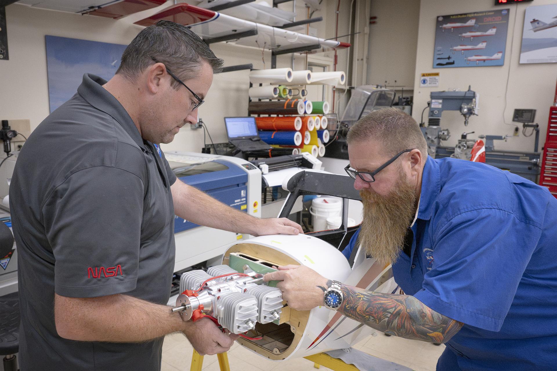
NASA Lab Builds New Aircraft to Support Complex Flight Research
2 min read
Preparations for Next Moonwalk Simulations Underway (and Underwater)
 Justin Link, left, and Justin Hall attach an engine onto a subscale aircraft on Wednesday, Sept. 3, 2025, at NASA’s Armstong Flight Research Center in Edwards, California. Link is a pilot for small uncrewed aircraft systems at the center’s Dale Reed Subscale Flight Research Laboratory and Hall is the lab’s chief pilot.NASA/Christopher LC Clark
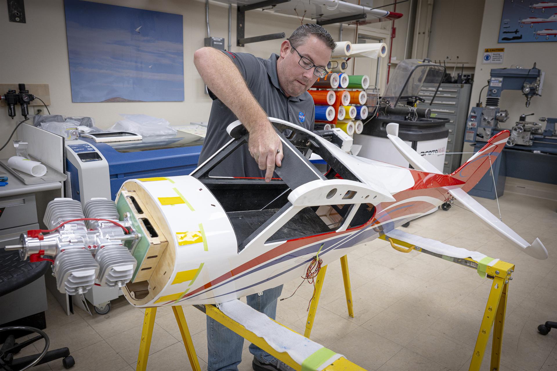 Justin Link turns a subscale aircraft on its side to continue work to mark where the engine cowl will go and where to line it up for attachment on Wednesday, Sept. 3, 2025, at NASA’s Armstong Flight Research Center in Edwards, California. Link is a pilot for small uncrewed aircraft systems at the center’s Dale Reed Subscale Flight Research Laboratory.NASA/Christopher LC Clark
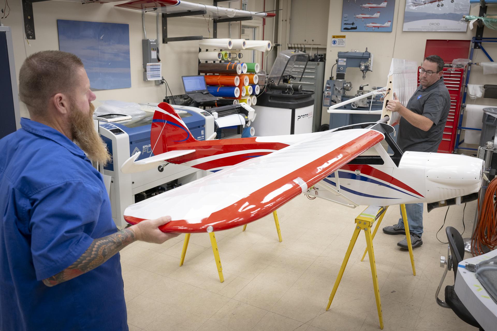 Justin Hall, left, and Justin Link attach the wings onto a subscale aircraft on Wednesday, Sept. 3, 2025, at NASA’s Armstong Flight Research Center in Edwards, California. Hall is chief pilot at the center’s Dale Reed Subscale Flight Research Laboratory and Link is a pilot for small uncrewed aircraft systems.NASA/Christopher LC Clark
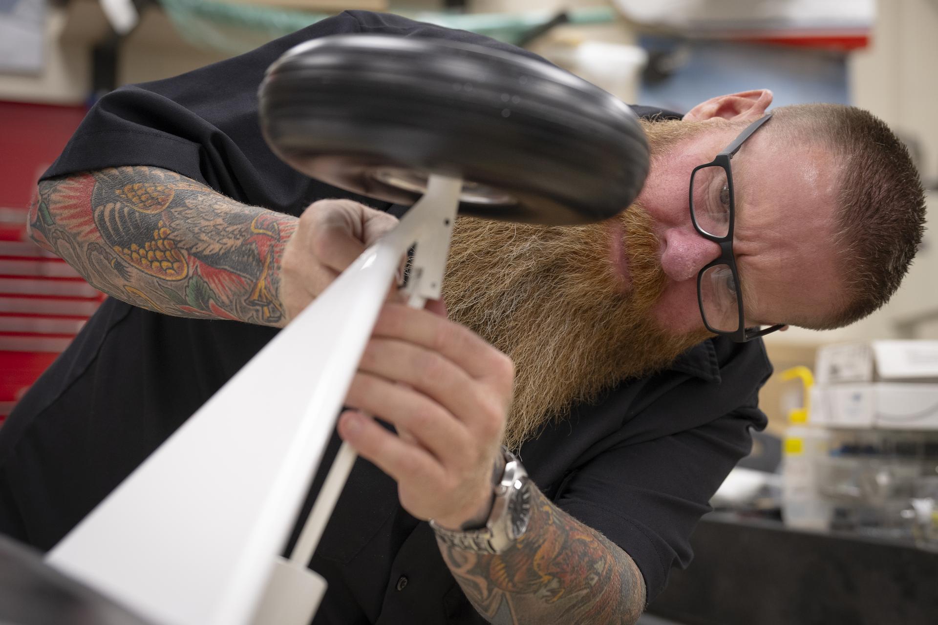 Justin Hall attaches part of the landing gear of a subscale aircraft on Friday, Sept. 12, 2025, at NASA’s Armstong Flight Research Center in Edwards, California. Hall is the chief pilot at the center’s Dale Reed Subscale Flight Research Laboratory.NASA/Christopher LC Clark
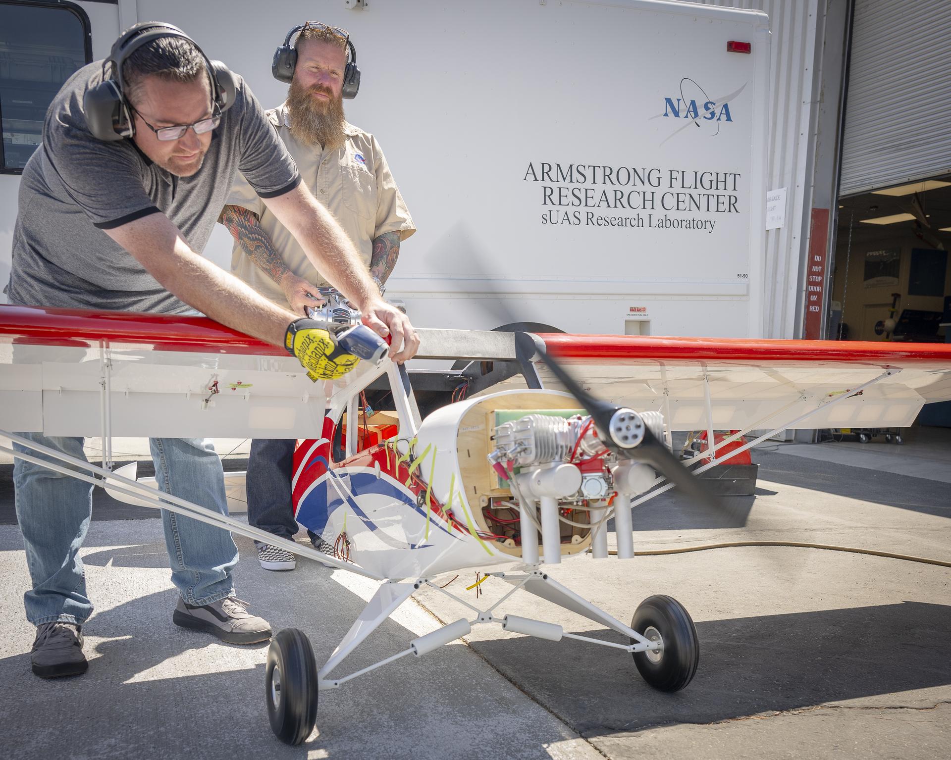 Justin Link, left, holds the subscale aircraft in place, while Justin Hall manages engine speed during preliminary engine tests on Friday, Sept. 12, 2025, at NASA’s Armstong Flight Research Center in Edwards, California. Link is a pilot for small uncrewed aircraft systems at the center’s Dale Reed Subscale Flight Research Laboratory and Hall is the chief pilot.NASA/Christopher LC Clark
NASA’s Armstrong Flight Research Center in Edwards, California, is building a new subscale aircraft to support increasingly complex flight research, offering a more flexible and cost-effective alternative to crewed missions.
The aircraft is being built by Justin Hall, chief pilot at NASA Armstrong’s Dale Reed Subscale Flight Research Laboratory, and Justin Link, a small uncrewed aircraft pilot. The duo is replacing the center’s aging MicroCub subscale aircraft with a more capable platform that will save time and reduce costs. The new aircraft spans about 14 feet from wingtip to wingtip, measures nine-and-a-half feet long, and weighs about 60 pounds.
The subscale laboratory accelerates innovation by using small, remotely piloted aircraft to test and evaluate new aerodynamic concepts, technologies, and flight control systems. Named after aerospace pioneer Dale Reed, the lab enables rapid prototyping and risk reduction before transitioning to full-scale or crewed flight testing. Its work plays a key role in increasing technology readiness to support NASA’s missions on Earth and beyond.
Hall and Link are modifying an existing subscale aircraft kit by adding a more powerful engine, an autopilot system, instrumentation, and a reinforced structure. The aircraft will offer greater flexibility for flight experiments, enabling more frequent and affordable testing compared to crewed aircraft.
One example of its potential is the Robust Autonomous Aerial Recapture project, which uses sensors and video with advanced programming to learn and adapt for mid-air capture. The system relies on a magnetic connection mechanism integrated onto the two aircraft.
This capability could support future science missions in which a mothership deploys drones to collect samples, recharge, and redeploy for additional missions, saving fuel, reducing cost, and increasing efficiency. Aerial recapture work is funded by the NASA Armstrong Center Innovation Fund and the Space Technology Mission Directorate.
Share
Related Terms
Explore More
-
NASA Aircraft Coordinate Science Flights to Measure Air Quality
4 min read
NASA Aircraft Coordinate Science Flights to Measure Air Quality
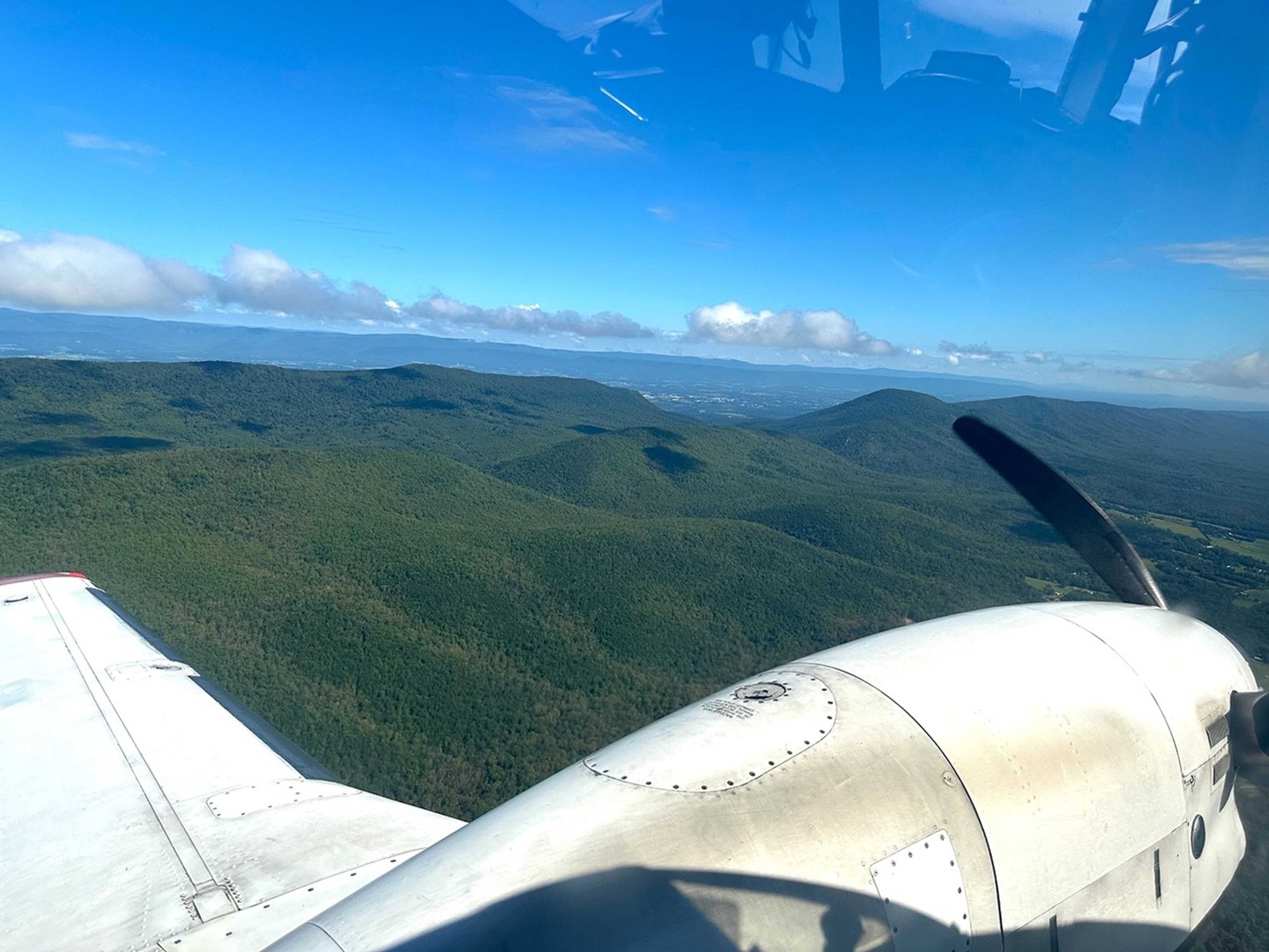
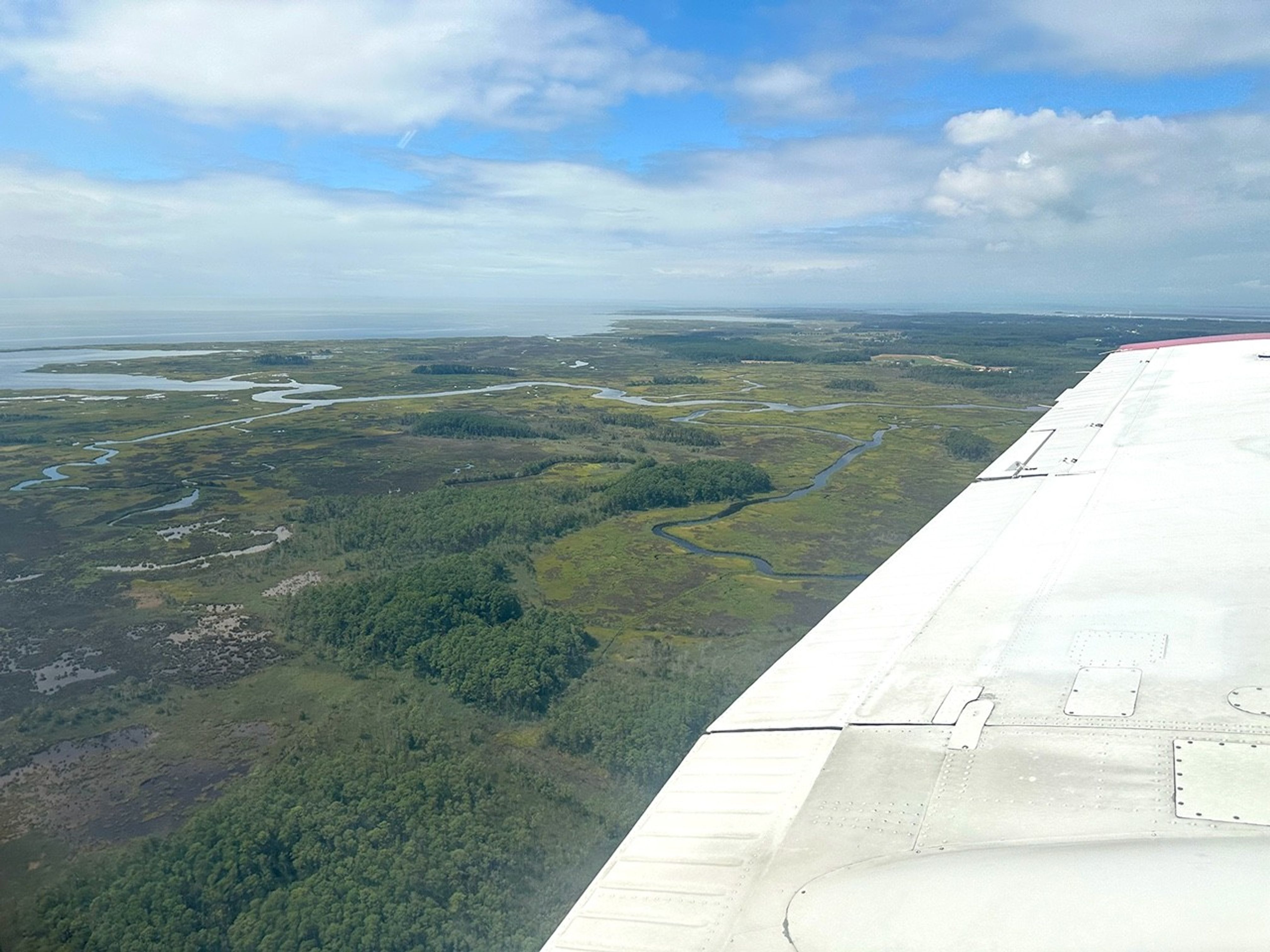 NASA Goddard’s G-LiHT flying on the A90 flies over Shenandoah Valley in the US East Coast during the week of August 11-15.Credit: Shawn Serbin/NASA GSFC
Magic is in the air. No wait… MAGEQ is in the air, featuring scientists from NASA centers across the country who teamed up with the National Oceanic and Atmospheric Administration (NOAA), the University of Maryland Baltimore County, and several other university and government partners and collaborators.
This summer, six planes collectively flew more than 400 hours over the mid-Atlantic United States with a goal of gathering data on a range of objectives, including air quality, forestry, and fire management.
This was part of an effort called MAGEQ, short for Mid-Atlantic Gas Emissions Quantification. Rather than one mission, MAGEQ consists of several individual missions across more than a dozen organizations and agencies, along with university students. Over the course of around six weeks, aircraft flew over cities, wetlands, farms, and coal mining areas.
 NASA Goddard’s G-LiHT flying on the A90 flies over the Chesapeake Bay near the Big Annemessex River.Credit: Shawn Serbin/NASA GSFC
“Each aircraft team is comprised of highly skilled and motivated people who understand how to fly their particular plane to achieve the science they want,” said Glenn Wolfe, research scientist at NASA’s Goddard Space Flight Center in Greenbelt, Maryland, and project lead for MAGEQ. “The complexity comes in identifying how each platform can complement or supplement the others.”
Coordinating flights required both advanced planning and flexibility to get the best outcome. Weather proved to be a primary challenge for the team, as members worked around cloudy days, wind, and storms to ensure safe flights.
The six aircraft had different objectives and requirements. For example, some carried instruments that needed to fly high to simulate a satellite’s view of the atmosphere and the Earth’s surface and could not measure through clouds. Others were equipped with instruments that directly measured the air particles and could work under the clouds, provided there was no rain.
Despite weather challenges, flight teams worked together to coordinate as many multi-aircraft flight days as possible, meeting the overall objective of the MAGEQ campaign.
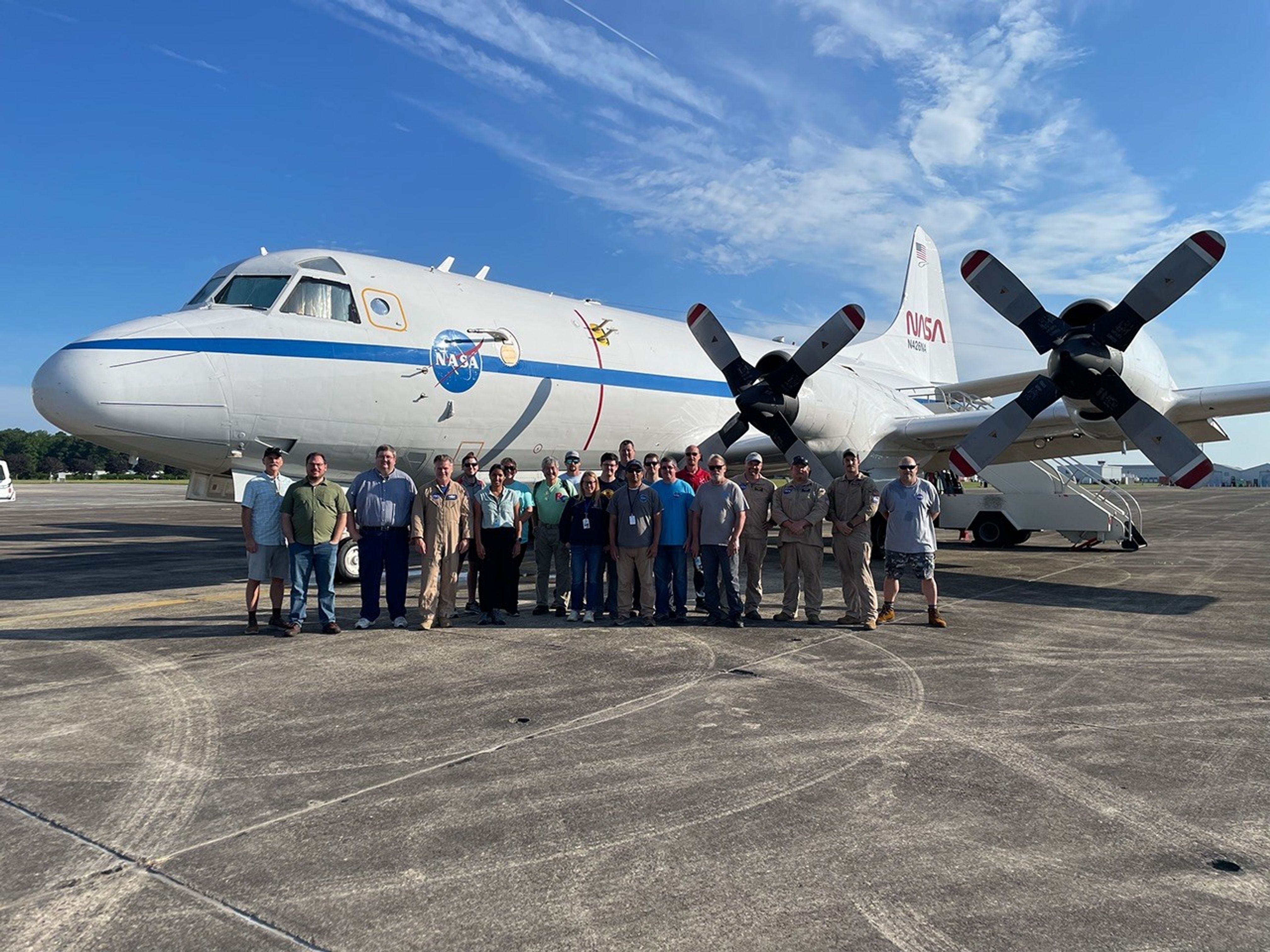 The MAGEQ team members pose in front of the P-3 aircraft.Credit: Roy Johnson/NASA
“It’s been inspiring to see how everybody worked together,” said Lesley Ott, research meteorologist and lead carbon cycle modeler for NASA’s Global Modeling and Assimilation Office at NASA Goddard. “By collecting data together, not only can we do a better job as scientists in having more complete understanding, we can also do a better job making usable data sets that meets the needs of different stakeholders.”
State resource managers in North Carolina and Virginia, for example, could benefit from this data as they monitor the health of wetlands, which provide resilience to storms, absorb carbon from the atmosphere and support local tourist industries. The data could also help operators at energy-producing facilities detect methane leaks or equipment failures quickly. Faster detection could speed up intervention and minimize waste, as well as lessen environmental impacts. Stakeholders were an integral part of the planning process, Ott said. They made suggestions about measurement sites and data needs that informed the flight planning.
Scientists will also use the measurements to verify satellite data from both public and commercial data providers. Satellites like the Tropospheric Emissions: Monitoring of Pollution (TEMPO) instrument collect similar data. Scientists can compare the airborne and satellite data to get a more complete picture of the atmosphere. They also will use MAGEQ data to evaluate atmospheric chemistry modeling from the Goddard Earth Observing System (GEOS) model, which connects atmospheric, oceanic, and land data to help create a more comprehensive picture of Earth science.
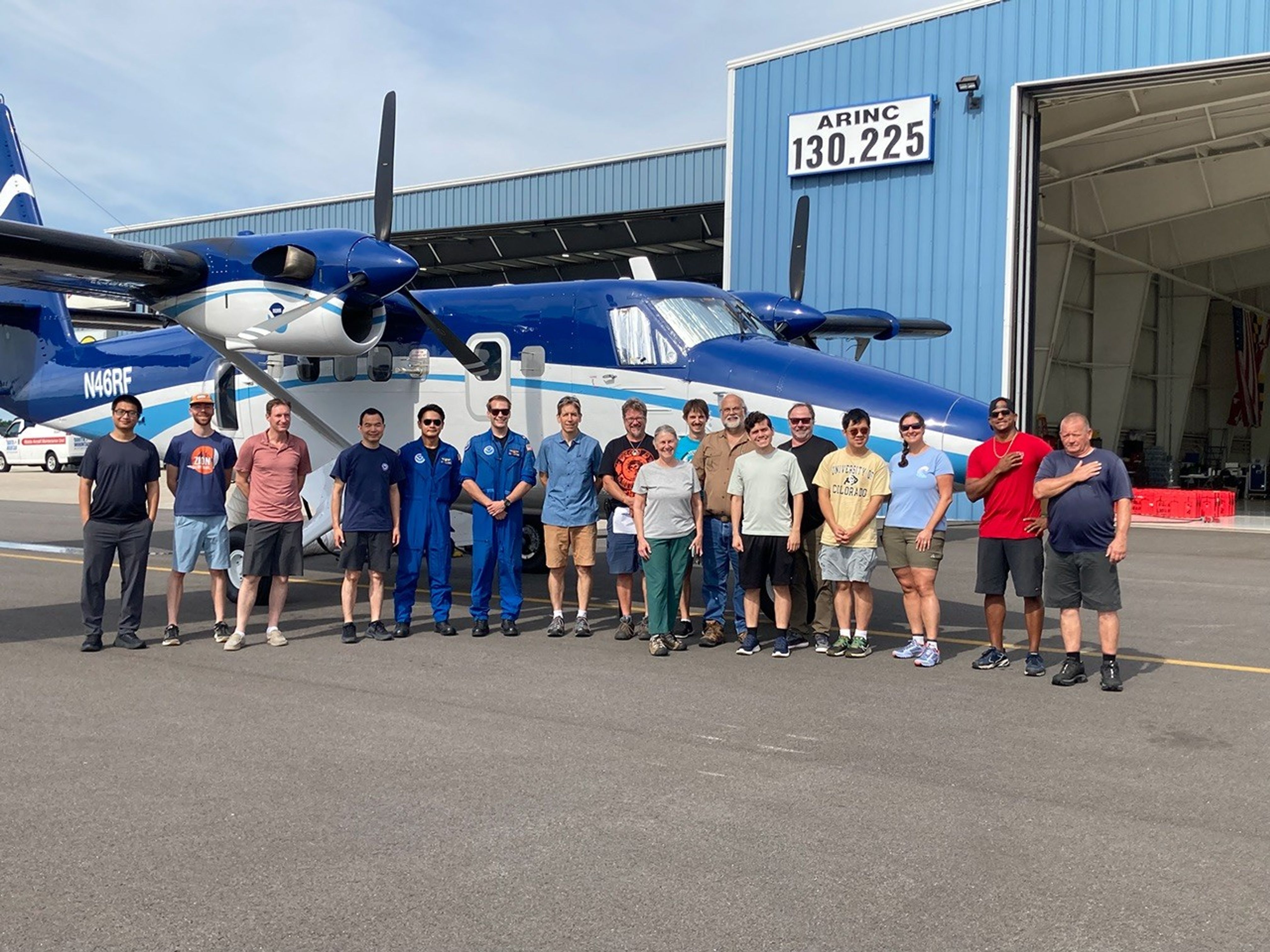 The MAGEQ team members from NOAA and NASA pose in front of the Twin Otter aircraft.Credit: Steve Brown
“Every aircraft does something different and contributes a different type of data,” said Steve Brown, leader of the tropospheric chemistry and atmospheric remote sensing programs at the NOAA Chemical Sciences Laboratory in Boulder, Colorado. “We’re going to have a lot of work to do at the end of this to put all these data sets together, but we will make the best use of all these measurements.”
NASA’s Goddard Space Flight Center, Greenbelt, Md.
Share
Details
Last UpdatedSep 24, 2025EditorJenny MarderContactErica McNameeLocationGoddard Space Flight CenterRelated Terms
Explore More
-
NASA Data Powers New Tool to Protect Water Supply After Fires
6 Min ReadNASA Data Powers New Tool to Protect Water Supply After Fires
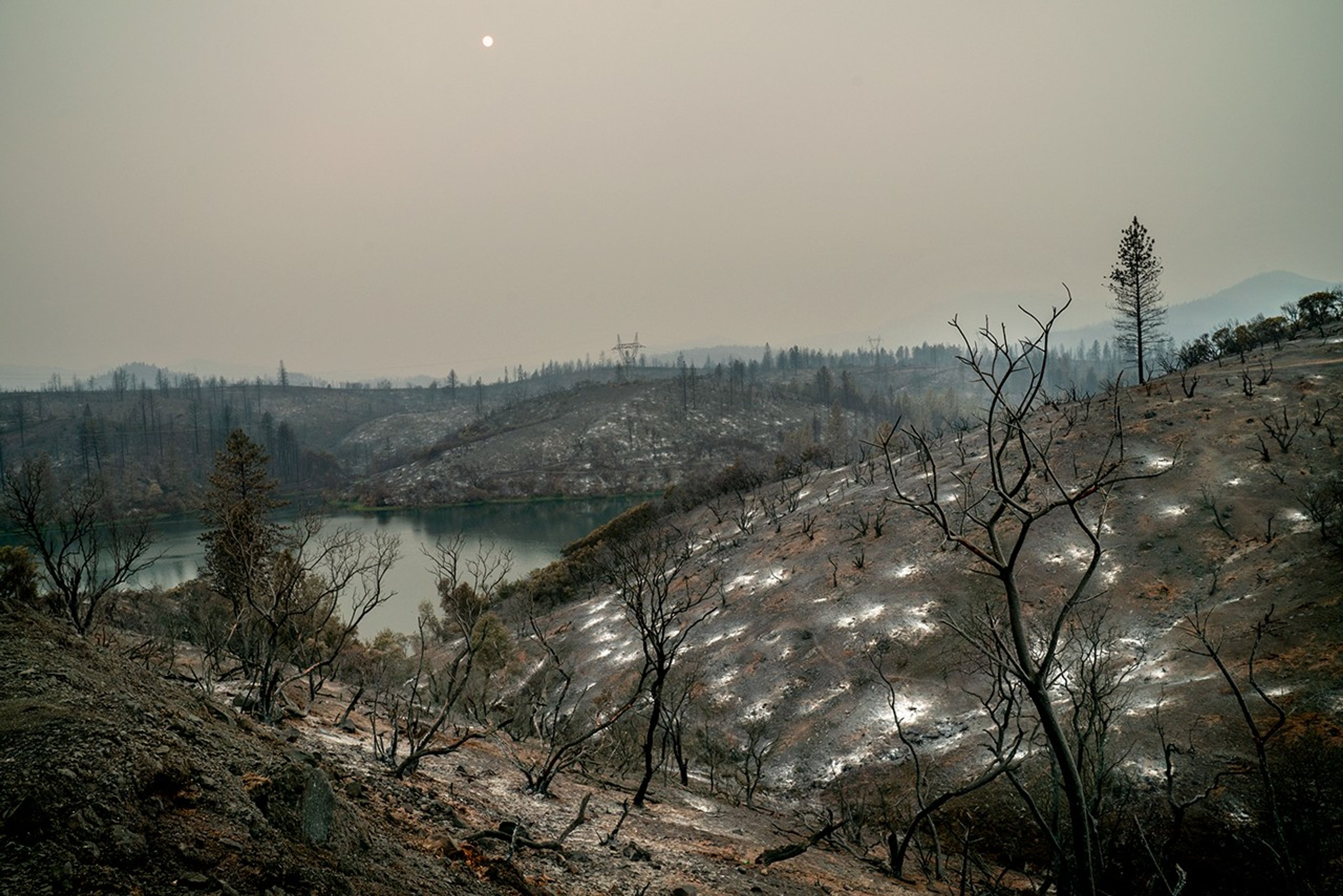
Wildfire-scorched terrain above a water body underscores risks to downstream supplies. Credits:
USFS/Cecilio RicardoWhen wildfires scorch a landscape, the flames are just the beginning. NASA is helping communities across the nation foresee and prepare for what can follow: mudslides, flash flooding, and contaminated surface water supplies.
A new online tool called HydroFlame, built with support from NASA’s Earth Science Division, relies on satellite data, hydrologic modeling, and artificial intelligence to predict how wildfires could affect water resources, from tap water to the rivers and streams where people fish. The project is being developed with the University of Texas at Arlington, Purdue University, the U.S. Geological Survey, and other partners.
For now, the tool includes data only for Montana’s Clark Fork Basin, where it is being piloted. But new applications are underway in California and Utah. Researchers will soon begin fieldwork in Los Angeles County to collect on-the-ground data to refine HydroFlame’s predictive approach — an important step toward expanding it beyond the pilot site.
“As wildfires intensify across the country, so do their ripple effects on regional water resources,” said Erin Urquhart, program manager for NASA’s water resources program at NASA Headquarters in Washington. “HydroFlame could help communities in the U.S. see what’s coming and plan for it, before a fire becomes a water crisis.”
That kind of foresight is exactly what local officials are looking for.
“For someone managing a trout fishery or drinking water supply, knowing when a stream might be overwhelmed with debris after a fire can mean the difference between preparedness and a crisis,” said Morgan Valliant, who is part of the project’s advisory group and the associate director of ecosystem services for Missoula Parks and Recreation in Montana. “This tool could let us move from reacting to planning.”
When fire reshapes land
In the wake of a wildfire, charred hillsides are often unstable. With the protective blanket of plants burned away, rain that once soaked gently into the soil can race downhill, sending ash, debris, and sediment into rivers and reservoirs. That runoff can trigger flash floods and contaminate drinking water.
Severe wildfires can also bake soil into a water-repelling crust. With less absorption, the same slopes can swing from drought to destructive floods, and those runoff risks can persist for decades.
HydroFlame, developed by a team led by Adnan Rajib at the University of Texas at Arlington, is built to anticipate those extremes.
“NASA is constantly pushing the boundaries when it comes to sensing and predicting fire,” Rajib said. “But there is still a huge gap when it comes to translating that fire information in terms of water. That’s where HydroFlame comes in.”
The tool will include three components:
- a historical viewer that maps past fire impacts on streamflow and sediment
- a “what-if” scenario builder to simulate future fires
- a predictive tool that generates weekly forecasts using near-real-time satellite data as initial conditions
When a wildfire is identified, the tool will identify how severely areas are burned across watersheds and track shifts in vegetation, soil wetness, and evapotranspiration, or the release of water from the land and plants to the atmosphere. HydroFlame uses data from satellite missions and instruments including MODIS (Moderate Resolution Imaging Spectroradiometer), Landsat, and SMAP (Soil Moisture Active Passive).
Those observations, combined with stream records from gauged rivers, feed into simulations of possible fire-driven changes in water flow and quality. A machine-learning component will fill in where gauges are absent, making it possible to predict impacts up to two weeks in advance.
 This screenshot shows HydroFlame, a NASA-supported online tool that will help U.S. communities better understand and forecast how wildfires may affect water supplies in their region.A. Rajib
The historical viewer, which is publicly accessible, lets users explore how past fires altered streamflow and sediment levels across the basin. The other components are still in development: The prototype of the “what-if” scenario builder tool is expected to launch in December 2025, with the full version planned for May 2026.
HydroFlame’s ability to capture compounding factors — drought before a fire, flooding afterward — and simulate their cascading effects on water systems is what makes it different from other tools, Rajib said. “Many traditional models treat each fire as a one-off,” he said. “HydroFlame looks at the bigger picture.”
Just as important, the tool is built for people who aren’t experts in satellite data.
“It’s a practical starting point for scenario planning,” said Kelly Luis, associate program manager for NASA’s water resources program and an aquatic ecosystem scientist at NASA’s Jet Propulsion Laboratory in Southern California. The tool’s “what-if” function, she explained, will let water managers, city planners, and other officials apply their local knowledge. For example, they might zero in on the rivers and streams most important to a city’s water supply. “That kind of insight is essential for building solutions that are both scientifically grounded and locally relevant.”
For watershed organizations or local and state agencies with limited staff and resources, that ease of use is crucial — saving time and effort while helping keep costs down.
“These groups need holistic ways to understand potential impacts of fires to their rivers and streams and plan, without always having to bring in someone from the outside,” said Amy Seaman, the executive director of the Montana Watershed Coordination Council. Seaman works with community watershed organizations across Montana and is also part of the project’s advisory group.
This effort is part of a broader NASA focus on understanding how fire reshapes water systems and what that means for American communities.
A real-world trial in Los Angeles
Rajib’s team put HydroFlame’s predictive capabilities to the test during the January 2025 wildfires in Los Angeles. As fires burned through the region, researchers ran real-time model simulations using NASA satellite data, tracking changes in vegetation, soil moisture, and burn severity almost as they happened. By the end of the month, the team had generated forecasts for mud and debris flows expected in February.
 This false-color Landsat 9 image, acquired Jan. 14, shows burned areas from the 2025 fires in and around Los Angeles, highlighting unburned vegetation (green) and burned land (light to dark brown) using shortwave infrared, near infrared, and visible light. Similar types of NASA fire data are used in HydroFlame.NASA Earth Observatory
Those predictions turned out to be accurate. In early February, mudflow events struck the areas of Altadena and Sierra Madre in Los Angeles County, following the Eaton Fire. HydroFlame had been run specifically for that fire and flagged both neighborhoods as at risk, Rajib said.
“It wasn’t a formal, data-verified result because we didn’t have ground sensors in place,” Rajib said. “But it was a practical validation. The timing and severity of what we modeled lined up with what occurred.”
Rajib’s team is now working with NASA JPL, the University of California, Merced and Los Angeles County to formally test and expand the tool in the Los Angeles area. The team plans to begin collecting on-the-ground data no earlier than Friday, Sept. 26. That work will include installing stream sensors to measure sediment levels in the county’s streams during California’s rainy season and integrating those data into the tool — a step toward building an early-warning system.
HydroFlame invites those interested in the tool to share their ideas and feedback, and to get involved, through a web form available on the project’s Explore Tools webpage.
About the Author

Emily DeMarco
Share
Details
Last UpdatedSep 24, 2025LocationNASA HeadquartersRelated Terms
Explore More
-

Airplane Aerobatics
NASA astronaut Nick Hague watches as Robert Schmidle Pitts Aerobatics perform, Friday, Sept. 12, 2025, during the Joint Base Andrews Air Show at Joint Base Andrews in Prince George’s County, Maryland. Hague spent 171 days aboard the International Space Station as part of Expedition 72.