Tag: space

  • Dwarf Galaxy, Hiding In Plain Sight, Frames Distant Large Galaxies | Video

    Credit: DSS, ESO/ mash mix: Space.com

  • Tonight's Waxing Crescent Moon: A Skywatching Tour

    Starting with the waxing crescent moon tonight (Sept. 16), skywatchers with binoculars or small telescopes can spot the moon’s geographic features in vivid detail. Here’s how, and what to look out for.

    Over the course of the month, the moon cycles through new moon, to first quarter, to full moon, to last quarter and back to new. At new moon, the moon is usually too close to be seen except when it passes in front of the sun, as happened in the eclipse this month on Sept. 13. At full moon, the sun is directly overhead at the moon’s center, and trying to observe the moon is like being in the desert at high noon.

    The best time to observe the moon with binoculars or a small telescope is during the first quarter: about halfway between new moon and full moon, when the sunlight is coming directly from the side and details along the terminator (the line between sunlight and shadow) are cast in high relief by the rising or setting sun. That will fall on Monday (Sept. 21) at 4:59 a.m. EDT, so the best time to view the moon will be around this date. Starting tonight (Sept. 16), check out the moon each night this week to watch it grow from a fingernail crescent through the half-lit first quarter, continuing toward full moon on Sept. 27.

    If you look at the moon tonight, you will see what is called a waxing crescent moon. The moon is three days past new moon and four days short of first quarter. Twelve percent of its visible surface is lit by the sun, still well behind the moon, and the other 88 percent is lit by sunlight reflected off the Earth, called earthshine or earthlight. Look for the ghostly Earth-lit moon to the left of the bright crescent. [The 10 Coolest Moon Discoveries ]

    First-Quarter Phase Moon

    Four days later, on Sunday, Sept. 20, the moon has moved closer to Earth and has reached first-quarter phase. The sun lights it from its right side.
    Credit: Starry Night software.

    With a pair of binoculars or a small telescope, many spectacular features can be spotted on the moon.

    With binoculars you can easily see the oval shape of the Mare Crisium, the “Sea of Crises.” This huge basin, caused by the impact of a small asteroid early in the moon’s history, is actually almost a perfect circle; it only appears oval because we’re looking at it around the edge of the moon. It is about the same size as Great Britain. Look below this for the large crater Petavius, 110 miles (177 kilometer) in diameter, with a striking central peak and two prominent rilles inside it. (Rilles are grooves or channels on the moon’s surface, which are thought to be caused by the collapse of surface material into a hollow lava tube just below the surface.)

    There is a wealth of other surface details in the first-quarter moon to observe with binoculars or a small telescope, as well. The northern half of the disk is dominated by the two huge plains, named the Mare Serenitatis (“Sea of Serenity”) and the Mare Tranquillitatis (“Sea of Tranquility”). The latter is where the Apollo 11 astronauts landed on July 20, 1969. On the north “shore” of the Mare Serenitatis lies the crater Posidonius, 60 miles (95 km) across, with many interesting features on its floor: a small crater, a mountain range and a system of rilles. Farther north is the crater Aristoteles, 54 miles (87 km) in diameter.

    The southern half of the first-quarter moon is mountainous and pockmarked by hundreds of craters. Look especially for the trio of Theophilus, Cyrillus and Catharina. Farther south, Maurolycus dominates a vast complex of craters.

    Many of these craters are large enough to be visible in binoculars, and all are easily seen in even the smallest of telescopes.

    If you look closely at the two illustrations with this article, you will notice that the moon on Sept. 20 is slightly larger than the moon on Sept. 16. This slight change in size is due to the elliptical shape of the moon’s orbit. The moon is heading toward perigee, the point in its orbit where it is closest to the Earth. This will occur Sept. 27 at 10 p.m. EDT, when the moon will be 221,753 miles (356,877 km) from the Earth, its closest distance in 2015. You can’t see the difference, but some people are making a lot of noise about this this so-called “supermoon.

    Editor’s note: If you capture an amazing view of the moon that you’d like to share with Space.com, send in photos and comments to managing editor Tariq Malik at: spacephotos@space.com.

    This article was provided to SPACE.com by Simulation Curriculum, the leader in space science curriculum solutions and the makers of Starry Night and SkySafari. Follow Starry Night on Twitter @StarryNightEdu. Follow us @Spacedotcom, Facebook and Google+. Original article on Space.com.

  • NASA's Curiosity Rover Finds Petrified Sand Dunes on Mars (Photo)

    Petrified Sand Dunes on Mount Sharp
    An August 2015 panorama from the Mars Curiosity rover, released in September, shows petrified sand dunes on Mount Sharp.
    Credit: Mars, curiosity, mount sharp, mars photos, mars surface, stimson, aeolis mons

    A sweeping new panorama from NASA’s Curiosity rover shows petrified sand dunes stretching across the jagged terrain of Mount Sharp on Mars.

    Curiosity’s science team says the newly imaged dunes look similar to “crossbedding,” structures formed by wind-deposited sand dunes such as those in the U.S. southwest. By looking at the sand dunes’ geometry and orientation, scientists can get information about the winds that created the dunes.

    “The Stimson unit overlies a layer of mudstone that was deposited in a lake environment,” NASA officials said in a statement. “Curiosity has been examining successively higher and younger layers of Mount Sharp, starting with the mudstone at the mountain’s base, for evidence about changes in the area’s ancient environment.” [See more amazing Mars photos by Curiosity]

    The panorama is based on dozens of individual images taken by the rover’s Mast Camera on Aug. 27. Since then, Curiosity has driven roughly 103 yards (94 meters) south of the site to look at more samples of the Stimson unit, according to NASA’s statement.

    The rover is now in its fourth year of operations since landing on Mars in August 2012. It spent the better part of three years heading to Mount Sharp, more officially called Aeolis Mons, before arriving there about a year ago.

    Curiosity has made several major findings since arriving at Mars, from finding evidence of an ancient streambed, to detecting large swings of methane (an element that could be associated with life), to finding rocks formed in the presence of water.

    One of the rover’s goals is to characterize how habitable Mars is now, and how livable it was in the past. A successor rover, temporarily called Mars 2020, will leave for the Red Planet in five years.

    Follow Elizabeth Howell @howellspace, or Space.com @Spacedotcom. We’re also on Facebook and Google+. Original article on Space.com.

  • Future Mars Explorers Could Live in Habitats That Build Themselves

    Self-Deployable Habitat
    A self-deployable habitat can save crews valuable time in setting up quarters on faraway locales like Mars.
    Credit: SHEE Project

    PASADENA, Calif. — Astronaut pioneers on the moon and Mars might live and work in cozy homes that build themselves.

    That’s the vision of the Self-deployable Habitat for Extreme Environments (SHEE) project, which is developing domiciles that could be useful both here on Earth and on alien worlds such as Mars.

    SHEE is the product of a research idea initiated by architect Ondrej Doule, who detailed the concept Aug. 31 here at a session on space habitats at the American Institute of Aeronautics and Astronautics’ (AIAA) Space 2015 meeting. [‪How Living on Mars Could Challenge Colonists (Infographic)]

    Autonomous construction

    Over the past few years, a consortium of five European countries has been working to design the European Union’s first autonomously deployed space and terrestrial habitat.

    The project has received grants from the European Union’s Seventh Framework Program for research, technological development and demonstration. The 36-month project, which runs through December 2015, received a total of 2.3 million euros ($2.6 million at current exchange rates) in funding.

    The premise behind the SHEE endeavor is that integrating human labor into construction on the surface of Mars or the moon is very risky, complex and costly, so autonomous construction methods should be applied to the extent possible.

    Self-Deployable Habitat for Extreme Environments

    Architectural work is ongoing to develop a Self-deployable Habitat for Extreme Environments.
    Credit: SHEE Project

    The SHEE habitat is a hybrid structure composed of inflatable, rigid and robotic components. As currently envisioned, the domicile is divided into five major functional areas: entrance ports, work areas, private crew quarters, a kitchen and a toilet.

    The habitat’s interior can be custom-furnished and made useful according to specific research needs, its developers say.

    Testing underway

    SHEE has advanced beyond mere blueprints.

    “The lab tests are ongoing,” said Doule, who chairs the AIAA Space Architecture Technical Committee and serves as an assistant professor at the Florida Institute of Technology’s Human-Centered Design Institute in Melbourne, Florida.

    Doule is also the founder and managing director of the Space Innovations virtual studio in the Czech Republic.

    A construction phase of the SHEE project has also been conducted at the University of Tartu in Estonia, Doule said.

    “As with every prototype, there are issues that have to be addressed after first uses and transport, and also continuous integration that started in Estonia, so we are optimizing the system instantly,” Doule told Space.com. 

    Once the system is ready, Doule said, the intention is to perform “no-humans-in-the-loop tests and operations” to verify that the SHEE can operate for up to 14 days in an extreme environment, as planned.

    These tests will be performed at the International Space University in Strasbourg, France. “After that, we will be developing procedural instructions … a user manual to ensure maximum safety and system lifetime,” Doule said.

    Dusty environments

    The first SHEE mission that’s planned in an off-Earth analogue setting is related to another European Union Seventh Framework Program research project.

    “The analog environment is located in Spain, where the SHEE should serve as a base for human-robotic interaction tests,” Doule said. “This is the place where the SHEE gets dirty for the first time, and we will discover its capacity to work in dusty environments with its inflatable seals.”

    Doule said the biggest challenges ahead involve the endurance of the structure and the affordability of the system’s folding mechanisms. “That’s yet to be discovered,” he said.

    SHEE Module in an Earth Disaster

    Work on extraterrestrial habitats for the moon and Mars may have on-Earth applications: to help those afflicted by natural or human-made disasters.
    Credit: SHEE Project

    On-Earth applications

    Available to Populate Mars T-shirt

    Space.com Exclusive T-shirt. Available to Populate Mars. Buy Now
    Credit: Space.com Store

    Here on Earth, scientists, explorers and researchers are limited by technical infrastructure and their ability to deploy bases in remote or hostile environments, Doule said.

    A SHEE sustainable base would increase researchers’ efficiency, allowing them to stay for long periods of time without leaving a large “ecological footprint,” he added.

    SHEE could also be used in areas damaged by human-made or natural disasters. Given SHEE’s rapid self-deployable capability, partial subsystem autonomy and effective packing, the concept could provide people who lost their homes with long-term accommodation anywhere, without the need of immediate connection to an infrastructure, Doule said.

    For more information on the SHEE project, go to www.shee.eu.

    Leonard David has been reporting on the space industry for more than five decades. He is former director of research for the National Commission on Space and is co-author of Buzz Aldrin’s new book, “Mission to Mars – My Vision for Space Exploration,” published by National Geographic. Follow us @Spacedotcom, Facebook or Google+. Originally published on Space.com.

  • [ISS / Japanese Experiment Module (KIBO)] JAXA Astronaut Activity Report, June 2015

    JAXA Astronaut Activity Report, June, 2015

    Last Updated: September 17, 2015

    This is JAXA’s Japanese astronaut activity report for June, 2015.

    Astronaut Kimiya Yui continues training for his upcoming long-duration ISS mission

    Astronaut Kimiya Yui, who was assigned as a crew member for the Expedition 44/45 mission to the International Space Station (ISS), underwent training for this long-duration mission at the NASA Johnson Space Center (JSC) in the U.S. and at the Gagarin Cosmonaut Training Center (GCTC) in Russia.

    At the JSC, mission-specific operations and the grappling of an unmanned resupply vehicle using the Space Station Remote Manipulator System (SSRMS) were reviewed, and the usage of cameras on the ISS were confirmed.

    Yui obtained pre-flight data for medical research themes including JAXA’s Synergy (Experiment title: The elucidation of the re-adaptation on the attitude control).

    Click to enlarge.

    Yui and his crewmates training in the Soyuz simulator (Photo courtesy of Kimiya Yui on Twitter)

    During the training, Yui had an opportunity to visit with the on-duty CAPCOM (Capsule Communicator) in the Mission Control Center (MCC) and increased his understanding of how the CAPCOM communicates with the onboard astronauts.

    In late June, Yui traveled to Russia and conducted flight simulations aboard the Soyuz spacecraft. Yui practiced docking with the ISS using manual operations, and alongside Oleg Kononenko of Roscosmos and Kjell Lindgren of NASA, reviewed the procedures from launch to docking.

    Follow Astronaut Kimiya Yui on Twitter: @Astro_Kimiya

    Astronaut Takuya Onishi continues training for the ISS long-duration stay

    Astronaut Takuya Onishi, assigned as a crew member for the Expedition 48/49 mission to the International Space Station (ISS), underwent training for a long-duration mission at the NASA Johnson Space Center in the U.S. and at the European Astronaut Centre (EAC) of the European Space Agency (ESA) in Cologne, Germany.

    At the JSC, training was given on overall ISS operations.

    Click to enlarge

    Dressed in the EMU, Onishi checking the operability of switches (Photo courtesy of Takuya Onishi)

    During the training for Extravehicular Activity (EVA), Onishi simulated operations to remove and replace exposed equipment installed on the exterior of the ISS in the Neutral Buoyancy Laboratory (NBL), which is a large pool containing a submerged full-scale ISS mockup.

    Onishi also learned how to conduct periodic maintenance and fit-checking on an Extravehicular Mobility Unit (EMU), as well as Simplified Aid for EVA Rescue (SAFER) operations. Alongside his crewmates Anatoly Ivanishin and Kathleen Rubins, Onishi also underwent training in preparation for emergencies that might occur on the ISS.

    Fire was simulated this time. In the ISS mockup, they cooperatively dealt with the situation as prescribed by the Operation Data File (ODF). The trio also simulated a case where one of the crewmates had suffered cardiac arrest, and how to give artificial respiration and cardiac massage, as well as how to operate the Automated External Defibrillator (AED) were confirmed. To experience onboard daily operations, they underwent tasks according to a predetermined schedule.

    Onishi also took an exam on in-orbit maintenance operations for the U.S. segment of the ISS, and became qualified as an Operator for the U.S. segment upon being recognized as possessing the necessary maintenance techniques, knowledge, and skills to properly address cases of failure in cooperation with the ground team.

    For medical data, Onishi obtained the pre-flight data for JAXA’s Synergy experiment.

    Click to enlarge

    Onishi after the training for Columbus (Photo courtesy of Takuya Onishi)

    At the EAC visited from June 8-12, Onishi was trained on the systems and experimental devices in the Columbus laboratory module. Onishi learned the overall systems in Columbus and was certified as an Operator. Training for the experimental devices included the Muscle Atrophy Research and Exercise System (MARES), which is a device used to study how the muscles of astronauts deteriorate over time in microgravity.

    Astronaut Norishige Kanai attends pre-training for the upcoming NEEMO20

    Astronaut Norishige Kanai attended pre-training at the NASA JSC in preparation for the 20th NASA Extreme Environment Mission Operations (NEEMO20).

    Alongside other participants, Kanai attended a lecture giving an overview of the 20th NEEMO training and a seabed laboratory (called Aquarius) where the participants would stay during the training. They also learned how to use various tools during Extravehicular Activity (EVA).

    NEEMO aims to further improve the behavioral abilities of participants when working as a team, such as teamwork, leadership, self-management, and cross-cultural understanding in an isolated environment, and prepare for an ISS long-duration stay.

    Astronaut Satoshi Furukawa conducts flight piloting training

    From June 1-12, at Oita Airport, Astronaut Satoshi Furukawa conducted flight training aboard the Hawker Beechcraft Type G58 (Baron), a twin-engine plane owned by Honda Airways.

    The flight is conducted by maneuvering the plane while communicating with the ground and making judgments to maintain and improve multi-tasking ability—one of the qualifications required for astronauts.

    Before the flight, Furukawa used a flight simulator to familiarize himself with flying and was lectured on various disciplines necessary for flight. During the flight training, Furukawa piloted the aircraft by only using information shown on the instrumentation to determine the aircraft’s attitude, altitude, position, and course, performed an aborted landing (go-around), and operated the aircraft in response to irregular conditions.

    Astronaut Akihiko Hoshide appears at the preview of the renewed “Space Dome”

    Click to enlarge

    Hoshide making a speech (Credit: JAXA)

    Prior to the opening of the renewed “Space Dome,” the exhibition pavilion at the Tsukuba Space Center on June 22, a preview event was held on June 22, with Tsukuba city officials and the representatives of cooperative institutions being invited.

    The renewed Space Dome features a mockup of the Japanese Experiment Module (“Kibo”) that was replaced by a new one exhibited at Space Expo 2014 (in Makuhari). Its appearance and interior now look the real Kibo. At the preview, Hoshide introduced the mockup’s must-see points to the participants.

    This entry passed through the Full-Text RSS service – if this is your content and you’re reading it on someone else’s site, please read the FAQ at fivefilters.org/content-only/faq.php#publishers.

  • SOHO 3000


    The international SOHO solar observatory has discovered its 3000th comet

  • Drones Save Lives in Disasters, When They're Allowed to Fly (Op-Ed)

    Unmanned aerial vehicle
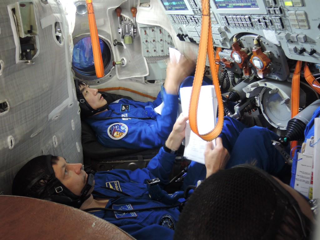
    An unmanned aerial vehicle searches wreckage for survivors in Pearlington, Miss., following Hurricane Katrina. The vehicle was operated by the Safety Security Rescue Research Center, one of the U.S. National Science Foundation’s Industry-University Cooperative Research Centers.
    Credit: Safety Security Rescue Research Center

    Robin Murphy directs the Center for Robot-Assisted Search and Rescue at Texas A&M University. She contributed this article to Space.com’s Expert Voices: Op-Ed & Insights.

    Hurricane Katrina saw the first deployment of drones in a disaster, setting the stage for such drone deployments worldwide — from the Fukushima Daiichi nuclear accident to the Nepal earthquake. The hurricane was a landmark for drone technologies, pivotal in their development for emergencies. 

    Katrina also contributed to policy changes that affect how drones deploy in disasters: Military equipment is now easier to deploy — but when the U.S. Federal Aviation Administration (FAA) “clarified” the certificate of authorization requirement for drones in 2006, they created restrictions for civilian flights that remain controversial to this day. 

    An evolution in flight?

    The last decade has seen an evolution in small unmanned aerial vehicles (or UAVs, the preferred name agencies use for civilian, as opposed to military, drones). This is especially true for rotorcraft, which have gone from miniature helicopters to multirotor systems that are less mechanically complex, easier to control and more compact than the radio-controlled helicopters that explored the aftermath of Katrina.

    Even bigger, but less visible, are changes to software and user interfaces, particularly for controlling UAVs, image quality. And, software now turns images into maps that are more accurate than satellite imagery and 3D reconstructions, letting responders see a disaster from any angle, like in a video game.

    What hasn’t changed is that federal, state and local urban search-and-rescue teams still don’t own UAVs or routinely use them — nor do they have clear procedures for deployment.

    Lessons from Katrina

    The Center for Robot-Assisted Search and Rescue (CRASAR), as part of the Florida State Emergency Response Team assisting Mississippi — and, later, during Katrina assisting L3 Communications as part of aid to the New Orleans region — deployed small unmanned aerial systems to the areas affected by Hurricane Katrina. 

    CRASAR provided an AeroVironment Raven fixed-wing vehicle, loaned by WinTec Arrowmaker with permission from the U.S. Special Operations Command, and a customized T-Rex miniature helicopter from Like90. 

    Two days after Katrina made landfall, CRASAR remotely flew the vehicles in Pearlington, Mississippi. The town had been cut off; all the roads were blocked with fallen trees, and the phone lines were wiped out. 

    The mission: Determine whether people were stranded and in immediate distress and if the cresting Pearl River was posing an immediate threat. 

    Fortunately, the answer was “no” — in both cases. The UAV video feed showed that, while the area was heavily damaged, the flooding was subsiding and people were working on clearing out the trees and damage. 

    A day later, CRASAR flew a third mission at Bay St. Louis to document the US-90 bridge damage and demonstrate UAV capabilities, and in November CRASAR returned with an iSENSYS IP-3 miniature helicopter, specifically designed for inspecting structures. The iSENSYS IP-3 flew 32 flights successfully and examined structural damage at seven multistory commercial buildings. The rotorcraft was able to provide views of the buildings from angles that were impossible to get from the ground or flyovers.

    The results not only helped engineers see that the storm’s wind damage was much less than expected but also led to a set of studies that would guide safe crew-organization practices used by responders in the United States, Europe and at the site of the Fukushima Daiichi nuclear accident. 

    The Katrina flights also showed structural inspection was not simply a matter of taking photographs. Structural specialists who viewed uploaded images had trouble comprehending the state of damage. Addressing such problems in “remote perception” remains a major open research question. 

    Drone monitoring Katrina

    Safety Security Rescue Research Center team members Mike Lotre, John Dugan and Robin Murphy monitor the UAVs during their deployment in Pearlington, Miss. The center is one of the U.S. NSF Industry-University Cooperative Research Centers.
    Credit: Safety Security Rescue Research Center

    Rapid response

    Since Katrina, UAVs have been used worldwide for disasters for two reasons. First, they provide better vantage points and higher-resolution images than satellites or manned planes and helicopters. And second, they deploy faster, and responders can control them tactically. 

    Unlike a manned helicopter or National Guard Predator that has to fly in from an airport or base, tactical teams can carry a UAV into a hot zone, deploy it on demand when they see the need and immediately get imagery — a far simpler and faster process than requesting imagery from aircraft controlled and coordinated by a centralized authority and then waiting for those craft to take the imagery and then download the imagery to the team, assuming there is sufficient connectivity.

    Quantifying success is difficult, similar to measuring the success of a manned helicopter or the value of a camera. UAVs are tools, and their value is in how they help responders. While they are cheaper to use than manned assets — Mesa County, Colorado estimates that its systems cost $25 per hour versus $10,000 to $15,000 per hour for a manned helicopter — cost has not been cited as the primary reason for deploying them at disasters. Instead, responders have cited UAVs’ new capabilities. 

    Fukushima Daiichi power plant

    Satellite image of the Fukushima Daiichi power plant three days after the Tohoku earthquake struck.
    Credit: GeoEye

    Digesting disaster data 

    The most visible change since Katrina has been the advent of multirotor craft. Fixed-wing UAVs still look very much like planes, though in newer models, the airframes are often conformable electronic boards providing both the skeleton and the “nervous system” for the vehicle. UAVs are now more likely to carry specialized payloads such as infrared and lidar. Whereas rotorcraft looked like miniature helicopters in 2005, rotorcraft used at recent disasters have been multirotor (with the exception of the Honeywell T-Hawk ducted fan used at Fukushima). 

    The less visible, but equally important and exciting, changes have been in software and user interfaces. As the platforms have matured in the past 10 years, the research and development work has shifted from aeronautics to data science. Data science — or, more specifically, emergency informatics — addresses how responders get the data they need to make decisions about response and recovery. 

    For example, 3D reconstructions of sites are now available through free photogrammetric programs — ones that provide a virtual reality environment — such as Microsoft’s ICE or through commercially available packages such as Agisoft and Pix4D. These programs can tile individual photos into a single high-resolution mosaic and then accurately compute the height of the terrain and the size of buildings, as well as estimate the amount of debris that needs to be cleaned up. 

    However, many companies are focusing more on optimizing data gathering for photogrammetrics for agriculture or pipeline inspection, neglecting what responders need and the best way to support them. Some missions, such as flood assessment at the Oso mudslides in Washington state, benefit from UAVs that are optimized for photogrammetrics. 

    Most of these systems are configured to fly preplanned missions and return with the data, with no way for responders to see what the UAV is seeing in real time. But other missions — such as general situation awareness and identification of survivors in distress — are time-critical, and every second counts. Responders still need to see video in real time and actively (but safely) direct robots without first having been trained as expert operators. 

    Robin Murphy and her team from the NSF Safety Security Rescue Research Center

    Robin Murphy and her team from the NSF Safety Security Rescue Research Center used the Like90 unmanned aerial vehicle to investigate buildings damaged by Hurricane Katrina.
    Credit: Like90, SSRRC

    Changing the rules

    UAV use at Katrina left an enduring legacy on policy, which has improved overall capabilities in disaster management but may have delayed UAV adoption because of the FAA’s reaction. On the positive side, the use of the Raven in Mississippi and the other military UAVs in New Orleans illustrated that the military and its reservoir of technology has a role in domestic disaster response. 

    When Katrina struck, the U.S. Department of Defense had potentially useful UAVs but was uncertain of how to deploy them because of the Posse Comitatus Act of 1878, which essentially says that the U.S. military can’t be used on U.S. soil. 

    It doesn’t apply to the National Guard, which is run by each state and reports to each state’s governor, but there was a fear that public perception would be that anything with camouflage was a violation and fringe groups would see it as the United States trying to curtail individual freedom. 

    Ironically, the Posse Comitatus Act was originally used to get federal troops enforcing Reconstruction after the Civil War out of the South. After Katrina, it prevented the South from getting disaster resources. As a result, the Posse Comitatus Insurrection Act was modified in 2006, and later, the U.S. Department of Defense was better integrated into the National Response Framework. 

    The use of UAVs following Katrina also led to the FAA’s clarification that small-UAV use required a certificate of authorization (COA) and could not be operated under “hobbyist” rules, creating a barrier to adoption and experimentation. 

    The clarification was due, in part, to alarms raised by the U.S. Coast Guard as to the vulnerability of their tactical helicopter and hoisting operations in New Orleans. Manned helicopters during a disaster typically operate at dangerously low altitudes, and a small bird strike can cause a crash. The presence of any unknown and uncoordinated aircraft puts them at risk for a fatal crash that might kill the very victims the Coast Guard is trying to help. 

    Standard policy, from the early days of aviation, is that when a pilot sees a nearby unknown aircraft, regardless of whether it’s manned or a hobbyist toy, the mission is stopped. A rescue flight can’t return until an investigation determines it is safe to fly in that area. This means a helicopter pilot would have to immediately stop hoisting a victim from a roof because someone was flying a UAV nearby, regardless of the intent or expertise of the UAV. The problem persists to this day, with UAVs interfering with manned aircraft working at the California wildfires and Texas floods. 

    While there is no report of manned aircraft actually canceling missions at Katrina, the possibility was high enough — and the concern from manned pilots who flew in New Orleans was real enough — that it could not be ignored. 

    The FAA announced the COA requirement six months after Katrina struck. The ruling effectively barred UAVs from disasters in the United States for nearly seven years, when the emergency COA process became more manageable. 

    If you’re a topical expert — researcher, business leader, author or innovator — and would like to contribute an op-ed piece, email us here.
    Credit: SPACE.com

    Where are the UAVs?

    UAVs have been used in more than 20 disasters worldwide since Katrina, yet in the United States, federal, state and local urban search-and-rescue teams still do not own small UAVs, routinely use UAVs or have clear procedures for deploying UAVs. The technology existed in 2005 and exists in 2015, but then as now, the technology isn’t being used. 

    Fire rescue departments don’t have grants set aside to purchase UAVs the way the police departments can buy bomb squad robots. Confusion over policies from the FAA and conflicting privacy constraints from federal, state and local interpretations of regulations discourage adoption. A recent FAA ruling allows companies such as Amazon — with the industry version of a COA, called a 333 exemption — to fly with more flexibility than a fire department with a COA. UAVs need regulatory advocacy and government funding to speed the adoption of UAVs for emergency management. Once adoption becomes prevalent, focused research and development will follow, creating a public sector market for UAVs and platforms that are even less expensive and easier to use.

    Ten years later, Hurricane Katrina is an example of the accelerating urbanization of disasters — increasing populations in urban centers situated along coasts with rising sea levels create significant social and infrastructure vulnerabilities to disasters. Let’s hope that 20 years later, Katrina will stand as an example of how new technology was introduced and adopted in emergency management. 

    Follow all of the Expert Voices issues and debates — and become part of the discussion — on Facebook, Twitter and Google+. The views expressed are those of the author and do not necessarily reflect the views of the publisher. This version of the article was originally published on Space.com.

  • [ISS / Japanese Experiment Module (KIBO)] The Exposed Pallet (EP) of the HTV5 was reinstalled into KOUNOTORI's Unpressurized Logistics Carrier (ULC).

    The Exposed Pallet (EP) of the HTV5 was reinstalled into KOUNOTORI’s Unpressurized Logistics Carrier (ULC).

    Last Updated: September 16, 2015

    After removed from the Kibo’s Exposed Facility(EF) by the JEM Remote Manipulator System (JEMRMS), the Exposed Pallet (EP) was handed over to the station’s robotic arm (Space Station Remote Manipulator System: SSRMS).

    Then, the EP was stowed into KOUNOTORI’s Unpressurized Logistics Carrier (ULC) at 11:41 p.m. (2:41 p.m. UTC) on September 15

    The Superconducting Submillimeter-Wave Limb-Emission Sounder (SMILES), Multi-mission Consolidated Equipment (MCE), and the U.S. payload Space Test Program – Houston 4 (STP-H4), all completed their missions, are mounted on the EP. They will be disposed with the KOUNOTORI5’s fiery reentry.

    *All times are Japan Standard Time (JST)

    This entry passed through the Full-Text RSS service – if this is your content and you’re reading it on someone else’s site, please read the FAQ at fivefilters.org/content-only/faq.php#publishers.

  • SpaceX Signs Deals to Launch 2 More Communications Satellites

    TurkmenÄlem52E/MonacoSat Satellite Launch
    SpaceX’s Falcon 9 rocket launches on April 27, 2015, from Cape Canaveral Air Force Station in Florida, carrying Thales Alenia Space’s TurkmenÄlem52E/MonacoSat satellite to orbit.
    Credit: SpaceX

    SpaceX has signed two new contracts to launch communications satellites a few years from now, the company announced Monday (Sept. 14). 

    SpaceX will loft one satellite for the Spanish company Hispasat on its Falcon 9 rocket and launch Saudi Arabia’s Arabsat 6A spacecraft on a Falcon Heavy. The launches will take place from Florida’s Cape Canaveral Air Force Station in late 2017 or 2018, SpaceX representatives said.

    Hawthorne, California-based SpaceX now has more than 60 launches on its manifest, with a total value of more than $7 billion, the company added in the new announcement, which was made at the World Satellite Business Week conference in Paris.

    “We are pleased to add these additional launches to our manifest,” Gywnne Shotwell, SpaceX president and chief operating officer, said in a statement. “The diversity of our missions and customers represents a strong endorsement of our capabilities, and reflects SpaceX’s efforts to provide a breadth of launch services to our growing customer base.”

    One of SpaceX’s customers is NASA. The company is flying at least 12 unmanned cargo missions to the International Space Station using its Dragon capsule and the Falcon 9 under a $1.6 billion deal with the space agency.

    The first six cargo missions were successful, but the seventh ended just after liftoff in late June when the Falcon 9 exploded. The accident was apparently caused by the failure of a faulty strut within the rocket, SpaceX representatives have said.

    Follow Elizabeth Howell @howellspace, or Space.com @Spacedotcom. We’re also on Facebook and Google+. Originally published on Space.com.

  • How Blue Origin's Suborbital Rocket Ride Works (Infographic)

    by Karl Tate, Infographics Artist   |   September 15, 2015 03:26pm ET

    blue origin, new shepard, suborbital, commercial space, space tourism, infographic

    New Shepard, named after Mercury astronaut and Apollo moonwalker Alan Shepard, is Jeff Bezos’ scheme for high-altitude, near-space tourism. A propulsion module (rocket) lobs the crew to an altitude of 307,000 feet (93,573 meters) – 

    well above the height required to earn NASA astronaut wings. The rocket returns to its launch site and lands, while the crew capsule descends on a parachute.

    The six-person crew capsule has an interior volume of 530 cubic feet (15 cubic meters). The capsule has six big observation windows that the company boasts are the largest-ever windows on a spacecraft.

    Embed: Paste the code below into your site.

    More Infographics

    Once in a Blue Moon Event Is Not Really Blue (Infographic)

    Infographic: huge meteor explosion over Russia is compared to the Tunguska event

    Huge Russian Meteor Blast is Biggest Since 1908 (Infographic)

    Infographic: How the huge ALMA radio telescope works.

    How the Huge ALMA Radio Telescope Works (Infographic)

  • Cassini Finds Global Ocean in Saturn's Moon Enceladus

    A global ocean lies beneath the icy crust of Saturn’s geologically active moon Enceladus, according to new research using data from NASA’s Cassini mission.

  • Cassini Finds Global Ocean in Saturn's Moon Enceladus

    A global ocean lies beneath the icy crust of Saturn’s geologically active moon Enceladus, according to new research using data from NASA’s Cassini mission.

  • Watch 2000+ Comets Whiz Past The Sun | 1998 to 2010 Animated

    Credit: NASA/GSFC